Betsukai, Hokkaido
| Betsukai 別海町 | |||
|---|---|---|---|
| Town | |||
| |||
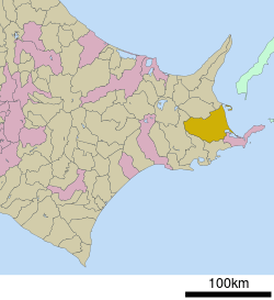 Location of Betsukai in Hokkaido (Nemuro Subprefecture) | |||
 Betsukai Location in Japan | |||
| Coordinates: 43°24′N 145°7′E / 43.400°N 145.117°ECoordinates: 43°24′N 145°7′E / 43.400°N 145.117°E | |||
| Country | Japan | ||
| Region | Hokkaido | ||
| Prefecture | Hokkaido (Nemuro Subprefecture) | ||
| District | Notsuke | ||
| Area | |||
| • Total | 1,320.15 km2 (509.71 sq mi) | ||
| Population (April 30, 2017) | |||
| • Total | 15,179 | ||
| • Density | 11/km2 (30/sq mi) | ||
| Time zone | UTC+9 (JST) | ||
| Website |
betsukai | ||

Betsukai (別海町 Betsukai-chō) is a town located in Nemuro Subprefecture, Hokkaido, Japan. As of April 30, 2017, the town has an estimated population of 15,179,[1] and an area of 1,320.15 km² (second largest in Hokkaido). The town is primarily agricultural, with numerous dairy farms. It comprises a part of the agricultural region referred to as "Milk Land Hokkaido".
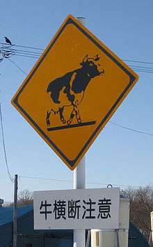
Street sign in Betsukai
History
- 1923 - 6 villages combine, forming the village of Betsukai.
- 1971 - Betsukai Village becomes Betsukai Town.
References
- ↑ "Population of Betsukai Town" (in Japanese). Japan: Betsukai Town. Retrieved 17 May 2017.
External links

- Official Website (in Japanese)
| ||||||||||
| ||||||||||
| ||||||||||
| ||||||||||
| ||||||||||
| ||||||||||
| ||||||||||
| ||||||||||
| ||||||||||
| ||||||||||
| ||||||||||
| ||||||||||
| ||||||||||
| ||||||||||
| Authority control |
|---|
This article is issued from
Wikipedia.
The text is licensed under Creative Commons - Attribution - Sharealike.
Additional terms may apply for the media files.