Beverly, West Virginia
| Beverly, West Virginia | |
|---|---|
| Town | |
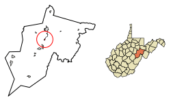 Location of Beverly in Randolph County, West Virginia. | |
| Coordinates: 38°51′2″N 79°52′3″W / 38.85056°N 79.86750°WCoordinates: 38°51′2″N 79°52′3″W / 38.85056°N 79.86750°W | |
| Country | United States |
| State | West Virginia |
| County | Randolph |
| Area[1] | |
| • Total | 0.45 sq mi (1.17 km2) |
| • Land | 0.45 sq mi (1.17 km2) |
| • Water | 0 sq mi (0 km2) |
| Elevation | 1,962 ft (598 m) |
| Population (2010)[2] | |
| • Total | 702 |
| • Estimate (2016)[3] | 679 |
| • Density | 1,560.0/sq mi (602.3/km2) |
| Time zone | UTC-5 (Eastern (EST)) |
| • Summer (DST) | UTC-4 (EDT) |
| ZIP code | 26253 |
| Area code(s) | 304 |
| FIPS code | 54-06988[4] |
| GNIS feature ID | 1553884[5] |
Beverly is a town in Randolph County, West Virginia, USA. It is situated on the Tygart Valley River and had a population of 702 at the 2010 census.
Beverly was the county seat of Randolph County, Virginia (later West Virginia) for a century — from 1790 until 1890 — after which the nearby settlement of Elkins assumed that role following an intense local political "war".
Geography
Beverly is located at 38°51′2″N 79°52′3″W / 38.85056°N 79.86750°W (38.850600, -79.867444).[6]
According to the United States Census Bureau, the town has a total area of 0.45 square miles (1.17 km2), all of it land.[1]
History
The origin of the name Beverly is disputed.[7]
In January 1865, Confederate General Thomas L. Rosser took 300 men, crossed the Allegheny Mountains to Beverly in deep snow and bitter cold and surprised and captured two Union infantry regiments in their works there. Some 580 prisoners were taken. (Most of the men in Rosser's command were recruits from [West] Virginia.[8]) Rosser's troops partially burnt the Beverly Covered Bridge (1846-47), the earliest of Lemuel Chenoweth's celebrated wooden covered bridges, but Chenoweth rebuilt it in 1872 and '73.
Demographics
| Historical population | |||
|---|---|---|---|
| Census | Pop. | %± | |
| 1880 | 235 | — | |
| 1890 | 343 | 46.0% | |
| 1900 | 464 | 35.3% | |
| 1910 | 438 | −5.6% | |
| 1920 | 442 | 0.9% | |
| 1930 | 431 | −2.5% | |
| 1940 | 484 | 12.3% | |
| 1950 | 515 | 6.4% | |
| 1960 | 441 | −14.4% | |
| 1970 | 470 | 6.6% | |
| 1980 | 475 | 1.1% | |
| 1990 | 696 | 46.5% | |
| 2000 | 651 | −6.5% | |
| 2010 | 702 | 7.8% | |
| Est. 2016 | 679 | [3] | −3.3% |
| U.S. Decennial Census[9] | |||
2010 census
As of the census[2] of 2010, there were 702 people, 323 households, and 199 families residing in the town. The population density was 1,560.0 inhabitants per square mile (602.3/km2). There were 360 housing units at an average density of 800.0 per square mile (308.9/km2). The racial makeup of the town was 98.0% White, 0.1% African American, 0.4% Native American, and 1.4% from two or more races. Hispanic or Latino of any race were 0.3% of the population.
There were 323 households of which 30.3% had children under the age of 18 living with them, 36.2% were married couples living together, 21.7% had a female householder with no husband present, 3.7% had a male householder with no wife present, and 38.4% were non-families. 33.4% of all households were made up of individuals and 13.3% had someone living alone who was 65 years of age or older. The average household size was 2.17 and the average family size was 2.75.
The median age in the town was 40.5 years. 24.4% of residents were under the age of 18; 8.1% were between the ages of 18 and 24; 22.5% were from 25 to 44; 27.5% were from 45 to 64; and 17.4% were 65 years of age or older. The gender makeup of the town was 46.6% male and 53.4% female.
2000 census
As of the census[4] of 2000, there were 651 people, 285 households, and 190 families residing in the town. The population density was 1,473.4 inhabitants per square mile (571.3/km²). There were 313 housing units at an average density of 708.4 per square mile (274.7/km²). The racial makeup of the town was 98.77% White, 0.31% Native American, 0.46% Asian, and 0.46% from two or more races. Hispanic or Latino of any race were 1.08% of the population.
There were 285 households out of which 36.1% had children under the age of 18 living with them, 41.1% were married couples living together, 19.6% had a female householder with no husband present, and 33.3% were non-families. 28.8% of all households were made up of individuals and 12.3% had someone living alone who was 65 years of age or older. The average household size was 2.25 and the average family size was 2.71.
In the town, the population was spread out with 24.4% under the age of 18, 10.9% from 18 to 24, 26.3% from 25 to 44, 26.0% from 45 to 64, and 12.4% who were 65 years of age or older. The median age was 36 years. For every 100 females there were 86.5 males. For every 100 females age 18 and over, there were 75.7 males.
The median income for a household in the town was $21,875, and the median income for a family was $24,722. Males had a median income of $25,714 versus $16,250 for females. The per capita income for the town was $15,620. About 27.4% of families and 31.4% of the population were below the poverty line, including 40.0% of those under age 18 and 34.7% of those age 65 or over.
Climate
This climatic region is typified by large seasonal temperature differences, with warm to hot (and often humid) summers and cold (sometimes severely cold) winters. According to the Köppen Climate Classification system, Beverly has a humid continental climate, abbreviated "Dfb" on climate maps.[10]
References
- 1 2 "US Gazetteer files 2010". United States Census Bureau. Archived from the original on 2012-07-14. Retrieved 2013-01-24.
- 1 2 "American FactFinder". United States Census Bureau. Retrieved 2013-01-24.
- 1 2 "Population and Housing Unit Estimates". Retrieved June 9, 2017.
- 1 2 "American FactFinder". United States Census Bureau. Archived from the original on 2013-09-11. Retrieved 2008-01-31.
- ↑ "US Board on Geographic Names". United States Geological Survey. 2007-10-25. Retrieved 2008-01-31.
- ↑ "US Gazetteer files: 2010, 2000, and 1990". United States Census Bureau. 2011-02-12. Retrieved 2011-04-23.
- ↑ Kenny, Hamill (1945). West Virginia Place Names: Their Origin and Meaning, Including the Nomenclature of the Streams and Mountains. Piedmont, WV: The Place Name Press. p. 110.
- ↑ Snell, Mark A., West Virginia and the Civil War, History Press, 2011, pg. 167
- ↑ "Census of Population and Housing". Census.gov. Archived from the original on May 12, 2015. Retrieved June 4, 2015.
- ↑ Climate Summary for Beverly, West Virginia
External links
- History and buildings of Beverly
- Battle of Rich Mountain, fought just west of Beverly
Municipalities and communities of Randolph County, West Virginia, United States | ||
|---|---|---|
| City |  | |
| Towns | ||
| CDPs | ||
| Unincorporated communities |
| |
| Ghost towns | ||
| Footnotes | ‡This populated place also has portions in an adjacent county or counties | |