Packsville, West Virginia
| Packsville, West Virginia | |
|---|---|
| Unincorporated community | |
 Packsville, West Virginia Location within the state of West Virginia  Packsville, West Virginia Packsville, West Virginia (the US) | |
| Coordinates: 37°57′07″N 81°31′41″W / 37.95194°N 81.52806°WCoordinates: 37°57′07″N 81°31′41″W / 37.95194°N 81.52806°W | |
| Country | United States |
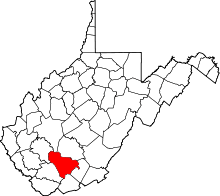
| State | West Virginia |
| County | Raleigh |
| Elevation | 899 ft (274 m) |
| Time zone | UTC-5 (Eastern (EST)) |
| • Summer (DST) | UTC-4 (EDT) |
| Area code(s) | 304 & 681 |
| GNIS feature ID | 1555290[1] |
Packsville is an unincorporated community in Raleigh County, West Virginia, United States. Packsville is located on the Little Marsh Fork 4.4 miles (7.1 km) south-southeast of Sylvester.[2]
The community was named after the local Pack family.[3]
References
- ↑ "Packsville". Geographic Names Information System. United States Geological Survey.
- ↑ Raleigh County, West Virginia General Highway Map (PDF) (Map). West Virginia Department of Transportation. 2011. p. 1. Retrieved October 28, 2011.
- ↑ Kenny, Hamill (1945). West Virginia Place Names: Their Origin and Meaning, Including the Nomenclature of the Streams and Mountains. Piedmont, WV: The Place Name Press. p. 466.
This article is issued from
Wikipedia.
The text is licensed under Creative Commons - Attribution - Sharealike.
Additional terms may apply for the media files.