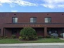
Vienna, West Virginia
| Vienna, West Virginia | |
|---|---|
| City | |
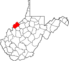
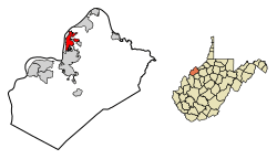 Location of Vienna in Wood County, West Virginia. | |
| Coordinates: 39°19′31″N 81°32′34″W / 39.32528°N 81.54278°WCoordinates: 39°19′31″N 81°32′34″W / 39.32528°N 81.54278°W | |
| Country | United States |
| State | West Virginia |
| County | Wood |
| Area[1] | |
| • Total | 3.79 sq mi (9.82 km2) |
| • Land | 3.79 sq mi (9.82 km2) |
| • Water | 0 sq mi (0 km2) |
| Elevation | 636 ft (194 m) |
| Population (2010)[2] | |
| • Total | 10,749 |
| • Estimate (2016)[3] | 10,459 |
| • Density | 2,836.1/sq mi (1,095.0/km2) |
| Time zone | UTC-5 (Eastern (EST)) |
| • Summer (DST) | UTC-4 (EDT) |
| ZIP codes | 26101, 26105 |
| Area code(s) | 304 |
| FIPS code | 54-83500[4] |
| GNIS feature ID | 1555890[5] |
Vienna is a city in Wood County, West Virginia, along the Ohio River. It is next to Parkersburg. The population was 10,749 at the 2010 census. It is the third largest city by population in the Parkersburg–Vienna–Marietta metropolitan area.
History
In 1794, Dr. Joseph Spencer gave the city its name after Vienna, New Jersey, where he had participated in a Revolutionary War battle. It began as a 5,000 acre settlement, a grant to Dr. Spencer for his services during the war. Charles R. Blair, was Vienna's first mayor after it was incorporated in 1935.[6] Vienna was known for Vitrolite production until the 1940s.
Geography
Vienna is located at 39°19′31″N 81°32′34″W / 39.32528°N 81.54278°W (39.325324, −81.542845).[7]
According to the United States Census Bureau, the city has a total area of 3.79 square miles (9.82 km2), all of it land.[1]
Demographics
| Historical population | |||
|---|---|---|---|
| Census | Pop. | %± | |
| 1940 | 2,338 | — | |
| 1950 | 6,020 | 157.5% | |
| 1960 | 9,381 | 55.8% | |
| 1970 | 11,549 | 23.1% | |
| 1980 | 11,618 | 0.6% | |
| 1990 | 10,862 | −6.5% | |
| 2000 | 10,861 | 0.0% | |
| 2010 | 10,749 | −1.0% | |
| Est. 2016 | 10,459 | [3] | −2.7% |
| U.S. Decennial Census[8] 2014 Estimate[9] | |||
2010 census
As of the census[2] of 2010, there were 10,749 people, 4,707 households, and 3,054 families residing in the city. The population density was 2,836.1 inhabitants per square mile (1,095.0/km2). There were 5,091 housing units at an average density of 1,343.3 per square mile (518.7/km2). The racial makeup of the city was 95.9% White, 1.1% African American, 0.2% Native American, 1.4% Asian, 0.3% from other races, and 1.0% from two or more races. Hispanic or Latino of any race were 0.8% of the population.
There were 4,707 households of which 26.5% had children under the age of 18 living with them, 50.5% were married couples living together, 10.4% had a female householder with no husband present, 4.0% had a male householder with no wife present, and 35.1% were non-families. 30.4% of all households were made up of individuals and 13.4% had someone living alone who was 65 years of age or older. The average household size was 2.24 and the average family size was 2.77.
The median age in the city was 43.8 years. 20.2% of residents were under the age of 18; 8.1% were between the ages of 18 and 24; 23% were from 25 to 44; 29.1% were from 45 to 64; and 19.6% were 65 years of age or older. The gender makeup of the city was 47.0% male and 53.0% female.
2000 census
As of the census[4] of 2000, there were 10,861 people, 4,733 households, and 3,152 families residing in the city. The population density was 2,895.8 people per square mile (1,118.3/km²). There were 5,074 housing units at an average density of 1,352.8 per square mile (522.4/km²). The racial makeup of the city was 96.70% White, 0.95% African American, 0.17% Native American, 1.34% Asian, 0.02% Pacific Islander, 0.14% from other races, and 0.68% from two or more races. Hispanic or Latino of any race were 0.50% of the population.
There were 4,733 households out of which 26.5% had children under the age of 18 living with them, 55.3% were married couples living together, 9.1% had a female householder with no husband present, and 33.4% were non-families. 30.3% of all households were made up of individuals and 14.8% had someone living alone who was 65 years of age or older. The average household size was 2.29 and the average family size was 2.84.
In the city, the population was spread out with 21.2% under the age of 18, 7.0% from 18 to 24, 25.3% from 25 to 44, 27.4% from 45 to 64, and 19.1% who were 65 years of age or older. The median age was 43 years. For every 100 females, there were 87.9 males. For every 100 females age 18 and over, there were 83.5 males.
The median income for a household in the city was $39,220, and the median income for a family was $49,477. Males had a median income of $41,779 versus $25,122 for females. The per capita income for the city was $24,452. About 5.3% of families and 7.7% of the population were below the poverty line, including 10.2% of those under age 18 and 7.6% of those age 65 or over.
Education
Vienna is home to Jackson Junior High School]. According to the school's web site, it was recognized as a West Virginia School of Excellence in 1998, a West Virginia Blue Ribbon School in 1999, a United States Department of Education Blue Ribbon School of Excellence in 1999-2000, and a West Virginia Exemplary School in 2000, 2004, and 2006.[10] Jackson is regarded as one of the best middle schools in the state of West Virginia. Its feeder schools are Greenmont, Vienna, and Neale Elementary Schools.
Pollution
PFOA pollution in a stream in Vienna that originated in a DuPont chemical company landfill was the trigger for a landmark class-action lawsuit over PFOA contamination in the region.[11]
See also
References
- 1 2 "US Gazetteer files 2010". United States Census Bureau. Archived from the original on 2012-01-24. Retrieved 2013-01-24.
- 1 2 "American FactFinder". United States Census Bureau. Retrieved 2013-01-24.
- 1 2 "Population and Housing Unit Estimates". Retrieved June 9, 2017.
- 1 2 "American FactFinder". United States Census Bureau. Retrieved 2008-01-31.
- ↑ "US Board on Geographic Names". United States Geological Survey. 2007-10-25. Retrieved 2008-01-31.
- ↑ "Vienna History". vienna-wv.com.
- ↑ "US Gazetteer files: 2010, 2000, and 1990". United States Census Bureau. 2011-02-12. Retrieved 2011-04-23.
- ↑ United States Census Bureau. "Census of Population and Housing". Retrieved June 20, 2015.
- ↑ "Population Estimates". United States Census Bureau. Archived from the original on May 22, 2015. Retrieved June 20, 2015.
- ↑ "School Overview". Jackson Middle School. Retrieved April 27, 2009.
- ↑ Rich, Nathaniel (January 6, 2016). "The Lawyer Who Became DuPont's Worst Nightmare". New York Times.