Grafton, West Virginia
| Grafton, West Virginia | |
|---|---|
| City | |
.jpg) | |
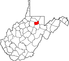
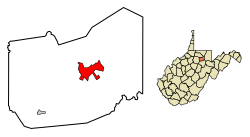 Location of Grafton in Taylor County, West Virginia. | |
| Coordinates: 39°20′30″N 80°1′11″W / 39.34167°N 80.01972°WCoordinates: 39°20′30″N 80°1′11″W / 39.34167°N 80.01972°W | |
| Country | United States |
| State | West Virginia |
| County | Taylor |
| Area[1] | |
| • Total | 3.80 sq mi (9.84 km2) |
| • Land | 3.67 sq mi (9.51 km2) |
| • Water | 0.13 sq mi (0.34 km2) |
| Elevation | 1,024 ft (312 m) |
| Population (2010)[2] | |
| • Total | 5,164 |
| • Estimate (2016)[3] | 5,127 |
| • Density | 1,407.1/sq mi (543.3/km2) |
| Time zone | UTC-5 (Eastern (EST)) |
| • Summer (DST) | UTC-4 (EDT) |
| ZIP code | 26354 |
| Area code(s) | 304 |
| FIPS code | 54-32716[4] |
| GNIS feature ID | 1554590[5] |
Grafton is a city in — and the county seat of — Taylor County, West Virginia, USA.[6] The population was 5,164 at the 2010 census. Both of West Virginia's national cemeteries are located in Grafton. Mother's Day was founded in Grafton on May 10, 1908 and the city is home to the International Mother's Day Shrine.[7]
Grafton was among the first cities in the United States to observe Memorial Day.[7] It originally developed as a junction point for the Baltimore and Ohio Railroad. It served numerous branches of a network that was vital to the regional coal industry.
History
Earliest settlers
Grafton developed from early European-American settlements at the confluence of Three Fork Creek with the Tygart Valley River, part of the headwaters region of the Monongahela River watershed. In 1776, Virginia's remote District of West Augusta was divided into three counties, including Monongalia County, which included what are now Taylor County and Grafton.
Among the earliest settlers were James Current (ca. 1730-1822) and his family. He was a Scots-Irish immigrant who fought in the Revolutionary War in 1778, had landed in Maryland and moved into the interior. He was living in Monongalia County with his family by 1782 when he was recorded on a census there.[8] According to family tradition, Current traded a "gray horse" for 1,300 acres of land located where present-day Grafton developed.[9] James and his wife Margaret are buried in Bluemont Cemetery (part of his original property). Current's grave is the only one in Grafton known to belong to a veteran of the Revolutionary War.[10]
Turnpike and railroad
John Wolverton Blue (1803-1889) was in charge of the construction of Virginia's Northwestern Turnpike from Aurora to the Tygart Valley. Visiting the future site of Grafton in 1833, he stayed overnight with the Currents.[11] According to a local historian, "Blue, upon awakening the next morning, heard the wife of Current sobbing bitterly" over the impending loss of her "cabin home...[and] vegetable and flower garden" because of the planned right-of-way for the road. "Mr. Blue, a Virginian of the old school, was greatly moved...and...an offer of $300 for 900 acres...and their ruined home...was quickly accepted."[12]
Blue's property was developed as Blueville and it — along with the nearby area called "Bridge Valley" (present- day Fetterman) — began to grow after the Turnpike was completed in 1834. In this same period., Blue also supervised the construction of a covered bridge over the Tygart River. It is no longer extant.
In 1847, the Virginia General Assembly passed an act authorizing the Baltimore and Ohio Railroad Company to extend its line to the Ohio River at Wheeling. Thomas S. Haymond (1794–1869), a lawyer and U.S. Congressman from nearby Marion County, arranged for a clause to be added to the bill so that the railroad would pass through his hometown of Fairmont. The clause specified that the railroad would "reach or cross the Tygart's Valley River at or within three miles of the mouth of Three Fork Creek in the county of Taylor".[13] This clause effectively re-routed the line. and Grafton developed at the noted confluence.
The B&O work crews completed the line on January 11, 1852 and the first "iron horse" arrived two days later. This was the first trans-Appalachian railroad. Within a year Grafton had emerged as a booming railroad town with several residences and stores. As the railroad facilities were developed, local land was surveyed for the new town, which was chartered on March 15, 1856 in the Virginia General Assembly.[14]
The name
The origin of the name "Grafton" — originally Grafton Junction[15] — is disputed. The city may have been named for John Grafton, a civil engineer of the B&O.[10] Alternatively, railroad crews may have referred to the town as "Graftin" because it was the point at which a number of branch railroad lines met (grafted to) the railroad's mainline.[16]
Civil War
Due to the importance of the B&O Railroad for the movement of troops and supplies, Grafton was a strategic point during the early stages of the Civil War; both sides tried to control it. Most residents sided with the Union, but the people of Grafton and this area were divided in their loyalties. Union supporters joined the Grafton Guards and southern supporters joined the Confederate Letcher's Guard. On the evening of May 22, 1861, the two forces had a small skirmish in the Town of Fetterman (now a part of Grafton), resulting in the death of Thornsbury Bailey Brown, the first soldier killed in the Civil War.
The Confederate forces were pushed south of Grafton to Philippi by Union troops under General B.J. Kelley and General George McClellan. On June 3, 1861, Kelley's forces defeated the Confederates led by Colonel George A. Porterfield. Although the Union controlled the B&O terminal in Grafton, the Confederates often raided the area to disrupt its operations.[14]
National Cemeteries
Thornsbury Bailey Brown was the first soldier killed in the Civil War, at Fetterman, now part of Grafton.[10] He is interred at the Grafton National Cemetery. This was opened in 1868 in order to provide a burial ground for Union soldiers who died in West Virginia’s military hospitals and battlefields. The Federal Government selected Grafton as the site of the national cemetery for its proximity to the Maple Avenue Cemetery, which already contained the remains of many US Civil War veterans.
On June 14, the first governor of West Virginia, Arthur Boreman, officially dedicated the cemetery. The cemetery contains more than 2,100 interments, including 1,252 Union soldiers. 613 Civil War soldiers are buried as unknowns and their graves are identified with six-inch square marble markers. In 1875, an Act of Congress was passed authorizing "preservation and maintenance" of the cemetery. Two plaques on the lowest terrace contain stanzas from Theodore O’Hara’s poem "Bivouac of the Dead."
Memorial Day services at Grafton National Cemetery include a special tradition known locally as "Flower Strewing Day." Historically, each year a parade begins in downtown Grafton and winds to the cemetery, where town children place flowers at each grave marker. The day concludes with a memorial service officiated by a prominent West Virginian. Every governor, except one who served a term of only six days, has spoken at the Grafton National Cemetery at least once during their term in office.[17]
Post-war growth
Following the Civil War, Grafton continued to grow and prosper, developing into a major retail and industrial center for North Central West Virginia. Grafton was visited by President U.S. Grant on 23 September 1872 as part of his reelection campaign. Grant's speech was interrupted several times by noisy southern sympathizers.[18]
In 1878, Grafton was designated as the county seat, formerly Pruntytown. Most of present-day Grafton was built during the period from 1890 to 1930. John T. McGraw, a financier and major contributor to most of Grafton's buildings, was the principal town builder. Besides his bank, McGraw built a number of buildings along Main Street, and also the streetcar system that was used for many years.
20th century
Tygart Dam was constructed about 2 miles south of Grafton, between 1934 and 1938 by the Works Progress Administration of the Franklin D. Roosevelt administration. President Roosevelt visited the city and remarked on such projects on October 1, 1936, on a stump tour; he gained a landslide re-election the following month. Upstream of the dam, Tygart Lake State Park was designated to preserve recreation areas around the man-made lake. The Tygart Valley River flows through Grafton.
Grafton continued to prosper throughout much of the early 20th century, based on the importance of the railroad in area and national economy. But in the early 1950s, the Carr China Plant closed and left hundreds of residents unemployed. In the late 1950s, Hazel Atlas Glass Plant closed and also left hundreds of residents without jobs. In 1958, the women of Grafton organized a parade on Main Street to attract jobs for residents of the community. This parade received national attention. Grafton was the chosen site of a plastic baby toys manufacturer. Because of the residents' efforts, Grafton was given an All-America City Award by the National Civic League in 1962, the smallest city that year to receive the award.
Although instrumental to the city's early growth and economy, the railroad inhibited its expansion. In the 1920s smoke abatement experts reported that the combination of high hills, low wind velocity, and frequent railroad traffic, created air quality problems for the city and its business district, which was adjacent to the area of intense railroad activity. The resulting smoke from the railroad industry was a chief factor in hindering the growth of the city. Restructuring of the railroads and heavy industry through the late 20th century resulted in the loss of more jobs and, ultimately, population. People moved elsewhere for work.[19]
In the early 1980s, the railroad relocated hundreds of jobs to Jacksonville, Florida. Grafton suffered a severe economic and emotional loss from these changes.
The 1985 Election day floods were notable in Grafton. Most of the 47 people killed in this incident were in Pendleton and Grant counties, according to the National Weather Service.[20] Flooding in the Tygart Valley River basin (a tributary to the Monongahela River) set new records for peak discharge at all five of the long-term unregulated guaging stations in the basin. However, the peaks were not as extreme, relative to the previous peaks of record, as those in the Cheat River and South Branch Potomac River basins. Recurrence intervals for the peaks equaled or exceeded 50 years at all five of the aforementioned sites in the Tygart basin, and four were in excess of 100 years. Also, at one newly established guaging station, Three Forks Creek near Grafton, the peak discharge, 12,000 ft3/s, was estimated to exceed the 100-year recurrence interval.[21]
.jpg)
Historic places
The Grafton Downtown Commercial Historic District was listed on the National Register of Historic Places in 1984 and the Grafton National Cemetery was listed in 1982.[22]
Geography
Grafton is located at 39°20′30″N 80°1′11″W / 39.34167°N 80.01972°W (39.341757, -80.019817),[23] along the Tygart Valley River. Tygart Lake State Park is a major nearby tourist attraction.
According to the United States Census Bureau, the city has a total area of 3.80 square miles (9.84 km2), of which, 3.67 square miles (9.51 km2) is land and 0.13 square miles (0.34 km2) is water.[1]
Demographics
| Historical population | |||
|---|---|---|---|
| Census | Pop. | %± | |
| 1860 | 891 | — | |
| 1870 | 1,987 | 123.0% | |
| 1880 | 3,030 | 52.5% | |
| 1890 | 3,159 | 4.3% | |
| 1900 | 5,650 | 78.9% | |
| 1910 | 7,563 | 33.9% | |
| 1920 | 8,517 | 12.6% | |
| 1930 | 7,737 | −9.2% | |
| 1940 | 7,431 | −4.0% | |
| 1950 | 7,365 | −0.9% | |
| 1960 | 5,791 | −21.4% | |
| 1970 | 6,433 | 11.1% | |
| 1980 | 6,845 | 6.4% | |
| 1990 | 5,524 | −19.3% | |
| 2000 | 5,489 | −0.6% | |
| 2010 | 5,164 | −5.9% | |
| Est. 2016 | 5,127 | [3] | −0.7% |
| U.S. Decennial Census[24] | |||
2010 census
As of the census[2] of 2010, there were 5,164 people, 2,192 households, and 1,357 families residing in the city. The population density was 1,407.1 inhabitants per square mile (543.3/km2). There were 2,512 housing units at an average density of 684.5 per square mile (264.3/km2). The racial makeup of the city was 97.1% White, 0.7% African American, 0.3% Native American, 0.2% Asian, 0.1% from other races, and 1.5% from two or more races. Hispanic or Latino of any race were 0.9% of the population.
There were 2,192 households of which 29.0% had children under the age of 18 living with them, 41.3% were married couples living together, 15.0% had a female householder with no husband present, 5.6% had a male householder with no wife present, and 38.1% were non-families. 33.8% of all households were made up of individuals and 15.3% had someone living alone who was 65 years of age or older. The average household size was 2.29 and the average family size was 2.92.
The median age in the city was 41.7 years. 21.9% of residents were under the age of 18; 8.4% were between the ages of 18 and 24; 23.9% were from 25 to 44; 26.9% were from 45 to 64; and 19% were 65 years of age or older. The gender makeup of the city was 47.6% male and 52.4% female.
2000 census
As of the census[4] of 2000, there were 5,489 people, 2,277 households, and 1,448 families residing in the city. The population density was 1,491.1 people per square mile (575.9/km²). There were 2,575 housing units at an average density of 699.5 per square mile (270.2/km²). The racial makeup of the city was 98.07% White, 0.84% African American, 0.27% Native American, 0.16% Asian, 0.05% from other races, and 0.60% from two or more races. Hispanic or Latino people of any race comprised 0.67% of the population.
There were 2,277 households out of which 29.4% had children under the age of 18 living with them, 45.4% were married couples living together, 14.2% had a female householder with no husband present, and 36.4% were non-families. 33.2% of all households were made up of individuals and 17.9% had someone living alone who was 65 years of age or older. The average household size was 2.33 and the average family size was 2.95.
In the city the population was spread out with 23.6% under the age of 18, 7.7% from 18 to 24, 25.4% from 25 to 44, 22.0% from 45 to 64, and 21.3% who were 65 years of age or older. The median age was 40 years. For every 100 females, there were 87.1 males. For every 100 females age 18 and over, there were 82.2 males.
The median income for a household in the city was $18,981, and the median income for a family was $25,161. Males had a median income of $22,765 versus $16,629 for females. The per capita income for the city was $9,616. About 26.6% of families and 35.1% of the population were below the poverty line, including 51.2% of those under age 18 and 15.7% of those age 65 or over.
Notable people
- Clair Bee, basketball coach for Long Island University and author
- Marmaduke H. Dent, justice of West Virginia Supreme Court of Appeals (born in Granville, lived in Grafton most of his life)
- Frank Gatski, aka "Gunner Gatski", Pro Football Hall of Fame center for Cleveland Browns
- Anna Jarvis, founder of Mother's Day
- Frances Benjamin Johnston, early photographer and photojournalist; born in Grafton
- George Preston Marshall, longtime owner and president of NFL's Washington Redskins
- Eldora Marie Bolyard Nuzum, first female editor of daily newspaper in West Virginia and interviewer of U.S. presidents[25]
- James W. Stansberry, United States Air Force lieutenant general.
Gallery
- Railroad bridge at Grafton in 1859
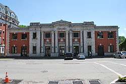 Grafton Baltimore and Ohio Railroad Depot
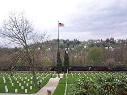 Grafton National Cemetery
 International Mothers Day Shrine
%2C_1818_-_9-1905.png) Valley Falls, near Grafton
Valley Falls, near Grafton
References
Citations
- 1 2 "US Gazetteer files 2010". United States Census Bureau. Archived from the original on 2012-01-24. Retrieved 2013-01-24.
- 1 2 "American FactFinder". United States Census Bureau. Retrieved 2013-01-24.
- 1 2 "Population and Housing Unit Estimates". Retrieved June 9, 2017.
- 1 2 "American FactFinder". United States Census Bureau. Archived from the original on 2013-09-11. Retrieved 2008-01-31.
- ↑ "US Board on Geographic Names". United States Geological Survey. 2007-10-25. Retrieved 2008-01-31.
- ↑ "Find a County". National Association of Counties. Archived from the original on 2011-05-31. Retrieved 2011-06-07.
- 1 2 nps.gov: "National Register of Historic Places - Andrews Methodist Episcopal Church" Archived 2007-03-14 at the Wayback Machine.
- ↑ Heads of families at the first census of the United States taken in the year 1790: records of the state enumerations, 1782 to 1785; Washington: G.P.O., 1908, pg 35.
- ↑ Current, Anne E. (1906), Genealogy of the Current and Hobson Families; New Castle, Indiana: Mark O. Waters, pp 2-4.
- 1 2 3 graftonwv.com: "ABOUT GRAFTON" Archived 2010-10-28 at the Wayback Machine.
- ↑ Core, Earl L. (1974–84), The Monongalia Story: A Bicentennial History, Parsons, W. Va.: McClain Printing Co., 5 volumes; Vol. III: Discord (1979), pg 117.
- ↑ Brinkman, Charles (1939-42), The History of Taylor County, Chapt. 13; published in installments in the Grafton Sentinel; 2 May issue. (These newspaper columns, published from 18 Apr 1939 to 29 Jun 1942 by the Grafton Sentinel, are compiled by the Taylor County Historical and Genealogical Society in three volumes [Vol. 1, 1989; Vol. 2, 1992; Vol. 3, 1992]. The columns are produced as 890 "chapters" in the reprinted work.) James Current and his wife Margaret (Richardson) (1737-1830) had both died, so the "wife of Current" referred to may have been one of their daughters-in-law.
- ↑ Core, Op. cit., pg 292.
- 1 2 "Archived copy". Archived from the original on 2010-10-28. Retrieved 2010-10-13.
- ↑ Brinkman (1939-42), Op. cit., Vol. 1, pg 208.
- ↑ Gannett, Henry (1905). The Origin of Certain Place Names in the United States. Govt. Print. Off. p. 140.
- ↑ nps.gov: "Civil War Era National Cemeteries: Honoring Those Who Served - Grafton National Cemetery", National Park Service
- ↑ Brinkman (1939-42), Op. cit., Vol. 1, pp 162-163.
- ↑ "History of Grafton, West Virginia", Rootsweb
- ↑ West Virginia Gazette: "Remembering the '85 floods" (D. White) 4 Nov 2010
- ↑ "FLOODS IN WEST VIRGINIA, VIRGINIA, PENNSYLVANIA, AND MARYLAND, NOVEMBER 1985" (DH Carpenter) USGS WRI report 88-4213 Towson, MD, 1990
- ↑ National Park Service (2009-03-13). "National Register Information System". National Register of Historic Places. National Park Service.
- ↑ "US Gazetteer files: 2010, 2000, and 1990". United States Census Bureau. 2011-02-12. Retrieved 2011-04-23.
- ↑ "Census of Population and Housing". Census.gov. Archived from the original on May 12, 2015. Retrieved June 4, 2015.
- ↑ Higgins,Cara, "WVPA Inducts Nuzum Into Hall of Fame", The Inter-Mountain, August 6, 2009.
Other sources
- Eldora Marie Bolyard Nuzum, The West Virginia Encyclopedia, The WV Humanities Council, Charleston, WV, 2006.
- Wooley, J.T, and Peters, Gerhard, "The American Presidency", December 1, 1978 Invitational White House Interview of President Jimmy Carter by Eldora Nuzum about the Appalachian Regional Commission, University of California, Santa Barbara, CA, 1999–2009.
- Brinkman, Charles, "Early History of Grafton", The Grafton (W. Va.) Sentinel, (September 3, 1929 - December 31, 1929).
- A Brief History of the City of Grafton, 1856-1956. Compiled by Howard H. Wolfe, 1956.
- McDevitt, Wayne F. "Grafton and the B&O Railroad". A History of Taylor County. Parsons: McClain, 1986.
External links
| Wikimedia Commons has media related to Grafton, West Virginia. |
- City of Grafton, West Virginia
- International Mother's Day Shrine
- Anna Jarvis Birthplace Museum
- Tygart Lake State Park
- Mountain Statesman newspaper
- Grafton High School
- Taylor County Historical & Genealogical Society
- West Virginia (WV) Cyclopedia article