Anawalt, West Virginia
| Anawalt, West Virginia | |
|---|---|
| Town | |
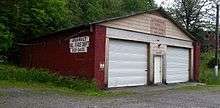
 Jenkinjones Road in Anawalt | |
 Location of Anawalt in McDowell County, West Virginia. | |
 Anawalt, West Virginia Location of Anawalt in McDowell County, West Virginia.  Anawalt, West Virginia Anawalt, West Virginia (the US) | |
| Coordinates: 37°20′11″N 81°26′26″W / 37.33639°N 81.44056°WCoordinates: 37°20′11″N 81°26′26″W / 37.33639°N 81.44056°W | |
| Country | United States |
| State | West Virginia |
| County | McDowell |
| Government | |
| • Mayor | Dorothy Brown |
| Area[1] | |
| • Total | 0.57 sq mi (1.48 km2) |
| • Land | 0.57 sq mi (1.48 km2) |
| • Water | 0 sq mi (0 km2) |
| Elevation | 1,706 ft (520 m) |
| Population (2010)[2] | |
| • Total | 226 |
| • Estimate (2016)[3] | 202 |
| • Density | 396.5/sq mi (153.1/km2) |
| Time zone | UTC-5 (Eastern (EST)) |
| • Summer (DST) | UTC-4 (EDT) |
| ZIP code | 24808 |
| Area code(s) | 304 |
| FIPS code | 54-01780[4] |
| GNIS feature ID | 2390703[5] |
Anawalt is a town in McDowell County, West Virginia, United States. At one time it was known as Jeanette.[5] The population was 226 at the 2010 census.[2] Coal mining was the town's chief industry.
Geography
According to the United States Census Bureau, the town has a total area of 0.57 square miles (1.48 km2), all of it land.[1]
Demographics
| Historical population | |||
|---|---|---|---|
| Census | Pop. | %± | |
| 1950 | 1,383 | — | |
| 1960 | 1,062 | −23.2% | |
| 1970 | 801 | −24.6% | |
| 1980 | 652 | −18.6% | |
| 1990 | 329 | −49.5% | |
| 2000 | 272 | −17.3% | |
| 2010 | 226 | −16.9% | |
| Est. 2016 | 202 | [3] | −10.6% |
| U.S. Decennial Census[6] 2015 Estimate[7] | |||
2010 census
As of the census[2] of 2010, there were 226 people, 91 households, and 62 families residing in the town. The population density was 396.5 inhabitants per square mile (153.1/km2). There were 135 housing units at an average density of 236.8 per square mile (91.4/km2). The racial makeup of the town was 88.9% White, 9.3% African American, and 1.8% from two or more races. Hispanic or Latino of any race were 0.4% of the population.
There were 91 households of which 31.9% had children under the age of 18 living with them, 41.8% were married couples living together, 19.8% had a female householder with no husband present, 6.6% had a male householder with no wife present, and 31.9% were non-families. 29.7% of all households were made up of individuals and 15.4% had someone living alone who was 65 years of age or older. The average household size was 2.48 and the average family size was 2.97.
The median age in the town was 44.3 years. 20.4% of residents were under the age of 18; 8.9% were between the ages of 18 and 24; 23% were from 25 to 44; 32.4% were from 45 to 64; and 15.5% were 65 years of age or older. The gender makeup of the town was 47.8% male and 52.2% female.
2000 census
As of the census[4] of 2000, there were 272 people, 114 households, and 77 families residing in the town. The population density was 418.4 inhabitants per square mile (161.5/km2). There were 148 housing units at an average density of 227.7 per square mile (87.9/km2). The racial makeup of the town was 90.44% White, 9.19% African American, and 0.37% from two or more races.
There were 114 households out of which 25.4% had children under the age of 18 living with them, 50.0% were married couples living together, 12.3% had a female householder with no husband present, and 31.6% were non-families. 28.9% of all households were made up of individuals and 18.4% had someone living alone who was 65 years of age or older. The average household size was 2.39 and the average family size was 2.91.
In the town, the population was spread out with 21.0% under the age of 18, 7.4% from 18 to 24, 28.7% from 25 to 44, 26.8% from 45 to 64, and 16.2% who were 65 years of age or older. The median age was 42 years. For every 100 females, there were 83.8 males. For every 100 females age 18 and over, there were 83.8 males.
The median income for a household in the town was $13,333, and the median income for a family was $17,321. Males had a median income of $30,938 versus $14,375 for females. The per capita income for the town was $8,953. About 37.3% of families and 37.0% of the population were below the poverty line, including 35.6% of those under the age of eighteen and 28.3% of those sixty five or over.
References
- 1 2 "US Gazetteer files 2010". United States Census Bureau. Archived from the original on 2012-01-24. Retrieved 2013-01-24.
- 1 2 3 "American FactFinder". United States Census Bureau. Retrieved 2013-01-24.
- 1 2 "Population and Housing Unit Estimates". Retrieved June 9, 2017.
- 1 2 "American FactFinder". United States Census Bureau. Archived from the original on 2013-09-11. Retrieved 2008-01-31.
- 1 2 "US Board on Geographic Names". United States Geological Survey. 2007-10-25. Retrieved 2008-01-31.
- ↑ "U.S. Decennial Census". Census.gov. Archived from the original on May 12, 2015. Retrieved June 11, 2013.
- ↑ "Population Estimates". United States Census Bureau. Retrieved May 23, 2016.
Municipalities and communities of McDowell County, West Virginia, United States | ||
|---|---|---|
| Cities | 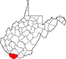 | |
| Towns | ||
| CDPs | ||
| Unincorporated communities |
| |
| Ghost town | ||
| Footnotes | ‡This populated place also has portions in an adjacent county or counties | |