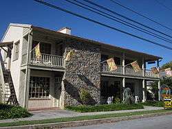
Bolivar, West Virginia
| Bolivar, West Virginia | |
|---|---|
| Town | |
| Corporation of Bolivar | |
 | |
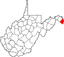
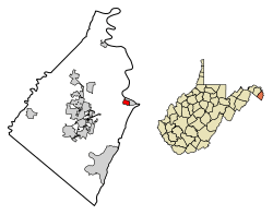 Location of Bolivar in Jefferson County, West Virginia. | |
 Bolivar, West Virginia Location of Bolivar in Jefferson County, West Virginia.  Bolivar, West Virginia Bolivar, West Virginia (West Virginia)  Bolivar, West Virginia Bolivar, West Virginia (the US) | |
| Coordinates: 39°19.4′N 77°45.1′W / 39.3233°N 77.7517°WCoordinates: 39°19.4′N 77°45.1′W / 39.3233°N 77.7517°W | |
| Country | United States |
| State | West Virginia |
| County | Jefferson |
| Government | |
| • Mayor | Helen Dettmer |
| • Recorder | P. Jean Reed |
| Area[1] | |
| • Total | 0.44 sq mi (1.14 km2) |
| • Land | 0.44 sq mi (1.14 km2) |
| • Water | 0 sq mi (0 km2) |
| Elevation | 499 ft (152 m) |
| Population (2010)[2] | |
| • Total | 1,045 |
| • Estimate (2016)[3] | 1,046 |
| • Density | 2,375.0/sq mi (917.0/km2) |
| Time zone | UTC-5 (EST) |
| • Summer (DST) | UTC-4 (EDT) |
| Area code(s) | 304 |
| FIPS code | 54-08932[4] |
| GNIS feature ID | 1556734[5] |
| Website | http://www.bolivarwv.org/ |
Bolivar (/ˈbɒlɪvər/ rhymes with Oliver) is a town in Jefferson County in the U.S. state of West Virginia's Eastern Panhandle. The population was 1,045 at the 2000 census and was exactly the same number in the 2010 census. The citizens of Bolivar chose to name their town for the South American revolutionary leader, Simón Bolívar (July 24, 1783 – December 17, 1830).[6]
Bolivar and the adjoining town of Harpers Ferry, though legally two distinct municipalities, together form one large town. The Appalachian Trail passes directly through Harpers Ferry, which some consider the psychological midpoint of the trail,[7][8] although the physical midpoint is further north, in Pennsylvania. Uniquely, the towns of Harpers Ferry and Bolivar partnered with the ATC to be declared a united Appalachian Trail Community.[9]
Geography
Bolivar is located at 39°19.4′N 77°45.1′W / 39.3233°N 77.7517°W (39.3241, -77.7515).[10] It is contiguous with, and immediately up-hill from, the famous historic town Harpers Ferry
According to the United States Census Bureau, the town has a total area of 0.44 square miles (1.14 km2), all of it land.[1]
Demographics
| Historical population | |||
|---|---|---|---|
| Census | Pop. | %± | |
| 1850 | 1,054 | — | |
| 1860 | 1,130 | 7.2% | |
| 1880 | 822 | — | |
| 1890 | 804 | −2.2% | |
| 1900 | 781 | −2.9% | |
| 1910 | 687 | −12.0% | |
| 1920 | 585 | −14.8% | |
| 1930 | 616 | 5.3% | |
| 1940 | 628 | 1.9% | |
| 1950 | 637 | 1.4% | |
| 1960 | 754 | 18.4% | |
| 1970 | 943 | 25.1% | |
| 1980 | 672 | −28.7% | |
| 1990 | 1,013 | 50.7% | |
| 2000 | 1,045 | 3.2% | |
| 2010 | 1,045 | 0.0% | |
| Est. 2016 | 1,046 | [3] | 0.1% |
| U.S. Decennial Census[11] | |||
2010 census
As of the census[2] of 2010, there were 1,045 people, 498 households, and 266 families residing in the town. The population density was 2,375.0 inhabitants per square mile (917.0/km2). There were 565 housing units at an average density of 1,284.1 per square mile (495.8/km2). The racial makeup of the town was 93.4% White, 4.5% African American, 0.2% Native American, 0.3% Asian, 0.3% from other races, and 1.3% from two or more races. Hispanic or Latino of any race were 1.3% of the population.
There were 498 households of which 23.5% had children under the age of 18 living with them, 40.8% were married couples living together, 9.0% had a female householder with no husband present, 3.6% had a male householder with no wife present, and 46.6% were non-families. 40.4% of all households were made up of individuals and 15.6% had someone living alone who was 65 years of age or older. The average household size was 2.10 and the average family size was 2.81.
The median age in the town was 43.7 years. 17.5% of residents were under the age of 18; 8.3% were between the ages of 18 and 24; 25.5% were from 25 to 44; 32.5% were from 45 to 64; and 16.1% were 65 years of age or older. The gender makeup of the town was 46.1% male and 53.9% female.
2000 census
As of the census[4] of 2000, there were 1,045 people, 479 households, and 274 families residing in the town. The population density was 2,141.1 inhabitants per square mile (823.4/km²). There were 519 housing units at an average density of 1,063.4 per square mile (409.0/km²). The racial makeup of the town was 91.10% White, 5.36% African American, 0.67% Native American, 0.48% Asian, 0.19% Pacific Islander, 0.48% from other races, and 1.72% from two or more races. Hispanic or Latino of any race were 1.63% of the population.
There were 479 households out of which 23.4% had children under the age of 18 living with them, 43.6% were married couples living together, 10.4% had a female householder with no husband present, and 42.6% were non-families. 35.3% of all households were made up of individuals and 13.2% had someone living alone who was 65 years of age or older. The average household size was 2.18 and the average family size was 2.83.
In the town, the population was spread out with 20.8% under the age of 18, 7.7% from 18 to 24, 30.0% from 25 to 44, 25.0% from 45 to 64, and 16.6% who were 65 years of age or older. The median age was 39 years. For every 100 females, there were 90.3 males. For every 100 females age 18 and over, there were 92.6 males.
The median income for a household in the town was $42,375, and the median income for a family was $47,375. Males had a median income of $36,667 versus $25,500 for females. The per capita income for the town was $20,969. About 8.1% of families and 12.5% of the population were below the poverty line, including 14.3% of those under age 18 and 16.4% of those age 65 or over.
References
- 1 2 "US Gazetteer files 2010". United States Census Bureau. Archived from the original on 2012-01-24. Retrieved 2013-01-24.
- 1 2 "American FactFinder". United States Census Bureau. Retrieved 2013-01-24.
- 1 2 "Population and Housing Unit Estimates". Retrieved June 9, 2017.
- 1 2 "American FactFinder". United States Census Bureau. Archived from the original on 2013-09-11. Retrieved 2008-01-31.
- ↑ "US Board on Geographic Names". United States Geological Survey. 2007-10-25. Retrieved 2008-01-31.
- ↑ Kenny, Hamill (1945). West Virginia Place Names: Their Origin and Meaning, Including the Nomenclature of the Streams and Mountains. Piedmont, WV: The Place Name Press. p. 123.
- ↑ "Hikes - Harpers Ferry National Historical Park (U.S. National Park Service)". www.nps.gov. Archived from the original on 4 October 2017. Retrieved 28 April 2018.
- ↑ "Headquarters and psychological mid-point of the Appalachian Trail, Harpers Ferry, West Virginia". loc.gov. Archived from the original on 21 September 2017. Retrieved 28 April 2018.
- ↑ "Harper's Ferry & Bolivar, West Virginia: An Appalachian Trail Community". Appalachian Trail Conservancy. Retrieved 2018-05-24.
- ↑ "US Gazetteer files: 2010, 2000, and 1990". United States Census Bureau. 2011-02-12. Retrieved 2011-04-23.
- ↑ "Census of Population and Housing". Census.gov. Archived from the original on May 12, 2015. Retrieved June 4, 2015.