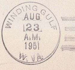
Winding Gulf, West Virginia
| Winding Gulf, West Virginia | |
|---|---|
| Unincorporated community | |
 Winding Gulf, West Virginia  Winding Gulf, West Virginia | |
| Coordinates: 37°40′41″N 81°14′23″W / 37.67806°N 81.23972°WCoordinates: 37°40′41″N 81°14′23″W / 37.67806°N 81.23972°W | |
| Country | United States |
| State | West Virginia |
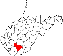
| County | Raleigh |
| Elevation | 2,264 ft (690 m) |
| Time zone | UTC-5 (Eastern (EST)) |
| • Summer (DST) | UTC-4 (EDT) |
| Area code(s) | 304 & 681 |
| GNIS feature ID | 1556003[1] |
Winding Gulf is an unincorporated community in Raleigh County, West Virginia, United States. Winding Gulf is located on Winding Gulf south of Sophia.[2]
History
Justis Collins (Coal Baron) built coal camps in Winding Gulf in 1910. There were over 50 miners died in the mines at Winding Gulf over the years. The mines were serviced by the Virginian Railroad. There were several collieries in Winding Gulf such as, No. 1 camp, No. 2 camp, Lynwynn camp, Epperly Hill, and Farley Hill. Winding Gulf was the third largest town in Raleigh County in the 1920s.[3] Mining in Winding Gulf lasted into the late 1980s.[4]
References
- ↑ "US Board on Geographic Names". United States Geological Survey. 2007-10-25. Retrieved 2008-01-31.
- ↑ Raleigh County, West Virginia General Highway Map (PDF) (Map). West Virginia Department of Transportation. 2011. p. 4. Retrieved December 12, 2011.
- ↑ http://www.coalcampusa.com/sowv/gulf/winding_gulf/winding_gulf.htm
- ↑ http://www.coalcampusa.com/sowv/gulf/gulf.htm
This article is issued from
Wikipedia.
The text is licensed under Creative Commons - Attribution - Sharealike.
Additional terms may apply for the media files.