Stonecoal Junction, West Virginia
| Stonecoal Junction, West Virginia | |
|---|---|
| Unincorporated community | |
 Stonecoal Junction, West Virginia  Stonecoal Junction, West Virginia | |
| Coordinates: 37°36′11″N 81°18′48″W / 37.60306°N 81.31333°WCoordinates: 37°36′11″N 81°18′48″W / 37.60306°N 81.31333°W | |
| Country | United States |
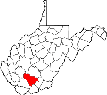
| State | West Virginia |
| County | Raleigh |
| Elevation | 1,614 ft (492 m) |
| Time zone | UTC-5 (Eastern (EST)) |
| • Summer (DST) | UTC-4 (EDT) |
| Area code(s) | 304 & 681 |
| GNIS feature ID | 1555717[1] |
Stonecoal Junction (also called Stonecoal) is an unincorporated community in Raleigh County, West Virginia, United States. Stonecoal Junction is located on County Route 33 at the confluence of Winding Gulf and Stonecoal Creek, 0.6 miles (0.97 km) southwest of Rhodell.[2]
References
- ↑ U.S. Geological Survey Geographic Names Information System: Stonecoal Junction, West Virginia
- ↑ Raleigh County, West Virginia General Highway Map (PDF) (Map). West Virginia Department of Transportation. 2011. p. 3. Archived from the original (PDF) on 2012-04-25. Retrieved December 12, 2011.
This article is issued from
Wikipedia.
The text is licensed under Creative Commons - Attribution - Sharealike.
Additional terms may apply for the media files.