Equator

An equator of a rotating spheroid (such as a planet) is its zeroth circle of latitude (parallel). It is the imaginary line on the spheroid's surface, equidistant from its poles, dividing it into northern and southern hemispheres. In other words, it is the intersection of the spheroid's surface with the plane perpendicular to its axis of rotation and midway between its poles.
On Earth, the Equator is about 40,075 kilometres (24,901 mi) long, of which 78.8% lies across water and 21.3% over land. Indonesia is the country with the longest equatorial line lay across the water and land.
Etymology
The name is derived from medieval Latin aequator, in the phrase circulus aequator diei et noctis ‘circle equalizing day and night’, from Latin aequare ‘make equal’.[1]
Overview
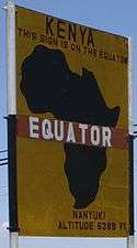
Right: Road sign marking the Equator near Nanyuki, Kenya
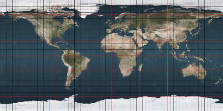
The latitude of the Earth's equator is, by definition, 0° (zero degrees) of arc. The Equator is one of the five notable circles of latitude on Earth; the other four are the two Polar Circles (the Arctic Circle and the Antarctic Circle) and the two Tropical Circles (the Tropic of Cancer and the Tropic of Capricorn). The Equator is the only line of latitude which is also a great circle — that is, one whose plane passes through the center of the globe. The plane of Earth's equator, when projected outwards to the celestial sphere, defines the celestial equator.
In the cycle of Earth's seasons, the plane of the equator passes through the Sun twice per year: at the March and September equinoxes. To a person on the Earth, the Sun appears to travel North or South over the Equator (or the celestial equator) at these times. Light rays from the center of the Sun are perpendicular to the surface of the Earth at the point of solar noon on the Equator.
Locations on the Equator experience the quickest sunrises and sunsets, because the sun moves nearly perpendicular to the horizon for most of the year. The length of daylight (sunrise to sunset) is almost constant throughout the year; it is about fourteen minutes longer than nighttime due to atmospheric refraction and the fact that sunrise is begun (or sunset is ended) as the upper edge, not the center, of the Sun's disk crosses the horizon.
The Earth bulges slightly at the Equator; the "average" diameter of the Earth is 12,750 kilometres (7,922 mi), but the diameter at the Equator is about 43 kilometres (27 mi) greater than at the poles.[2]
Sites near the Equator, such as the Guiana Space Centre in Kourou, French Guiana, are good locations for spaceports as they have a faster rotational speed than other latitudes; the added velocity reduces the fuel needed to launch spacecraft. Because the Earth spins to the east, spacecraft must also launch to the east (or to the southeast or northeast) to take advantage of this Earth-boost of speed.
Geodesy
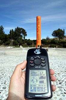
Precise location
The precise location of the Equator is not truly fixed; the true equatorial plane is perpendicular to the Earth's spin axis, which drifts about 9 metres (30 ft) during a year. This effect must be accounted for in detailed geophysical measurements.
Exact length
In two widely used geodetic standards, the Equator is modelled as a circle whose radius is a whole number of metres. In 1976 the IAU chose a radius of 6,378.140 kilometres (3,963.192 mi) (codified as the IAU-1976 value), later refined by the IUGG to 6,378.137 kilometres (3,963.191 mi) and adopted in WGS-84. Despite this change, the yet more recent IAU-2000 retained the old IAU-1976 value. If it were really circular, the length of the Equator would be exactly 2π times the radius, namely 40,075.036 kilometres (24,901.473 mi). However, due to the effect of the tides on the Earth's surface the actual circumference at the equator is about 40,075.16 kilometres (24,901.55 mi).
The geographical mile is defined as one arc minute of the Equator, so it has different values depending on which radius is assumed. For example, by WSG-84, the distance is 1,855.3248 metres (6,087.024 ft), while by IAU-2000, it is 1,855.3257 metres (6,087.027 ft). This is a difference of less than one millimeter over the total distance (approximately 1.86 kilometres (1.16 mi)).
The earth is commonly modeled as a sphere flattened 0.336% along its axis. This makes the Equator 0.16% longer than a meridian (a great circle passing through the two poles). The IUGG standard meridian is, to the nearest millimetre, 40,007.862917 kilometres (24,859.733480 mi), one arc minute of which is 1,852.216 metres (6,076.82 ft), explaining the SI standardization of the nautical mile as 1,852 metres (6,076 ft), more than 3 metres (9.8 ft) less than the geographical mile.
The sea-level surface of the Earth (the geoid) is irregular, so the actual length of the Equator is not so easy to determine. Aviation Week and Space Technology on 9 October 1961 reported that measurements using the Transit IV-A satellite had shown the equatorial "diameter" from longitude 11° West to 169° East to be 1,000 feet (300 m) greater than its "diameter" ninety degrees away.
Crossing-the-Equator ceremonies
Certain navies, such as the Royal Navy, Russian Navy, and US Navy, have a tradition of holding ceremonies aboard ships to mark sailors' first crossing of the Equator. These ceremonial events have in the past been notorious for their brutality. Milder line-crossing ceremonies, typically featuring King Neptune, are also held for passengers' entertainment on some civilian ocean liners and cruise ships.
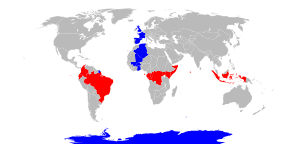
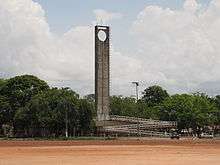
Equatorial countries and territories
The Equator passes through the land of 11 countries. Starting at the Prime Meridian and heading eastwards, the Equator passes through:
Despite its name, no part of Equatorial Guinea lies on the Equator. However, its island of Annobón is 155 km (96 mi) south of the Equator, and the rest of the country lies to the north.
Equatorial seasons and climate

Seasons result from the tilt of the Earth's axis compared to the plane of its revolution around the Sun. Throughout the year the northern and southern hemispheres are alternately turned either toward or away from the sun depending on Earth's position in its orbit. The hemisphere turned toward the sun receives more sunlight and is in summer, while the other hemisphere receives less sun and is in winter (see solstice).
At the equinoxes, the Earth's axis is perpendicular to the sun rather than tilted toward or away, meaning that day and night are both about 12 hours long across the whole of the Earth.
The Equator lies mostly on the three largest oceans: the Atlantic Ocean, the Indian Ocean, and the Pacific Ocean. Near the Equator there is little temperature change throughout the year, though there may be dramatic differences in rainfall and humidity. The terms summer, autumn, winter and spring do not generally apply. Lowlands around the Equator generally have a tropical rainforest climate, also known as an equatorial climate, though cold currents cause some regions to have tropical monsoon climates with a dry season in the middle of the year, and the Somali Current generated by the Asian monsoon due to continental heating via the high Tibetan Plateau causes Greater Somalia to have an arid climate despite its equatorial location.
Average annual temperatures in equatorial lowlands are around 31 °C (88 °F) during the afternoon and 23 °C (73 °F) around sunrise. Rainfall is very high away from cold current upwelling zones, from 2,500 to 3,500 mm (100 to 140 in) per year. There are about 200 rainy days per year and average annual sunshine hours are around 2,000. Despite high year-round sea level temperatures, some higher altitudes such as the Andes and Mount Kilimanjaro have glaciers. The highest point on the Equator is at the elevation of 4,690 metres (15,387 ft), at 0°0′0″N 77°59′31″W / 0.00000°N 77.99194°W, found on the southern slopes of Volcán Cayambe [summit 5,790 metres (18,996 ft)] in Ecuador. This is slightly above the snow line and is the only place on the Equator where snow lies on the ground. At the Equator the snow line is around 1,000 metres (3,300 ft) lower than on Mount Everest and as much as 2,000 metres (6,600 ft) lower than the highest snow line in the world, near the Tropic of Capricorn on Llullaillaco.
| Climate data for Macapá, Brazil in South America | |||||||||||||
|---|---|---|---|---|---|---|---|---|---|---|---|---|---|
| Month | Jan | Feb | Mar | Apr | May | Jun | Jul | Aug | Sep | Oct | Nov | Dec | Year |
| Average high °C (°F) | 29.7 (85.5) |
29.2 (84.6) |
29.3 (84.7) |
29.5 (85.1) |
30.0 (86) |
30.3 (86.5) |
30.6 (87.1) |
31.5 (88.7) |
32.1 (89.8) |
32.6 (90.7) |
32.3 (90.1) |
31.4 (88.5) |
30.71 (87.28) |
| Daily mean °C (°F) | 26.4 (79.5) |
26.2 (79.2) |
26.3 (79.3) |
26.5 (79.7) |
26.8 (80.2) |
26.8 (80.2) |
26.8 (80.2) |
27.4 (81.3) |
27.8 (82) |
28.1 (82.6) |
27.9 (82.2) |
27.4 (81.3) |
27.03 (80.65) |
| Average low °C (°F) | 23.0 (73.4) |
23.1 (73.6) |
23.2 (73.8) |
23.5 (74.3) |
23.5 (74.3) |
23.2 (73.8) |
22.9 (73.2) |
23.3 (73.9) |
23.4 (74.1) |
23.5 (74.3) |
23.5 (74.3) |
23.4 (74.1) |
23.29 (73.92) |
| Average rainfall mm (inches) | 299.6 (11.795) |
347.0 (13.661) |
407.2 (16.031) |
384.3 (15.13) |
351.5 (13.839) |
220.1 (8.665) |
184.8 (7.276) |
98.00 (3.8583) |
42.60 (1.6772) |
35.50 (1.3976) |
58.40 (2.2992) |
142.5 (5.61) |
2,571.5 (101.2393) |
| Average rainy days (≥ 0.1 mm) | 23 | 22 | 24 | 24 | 25 | 22 | 19 | 13 | 6 | 5 | 6 | 14 | 203 |
| Mean monthly sunshine hours | 148.8 | 113.1 | 108.5 | 114.0 | 151.9 | 189.0 | 226.3 | 272.8 | 273.0 | 282.1 | 252.0 | 204.6 | 2,336.1 |
| Source: World Meteorological Organization (UN),[4] Hong Kong Observatory[5] | |||||||||||||
| Climate data for Pontianak, Indonesia in Asia | |||||||||||||
|---|---|---|---|---|---|---|---|---|---|---|---|---|---|
| Month | Jan | Feb | Mar | Apr | May | Jun | Jul | Aug | Sep | Oct | Nov | Dec | Year |
| Average high °C (°F) | 32.4 (90.3) |
32.7 (90.9) |
32.9 (91.2) |
33.2 (91.8) |
33.0 (91.4) |
33.2 (91.8) |
32.9 (91.2) |
33.4 (92.1) |
32.6 (90.7) |
32.6 (90.7) |
32.2 (90) |
32.0 (89.6) |
32.7 (90.9) |
| Daily mean °C (°F) | 27.6 (81.7) |
27.7 (81.9) |
28.0 (82.4) |
28.2 (82.8) |
28.2 (82.8) |
28.2 (82.8) |
27.7 (81.9) |
27.9 (82.2) |
27.6 (81.7) |
27.7 (81.9) |
27.4 (81.3) |
27.2 (81) |
27.7 (81.9) |
| Average low °C (°F) | 22.7 (72.9) |
22.6 (72.7) |
23.0 (73.4) |
23.2 (73.8) |
23.4 (74.1) |
23.1 (73.6) |
22.5 (72.5) |
22.3 (72.1) |
22.6 (72.7) |
22.8 (73) |
22.6 (72.7) |
22.4 (72.3) |
22.7 (72.9) |
| Average rainfall mm (inches) | 260 (10.24) |
215 (8.46) |
254 (10) |
292 (11.5) |
256 (10.08) |
212 (8.35) |
201 (7.91) |
180 (7.09) |
295 (11.61) |
329 (12.95) |
400 (15.75) |
302 (11.89) |
3,196 (125.83) |
| Average rainy days (≥ 0.1 mm) | 15 | 13 | 21 | 22 | 20 | 18 | 16 | 25 | 14 | 27 | 25 | 22 | 238 |
| Source: World Meteorological Organization (UN)[6] | |||||||||||||
| Climate data for Libreville, Gabon in Africa | |||||||||||||
|---|---|---|---|---|---|---|---|---|---|---|---|---|---|
| Month | Jan | Feb | Mar | Apr | May | Jun | Jul | Aug | Sep | Oct | Nov | Dec | Year |
| Average high °C (°F) | 29.5 (85.1) |
30.0 (86) |
30.2 (86.4) |
30.1 (86.2) |
29.4 (84.9) |
27.6 (81.7) |
26.4 (79.5) |
26.8 (80.2) |
27.5 (81.5) |
28.0 (82.4) |
28.4 (83.1) |
29.0 (84.2) |
28.58 (83.44) |
| Daily mean °C (°F) | 26.8 (80.2) |
27.0 (80.6) |
27.1 (80.8) |
26.6 (79.9) |
26.7 (80.1) |
25.4 (77.7) |
24.3 (75.7) |
24.3 (75.7) |
25.4 (77.7) |
25.7 (78.3) |
25.9 (78.6) |
26.2 (79.2) |
25.95 (78.71) |
| Average low °C (°F) | 24.1 (75.4) |
24.0 (75.2) |
23.9 (75) |
23.1 (73.6) |
24.0 (75.2) |
23.2 (73.8) |
22.1 (71.8) |
21.8 (71.2) |
23.2 (73.8) |
23.4 (74.1) |
23.4 (74.1) |
23.4 (74.1) |
23.30 (73.94) |
| Average rainfall mm (inches) | 250.3 (9.854) |
243.1 (9.571) |
363.2 (14.299) |
339.0 (13.346) |
247.3 (9.736) |
54.10 (2.1299) |
6.600 (0.25984) |
13.70 (0.5394) |
104.0 (4.094) |
427.2 (16.819) |
490.0 (19.291) |
303.2 (11.937) |
2,841.7 (111.87614) |
| Average rainy days (≥ 0.1 mm) | 17.9 | 14.8 | 19.5 | 19.2 | 16.0 | 3.70 | 1.70 | 4.90 | 14.5 | 25.0 | 22.6 | 17.6 | 177.4 |
| Mean monthly sunshine hours | 176.7 | 182.7 | 176.7 | 177.0 | 158.1 | 132.0 | 117.8 | 89.90 | 96.00 | 111.6 | 135.0 | 167.4 | 1,720.9 |
| Source: World Meteorological Organization (UN),[7] Hong Kong Observatory[8] | |||||||||||||
See also
References
- ↑ "Definition of equator". OxfordDictionaries.com. Retrieved 5 May 2018.
- ↑ "Equator". National Geographic - Education. Retrieved 29 May 2013.
- ↑ Instituto Geográfico Militar de Ecuador (24 January 2005). "Memoria Técnica de la Determinación de la Latitud Cero" (in Spanish).
- ↑ "Weather Information for Macapa".
- ↑ Climatological Information for Macapa, Brazil - Hong Kong Observatory
- ↑ "Weather Information for Pontianak".
- ↑ "Weather Information for Libreville".
- ↑ Climatological Information for Libreville, Gabon - Hong Kong Observatory
Sources
| Wikimedia Commons has media related to Equator. |
- Moritz, H (September 1980). "Geodetic Reference System 1980". Bulletin Géodésique. Berlin: Springer-Verlag. 54 (3): 395–405. Bibcode:1980BGeod..54..395M. doi:10.1007/BF02521480. (IUGG/WGS-84 data)
- Taff, Laurence G (1981). Computational Spherical Astronomy. New York: Wiley. ISBN 0-471-06257-X. OCLC 6532537. (IAU data)
 |