Guimaras
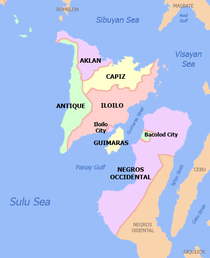
Guimaras [ɡimaˈɾas] (Hiligaynon: Kapuoran sang Guimaras; Kinaray-a: Probinsiya kang Guimaras; Tagalog: Lalawigan ng Guimaras) is an island province in the Philippines located in the region of Western Visayas. Among the smallest provinces, its capital is Jordan. The province is situated in the Panay Gulf, between the islands of Panay and Negros. To the northwest is the province of Iloilo and to the southeast is Negros Occidental. The whole island is part of the Metro Iloilo-Guimaras, one of the twelve metropolitan areas of the Philippines.
Guimaras | |
|---|---|
| Province of Guimaras | |
 Flag  Seal | |
| Nickname(s): Mango Capital of the Philippines | |
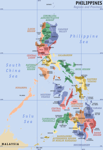
 Location in the Philippines | |
| |
| Coordinates: 10°34′N 122°35′E | |
| Country | Philippines |
| Region | Western Visayas (Region VI) |
| Founded | May 22, 1581 |
| Capital | Jordan |
| Government | |
| • Type | Sangguniang Panlalawigan |
| • Congresswoman | Ma.Lucille Nava (LP) |
| • Governor | Samuel T. Gumarin (PDP-LABAN) |
| • Vice Governor | John Edward G. Gando (LP) |
| Area | |
| • Total | 604.57 km2 (233.43 sq mi) |
| Area rank | 77th out of 81 |
| Highest elevation (Mount Dinulman) | 267 m (876 ft) |
| Population (2015 census)[2] | |
| • Total | 174,613 |
| • Rank | 74th out of 81 |
| • Density | 290/km2 (750/sq mi) |
| • Density rank | 28th out of 81 |
| Divisions | |
| • Independent cities | 0 |
| • Component cities | 0 |
| • Municipalities | |
| • Barangays | 98 |
| • Districts | Lone district of Guimaras |
| Time zone | UTC+8 (PHT) |
| ZIP code | 5044–5048 |
| IDD : area code | +63 (0)33 |
| ISO 3166 code | PH |
| Spoken languages |
|
| Income classification | 4th class |
| Website | guimaras |
The province consists primarily of Guimaras Island, and also includes Inampulugan, Guiwanon (or Guiuanon), Panobolon, Natunga, Nadulao, and many surrounding islets.[3] Geologists have concluded that the island once formed one landmass with Panay.
Guimaras, formerly known as Himal-us, was a sub-province of Iloilo until it was made an independent province on May 22, 1992.
History
Spanish era
About 1581, Gonzalo Ronquillo de Peñalosa, Spanish governor and Captain-General of the Philippine Islands, established a settlement in Guimaras for the purpose of Christianizing the island's natives. He and his subordinates organized the pueblicitos or villages of Nayup under the patronage of Saint Peter the Apostle, and Igang with Saint Anne as patroness.
Evangelization of Guimaras occurred around the same time the friars were making inroads in Panay. The Augustinians established the visitas (chapelries) of Nayup and Igang as subordinate to Oton, Iloilo. Gómez Pérez Dasmariñas, the 7th Spanish Governor-General, noted in a 20 June 1591 report to King Philip II that the friars of Oton made regular visits to the island.
In 1742, the island came under the jurisdiction of Dumangas – now known as Iloilo, until 1751 when the Augustinian Order was replaced by the Jesuits, after which the Dominican order took over Guimaras. The Jesuits, who had established a school in Iloilo and had missions in Molo and Arevalo, took charge of the island. By 1755, it was organized into a regular parish. When the population increased considerably, the island was given its municipal status with a seat of government at Tilad (today Buenavista)
In 2019, a tragic event occurred, three motor bancas was flipped due to strong winds and waves. Some didn't make it. A similar accident happened years ago in 2015 where also a motor banca was flipped due to the same reason.
American era
Under American rule, the Guimarasnons were given the opportunity to elect their municipal president in 1908.[4]
Douglas MacArthur, a fresh graduate from West Point as a Second Lieutenant at the age of 23, came to Iloilo as the head of the company of U.S. Army Corps of Engineers. They constructed roads and the Santo Rosario Wharf, presently named MacArthur's Wharf, which are still in use today. In November 1903, while working on Guimaras, he was ambushed by a pair of Filipino brigands or guerrillas; he shot and killed both with his pistol.[5]
In 1942, Japanese Imperial forces landed on Guimaras Island as the Empire of Japan began its occupation of the country during the Second World War.
In 1945, the combined United States and Philippine Commonwealth forces landed on Guimaras Island, attacking the Japanese and defeating them in the Battle of Guimaras, which led to the liberation of the island.[6]
Provincial status
Guimaras gained its status as a sub-province of Iloilo through Republic Act 4667,[7] which was enacted by Congress on 18 June 1966. It was proclaimed as a regular and full-fledged province on 22 May 1992 after a plebiscite was conducted to ratify the approval of its conversion pursuant to Section 462 of R.A. 7160.[8]
Shortly after Guimaras acquired its provincial status, President Fidel V. Ramos appointed Emily Relucio-López as its first Governor.
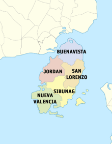
The province of Guimaras was originally composed of three municipalities: Buenavista, Jordan, and Nueva Valencia. In 1995, through Republic Act No. 7896 and Republic Act No. 7897,[9][10] the municipalities of Sibunag and San Lorenzo were created. The two new municipalities officially acquired their municipal status after the May 8, 1995 plebiscite held simultaneously with the local election.
Ernesto L. Gedalanga was the first appointed mayor of Sibunag and Arsenio Zambarrano was also appointed mayor of San Lorenzo. The temporary seat of government of the Municipality of Sibunag is at Barangay Dasal while the temporary seat of Government of the Municipality of San Lorenzo is at Barangay Cabano.
Guimaras oil spill
In August 2006, the Guimaras oil spill occurred. The 998-ton MT Solar 1, chartered by Petron (the Philippines' largest oil refiner), carrying 2.4 million litres of bunker fuel, sank 17 kilometres (11 mi) off the island's southern coast, contaminating 24 square kilometres (9.3 sq mi). The Philippine Coast Guard called this the worst oil spill in the country's history. According to officials, 1,100 hectares (2,700 acres) of mangroves were affected, including parts of the Taklong Island National Marine Reserve.[11]
Geography
Guimaras comprises primarily of Guimaras Island, and the minor islets of Inampulugan, Guiwanon (or Guiuanon), Panobolon, Natunga, Nadulao and many more. The province covers a total area of 604.57 square kilometres (233.43 sq mi)[12] occupying the southeastern section of the Western Visayas region.
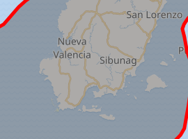
The province has 5 municipalities. There is only one legislative district of Guimaras which encompasses all five towns.
|
| |||||||||||||||||||||||||||||||||||||||||||||||||||||||||||||||||||||||||||||||||||||||||||||||||||||||||||||||||||||||||
Demographics
| Population census of Guimaras | |||||||||||||||||||||||||
|---|---|---|---|---|---|---|---|---|---|---|---|---|---|---|---|---|---|---|---|---|---|---|---|---|---|
|
| ||||||||||||||||||||||||
| Source: Philippine Statistics Authority[2][13][13] | |||||||||||||||||||||||||
The population of Guimaras in the 2015 census was 174,613 people,[2] with a density of 290 inhabitants per square kilometre or 750 inhabitants per square mile.
The people of the province, called Guimarasnon, speak Hiligaynon and Kinaray-a as the primary languages, as it was once a sub-province of Iloilo. Filipino and English are widely spoken and understood.
Economy

The province is basically agricultural with mangoes, palay, coconuts, livestock, poultry and fishing as major products. Its major industries are tourism, fruit processing, coconut processing, fish farming, handicrafts making, mining, quarrying and lime production.

Guimaras is well known for its agricultural crops, particularly the mangoes, where some +50,000 of these trees are planted. The island province is famous for producing one of the sweetest mangoes in the world, thus earning the nickname "Mango Capital of the Philippines" from local and foreign tourists. Guimaras mangoes are reportedly served at the White House and Buckingham Palace.[14][15][16] Guimaras' largest event of the year is the Manggahan Festival (the Mango Festival).[17] The variety of mangoes produced are also best for making dried mangoes, jam and other special delicacies.
Transportation
Located southeast of Panay, Guimaras is separated from Iloilo by the Iloilo Strait, a narrow channel which takes about twenty to twenty-five minutes to cross by pump boat from Ortiz in Iloilo City to Jordan, Guimaras. Other ferries leave from the Parola wharf in Iloilo to Buenavista. The Parola wharf is used exclusively during rough weather conditions especially by ferries from Jordan-Ortiz. A roll-on/roll-off ferry travels around five times a day but is mostly used to transport cargoes such as sacks of charcoals and root crops from Guimaras to Iloilo.
There is also a pump boat service connecting the town of San Lorenzo to Pulupandan in Negros Occidental.
Government
- House of Representatives: Lucille Nava (Liberal Party)
- Governor: Samuel T. Gumarin (Liberal Party)
- Vice Governor: John Edward G. Gando (Liberal Party)
Tourism
- Manggahan Festival
- Taklong Island
See also
- List of islands of the Philippines
- Taklong Island National Marine Reserve
References
- "List of Provinces". PSGC Interactive. Makati City, Philippines: National Statistical Coordination Board. Retrieved 30 January 2013.
- Census of Population (2015). "Region VI (Western Visayas)". Total Population by Province, City, Municipality and Barangay. PSA. Retrieved 20 June 2016.
- Official map of province Archived 2011-05-11 at the Wayback Machine. Province of Guimaras
- "Guimaras History". Islands Philippines.
- Clayton, James, D. (1970). "Volume 1, 1880–1941", The Years of MacArthur. Boston: Houghton Mifflin. pp. 87–89. ISBN 0-395-10948-5.
- "US Army in WW II". Robert Ross Smith.
- "Republic Act No. 4667 - An Act Creating the Subprovince of Guimaras in the Province of Iloilo". Chan Robles Virtual Law Library. Retrieved 20 December 2015.
- "An Act Providing for a Local Government Code of 1991". The LawPhil Project.
- "Republic Act No. 7896; An Act Creating the Municipality of Sibunag in the Province of Guimaras". Official Gazette of the Republic of the Philippines. Retrieved 20 December 2015.
- "Republic Act No. 7897 - An Act Creating the Municipality of San Lorenzo in the Province of Guimaras". Chan Robles Virtual Law Library. Retrieved 20 December 2015.
- Ombion, Karl G.; Lachica, Ryan B. (2006). "Guimaras Oil Spill Ship Found Unfit for Sailing". Bulatlat. Archived from the original on 9 January 2007. Retrieved 15 April 2016.
As of press time, the ship’s sinking has already caused an oil spill contaminating 200 kilometers of the coastline of Nueva Valencia, Sibunag and San Lorenzo towns. This has reportedly affected more than 20 sq. kms of coral reefs, 1,100 has. of the Taclong national marine reserve in Nueva Valencia, at least 4,000 fishermen and 17,000 households in several coastal villages.
- "Province: Guimaras". PSGC Interactive. Quezon City, Philippines: Philippine Statistics Authority. Retrieved 8 January 2016.
- Census of Population and Housing (2010). "Region VI (Western Visayas)". Total Population by Province, City, Municipality and Barangay. NSO. Retrieved 29 June 2016.
- Alexander R. Bautista. "The hidden jewel that is Guimaras". Manila Standard Today. Archived from the original on 2013-07-02.
- Stefanie. "Journey of a lifetime". blogspot.
- "Philippine Mangoes Naihain na sa White House at Buckingham Palace". GMA News.
- "Manggahan Festival". guimaras.gov. Archived from the original on 2012-07-02.
External links

- Provincial Government of Guimaras

Places adjacent to Guimaras | ||||||||||
|---|---|---|---|---|---|---|---|---|---|---|
| ||||||||||
Jordan (capital) | |
| Municipalities | |

| Authority control |
|
|---|