Ilocos Norte
Ilocos Norte (Ilocano: Amianan nga Ilocos) is a province of the Philippines located in the Ilocos Region. Its capital is Laoag City, located in the northwest corner of Luzón Island, bordering Cagayan and Apayao to the east, and Abra to the southeast, and Ilocos Sur to the southwest. Ilocos Norte faces the West Philippine Sea to the west and the Luzon Strait to the north.
Ilocos Norte | |
|---|---|
| Province of Ilocos Norte | |
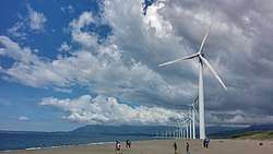 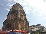 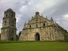 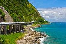   From top, left to right: Bangui Wind Farm, Sinking bell tower of Laoag, St. Augustine Church in Paoay, Patapat Viaduct in Pagudpud, Cape Bojeador Lighthouse in Burgos and La Paz Sand Dunes | |
 Flag  Seal | |
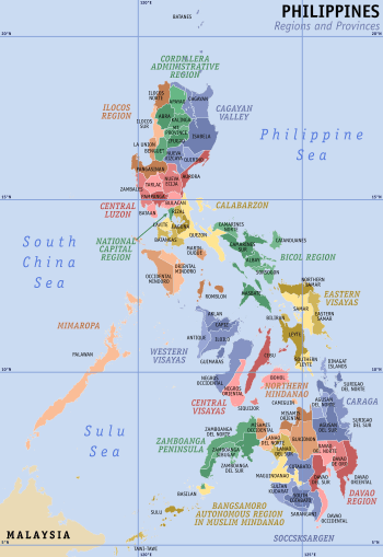
 Location in the Philippines | |
| Coordinates: 18°10′N 120°45′E | |
| Country | Philippines |
| Region | Ilocos Region (Region I) |
| Founded | 1818 |
| Capital | Laoag |
| Government | |
| • Type | Sangguniang Panlalawigan |
| • Governor | Matthew Marcos Manotoc (NP) |
| • Vice Governor | Cecilia Araneta-Marcos (NP) |
| Area | |
| • Total | 3,467.89 km2 (1,338.96 sq mi) |
| Area rank | 38th out of 81 |
| Highest elevation | 2,354 m (7,723 ft) |
| Population (2015 census)[2] | |
| • Total | 593,081 |
| • Rank | 48th out of 81 |
| • Density | 170/km2 (440/sq mi) |
| • Density rank | 52nd out of 81 |
| Divisions | |
| • Independent cities | 0 |
| • Component cities | |
| • Municipalities | |
| • Barangays | 557 |
| • Districts | 1st and 2nd districts of Ilocos Norte |
| Time zone | UTC+8 (PHT) |
| ZIP code | 2900–2922 |
| IDD : area code | +63 (0)77 |
| ISO 3166 code | PH |
| Spoken languages | |
| Website | www |
Ilocos Norte is noted for being the birthplace of the former President Ferdinand E. Marcos.
History
Long before the arrival of the Spaniards, there already existed an extensive region (consisting of the present provinces of Ilocos Norte, Ilocos Sur, Abra and La Union) renowned for its gold mines. Merchants from Japan and China would often visit the area to trade gold with beads, ceramics and silk. The Austronesian inhabitants of the region called their place samtoy, from sao mi toy, which literally meant "our language here"
In 1571, when the Spanish conquistadors had Manila more or less under their control, they began looking for new sites to conquer. Miguel Lopez de Legazpi's grandson, Juan de Salcedo, volunteered to lead one of these expeditions. Together with 8 armed boats and 45 men, the 22-year-old voyager headed north. On June 13, 1572, Salcedo and his men landed in present-day Vigan and then proceeded towards Laoag, Currimao and Badoc. As they sailed along the coast, they were surprised to see numerous sheltered coves (looc) where the locals lived in harmony. As a result, they named the region Ylocos and its people Ylocanos.
As the Christianization of the region grew, so did the landscape of the area. Vast tracts of land were utilized for churches and bell towers in line with the Spanish mission of bajo las campanas. In the town plaza, it was not uncommon to see garrisons under the church bells. The colonization process was slowly being carried out.
The Spanish colonization of the region, however, was never completely successful. Owing to the abusive practices of many Augustinian friars, a number of Ilocanos revolted. Noteworthy of these were the Dingras uprising (1589) and Pedro Almasan revolt (San Nicolas, 1660). In 1762, Diego Silang led a series of battles aimed at freeing the Ilocano. When he died from his compatriot's bullet, his widow Gabriela continued his cause. However, she too was captured and hanged.
In 1807, the sugar cane (basi) brewers of Piddig rose up in arms to protest the government's monopoly of the wine industry. In 1898, the church excommunicated Gregorio Aglipay for refusing to cut off ties with the revolutionary forces of Gen. Emilio Aguinaldo. Unperturbed, he established the Iglesia Filipina Independiente. Aglipay’s movement.
In an effort to gain more political control and because of the increasing population of the region, a Royal Decree was signed on February 2, 1818 splitting Ilocos into two provinces: Ilocos Norte and Ilocos Sur. Soon thereafter, La Union and Abra likewise became independent provinces.
Geography
Ilocos Norte covers a total area of 3,467.89 square kilometres (1,338.96 sq mi)[3] occupying the northern tip of the Ilocos Region in Luzon. The province is bordered by Cagayan to the extreme northeast, Apayao to the east, and Abra to the southeast, Ilocos Sur to the southwest, the South China Sea to the west, and the Luzon Strait to the north.
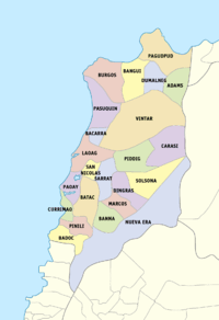
Administrative divisions
Ilocos Norte comprises 21 municipalities and 2 component cities, further subdivided into 559 barangays. There are two legislative districts in the province.
| ||||||||||||||||||||||||||||||||||||||||||||||||||||||||||||||||||||||||||||||||||||||||||||||||||||||||||||||||||||||||||||||||||||||||||||||||||||||||||||||||||||||||||||||||||||||||||||||||||||||||||||||||||||||||||||||||||||||||||||||||||||||||||||||||||||||||||||||||||||||||||||||||||||||||||||||||||||||||||||||||||||||||||||||||||||||||
Barangays
Ilocos Norte has 557 barangays comprising its 21 municipalities and 2 cities.[4]
The most populous barangay in the province is Barangay No. 1, San Lorenzo (Poblacion) in the City of Laoag with a population of 4,391 in the 2010 census. If cities are excluded, Davila in the municipality of Pasuquin has the highest population, at 3,900. The least populous is Sapat in the municipality of Pasuquin, with only 32.[4]
Demographics
| Population census of Ilocos Norte | |||||||||||||||||||||||||||||||||||||||||||||||||
|---|---|---|---|---|---|---|---|---|---|---|---|---|---|---|---|---|---|---|---|---|---|---|---|---|---|---|---|---|---|---|---|---|---|---|---|---|---|---|---|---|---|---|---|---|---|---|---|---|---|
|
| ||||||||||||||||||||||||||||||||||||||||||||||||
| Source: Philippine Statistics Authority[2][4][5] | |||||||||||||||||||||||||||||||||||||||||||||||||
The population of Ilocos Norte in the 2015 census was 593,081 people,[2] with a density of 170 inhabitants per square kilometre or 440 inhabitants per square mile.
Religion

Roman Catholicism and the Aglipayan Church are the two major religions in the province.
Among the major Roman Catholic churches in Ilocos Norte include:
- Paoay Church — named a UNESCO World Heritage Site in 1993.
- St. William's Cathedral in Laoag — known for its Sinking Bell Tower
- Santa Monica Church in Sarrat — documented to be the biggest church in the Ilocos Region.
- Bacarra Church — destroyed during an intensity VII (on the Rossi-Forel scale) earthquake on August 17, 1983,[6] reconstructed and re-inaugurated in 1984.
Ilocos Norte is the home of the Aglipay Shrine (Aglipayan Church) where the church's first supreme leader was buried. There are also increasing members of Jehovah's Witnesses. There are also minor but steadily increasing members of Iglesia ni Cristo. Islam is also practiced by Mindanaoan traders and immigrants.
Languages
Aside from the national language and English, there are three indigenous languages in Ilocos Norte. There are the dominant Ilokano language, the Isnag language of the east, and the Faire Atta language in Currimao.
The Faire Atta language is listed as one of the 15 endangered languages of the Philippines according to the UNESCO Atlas of the World's Endangered Languages. The Faire Atta language is listed as Severely Endangered, with less than 300 speakers remaining. All remaining speakers of the language are part of the community's elders. Without a municipality-wide teaching mechanism of the Faire Atta language for the youth, the language may be extinct within 3-5 decades, making it a language in grave peril unless a teaching-mechanism is established by either the government or an educational institution in Currimao and nearby municipalities.[7]
Economy

The province specializes in the following products and industries:
- Agriculture — rice, corn, garlic, legumes, root crops, tobacco, and other fruits and vegetables
- Fishery — tilapia and assorted fishes
- Livestock — swine and cattle
- Cottage industries — loom weaving, furniture, ceramics, iron works
- Manufacturing and food processing — salt, empanada, bagoong, patis, basi (native Ilocano wine), vinegar, longganisa, chicharon, bagnet, chichacorn (cornick), jewelry, garments, cereal processing, packaging, mechanized processing equipment
- Wind Power — Ilocos Norte's position on the northwest corner of Luzon makes it ideal for wind power generation. There is currently a 25 Megawatt wind farm in Ilocos Norte, and several more wind energy projects are being planned
- Tourism
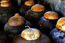
- Pottery
Government
Term of Office: June 30, 2019 - June 30, 2022
| Governor | Matthew Joseph Marcos-Manotoc |
|---|---|
| Vice Governor | Cecilia Araneta-Marcos |
| Representatives |
|
| Provincial Board Members | 1st District:
2nd District:
|
| PCL President | Handy T. Lao |
| ABC President | Elmer C. Faylogna |
| SK Federated President | Rafael Salvador C. Medina |
Tourism
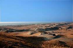
Ilocos Norte is also known as a northern tourist destination, being the location of Fort Ilocandia, hotel, resort and casino. Built between 1981 and 1983 by the Philippine Tourism Authority, the Spanish-Moroccan Villa was designed by Architect Jeorge Ramos. The golf course on Paoay Lake was built by Marcos in 1977, and designed by Gary Player.[8] Also of note are the La Paz Sand Dunes, Malacañang of the North, Cape Bojeador Lighthouse, Bangui Wind Farm, Saud Beach in Pagudpud, and the Early Pliocene calcarenite Kapurpurawan Burgos Formation, which has been sculpted by wind and waves.[9]
References
- "List of Provinces". PSGC Interactive. Makati City, Philippines: National Statistical Coordination Board. Archived from the original on 21 January 2013. Retrieved 26 September 2013.
- Census of Population (2015). "Region I (Ilocos Region)". Total Population by Province, City, Municipality and Barangay. PSA. Retrieved 20 June 2016.
- "Province: Ilocos Norte". PSGC Interactive. Quezon City, Philippines: Philippine Statistics Authority. Retrieved 8 January 2016.
- Census of Population and Housing (2010). "Region I (Ilocos Region)". Total Population by Province, City, Municipality and Barangay. NSO. Retrieved 29 June 2016.
- "Philippines Census Of Population of all LGUs 1903-2007". Archive.org. Philippine Statistics Authority. Retrieved 7 February 2017.
- "Laoag Earthquake - 17 August 1983". Phivolcs. 1983. Archived from the original on 15 August 2011. Retrieved 2011-01-02.
- "UNESCO Atlas of the World's Languages in danger". Unesco.org. Retrieved 23 February 2019.
- "Fort Ilocandia". discover philippines (September–October): 16–17, 24. 2004.
- Callejo, Gretchen; De Silva, Leopoldo; Fernando, Allan (2017). "New age assignment of the Kapurpurawan Rock Formation Calcarenite in Burgos Ilocos Norte Based on Planktonic Foraminiferal Assemblage". Journal of the Geological Society of the Philippines: 26–40.
External links


- Ilocos Norte Official Website
Places adjacent to Ilocos Norte | ||||||||||
|---|---|---|---|---|---|---|---|---|---|---|
| ||||||||||
Laoag (capital) | |
| Municipalities | |
| Component cities | |
| Barangays | |

| Authority control |
|
|---|