Cotabato
Cotabato, formerly but still colloquially known as North Cotabato (Hiligaynon: Aminhan Cotabato; Cebuano: Amihanang Cotabato; Maguindanaon: Pangutaran Kutawatu, Ilocano: Amianan nga Cotabato), is a landlocked province in the Philippines. While the province itself is geographically located in the Mindanao region of Soccsksargen, some of its barangays are under the jurisdiction of the nearby Bangsamoro Autonomous Region.
Cotabato | |
|---|---|
| Province of Cotabato | |
 Flag  Seal | |
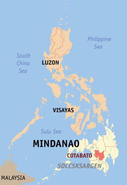 Location in the Philippines | |
| Coordinates: 7°12′N 124°51′E | |
| Country | Philippines |
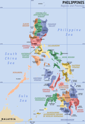
| Region | Soccsksargen (Region XII) |
| Foundation |
|
| Capital | Kidapawan |
| Government | |
| • Governor | Nancy A. Catamco (PDP-Laban) |
| • Vice Governor | Emmylou Taliño-Mendoza (Nacionalista Party) |
| Area | |
| • Total | 9,008.90 km2 (3,478.36 sq mi) |
| Area rank | 6th out of 81 |
| Highest elevation | 2,954 m (9,692 ft) |
| Population (2015 census)[2] | |
| • Total | 1,379,747 |
| • Rank | 17th out of 81 |
| • Density | 150/km2 (400/sq mi) |
| • Density rank | 57th out of 81 |
| Divisions | |
| • Independent cities | 0 |
| • Component cities | |
| • Municipalities | 17
|
| • Barangays | 543 |
| • Districts | 1st to 3rd districts of Cotabato |
| Time zone | UTC+8 (PST) |
| ZIP code | 9400–9417 |
| IDD : area code | +63 (0)64 |
| ISO 3166 code | PH |
| Spoken languages | |
| Income classification | 1st class |
| Website | cotabatoprov |
History
Early history
Cotabato derives its name from the Maguindanao word kuta wato (from Malay - "Kota Batu"), meaning "stone fort", referring to the stone fort which served as the seat of Sultan Muhammad Kudarat in what is now Cotabato City (which the province derives its name from).
Islam was introduced in this part of the country in the later part of the 15th century by Sharif Mohammed Kabungsuwan, an Arabo-Malay Muslim warrior-missionary. Sharif Kabungsuwan invaded Malabang in 1475, facing armed resistance from the non-Muslim natives, nevertheless successfully vanquishing and subjugating them to his (Islamic) rule through the might of his Samal warriors.[3]
Modern historians have pointed to the Cotabato delta as the medieval location of Toupo, the successor of the Maguindanao/Cotabato Sultanate.[4]
Spanish occupation
Christianity was introduced in 1596, but the Spaniards were unable to penetrate into the region until the second half of the 19th century. The district of Cotabato was formed in 1860,[5] covering the areas of what is now Cotabato, Maguindanao and Sultan Kudarat provinces with its capital at Tamontaka. Fort Pikit was established by the Spaniards in 1893 as they continued their conquest of the remnants of Maguindanao Sultanate, which would soon be the site of one of the province's oldest towns, Pikit.
American occupation
The coming of the Americans ushered in the creation of the Moro Province on July 15, 1903, through Act No. 787 of the Philippine Commission. Cotabato, covering what are now the provinces of Cotabato, Maguindanao, Sultan Kudarat, South Cotabato and Sarangani, became a district of the huge Moro province. During the American period, large companies were established in Cotabato to exploit the vast timber resources of the region. By the 1930s, settlers from Luzon and Visayas established homesteads in Cotabato.
World War II
In December 1941, Japanese planes bombed and invaded Cotabato. In 1942, Cotabato was occupied by the Japanese Imperial forces. A military headquarters of the Philippine Commonwealth Army existed in Cotabato from January 3, 1942 to June 30, 1946 and the Philippine Constabulary 10th Constabulary Regiment was stationed in Cotobato from October 28, 1944 to June 30, 1946. Moro guerrilla fighters operating in the province of Cotabato helped local forces of the Philippine Commonwealth Army and the Philippine Constabulary 10th Constabulary Regiment fight against the Imperial Japanese Army until 1944. The Moro guerrillas fought the Japanese troops until liberation. In 1945, Cotabato was recaptured from the Japanese Imperial forces by the combined Filipino and American troops together with the recognized Moro guerrilla units. The guerrillas used the traditional Moro Kampilan, Barong and Kris swords as their weapons.
Sovereign Philippines
The pace of settlement in the region accelerated in the 1950s and 1960s. The former province of Cotabato was once the largest in the Philippines. In 1966, South Cotabato was created as a separate province.[6] In 1992, the province of Sarangani was formed out of South Cotabato.[7] On November 22, 1973, through Presidential Decree No. 341, what remained of the old Cotabato was further divided into the provinces of North Cotabato, Maguindanao, and Sultan Kudarat.[8] North Cotabato was later renamed Cotabato through Batas Pambansa Blg. 660 approved on March 7, 1984.[9]
Cotabato now comprises the capital city of Kidapawan and 17 municipalities.
By the aftermath of the plebiscite to form the autonomous administrative region of Bangsamoro in February 2019, 63 barangays from Cotabato's western municipalities, all of which inhabited mostly by Muslim natives, opted to join the newly-formed region.[10] This will result in the reduction of the number of barangays the province currently administers after the national midterm elections on 13 May 2019.[11]
Geography
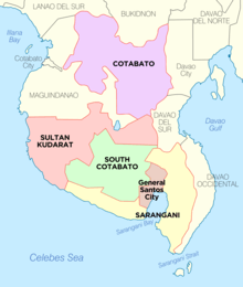
Cotabato covers a total area of 9,008.90 square kilometres (3,478.36 sq mi)[12] occupying the northeastern tip of Region XII and is centrally located in Mindanao. It is bounded on the north by the provinces of Lanao del Sur and Bukidnon, on the east by Davao City and Davao del Norte, on the west by Maguindanao and on the southeast by Sultan Kudarat and Davao del Sur.
Cotabato is strategically linked to the major "Arterial Road System" that traverses and connects the province to Davao City - Soccsksargen - Cotabato Corridor. The Cotabato via Kabacan - Maramag - Kibawe, Bukidnon Sayre Highway meanwhile serves as its link to the Cagayan de Oro-Iligan City Corridor.
Cotabato stretches from the east at Mount Apo, which separates it from Davao, to the Piapayungan Range on its boundary with Lanao in the west.[13] Between these highlands is the basin of the Pulangi River or Rio Grande de Mindanao,[13] the second longest in the Philippines at 373 kilometres (232 mi), which rises in Bukidnon and flows south to Maguindanao and Illana Bay. The province's fertile plains are traversed by tributaries of this great river.
Typhoons do not pass through Cotabato and rainfall is evenly distributed throughout the year.[13]
| Climate data for Cotabato | |||||||||||||
|---|---|---|---|---|---|---|---|---|---|---|---|---|---|
| Month | Jan | Feb | Mar | Apr | May | Jun | Jul | Aug | Sep | Oct | Nov | Dec | Year |
| Average high °C (°F) | 30.5 (86.9) |
31.0 (87.8) |
32.0 (89.6) |
32.8 (91.0) |
32.2 (90.0) |
31.8 (89.2) |
31.3 (88.3) |
31.5 (88.7) |
31.8 (89.2) |
32.3 (90.1) |
31.8 (89.2) |
31.3 (88.3) |
31.7 (89.0) |
| Average low °C (°F) | 23.7 (74.7) |
23.9 (75.0) |
24.1 (75.4) |
24.7 (76.5) |
24.8 (76.6) |
24.6 (76.3) |
24.4 (75.9) |
24.5 (76.1) |
24.4 (75.9) |
24.4 (75.9) |
24.4 (75.9) |
24.2 (75.6) |
24.3 (75.8) |
| Average rainy days | 15 | 11 | 13 | 11 | 15 | 17 | 15 | 14 | 13 | 15 | 15 | 13 | 167 |
| Source: Storm247 [14] | |||||||||||||
Administrative divisions
Cotabato comprises 17 municipalities and one city.[12]

- † Provincial capital and component city
- Municipality
| |||||||||||||||||||||||||||||||||||||||||||||||||||||||||||||||||||||||||||||||||||||||||||||||||||||||||||||||||||||||||||||||||||||||||||||||||||||||||||||||||||||||||||||||||||||||||||||||||||||||||||||||||||||||||||||||||||||||||||||||||||||||||||||||||||||||||||||||||||||||
Future reduction due to the establishment of the Bangsamoro
During the 2001 Referendum for inclusion to the Autonomous Region in Muslin Mindanao, 2 out of 28 barangays of Carmen, Cotabato chose to be part of ARMM, but were excluded because they are not connected to the main region of ARMM. During 2010-2016 Administration, the Bangsamoro ideal sprouted and a newly proposed region was in the making. According to the agreements signed by the Moro Islamic Liberation Front and the Administration of Noynoy Aquino, Carmen will be included in Bangsamoro because of the two out of twenty-eight barangays that voted in favor of joining the Muslim region back in 2001. Unfortunately, Bangsamoro was not implemented before the term of Aquino ended. Despite this, the current administration aims to establish a Federal Government, where Bangamoro will be realized into a State of the Philippines wherein Carmen will be included in Bangsamoro.
Plans to establish a new municipality in the south of Carmen so that the indigenous and Christian central and northern part of Carmen will be retained in North Cotabato has yet to be confirmed. The idea arose because once the entire municipality of Carmen is included in Bangsamoro, the province of North Cotabato will be cut into half, leaving three towns (Banisilan, Alamada, and Libungan) at its west without connection to the center of North Cotabato, isolating these towns in the process.
The issue was partially resolved when the second part of the plebiscite was conducted on 6 February 2019, when 63 barangay from the towns of Pigkawayan, Libungan, Midsayap, Aleosan, Carmen, Banisilan and Pikit opted to join the new administrative autonomous region of Bangsamoro after the results of the region's formation plebiscite were confirmed three days later on 9 February.[10] However, these barangays are only to join the adjacent province of Maguindanao as parts of the said province's nearby and respective municipalities or to cluster on their own as new municipalities within the said province after the national midterm elections on 13 May 2019, and only then would the size and population of Cotabato province would truly diminish as the leaving barangays would no longer officially be parts of the province.[11]
Demographics
| Population census of Cotabato | ||
|---|---|---|
| Year | Pop. | ±% p.a. |
| 1990 | 763,995 | — |
| 1995 | 862,666 | +2.30% |
| 2000 | 958,643 | +2.29% |
| 2007 | 1,121,974 | +2.19% |
| 2010 | 1,226,508 | +3.29% |
| 2015 | 1,379,747 | +2.27% |
| Source: Philippine Statistics Authority[2][15][15] | ||
Based on the 2015 census, Cotabato has an overall population of 1,379,747.[2] The average population growth rate was 2.27% in the period 2010–2015, which is higher than the national average of 1.72%. The province had a density of 150 inhabitants per square kilometre or 390 inhabitants per square mile.
Cotabato is an ethnoliguistically diverse province. The first Visayan settlers reached the town of Pikit in 1913, and since then, Christian migrants have moved and lived in Cotabato, cohabitating the province with the local indigenous groups. 71% of Cotabato's population descended from settlers who migrated from the Visayas and Luzon, while the remaining 18% belong to the communities of Magindanaons, Iranuns, Ilianens, Dulangan Manobo, Obo, Tagabawa, and Tboli. The major languages spoken are Hiligaynon (46%), Maguindanao (38%), Cebuano (8%), and Ilocano (4%).[13]
Religion
Cotabato's population is majority Christian. According to the 2010 census,[16] 51.2% of the population are Roman Catholic.[17] Muslims form 26% of the population.[18] The other significant minorities are Evangelical Christians at 8.4% of the population and Iglesia Ni Cristo which forms 1.9% of the Province population.[19] In 2015 the Philippine Statistics Authority recorded Islam followed by 39.28% of the population.[20]
Economy
Cotabato is considered a major food basket in Mindanao. It is a top producer of cereals, tropical fruits, vegetables, sugarcane, coconut, coffee, freshwater fish and livestock.
It is also one of the country's leading producers of raw and semi-processed rubber and industrial trees,[21] with markets in Asia and Europe.
Among its major natural assets are Mt. Apo, the country's highest peak at 9,692 feet (2,954 m) above sea level, the Pulangi River which is a major contributor to Mindanao's irrigation system and hydro-electric energy, and the vast Liguasan Marsh which not only supplies a bounty of freshwater fish and organic fertilizer but considered as a possible source as well of natural gas.
Power utility in the province comes from two energy sources - the NAPOCOR Agus Grid in Iligan transmitted through its Tacurong Substations and the Mindanao 1 Geothermal Power Plant at the foot of Mt. Apo in Ilomavis, Kidapawan City which produces 97 megawatts of electricity. Power distribution is handled by Cotabato Electric Cooperative, Inc. (COTELCO).
The province has a 4,131.32-kilometre (2,567.08 mi) road network connecting the major centers to each other and the outlying barangays, and communication linkage through NDD-IDD, fax, cellular phone and the internet is available.
Government
President Benigno Aquino III signed the law dividing to new 3 legislative district of Cotabato on September 14, 2012. The representative shall continue to serve until next national election.[22]
Elected provincial officials
- House of Representatives
- 1st District — Rep. Joel Sacdalan
- 2nd District — Rep. Rudy Caodagan
- 3rd District — Rep. Jose Pingping I. Tejada
- Governor: Nancy Catamco
- Vice Governor: Lala T.Mendoza
References
- "List of Provinces". PSGC Interactive. Makati City, Philippines: National Statistical Coordination Board. Archived from the original on January 21, 2013. Retrieved June 3, 2014.
- Census of Population (2015). "Region XII (Soccsksargen)". Total Population by Province, City, Municipality and Barangay. PSA. Retrieved 20 June 2016.
- Halili, Christine N. (2004). "The Natural Setting and its People". Philippine History (First ed.). Manila, Philippines: Rex Book Store. pp. 52–53. ISBN 9712339343. Retrieved 29 April 2016.
- "ASIAPACIFICUNIVERSE.COM". www.booked.net.
- "Our Province". Province of Cotabato (government website). Retrieved 29 April 2016.
- "Republic Act No. 4849 - An Act Creating the Province of South Cotabato". Chan Robles Virtual Law Library. 18 July 1966. Retrieved 27 April 2016.
- "Republic Act No. 7228 - An Act Creating the Province of Sarangani". Chan Robles Virtual Law Library. 16 March 1992. Retrieved 27 April 2016.
- "Presidential Decree No. 341: Creating the Provinces of North Cotabato, Maguindanao and Sultan Kudarat". Philippine Laws, Statutes & Codes. Chan Robles Virtual Law Library. 22 November 1973. Retrieved 27 May 2014.
- "Batas Pambansa Blg. 660 - An Act Changing the Name of the Province of North Cotabato to Cotabato". Philippine Laws, Statutes & Codes. Chan Robles Virtual Law Library. 22 November 1973. Retrieved 27 May 2014.
- CNN Philippines Staff. "63 North Cotabato villages complete new Bangsamoro region". CNN Philippines. Retrieved 14 February 2019.
- Carolyn O. Arguillas. "Pikit's fate: 20 barangays remain with North Cotabato, 22 joining BARMM". MindaNews. Retrieved 8 February 2019.
- "Province: Cotabato". PSGC Interactive. Quezon City, Philippines: Philippine Statistics Authority. Retrieved 8 January 2016.
- Lancion, Jr., Conrado M.; cartography by de Guzman, Rey (1995). "The Provinces; Cotabato". Fast Facts about Philippine Provinces (The 2000 Millenium ed.). Makati, Metro Manila, Philippines: Tahanan Books. p. 64. ISBN 971-630-037-9. Retrieved 29 April 2016.
- "Weather forecast for North Cotabato, Philippines". Storm247.com. StormGeo AS, Nordre Nøstekaien 1, N-5011 Bergen, Norway: StormGeo AS. Retrieved 29 April 2016.CS1 maint: location (link)
- Census of Population and Housing (2010). "Region XII (Soccsksargen)". Total Population by Province, City, Municipality and Barangay. NSO. Retrieved 29 June 2016.
- https://psa.gov.ph/sites/default/files/NORTH%20COTABATO_FINAL%20PDF.pdf
- Bueza, Michael. "MAP: Catholicism in the Philippines". Rappler.
- Bueza, Michael. "MAP: Islam in the Philippines". Rappler.
- Bueza, Michael. "MAP: Iglesia ni Cristo in the Philippines". Rappler.
- Philippine Statistics Authority (July 26, 2017). "Muslim Population in Mindanao (based on POPCEN 2015". Retrieved Aug 31, 2018.
- Cabrera, Ferdinandh B. (22 August 2013). "NorthCot pushes rubber industry dev't". MindaNews. Mindanao News and Information Cooperative Center (MNICC). Retrieved 29 April 2016.
North Cotabato is the country’s second largest rubber producer, next to Zamboanga Sibugay, with a rubber plantation area of at least 55,000 hectares.
- Burgonio, TJ (15 September 2012). "Aquino signs law reapportioning Cotabato into 3 districts". Philippine Daily Inquirer. Retrieved 16 December 2015.
External links


- Province of Cotabato
- Philippine Standard Geographic Code
Places adjacent to Cotabato | |
|---|---|
Kidapawan (capital) | |
| Municipalities | |
| Component city | |
| Related | |