Zamboanga del Norte
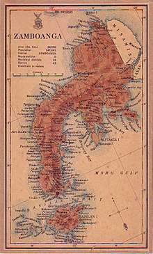
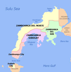
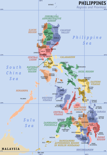
Zamboanga del Norte (Cebuano: Amihanang Zamboanga; Subanon: Utara Sembwangan) is a province in the Philippines situated within the Zamboanga Peninsula region in Mindanao. Its capital is Dipolog City and the province borders Zamboanga del Sur and Zamboanga Sibugay to the south, Misamis Occidental to the east, and the Sulu Sea to the west.
Zamboanga del Norte | |
|---|---|
| Province of Zamboanga del Norte[1] | |
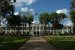 The Zamboanga del Norte Provincial Capitol in Dipolog City prior to its renovation in 2012. | |
 Flag  Seal | |
| Motto(s): Unity, Prosperity, Peace | |
 Location in the Philippines | |
| Coordinates: 8°08′00″N 123°00′00″E | |
| Country | Philippines |
| Region | Zamboanga Peninsula (Region IX) |
| Founded | June 23, 1635 and June 6, 1952 |
| Capital | Dipolog |
| Government | |
| • Type | Sangguniang Panlalawigan |
| • Governor | Roberto Y. Uy (PDP-Laban) |
| • Vice Governor | Senen O. Angeles (PDP-Laban) |
| Area | |
| • Total | 7,301.00 km2 (2,818.93 sq mi) |
| Area rank | 9th out of 81 |
| Highest elevation (Mount Dabiak) | 2,600 m (8,500 ft) |
| Population (2015 census)[3] | |
| • Total | 1,011,393 |
| • Rank | 26th out of 81 |
| • Density | 140/km2 (360/sq mi) |
| • Density rank | 60th out of 81 |
| Divisions | |
| • Independent cities | 0 |
| • Component cities | |
| • Municipalities | 25
|
| • Barangays | 691 |
| • Districts | 3 districts of Zamboanga del Norte |
| Time zone | UTC+8 (PHT) |
| ZIP code | 7100–7124 |
| IDD : area code | +63 (0)65 |
| ISO 3166 code | PH |
| Spoken languages | |
| Income classification | 1st class |
| Website | www |
Zamboanga del Norte is the largest province of the Zamboanga Peninsula region by land area covering 7,301.00 square kilometres (2,818.93 sq mi).[2] Zamboanga del Norte is the 26th populous province in the Philippines.
History
Prior to its creation as a province, Zamboanga del Norte formed the northern portion of the historical province of Zamboanga.
The early history of Zamboanga del Norte is shared with that of Zamboanga City, which had been the center of the entire Mindanao area, most notably during the American era. When Zamboanga City became a chartered city on October 12, 1936, it encompassed the southern tip of the Zamboanga Peninsula and the island of Basilan, making it the largest city in the world in terms of land area.
Through Republic Act No. 711 issued on June 6, 1952, Zamboanga province was divided into two independent provinces, which included Zamboanga del Sur.[4]
In 2017, House Bill No. 5040 was introduced in the House of Representatives seeking to carve out a new province from Zamboanga del Norte. The proposed Zamboanga Hermosa province was to consist of 12 municipalities and 2 legislative districts that make up the 3rd legislative district of Zamboanga del Norte:[5][6] Baliguian, Godod, Gutalac, Kalawit, Labason, Leon B. Postigo, Liloy (its proposed capital), Salug, Sibuco, Siocon, Sirawai, and Tampilisan. However, the bill ultimately did not pass the 16th congress.
Geography
Zamboanga del Norte covers a total area of 7,301.00 square kilometres (2,818.93 sq mi)[7] occupying the northern portion of the Zamboanga Peninsula in western Mindanao. The province is bordered on the north and west by the Sulu Sea, on the northeast by Misamis Occidental, and on the south by Zamboanga del Sur and Zamboanga Sibugay.
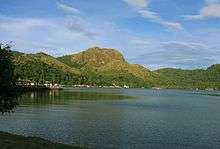
It has an average elevation of 243.8 metres (800 ft), with Mount Dabiak in Katipunan as the highest peak at 2,600 metres (8,500 ft). Other parts, near the coastlines, are plains. The province's irregular coastline runs some 400 kilometres (250 mi) from north to south.
Climate
Zamboanga del Norte has a mild and moderate climate due to evenly distributed rainfall throughout the year. Its southern portion has a longer dry season.
| Climate data for Zamboanga del Norte | |||||||||||||
|---|---|---|---|---|---|---|---|---|---|---|---|---|---|
| Month | Jan | Feb | Mar | Apr | May | Jun | Jul | Aug | Sep | Oct | Nov | Dec | Year |
| Average high °C (°F) | 30.4 (86.7) |
30.5 (86.9) |
31.6 (88.9) |
32.6 (90.7) |
32.3 (90.1) |
31.7 (89.1) |
31.6 (88.9) |
31.6 (88.9) |
31.8 (89.2) |
31.5 (88.7) |
31.4 (88.5) |
30.8 (87.4) |
31.5 (88.7) |
| Average low °C (°F) | 21.8 (71.2) |
21.9 (71.4) |
20.8 (69.4) |
22.2 (72.0) |
21.2 (70.2) |
21.0 (69.8) |
21.1 (70.0) |
21.0 (69.8) |
21.1 (70.0) |
21.3 (70.3) |
21.4 (70.5) |
21.3 (70.3) |
21.3 (70.4) |
| Average rainy days | 15 | 10 | 8 | 7 | 10 | 17 | 16 | 16 | 14 | 16 | 17 | 16 | 162 |
| Source: Storm247[8] | |||||||||||||
Administrative divisions

Zamboanga del Norte comprises 25 municipalities and 2 cities. Dipolog City, Sindangan and Dapitan City are the top most densely populated area in the province These are further subdivided into 691 barangays, and clustered into 3 congressional districts.[7]
Sibuco is the largest municipality by land area, constituting 10.72% (782.54 square kilometers) of the total provincial area. Sibutad is the smallest, with 0.90% (65.57 square kilometers).[7]
- † Provincial capital and component city
- ∗ Component city
- Municipality
| ||||||||||||||||||||||||||||||||||||||||||||||||||||||||||||||||||||||||||||||||||||||||||||||||||||||||||||||||||||||||||||||||||||||||||||||||||||||||||||||||||||||||||||||||||||||||||||||||||||||||||||||||||||||||||||||||||||||||||||||||||||||||||||||||||||||||||||||||||||||||||||||||||||||||||||||||||||||||||||||||||||||||||||||||||||||||||||||||||||||||||||||||||||||||||||||||||||||||||||
Demographics
| Population census of Zamboanga del Norte | ||
|---|---|---|
| Year | Pop. | ±% p.a. |
| 1939 | 138,849 | — |
| 1948 | 167,700 | +2.12% |
| 1960 | 281,429 | +4.41% |
| 1970 | 409,379 | +3.81% |
| 1975 | 490,515 | +3.69% |
| 1980 | 588,015 | +3.69% |
| 1990 | 676,021 | +1.40% |
| 1995 | 770,697 | +2.49% |
| 2000 | 823,130 | +1.42% |
| 2007 | 907,238 | +1.35% |
| 2010 | 957,997 | +2.00% |
| 2015 | 1,011,393 | +1.04% |
| Source: Philippine Statistics Authority[3][9][10] | ||
The population of Zamboanga del Norte in the 2015 census was 1,011,393 people,[3] with a density of 140 inhabitants per square kilometre or 360 inhabitants per square mile. Dipolog is the most populated area in the land, followed by a first class town- Sindangan, then Dapitan.
The main language spoken is Cebuano. Other languages include Chavacano, Subanen, Tausug, and English.
Religion
The predominant religion was Islam until the Spanish regime reign over the region and spread Christianity by the help of the church's missionary congregations like the Jesuits, Augustinians, and Dominicans. The province hailed its first martyr of faith soon to be raised as a saint in the whole Mindanao island by the name of Padre Francesco Palliola, S.J. He was a jesuit missionary from Nola, Italy and was assigned to Zamboanga Peninsula. He held missionary works in Lubungan (Katipuan), Zamboanga del Norte, Iligan, Dapitan, and met his martyrdom at the barrio of Ponot now a town of Jose Dalman. Roman Catholicism is a significant majority with about 50% adherence. The province have one diocese – the Roman Catholic Diocese of Dipolog under the Archdiocese of Ozamiz, covering the entire province. There are also followers of other Christian sects.
Government
Officials
Members of the House of Representatives:
- 1st District: Rep. Romeo "Jon-jon" M. Jalosjos, Jr.
- 2nd District: Rep. Glona G. Labadlabad
- 3rd District: Rep. Isagani "Gani" S. Amatong
Governor: Roberto "Berto" Y. Uy
Vice Governor: Senen O. Angeles
Board Members
|
|
|
Economy
About half of the province's land area is devoted to agriculture. Corn, coconut, and rice are the major crops. The province being rich in marine and mineral sources, its fish production has accelerated through the development of fishponds. Commercial fishing has steadily increased through the years, with the yellow fin tuna as the primary species.
In 2006, a study by National Statistics Coordination Board (NSCB), found Zamboanga del Norte Province to be the Philippines' poorest province with a poverty incidence rate of 64.6%, an increase from 47% in year 2000 statistical figures.[11]
As of 2015, the province's poverty incidence has dropped to 51.6% (ranking 8th).[12] Large foreign mining companies operating within the province such as Canadian company TVI Resource Development and Philex Mining Corp. cause adverse effects to the culture and traditions of the indigenous Subanon and other poor settlers.[13][14][15]
References
- (Subanon: Utara Sembwangan, Chavacano: Provincia de Zamboanga del Norte; Cebuano: Amihanang Zamboanga)
- "List of Provinces". PSGC Interactive. Makati City, Philippines: National Statistical Coordination Board. Archived from the original on May 18, 2001. Retrieved 8 August 2014.
- Census of Population (2015). "Region IX (Zamboanga Peninsula)". Total Population by Province, City, Municipality and Barangay. PSA. Retrieved 20 June 2016.
- "Republic Act No. 711 - An Act to Create The Provinces of Zamboanga del Norte and Zamboanga del Sur". Chan Robles Virtual Law Library. Retrieved 28 September 2013.
- Isagani S. Amatong (February 14, 2017). "House Bill No. 5040: An Act Creating the Province of Zamboanga Hermosa from the Province of Zamboanga Del Norte" (PDF). www.congress.gov.ph. Republic of the Philippines - House of Representatives. Retrieved 10 March 2017.
- "Seventeenth Congress First Regular Session 2016 - 2017" (PDF). Journal of the House of Representatives. Journal Service Plenary Affairs Bureau. No. 73. February 21, 2017. Retrieved 10 March 2017.
- "Province: Zamboanga del Norte". PSGC Interactive. Quezon City, Philippines: Philippine Statistics Authority. Retrieved 8 January 2016.
- "Weather forecast for Zamboanga del Norte, Philippines". Storm247.com. Bergen, Norway: StormGeo AS. Retrieved 19 April 2016.
- Census of Population and Housing (2010). "Region IX (Zamboanga Peninsula)". Total Population by Province, City, Municipality and Barangay. NSO. Retrieved 29 June 2016.
- "Philippines Census Of Population of all LGUs 1903-2007". archive.org. Philippine Statistics Authority. Retrieved 14 February 2017.
- "Ten poorest provinces in 2003". Press Release. Makati City, Philippines: National Statistical Coordination Board. 6 June 2006. Retrieved 27 October 2012.
- "Philippine Statistics Authority | Republic of the Philippines". openstat.psa.gov.ph. Retrieved 2018-01-09.
- Olchondra, Riza T. (1 November 2011). "Open pit mine ban to hit TVI projects, Philex plan in Zamboanga Norte". Philippine Daily Inquirer. Retrieved 19 April 2016.
Zamboanga del Norte has issued an ordinance banning open-pit mining in the province, threatening projects of mining firms operating in the area, such as those of TVI Resource Development.
- Fiel, Tito N. (12 November 2011). "Zamboanga del Norte ban on open-pit mining stands". Philippine Daily Inquirer. Inquirer Mindanao. Retrieved 19 April 2016.
The provincial government of Zamboanga del Norte stands fast on its ban on open-pit mining and will fight in court the Canadian-mining company TVI Resources’ efforts to have the ordinance declared unconstitutional.
- "TVI Pacific closes Zamboanga mine". ABS-CBN News. 21 January 2014. Retrieved 19 April 2016.
External links


- Old website of the Province of Zamboanga del Norte
- Daily Zamboanga Times
Places adjacent to Zamboanga del Norte | ||||||||||
|---|---|---|---|---|---|---|---|---|---|---|
| ||||||||||
Dipolog (capital) | |
| Municipalities | |
| Component cities | |

| Authority control |
|
|---|