Benguet
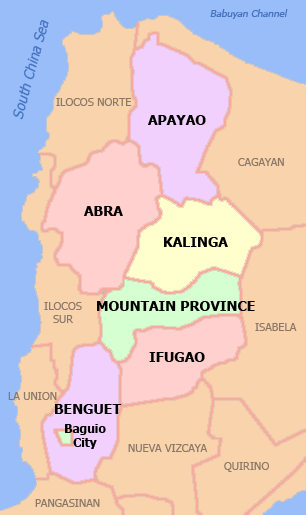
Benguet (Tagalog pronunciation: [beŋˈɡet]; Ibaloi: Probinsya ne Benguet; Ilocano: Probinsia ti Benguet; Pangasinan: Luyag na Benguet; Tagalog: Lalawigan ng Benguet) is a landlocked province of the Philippines located in the southern tip of the Cordillera Administrative Region in the island of Luzon. Its capital is La Trinidad.
Benguet | |
|---|---|
| Province of Benguet | |
 Flag  Seal | |
| Nickname(s): | |
 Location in the Philippines | |
| Coordinates: 17°N 121°E | |
| Country | Philippines |
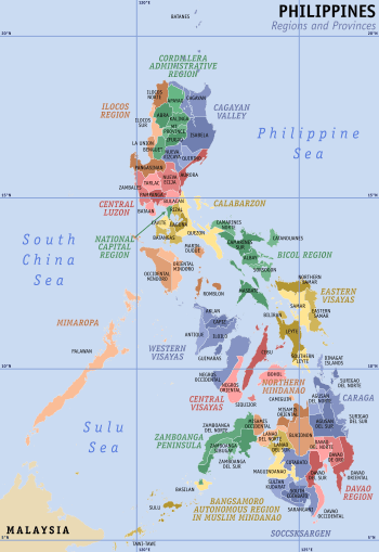
| Region | Cordillera Administrative Region (CAR) |
| Founded | November 23, 1900 |
| Province | June 16, 1966 |
| Capital | La Trinidad |
| Government | |
| • Type | Sangguniang Panlalawigan |
| • Governor | Melchor D. Diclas (PDP-LBN) |
| • Vice Governor | Johnny D. Waguis (PDP-LBN) |
| • Congressman | Nestor B. Fongwan (PDP-LBN) |
| Area | |
| • Total | 2,769.08 km2 (1,069.15 sq mi) |
| Area rank | 47th out of 81 |
| (excluding Baguio City) | |
| Highest elevation | 2,926 m (9,600 ft) |
| Population (2015 census)[4] | |
| • Total | 446,224 |
| • Rank | 61st out of 81 |
| • Density | 160/km2 (420/sq mi) |
| • Density rank | 55th out of 81 |
| (excluding Baguio City) | |
| Divisions | |
| • Independent cities | 1
|
| • Component cities | 0 |
| • Municipalities | |
| • Barangays |
|
| • Districts |
|
| Time zone | UTC+8 (PST) |
| ZIP code | 2600–2614 |
| IDD : area code | +63 (0)74 |
| ISO 3166 code | PH |
| Spoken languages | |
| Website | benguet |
The highland province is known as the Salad Bowl of the Philippines due to its huge production of upland vegetables.[1][2][5]
Situated within the interior of Benguet is the highly urbanized city of Baguio, which is administered independent from the province.
History
The mountainous area now covered by Benguet is generally presumed to have been settled from at least the 14th century by tribes coming from the surrounding lowlands, lured by the abundance of natural resources such as gold, hides, and wax. Two of these groups, the Ibaloi and the Kankanaey, are dominant ethnolinguistic groups of the area. In the pre-conquest period, these tribes enjoyed flourishing trade with lowland groups immediately to their west and south, such as the Pangasinans. Governor Juan "Oraa" Cariño (1913-1918) one of the governors of Benguet, was the first Filipino to be a governor.
The Kankanay occupied the northern highlands of the province, while the Ibaloy occupied the southern portion, while all Igorots practiced animism and ancestor worship. Rituals were proscribed by the priests, mambunong. The economy of the region was based on rice terraces, root crop swidden farming, livestock raising, hunting, foraging, plus the mining and trading of gold. These Igorot gold mines were located in Suyoc, Tabio, Acupan, and Antamok. Gold panning took place in placer deposits along the Agno River, the Bued River, the Suyoc River, and the Amburayan River. Gold was also mined from lode veins within andesite and diorite. Gold in Mankayan was associated with copper. Gold mining resulted in social stratification, with the upper class consisting of the mine owners, the baknang, followed by the gold workers, or abiteg, and then the bagaen, or slave class. These slaves were made up of war captives, and their children. Gold mines were inheritable kinship property, while original ownership was bestowed on those individuals discovering the gold location, and then developing the property.[6][7]:183
Spanish period
At the beginning of the Spanish Era, colonisers heard of the rich gold mines in the mountains and attempted to colonize the highlands, but failed. In 1572, Spanish conquistador Juan de Salcedo led a small expedition into the southern part of Benguet, but the natives forced it to retreat.[5] The first major expedition into the mountains occurred in 1620, when Spanish explorers went into the La Trinidad Valley, followed by a second expedition in 1623, and a third in 1624. This was the last attempt to occupy the Baguio gold mines by the Spanish until the Galvey expeditions (1829-1839).[6]:473–475
In the 1800s, Spanish colonizers made more serious attempts such as expeditions under Col. Guillermo Galvey[8]:280 and succeeded in establishing a presence in the La Trinidad Valley, named after Galvey's wife.[5]
This area later became a district of the new province of La Montañosa (or La Montaña)[9][10] in 1846. Eight years later, in 1854, Benguet became a separate comandancia politico-militar. Parts of the present province were established as component territories of other comandancias such as Lepanto and Amburayan.[5]
American period
When the Americans took control of the Philippines, they established local civil governments in many parts of the country. American civilian government was established in Benguet on November 23, 1900 through Act No. 48, with Canadian journalist H.P. Whitmarsh appointed as the province's first governor.[11]
| Township | Abolished? | Notes | Township | Abolished? | Notes | |
|---|---|---|---|---|---|---|
| Adaoay | Yes | Currently part of Kabayan | Itogon | No | ||
| Ambuklao | Yes | Currently part of Bokod | Kabayan | No | ||
| Ampusongan | Yes | Currently part of Bakun | Kapangan | No | ||
| Atok | No | Kibungan | No | |||
| Baguio | Yes | Converted into a chartered city in 1909* | La Trinidad | No | ||
| Balakbak | Yes | Currently part of Kapangan | Loo | Yes | Currently part of Buguias | |
| Bokod | No | Palina | Yes | Currently part of Kibungan | ||
| Buguias | No | Sablan | No | |||
| Daclan | Yes | Currently part of Bokod | Tublay | No | ||
| Galiano | Yes | |||||
Upon the American colonial government enacting Act No. 1876 on August 18, 1908 which created Mountain Province from areas of the old La Montañosa, Benguet (along with Amburayan, Apayao, Bontoc, Ifugao, Kalinga, and Lepanto) became sub-provinces of this new province.[5][14] A year later in 1909, the township of Baguio was abolished upon its conversion into a chartered city. In 1920, portions of the sub-provinces of Amburayan and Lepanto were incorporated into Benguet.[5]
Mining companies started operating in the province in the 1930s. This brought jobs, and many lowlanders migrated to Benguet, especially in towns surrounding the gold mines, such as Itogon, Mankayan and Tuba.[15]
World War II
During World War II, Igorot guerrillas and the combined Filipino and American forces fought Japanese soldiers during the final days of the war in 1945.
Modern history
On June 18, 1966, the huge Mountain Province was split into four provinces with the enactment of Republic Act No. 4695. The four provinces were Benguet, Mountain Province, Kalinga-Apayao and Ifugao.[5][16][17]
On June 22, 1973, as part of the Integrated Organization Plan of Marcos, Benguet was placed under the jurisdiction of the Ilocos Region as a form of gerrymandering.[18] During the Marcos dictatorship, thousands of Benguet natives were tortured and murdered through various means such as rape, forced stripping, electric shocks, beatings, and genital mutilations, among many others. Benguet religious leaders rose up against Marcos until the People Power Revolution of 1986 occurred, where Corazon Aquino became president and democracy was restored.[19][20][21] When the Cordillera Administrative Region was established by President Corazon Aquino thru Executive Order 220 on July 15, 1987, Benguet was made one of its provinces.[5][22][23]
Geology
The Baguio Mining District consists of Late Cretaceous ophiolite basement rocks. These are overlain by Eocene back arc tholeiitic Pugo Metavolcanics. These grade into the Dalupirip Schist, which is separated from the Early Oligocene-Early Miocene sedimentary Zigzag Formation by an unconformity. The Zigzag is composed of deep depositional environment interbedded green sandstones, red siltstones, oligomicitc conglomerates, and minor limestone units. The late Early Miocene-early Middle Miocene reefal Kennon Limestone overlays the Zigzag. The Late Oligocene-Early Miocene Agno Batholith intrudes the Pugo and Zigzag. The Middle-Late Miocene Klondyke Formation was deposited during Central Cordillera geologic uplift, consisting of coarse clastics, polymictic conglomerates, sandstones, and vitric (glassy) tuffs, with minor shales and siltstones. Gold mineralization occurred with dioritic and gabbroic intrusions, and basaltic to andesitic lavas, including the Monglo adakite. The Pliocene Baguio Formation consists of conglomerates interbedded with lava flows and pyroclastics. Pleistocene gold-copper mineralization occurred with calc-alkaline and dioritic and dacitic adakitic intrusions. This mineralization characterizes the Philex Mine.[24]
The main gold base metal mineralization zone is approximately 8 km wide, trends north south for tens of kilometers, and is centrally located at 16° 20' to 16° 26' N latitude and 120° 37' 30" to 120° 43' 30" E longitude. The western boundary of this zone is defined by a volcanic belt, just west of Baguio City, while the eastern boundary is defined by an intrusive belt, just east of the Itogon and Antamok mines. The Agno quartz diorite batholith is further east near Binga Dam. Key mines, starting from the south, include the Philex (Cu), Acupan (Au), Itogon (Au), Black Mt. (Cu), Benguet Exploration (Cu), Atok (Au), Antamok (Cu and Au), and Baguio Gold (Au), where Baguio Gold and Antamok are east of Baguio City. Continuing northwards, key mines include the King Solomon (Cu), St. Nino (Cu), Boneng (Cu), Lobo (Cu), Gambang (Cu and Au), and Lepanto (Cu and Au). By 1979, underground mining had reached Level 1850 in the Antamok Mine.[25][26][7]
Geography
Benguet covers an area of 2,769.08 square kilometres (1,069.15 sq mi) occupying the southwestern tip of the Cordillera Administrative Region. If Baguio City is included for geographical purposes, the total area of Benguet is 2,826.59 square kilometres (1,091.35 sq mi).[27]
The province is bordered on the northeast by Mountain Province and Ifugao, on the southeast by Nueva Vizcaya, on the south by Pangasinan, on the west by La Union, and on the northwest by Ilocos Sur.
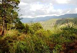
Situated within the Cordillera mountains, Benguet is dominantly mountainous. Mount Pulag, the highest in Luzon is located within Kabayan. The mountains form the headwaters of several rivers, the major ones which include the Agno, Amburayan, Bued, Bakun, Balili and the Asin. Some of these run through river valleys or gorges.
Several natural lakes, small in size, are found within the hinterlands. The largest are the "Four Lakes" in Kabayan; Lake Bulalacao, Lake Detepngepos, Lake Incolos and Lake Tabeyo.[28]
Climate
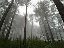
Most of Benguet falls under the subtropical highland climate (Köppen Cwb) zone, experiencing annual average highs of 25.3 °C (77.5 °F) in April and lows of 13.3 °C (55.9 °F) in January.[29]
The province suffers from crop damage resulting from seasonal frost during the cold months of December to March, especially in high-altitude towns such as Atok, Buguias, Mankayan and Kibungan.[30][31] In February 2007, Benguet suffered crop damage due to temperatures reaching as low as 7 °C (45 °F).[32]
| Climate data for Benguet | |||||||||||||
|---|---|---|---|---|---|---|---|---|---|---|---|---|---|
| Month | Jan | Feb | Mar | Apr | May | Jun | Jul | Aug | Sep | Oct | Nov | Dec | Year |
| Average high °C (°F) | 23.1 (73.6) |
23.9 (75.0) |
24.7 (76.5) |
25.3 (77.5) |
24.6 (76.3) |
24.1 (75.4) |
22.9 (73.2) |
22.5 (72.5) |
23 (73) |
23.6 (74.5) |
23.8 (74.8) |
23.3 (73.9) |
23.7 (74.7) |
| Average low °C (°F) | 13.3 (55.9) |
13.9 (57.0) |
14.8 (58.6) |
16.2 (61.2) |
16.7 (62.1) |
16.6 (61.9) |
16.4 (61.5) |
16.6 (61.9) |
16.3 (61.3) |
16 (61) |
15.5 (59.9) |
14.2 (57.6) |
15.5 (60.0) |
| Average precipitation mm (inches) | 150.8 (5.94) |
101.8 (4.01) |
82.3 (3.24) |
44.9 (1.77) |
132.5 (5.22) |
146 (5.7) |
196.9 (7.75) |
181.6 (7.15) |
168.5 (6.63) |
199.2 (7.84) |
191.2 (7.53) |
233.7 (9.20) |
1,829.4 (71.98) |
| Average rainy days | 2 | 3 | 6 | 9 | 19 | 21 | 26 | 26 | 23 | 14 | 9 | 5 | 163 |
| Source 1: Storm247 (for average temperature and rainy days)[29] | |||||||||||||
| Source 2: WorldWeatherOnline (for average precipitation)[33] | |||||||||||||
Administrative divisions
Benguet comprises 13 municipalities, all encompassed by double legislative districts.[27]
The highly urbanized city of Baguio, although administratively independent from Benguet, is situated in the interior of the province, surrounded by the municipalities of La Trinidad, Itogon, Sablan and Tuba. The city used to be part of the province but became independent when the city's charter was enacted in 1909.

|
| ||||||||||||||||||||||||||||||||||||||||||||||||||||||||||||||||||||||||||||||||||||||||||||||||||||||||||||||||||||||||||||||||||||||||||||||||||||||||||||||||||||||||||||||||||||||||||||||||||||||||||||||||||||||||||||||||||||||||||||||||||
Demographics
| Population census of Benguet | ||
|---|---|---|
| Year | Pop. | ±% p.a. |
| 1990 | 302,715 | — |
| 1995 | 313,833 | +0.68% |
| 2000 | 330,129 | +1.09% |
| 2007 | 372,533 | +1.68% |
| 2010 | 403,944 | +2.99% |
| 2015 | 446,224 | +1.91% |
| (excluding Baguio City) Source: Philippine Statistics Authority[4][34][35] | ||
The population of Benguet in the 2015 census was 446,224 people,[4] making it the most populous province in the region. It had a density of 160 inhabitants per square kilometre or 410 inhabitants per square mile. If the highly urbanized city of Baguio is included for geographical purposes, the population is 791,590, with a density of 280/km2 (725/sq mi).
In the May 2000 census, Benguet had a total population of 330,129. This figure is up by 16,296 from 313,833 persons recorded in the 1995 census, giving an annual growth rate of 1.09% during the 5-year period compared to the national average of 2.43%. The province registered 63,123 households, an increase of 4,588 households over the 1990 figure. This gave an average household size of 5.20 persons, slightly higher than the national average of 4.99.
| Ethnicity as of 2000[36] |
|---|
|

Ethnicity
The native inhabitants of Benguet comprise three ethnolinguistic groups. Kankanaeys dominate the northwestern municipalities, Ibalois are concentrated on the southeast, and Kalanguyas are mostly found in the east.[5][37][38] Migrants from lowland provinces have fused with the local populace to form a melting pot in some areas.[17][38][39]
According to the 2000 Philippine census, Kankanaeys comprised 42.96% (141,434) of the entire provincial household population of 329,216 at the time, while 29.15% (95,968) were identified as Ibalois, and 3.69% (12,147) were Ikalahan/Kalanguya. Major resident lowland ethnic groups included Ilocanos at 13.36% (43,984) and Tagalogs at 2.36% (7,773). Ilokano population arrived in the province after then president Marcos ordered an Ilokona migration towards the province in an attempt to solidify his administration's rule in northern Luzon. This resulted in ethnic land-grabbing of Ilokanos from indigenous Ibaloi, Kankanaey, and Kalanguya peoples. In 2002, the Ibaloi people formally retaliated against the Marcos-initiated exploitation of their lands by 'exorcising' the now-destroyed Bust of Ferdinand Marcos in La Union.[36]
Languages
Benguet residents generally speak their own languages in addition to Ilocano, Tagalog, and English, which are used for trade and commerce. The Ibaloi tribe speak Ibaloi, which is similar to Pangasinan, while the Kankanaey have their own eponymous language, which is related to the Bontoc language.
The SIL Ethnologue database classifies the languages under the South-Central Cordilleran branch. Nabaloy (named in the database as Ibaloi) is part of the Southern Cordilleran branch which also includes Pangasinense. The Kankanaey language is under the Central Cordilleran branch, which also includes Bontoc and Ifugao.[40]

Religion
Roman Catholicism is the predominant religion with 59% adherence.,[41] Protestants, especially Anglicans, Methodists, Baptists, and Evangelicals, form about 33% of the population,[42][43] while the Iglesia ni Cristo forms about 3%.[44] There is also small community of Muslims (0.472% of the province population).
Economy

Agriculture, mining, and tourism are the major industries in Benguet. Its cool climate and high altitude has made it an ideal place for producing highland vegetables. Benguet is often called the Salad Bowl of the Philippines.[2][5][38] The La Trinidad Vegetable Trading Post in the capital town of La Trinidad serves as the hub of vegetable trading in the province, attracting farmers, merchants and traders from the local community and the Philippines' different provinces.[45] Major crops produced which include potatoes, Baguio beans, peas, strawberries, cabbage, broccoli, cauliflower, lettuce, sayote and carrots are shipped throughout the country.[5][46][47][48]
Horticulture and floriculture are practiced in the province.[49] The province supplies flowers to the different municipalities, including Baguio City, as well as to Metro Manila, including other parts of Luzon, Visayas and Mindanao.[50][51][52] Roses are produced, particularly in Barangay Bahong in La Trinidad, earning the barangay the title Rose Capital of the Philippines.[53] Apisang (scientific name: Pittosporum resiniferum), a plant endemic to the Philippines, is grown in the municipalities of Kapangan and Kibungan as a potential alternative source of fuel and energy, rivaling the jatropha biofuel plant.[54][55]
Other agricultural-related activities are monggo processing, fruit preservation, peanut brittle manufacturing, broom making and basket weaving.[5][56]
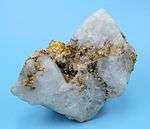
Mining is a major industry in Benguet, which is one of the country's leading gold producers.[5] The Benguet Corporation, the first and oldest mining company in the Philippines, has extracted gold, copper and chromite in Itogon since 1903.[57][58]
Other mineral deposits are silver, copper, pyrite, and limestone. Silver smithing is a large industry in Benguet, and many entrepreneurs sell silver works at lower prices in Baguio City compared to Manila. In 2006, revenues from mining reached 4 billion pesos from just two (Lepanto Consolidated Mining Corporation and Philex Mines) of many mining firms operating in the province. The province's mining vigor has never translated into better quality of life of the Benguet people, simply because a bulk of the mining firm's taxes are not paid directly to the province.[59] The two mining corporations, like many others around the country, have principal offices in the City of Makati, a set-up that makes Makati the prime mining tax beneficiary.
The location of Baguio City within Benguet draws many tourists from the lowlands. Often, people who go to Baguio also explore the province, especially the strawberry fields in La Trinidad.
Education
Higher education in the province is centered in the capital town of La Trinidad,[60] which houses the Main Campus of the only university in Benguet, the Benguet State University (BSU). The university has two satellite campuses in two municipalities; the Buguias Campus at Loo, Buguias, and the Bokod Campus at Ambangeg, Bokod.[61]
Other educational institutions which include Advocates Academic College, BVS Colleges, Cordillera Career Development College, King's College of the Philippines, Philippine College of Ministry, Philippine Nazarene College, as well as the Cordillera Regional Science High School, the Benguet National High School (with several annexes) and the Benguet SPED Center are also situated within La Trinidad.
The independent chartered city of Baguio hosts several higher education institutions, which include most notably the University of the Philippines Baguio, Saint Louis University, University of the Cordilleras (formerly Baguio Colleges Foundation), University of Baguio, Pines City Colleges, Baguio Central University, and Baguio School of Business and Technology, attracting students from across the Philippines.

Tourism
The province is a major tourist destination in the country,[1] with most of its tourist spots centered on culture and nature.[62] Baguio City's location within the province provides a boost to the tourism industry of the province.[63] Notable interesting places in the province include Mount Pulag along Kabayan, Kennon Road in Tuba, Ambuklao Dam in Bokod, Binga Dam in Itogon, strawberry and flower farms in La Trinidad, and the Palina and Naguey rice terraces in Atok.
Tuba and Tublay hot springs are usually flocked by local tourists from the neighboring provinces. Vegetable terraces can be seen along the Halsema Highway, especially during the growing season. Kabayan is known for its centuries-old mummies, while Buguias is visited for its hot springs and the Apo Anno.
References
- "Facts & Figures: Benguet Province". Philippine Statistics Authority - National Statistical Coordination Board - Cordillera Administrative Region. Retrieved 9 October 2014.
- "Cordillera Autonomous Region". It's More Fun in the Philippines. Archived from the original on 9 May 2013. Retrieved 17 September 2014.
- "List of Provinces". PSGC Interactive. Makati City, Philippines: National Statistical Coordination Board. Archived from the original on 19 April 2016. Retrieved 5 March 2020.
- Census of Population (2015). Highlights of the Philippine Population 2015 Census of Population. PSA. Retrieved 20 June 2016.
- Lancion, Jr., Conrado M.; de Guzman, Rey (cartography) (1995). "The Provinces". Fast Facts about Philippine Provinces (The 2000 Millenium ed.). Makati, Metro Manila: Tahanan Books. p. 38. ISBN 978-971-630-037-6. Retrieved 16 January 2015.
- Habana, Olivia M. (2000). "Gold Mining in Benguet to 1898" (PDF). Philippine Studies. Ateneo de Manila University • Loyola Heights, Quezon City • 1108 Philippines. 48: 458–467. Retrieved 13 October 2018.CS1 maint: location (link)
- Scott, William (1974). The Discovery of the Igorots. Quezon City: New Day Publishers. p. 149. ISBN 978-9711000875.
- Kane, S.E., 1933, Thirty Years with the Philippine Head-Hunters, New York: Grosset & Dunlap
- Lancion, Jr., Conrado M.; de Guzman, Rey (cartography) (1995). Fast Facts about Philippine Provinces (The 2000 Millenium ed.). Makati, Metro Manila: Tahanan Books. pp. 108–109. ISBN 978-971-630-037-6.
- "Facts & Figures: Mountain Province". Philippine Statistics Authority - National Statistical Coordination Board - Cordillera Administrative Region. Archived from the original on 1 September 2016. Retrieved 22 October 2014.
- "Municipality of La Trinidad, Benguet". DILG-CAR. Archived from the original on 21 January 2016. Retrieved 18 September 2014.
- "History: Benguet Province". Province of Benguet (official website). Archived from the original on 19 October 2014. Retrieved 9 October 2014.
- "LGU-Pugo-History". Provincial Government of La Union (official website). Archived from the original on 2016-03-06. Retrieved 3 October 2014.
(Note: Pugo was part of the municipal district of Benguet Province until February 4, 1920)
- "Act No. 1876". PhilippineLaw.info. 18 August 1908. Archived from the original on 2014-10-15. Retrieved 9 October 2014.
- "Municipality of Tuba, Benguet". Department of Interior and Local Government - Cordillera Administrative Region. Retrieved 4 October 2014.
- "Republic Act No. 4695: An Act Creating the Provinces of Benguet, Mountain Province, Ifugao and Kalinga-Apayao". Chan Robles Virtual Law Library. Retrieved 18 September 2014.
- "Benguet History". Province of Benguet (Official Website). Archived from the original on 19 October 2014. Retrieved 17 September 2014.
- "Presidential Decree No. 224; Amending Certain Parts of the Integrated Organization Plan". Chan Robles Virtual Law Library. Malacañang, Manila, Philippines. 22 June 1973. Archived from the original on 25 October 2013. Retrieved 30 September 2016.
- "Pampanga activists remember Martial Law".
- "Filipinos remember Martial Law: 'Dictatorship is back'".
- "Remembering Martial Law under the Marcos regime | Inquirer News".
- "Regional Profile: Cordillera Administrative Region (CAR)". CountrySTAT Philippines. Archived from the original on 22 October 2014. Retrieved 18 September 2014.
- "The Cordillera Administrative Region (CAR)". Department of Agriculture. Retrieved 18 September 2014.
- Polve, Mireille; Maury, Rene; Jego, Sebastien; Bellon, Jerve; Margoum, Ahmed; Yumul, Graciano; Payot, Betchaida; Tamayo, Rodolfo; Cotten, Joseph (2007). "Temporal Geochemical Evolution of Neogene Magmatism in the Baguio Gold-Copper Mining District (Northern Luzon, Philippines)". Resource Geology. 57 (2): 197–218. doi:10.1111/j.1751-3928.2007.00017.x.
- Fernandez, Henry; Damasco, Florian (1979). "Gold Deposition in the Baguio Gold District and Its Relationship to Regional Geology". Economic Geology. 74 (8): 1852–1868. doi:10.2113/gsecongeo.74.8.1852.
- Bagamaspad, Anavic; Hamada-Pawid, Zenaida (1985). A People's History of Benguet Province. Philippines: Baguio Printing & Publishing Company, Inc. pp. 72–76.
- "Province: Benguet". PSGC Interactive. Quezon City, Philippines: Philippine Statistics Authority. Retrieved 8 January 2016.
- Aro, SC (25 October 2008). "Mt Pulag climb slated October 31-November 2". Philippine Information Agency. Retrieved 29 February 2016.
From Tawangan where the trekkers will spend the second night, they will visit the four mystic lakes namely Tabeyo, Bulalacao, Incolos, and Detepngepos described as icy cool and crystal clear water and lush green foliage that refreshes the soul.
- "Weather forecast for Benguet, Philippines". Storm247. Retrieved 29 January 2016.
- Catajan, Maria Elena (2 January 2014). "Frost affects towns". Sun.Star Baguio. Retrieved 17 September 2014.
- Quitasol, Kimberlie (3 January 2014). "Frost descends on Benguet farms". Philippine Daily Inquirer. Retrieved 17 September 2014.
- Palangchao, Harley (2 February 2007). "Benguet Farmers Lose Crops to Frost". The Manila Times. Archived from the original on 24 September 2015. Retrieved 17 September 2014.
- "Benguet Monthly Climate Average, Philippines". World Weather Online. Retrieved 29 January 2016.
- Census of Population and Housing (2010). Population and Annual Growth Rates for The Philippines and Its Regions, Provinces, and Highly Urbanized Cities (PDF). NSO. Retrieved 29 June 2016.
- Census of Population and Housing (2010). "Cordillera Administrative Region (CAR)". Total Population by Province, City, Municipality and Barangay. NSO. Retrieved 29 June 2016.
- "Benguet: Dependency Ratio Down by Four Persons; Table 5. Household Population by Ethnicity and Sex: Benguet, 2000". Philippine Statistics Authority. 26 April 2002. Archived from the original on 21 April 2015. Retrieved 24 July 2016.
- "About Benguet Province, Philippines". IslandsWeb Online Services. Retrieved 17 September 2014.
- "Facts & Figures: Benguet Province". National Commission for Culture and the Arts. Retrieved 17 September 2014.
- "The Cordillera: Its Land and People". Cordillera Peoples Alliance. Retrieved 17 September 2014.
- "Austronesian". Ethnologue: Languages of the World. Retrieved 22 July 2016.
- "MAP: Catholicism in the Philippines".
- http://philchal.org/dawn/provinceupdates/Table%201_%20BENGUET2008.pdf
- http://psa.gov.ph/sites/default/files/attachments/hsd/specialrelease/Benguet_Statistical%20Tables.xls
- "MAP: Iglesia ni Cristo in the Philippines".
- Angela E. Obnial (December 2005). "La Trinidad veggie trading post revisited". Bureau of Agricultural Research Chronicle. Bureau of Agricultural Research. Archived from the original on 9 October 2014. Retrieved 17 September 2014.
- Agreda, JM (8 July 2015). "Highland vegetable prices increase in Benguet". CNN Philippines. Retrieved 29 February 2016.
Benguet produces more than 1.6 million kilograms of vegetables daily to Metro Manila and the rest of Luzon, Visayas and Mindanao. Benguet province currently supplies 80 percent of highland vegetables such as carrots, sayote, potatoes, lettuce, cabbage among other semi-temperate vegetables being sold in Metro Manila public markets and supermarkets.
- "Province of Benguet: Fast Facts". Province of Benguet website. Archived from the original on 23 September 2015. Retrieved 17 September 2014.
- Catajan, Maria Elena (24 December 2015). "Benguet ships 11 tons of vegetables for Christmas". Sun.Star Baguio. Retrieved 29 February 2016.
BENGUET farmers have shipped 2.5 million kilos of vegetables from Saturday to Tuesday as they try to keep out with bulk orders for the Christmas holiday. ... Benguet provides 80 percent of the country's vegetable needs. ... As many as 140 trucks haul vegetables from the Benguet Trading Post mainly to Metro Manila.
- Comanda, Zaldy (15 February 2014). "Benguet grows Holland tulips". Manila Bulletin. Retrieved 17 September 2014.
- Agreda, JM (30 October 2015). "Baguio flowers sell fast despite price increase". CNN Philippines. Retrieved 29 February 2016.
Majority of flowers sold in Dangwa in Metro Manila are being propagated in Benguet. The province produced more than 30 million metric tons of cut flowers in 2014, making it the top flower producer and supplier for most of Luzon including Metro Manila, Visayas and Mindanao and providing farmers of millions of pesos in earnings annually.
- "Benguet farmers harvest of tons of fresh flowers for All Saints Day". InterAksyon.com. Philippines News Agency. 29 October 2013. Retrieved 17 September 2014.
- Catajan, Ma. Elena (17 January 2013). "Benguet flowers ready for Panagbenga". Sun.Star Publishing, Inc. Retrieved 17 September 2014.
- Polonio, Jessa Mardy (27 February 2016). "Flower power in Bahong". Sun.Star Baguio. Retrieved 29 February 2016.
Aside from strawberries, the municipality of La Trinidad is also known for its flower growing villages where eco-farm tourism is being developed as a complimentary [sic] destination outside Baguio. The towns of La Trinidad, Atok, Tublay, Kapangan, Kibungan and Buguias have been producing cut flowers sold in several local markets around the country. Barangay Bahong in La Trinidad is dubbed as the famous flower growing community declared as the Rose Capital of the Philippines in 1998 by then Department of Agriculture Secretary William Dar.
- Dumlao, Artemio (23 August 2009). "Tree for alternative fuel found in Cordillera". The Philippine Star. Retrieved 17 September 2014.
- "Benguet finds oil treasure in 'petroleum nut'". Philippine Daily Inquirer. 2 July 2009. Archived from the original on 2015-01-16. Retrieved 17 September 2014.
- "The Pasalubong Map: Luzon". Choose Philippines. 14 April 2014. Retrieved 17 September 2014.
- "Benguet Corporation: Corporate Profile" (PDF). Retrieved 18 November 2014.
- "Benguet Corp". Bloomberg. Retrieved 17 September 2014.
- Cabreza, Vincent (20 October 2012). "Country's first mine town should have been richest in PH". Inquirer Northern Luzon. Retrieved 23 July 2016.
- "La Trinidad Now Rivals Baguio as Educational Center". Joseph. Goshen Land. 11 June 2015. Retrieved 22 July 2016.
- "Colleges, Institutes, & Campuses". Benguet State University. Retrieved 17 September 2014.
- Aro, Susan (3 June 2014). "Benguet tourism sites mostly culture, nature-based". Sun.Star Baguio. Philippine Information Agency. Retrieved 9 October 2014.
- Catajan, Maria Elena (7 April 2014). "Benguet tourist arrivals peak". Sun.Star Baguio. Retrieved 9 October 2014.
External links


Places adjacent to Benguet | |
|---|---|
La Trinidad (capital) | |
| Municipalities | |
| Highly urbanized city |
|
| Barangays | |
| Authority control |
|
|---|