Tapaz, Capiz
Tapaz, officially the Municipality of Tapaz, (Hiligaynon: Banwa sang Tapaz; Aklanon: Banwa it Tapaz; Kinaray-a: Banwa kang Tapaz/Banwa ka Tapaz; Tagalog: Bayan ng Tapaz), is a 1st class municipality in the province of Capiz, Philippines. According to the 2015 census, it has a population of 51,313 people.[3]
Tapaz | |
|---|---|
| Municipality of Tapaz | |
 St. Jerome Parish | |
 Flag  Seal | |
| Motto(s): Regnat Populus Dei ("The People of God Reigns") | |
| Anthem: "Tapaz Hymn" | |
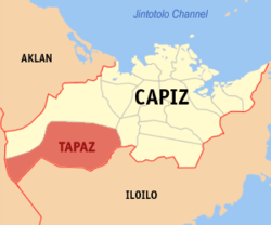 Map of Capiz with Tapaz highlighted | |
| |
.svg.png) Tapaz Location within the Philippines | |
| Coordinates: 11°16′N 122°32′E | |
| Country | |
| Region | Western Visayas (Region VI) |
| Province | Capiz |
| District | 2nd district of Capiz |
| Barangays | 57 (see Barangays) |
| Government | |
| • Type | Sangguniang Bayan |
| • Mayor | Roberto O. Palomar |
| • Vice Mayor | Ma. Fe G. Gardose |
| • Congressman | Fredenil H. Castro |
| • Electorate | 35,474 voters (2019) |
| Area | |
| • Total | 517.18 km2 (199.68 sq mi) |
| Elevation | 45.5 m (149.3 ft) |
| Highest elevation | 1,909 m (6,263 ft) |
| Population (2015 census)[3] | |
| • Total | 51,313 |
| • Density | 99/km2 (260/sq mi) |
| • Households | 12,094 |
| Demonym(s) | Tapaznon |
| Economy | |
| • Income class | 1st municipal income class |
| • Poverty incidence | 24.11% (2015)[4] |
| • Revenue (₱) | 157,207,592.25 (2016) |
| Time zone | UTC+8 (PST) |
| ZIP code | 5814 |
| PSGC | |
| IDD : area code | +63 (0)36 |
| Climate type | tropical climate |
| Native languages | Sulod Kinaray-a language Capiznon Hiligaynon Tagalog |
| Website | www |
The festival in Tapaz are the Patabang Festival in September honoring Patron Saint Jerome, and Sirinadya in January honoring Sr. Santo Niño. Other local festival is Tinuom Festival in San Nicholas celebrated in the Month of December honoring Patron Saint Nicolas of Myra.
The natives of Tapaz are mixture of several ethnic groups as the Malays, Spaniards, Indonesians, and the Aetas or Negritos who are the aborigines of Panay. In the recent years the residents are distincts group as the "Baludnons" those in lowland and "Bukidnons" those in upland.
The town is known for a small community of indigenous Panay-Bukidnon in Barangay Tacayan. The community is home to Feliza, a binukot who has expertise in chanting the suguidanon, one of the most significant epic chants of the Western Visayas region. Feliza is the last known person who can speak the Ligbok language in her community, making her the last bastion for the thousand-year old language in Tapaz. Her death would translate to the death of the language in Tapaz itself and the suguidanon epic chant as well. Also, Feliza has traditional tattoos on her skin which were inscribed when she was chosen as a binukot. In 2016, after reports came out on the dying Ligbok language and suguidanon epic chant, the government began documenting the language and epic chant and teaching the language to younger generations of Panay-Bukidnon in Tapaz.[5]
Marugo lake in San Antonio barangay is most popular tourist destination.
History
The first people who arrived and settled in what is now Tapaz are the Panay-Bukidnon people who speak the indigenous Ligbok language.
When the Spanish arrived in Panay, they established Dumalag town. Eventually, Tapaz was founded in 1835 but it continued being a part of Dumalag town for many years. In 1862 and 1863 two letters were made to declare parish under the patronage of St. Jerome. Both were signed by Governor General Lemery, but they were never executed. Finally, in 1874, Tapaz was declared an independent parish by Jaro Bishop Mariano Cuartero.
In 2016, the Ligbok language of the Panay-Bukidnon of Tapaz was confirmed to be dying out. This triggered a massive conservation program for the language and the epic chant spoken by the Panay-Bukidnon.[6]
Geography
Tapaz lies within the latitude 11° 09’ to 11° 09’ 42" and the longitude of 121° 11’ to 122° 34’ 45". It is 55 kilometres (34 mi) from Roxas City.
Climate
| Climate data for Tapaz, Capiz | |||||||||||||
|---|---|---|---|---|---|---|---|---|---|---|---|---|---|
| Month | Jan | Feb | Mar | Apr | May | Jun | Jul | Aug | Sep | Oct | Nov | Dec | Year |
| Average high °C (°F) | 28 (82) |
29 (84) |
31 (88) |
32 (90) |
32 (90) |
30 (86) |
29 (84) |
29 (84) |
29 (84) |
29 (84) |
29 (84) |
28 (82) |
30 (85) |
| Average low °C (°F) | 22 (72) |
22 (72) |
22 (72) |
23 (73) |
25 (77) |
25 (77) |
25 (77) |
25 (77) |
25 (77) |
24 (75) |
23 (73) |
23 (73) |
24 (75) |
| Average precipitation mm (inches) | 64 (2.5) |
44 (1.7) |
58 (2.3) |
83 (3.3) |
204 (8.0) |
304 (12.0) |
334 (13.1) |
291 (11.5) |
310 (12.2) |
281 (11.1) |
172 (6.8) |
97 (3.8) |
2,242 (88.3) |
| Average rainy days | 12.5 | 8.9 | 11.3 | 14.1 | 24.2 | 28.0 | 29.6 | 28.2 | 28.1 | 28.1 | 20.2 | 15.2 | 248.4 |
| Source: Meteoblue [7] | |||||||||||||
Barangays
Tapaz is politically subdivided into 58 barangays. [2] Thirty Six (36) lowlands barangays and Twenty Two (22) upland barangays.
- Abangay
- Acuña
- Agcococ
- Aglinab
- Aglupacan
- Agpalali
- Apero
- Artuz
- Bag-Ong Barrio
- Bato-bato
- Buri
- Camburanan
- Candelaria
- Carida
- Cristina
- Da-an Banwa
- Da-an Norte
- Da-an Sur
- Garcia
- Gebio-an
- Hilwan
- Initan
- Katipunan
- Lagdungan
- Lahug
- Libertad
- Mabini
- Maliao
- Malitbog
- Minan
- Nayawan
- Poblacion
- Rizal Norte
- Rizal Sur
- Roosevelt
- Roxas
- Salong
- San Antonio
- San Francisco
- San Jose
- San Julian
- San Miguel Ilawod
- San Miguel Ilaya
- San Nicolas
- San Pedro
- San Roque
- San Vicente
- Santa Ana
- Santa Petronila
- Senonod
- Siya
- Switch
- Tabon
- Tacayan
- Taft
- Taganghin
- Taslan
- Wright
Education
The increasing population of school children made the District of Tapaz into two distincts. The Tapaz East District with 22 complete Elementary Schools and 14 Primary Schools. The Tapaz West District with 19 complete Elementary Schools and 3 Primary Schools. It has 8 Secondary Schools and one University that caters the tertiary education of Tapaznon.
High schools
High Schools in Tapaz
- Bag-ong Barrio National High School
- Camburanan National High School
- Candelaria National High School
- Col. Patrociño Artuz National High School
- Rev. Tomas Conejar National High School
- Roxas National High School
- San Nicolas National High School
- Tapaz National High School
Demographics
| Population census of Tapaz | ||
|---|---|---|
| Year | Pop. | ±% p.a. |
| 1903 | 3,741 | — |
| 1918 | 11,242 | +7.61% |
| 1939 | 17,047 | +2.00% |
| 1948 | 10,898 | −4.85% |
| 1960 | 12,649 | +1.25% |
| 1970 | 15,911 | +2.32% |
| 1975 | 18,536 | +3.11% |
| 1980 | 20,043 | +1.58% |
| 1990 | 40,942 | +7.41% |
| 1995 | 40,809 | −0.06% |
| 2000 | 44,085 | +1.67% |
| 2007 | 47,059 | +0.90% |
| 2010 | 48,051 | +0.76% |
| 2015 | 51,313 | +1.26% |
| Source: Philippine Statistics Authority[3][8][9][10] | ||
In the 2015 census, the population of Tapaz was 51,313 people,[3] with a density of 99 inhabitants per square kilometre or 260 inhabitants per square mile.
Religion
As a Catholic Dominant Municipality. Tapaz has two Parishes, Three Mission Stations and Many Churches.
Parishes

- St. Jerome Parish (Poblacion, Tapaz)
- St. Nicholas of Myra Parish (San Nicolas, Tapaz)
Mission Stations
- St. Andre Besette Mission Station (Taft, Tapaz)
- St. Juan Diego Mission Station (Cristina, Tapaz)
- St. Julian of Cuenca Mission Station (San Julian, Tapaz)
References
- "Municipality". Quezon City, Philippines: Department of the Interior and Local Government. Retrieved 31 May 2013.
- "Province: Capiz". PSGC Interactive. Quezon City, Philippines: Philippine Statistics Authority. Retrieved 12 November 2016.
- Census of Population (2015). "Region VI (Western Visayas)". Total Population by Province, City, Municipality and Barangay. PSA. Retrieved 20 June 2016.
- "PSA releases the 2015 Municipal and City Level Poverty Estimates". Quezon City, Philippines. Retrieved 12 October 2019.
- https://www.youtube.com/watch?v=oR8ApbrjA-s
- https://www.youtube.com/watch?v=oR8ApbrjA-s
- "Tapaz: Average Temperatures and Rainfall". Meteoblue. Retrieved 2 May 2020.
- Census of Population and Housing (2010). "Region VI (Western Visayas)". Total Population by Province, City, Municipality and Barangay. NSO. Retrieved 29 June 2016.
- Censuses of Population (1903–2007). "Region VI (Western Visayas)". Table 1. Population Enumerated in Various Censuses by Province/Highly Urbanized City: 1903 to 2007. NSO.
- "Province of Capiz". Municipality Population Data. Local Water Utilities Administration Research Division. Retrieved 17 December 2016.
External links
Places adjacent to Tapaz, Capiz | ||||||||||
|---|---|---|---|---|---|---|---|---|---|---|
| ||||||||||