Abra (province)
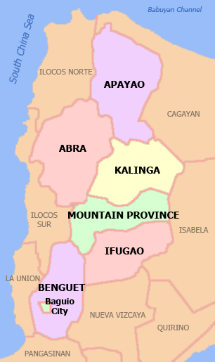
Abra (Ilocano: Probinsia ti Abra; Tagalog: Lalawigan ng Abra) is a landlocked province of the Philippines in the Cordillera Administrative Region in Luzon. Its capital is Bangued, and is bordered by Ilocos Norte on the northwest, Apayao on the northeast, Kalinga on the mid-east, Mountain Province on the southeast, and Ilocos Sur on the southwest.
Abra | |
|---|---|
| Province of Abra | |
 Abra Provincial Capitol | |
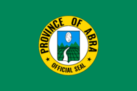 Flag  Seal | |
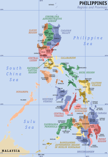
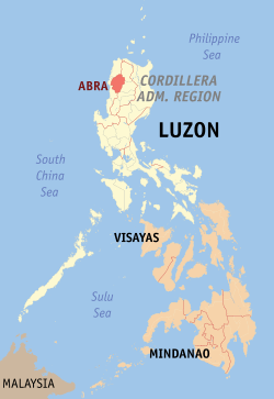 Location in the Philippines | |
| Coordinates: 17°35′N 120°45′E | |
| Region | Cordillera Administrative Region (CAR) |
| Founded | 10 March 1917 |
| Capital | Bangued |
| Government | |
| • Type | Sangguniang Panlalawigan |
| • Governor | Maria Jocelyn Acosta Valera-Bernos (NUP/HNP) |
| • Vice Governor | Ronald Stimson Balao-as (NUP) |
| Area | |
| • Total | 4,165.25 km2 (1,608.21 sq mi) |
| Area rank | 29th out of 81 |
| Highest elevation (Mount Bangbanglang) | 2,454 m (8,051 ft) |
| Population (2015 census)[2] | |
| • Total | 241,160 |
| • Rank | 68th out of 81 |
| • Density | 58/km2 (150/sq mi) |
| • Density rank | 80th out of 81 |
| Divisions | |
| • Independent cities | 0 |
| • Component cities | 0 |
| • Municipalities | |
| • Barangays | 303 |
| • Districts | Lone District of Abra |
| Time zone | UTC+8 (PHT) |
| ZIP code | 2800–2826 |
| IDD : area code | +63 (0)74 |
| ISO 3166 code | PH |
| Spoken languages | |
| Website | www |
History
Pre-colonial period
The first inhabitants of Abra were the ancestors of the Bontocs and the Ifugaos. These inhabitants eventually left to settle in the old Mountain Province. Other early inhabitants were the Tingguians, or Itnegs, as they are also known.
Spanish era
In 1598, a Spanish garrison was established in Bangued to protect Christian Ilocanos from Tingguian raids. Originally the area was called El Abra de Vigan ("The Opening of Vigan"). During the British Occupation of the Philippines, Gabriela Silang and her army fled to Abra from Ilocos and continued the revolt begun by her slain husband, Diego Silang. She was captured and hanged by the Spanish in 1763.
In 1818, the Ilocos region, including Abra, was divided into Ilocos Norte and Ilocos Sur. In 1846, Abra was created[3] as a political-military province with Lepanto as a sub-province. It remained so until the arrival of the Americans in 1899.
American period
In 1908, the Philippine Commission again annexed Abra to Ilocos Sur in an attempt to resolve Abra's financial difficulties. On March 9, 1917, the Philippine Assembly re-established Abra as a province.[4]
World War II
In 1942, the Japanese forces occupied the Philippines and entered Abra.
Abra was liberated by the Philippine Commonwealth forces and local Cordilleran guerrillas during the Battle of Abra in 1945, at the end of the Second World War.
Modern history
The revolutionary Marxist priest, Conrado Balweg, who fought for the rights of the Cordillera tribes, began his crusade in Abra. After successfully negotiating a peace accord with Balweg's group in 1987, the Philippine government created the Cordillera Administrative Region, which includes Abra.[5]
Geography
Abra is situated in the mid-western section of the Cordillera Administrative Region in Luzon. It is bordered by the provinces of Ilocos Norte on the northwest, Apayao on the northeast, Kalinga on the mid-east, Mountain Province on the southeast, and Ilocos Sur on the southwest. Abra has a total land area of 4,165.25 square kilometres or 1,608.21 square miles[6].
The province is hemmed in by the towering mountain ranges of the Ilocos in the west and the Cordillera Central in the east. The Abra River runs from the south in Benguet to the west and central areas, bisecting the whole Abra Valley. It is joined by the Tineg River originating from the eastern uplands at a point near the municipality of Dolores.
Administrative divisions
Abra comprises 27 municipalities, all encompassed by a single legislative district.[6]

| Municipality [lower-roman 1][lower-roman 2] | Population | ±% p.a. | Area[6] | Density (2015) | Barangay | |||||||
|---|---|---|---|---|---|---|---|---|---|---|---|---|
| (2015)[2] | (2010)[7] | km2 | sq mi | /km2 | /sq mi | |||||||
| Bangued | † | 20.0% | 48,163 | 43,936 | +1.76% | 105.70 | 40.81 | 460 | 1,200 | 31 | ||
| Boliney | 1.5% | 3,573 | 4,063 | −2.42% | 216.92 | 83.75 | 16 | 41 | 8 | |||
| Bucay | 7.1% | 17,115 | 17,126 | −0.01% | 107.17 | 41.38 | 160 | 410 | 21 | |||
| Bucloc | 1.0% | 2,501 | 2,176 | +2.69% | 63.77 | 24.62 | 39 | 100 | 4 | |||
| Daguioman | 0.9% | 2,088 | 1,715 | +3.82% | 114.37 | 44.16 | 18 | 47 | 4 | |||
| Danglas | 1.7% | 4,192 | 4,734 | −2.29% | 156.02 | 60.24 | 27 | 70 | 7 | |||
| Dolores | 4.7% | 11,315 | 11,499 | −0.31% | 47.45 | 18.32 | 240 | 620 | 15 | |||
| La Paz | 6.4% | 15,437 | 14,882 | +0.70% | 51.41 | 19.85 | 300 | 780 | 12 | |||
| Lacub | 1.4% | 3,403 | 2,977 | +2.58% | 295.30 | 114.02 | 12 | 31 | 6 | |||
| Lagangilang | 5.9% | 14,255 | 13,824 | +0.59% | 101.44 | 39.17 | 140 | 360 | 17 | |||
| Lagayan | 1.9% | 4,499 | 4,477 | +0.09% | 215.97 | 83.39 | 21 | 54 | 5 | |||
| Langiden | 1.3% | 3,198 | 3,170 | +0.17% | 116.29 | 44.90 | 28 | 73 | 6 | |||
| Licuan-Baay (Licuan) | 1.9% | 4,689 | 4,864 | −0.70% | 256.42 | 99.00 | 18 | 47 | 11 | |||
| Luba | 2.6% | 6,339 | 6,391 | −0.16% | 148.27 | 57.25 | 43 | 110 | 8 | |||
| Malibcong | 1.4% | 3,428 | 3,807 | −1.98% | 283.17 | 109.33 | 12 | 31 | 12 | |||
| Manabo | 4.5% | 10,761 | 10,756 | +0.01% | 110.95 | 42.84 | 97 | 250 | 11 | |||
| Peñarrubia | 2.8% | 6,640 | 6,544 | +0.28% | 38.29 | 14.78 | 170 | 440 | 9 | |||
| Pidigan | 5.1% | 12,185 | 11,528 | +1.06% | 49.15 | 18.98 | 250 | 650 | 15 | |||
| Pilar | 4.2% | 10,223 | 9,908 | +0.60% | 66.10 | 25.52 | 150 | 390 | 19 | |||
| Sallapadan | 2.7% | 6,622 | 5,985 | +1.94% | 128.62 | 49.66 | 51 | 130 | 9 | |||
| San Isidro | 1.9% | 4,574 | 4,888 | −1.26% | 48.07 | 18.56 | 95 | 250 | 9 | |||
| San Juan | 4.1% | 9,867 | 10,546 | −1.26% | 64.08 | 24.74 | 150 | 390 | 19 | |||
| San Quintin | 2.3% | 5,438 | 5,233 | +0.73% | 66.59 | 25.71 | 82 | 210 | 6 | |||
| Tayum | 6.0% | 14,467 | 13,940 | +0.71% | 61.14 | 23.61 | 240 | 620 | 11 | |||
| Tineg | 2.1% | 5,097 | 4,668 | +1.69% | 744.80 | 287.57 | 6.8 | 18 | 10 | |||
| Tubo | 2.4% | 5,699 | 5,719 | −0.07% | 409.87 | 158.25 | 14 | 36 | 10 | |||
| Villaviciosa | 2.2% | 5,392 | 5,377 | +0.05% | 102.93 | 39.74 | 52 | 130 | 8 | |||
| Total | 241,160 | 234,733 | +0.52% | 4,165.25 | 1,608.21 | 56 | 150 | 303 | ||||
| † Provincial capital | Municipality | |||||||||||
| ||||||||||||
Demographics
The population of Abra in the 2015 census was 241,160 people,[2] with a density of 58 inhabitants per square kilometre or 150 inhabitants per square mile.
Abra's inhabitants are mostly descendants of Ilocano settlers and members of the Tingguian tribe. Based on the 2000 census survey, Ilocanos comprised 71.94% (150,457) of the total provincial population of 209,146. Tingguians came in second at 18.7% (39,115), while other ethnic groups in the province were the Ibanag at 4.46% (9,334), Itneg at 3.17% (6,624), and Tagalog at 0.42% (869).[8]
The predominant languages are Ilocano[9] and Itneg.[10]
| Population census of Abra | ||
|---|---|---|
| Year | Pop. | ±% p.a. |
| 1990 | 184,743 | — |
| 1995 | 195,964 | +1.11% |
| 2000 | 209,491 | +1.44% |
| 2007 | 230,953 | +1.35% |
| 2010 | 234,733 | +0.59% |
| 2015 | 241,160 | +0.52% |
| Source: PSA[2][7][11] | ||

Economy
As of 1990, there were 743 cottage industries in Abra, of which 208 are registered with the Department of Trade and Industry. 59% are engaged in bamboo and rattan craft making, both leading industries in the area.
Abra's economy is agriculture-based. Its major crops are rice, corn, and vegetables, root crops; commercial products include coffee, tobacco, and coconut. Extensive grassland and pasture areas are used for livestock production.
References
- "List of Provinces". PSGC Interactive. Makati City, Philippines: National Statistical Coordination Board. Archived from the original on 19 April 2016. Retrieved 14 May 2014.
- Census of Population (2015). "Cordillera Administrative Region (CAR)". Total Population by Province, City, Municipality and Barangay. PSA. Retrieved 20 June 2016.
- Fernández, Leandro Heriberto (1919). A Brief History of the Philippines. Ginn. p. 195.
- "Act No. 2683; An Act to Authorize the Segregation of the Subprovince of Abra from the Province of Ilocos Sur and the Reestablishment of the Former Province of Abra, and for Other Purposes". Supreme Court E-Library. 9 March 1917. Retrieved 18 March 2016.
- "Executive Order No. 220; Creating a Cordillera Administrative Region, Appropriating Funds Therefor and for Other Purposes". The LawPhil Project. Manila, Philippines. 15 July 1987. Retrieved 29 July 2016.
Sec. 2. Territorial Coverage. For purposes of the CAR, the region shall consist of the provinces of Abra, Benguet, Ifugao, Kalinga-Apayao and Mt. Province and the chartered city of Baguio. Until otherwise provided by the Cordillera Executive Board (CEB), the seat of the CAR shall be Baguio City.
- "Province: Abra (province)". PSGC Interactive. Quezon City, Philippines: Philippine Statistics Authority. Retrieved 8 January 2016.
- Census of Population and Housing (2010). "Cordillera Administrative Region (CAR)". Total Population by Province, City, Municipality and Barangay. NSO. Retrieved 29 June 2016.
- "Abra: Housing Unit Occupancy Rate Nears 100%; Table 5. Household Population by Ethnicity and Sex: Abra, 2000". Philippine Statistics Authority. 3 April 2002. Archived from the original on 5 March 2012. Retrieved 4 December 2015.
- Dalby, Andrew (2004-02-18). Dictionary of Languages: The Definitive Reference to More Than 400 Languages. Columbia University Press. p. 264. ISBN 978-0-231-11569-8.
- Tryon, Darrell T. (1994). Comparative Austronesian Dictionary: An Introduction to Austronesian Studies. Ratzlow-Druck. p. 171. ISBN 3-11-012729-6.
- Census of Population and Housing (2010). Population and Annual Growth Rates for The Philippines and Its Regions, Provinces, and Highly Urbanized Cities (PDF). NSO. Retrieved 29 June 2016.
External links
| Wikivoyage has a travel guide for Abra. |


- History articles and links on Bucay and Abra
Places adjacent to Abra (province) | |
|---|---|
Bangued' (capital) | |
| Municipalities | |
| Barangays | See: List of barangays in Abra |
| Authority control |
|
|---|