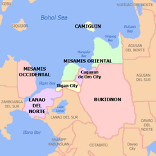
Misamis Occidental
Misamis Occidental (Cebuano: Kasadpang Misamis; Subanen: Sindepan Mis'samis) is a province located in the region of Northern Mindanao in the Philippines. Its capital is the city of Oroquieta. The province borders Zamboanga del Norte and Zamboanga del Sur to the west and is separated from Lanao del Norte by Panguil Bay to the south and Iligan Bay to the east. The province of Misamis was originally inhabited by Subanens who were an easy target by the sea pirates from Lanao.
Misamis Occidental | |
|---|---|
 Flag  Seal | |
| Nickname(s): Mis Occ | |
 Location in the Philippines | |
| Coordinates: 8°20′N 123°42′E | |
| Country | Philippines |
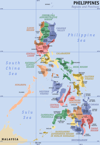
| Region | Northern Mindanao (Region X) |
| Founded | November 2, 1929[1] |
| Capital | Oroquieta |
| Government | |
| • Type | Sangguniang Panlalawigan |
| • Governor | Philip T. Tan |
| • Vice Governor | Aurora Virginia M. Almonte |
| Area | |
| • Total | 2,055.22 km2 (793.52 sq mi) |
| Area rank | 60th out of 81 |
| Highest elevation | 2,404 m (7,887 ft) |
| Population (2015 census)[3] | |
| • Total | 602,126 |
| • Rank | 47th out of 81 |
| • Density | 290/km2 (760/sq mi) |
| • Density rank | 26th out of 81 |
| Divisions | |
| • Independent cities | 0 |
| • Component cities | |
| • Municipalities | |
| • Barangays | 490 |
| • Districts | 1st and 2nd Districts of Misamis Occidental |
| Time zone | UTC+8 (PST) |
| ZIP code | 7200–7215 |
| IDD : area code | +63 (0)88 |
| ISO 3166 code | PH |
| Spoken languages | |
| Income classification | 2nd class |
| Website | misocc |
The province is named after the early settlement of the Spaniards at the entrance to the Panguil Bay. The name Misamis is believed to have been derived from the Subanen word Kuyamis which is a variety of coconut, the staple food of the early settlers. During the years the name persisted as an inference of the geographical location, and upon the advent of the Spanish settlers, the word kuyamis easily gave way to the more convenient pronounceable but corrupted word Misamis.[4]
History
The area of now Misamis Occidental was first occupied by Subanen and later Visayans settled in the coastal areas. The name Misamis is derived from Subanen word kuyamis which is a variety of coconut. During the 1750s was the time that the coastal villages in Southern Luzon, Visayas and Mindanao suffered attacks from bands of Muslim pirates, who burned houses and crops, and captured people to be sold as slaves in Maguindanao, Sulu, Borneo or the islands now known as Indonesia. In response, the colonial government in Manila created a flotilla and appointed a Spanish Jesuit missionary, José Ducos, as its commander.
After several successful battles against the pirates, when some peace had been restored, it was decided to build a stone fort at the mouth of Panguil Bay, at a place called Misamis, and Ducos was put in charge of the construction. The construction began in 1756. It was officially called “Fuerte de la Concepción y del Triunfo.”[5]
- Maps of Misamis, before its division into two provinces
 in 1880
 in 1899
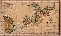 in 1918
- 1818 — Mindanao was organized into five politico-military districts, one of which was the Segundo Distrito de Misamis, the largest district in Mindanao. This area was composed of today’s Misamis Oriental, Misamis Occidental, Camiguin, Bukidnon, Lanao, Zamboanga del Norte, and the northern part of Cotabato.
- 1850 — the town of Misamis became the capital of the district of Misamis until February 27, 1872 when the Spanish Governor General Carlos María de la Torre y Navacerrada issued a decree declaring Cagayan the permanent capital of Segundo Distrito de Misamis. During this era, the name of the town was Cagayan de Misamis.
- November 2, 1929 — Legislative Act No. 3537 passed, dividing the old province of Misamis into Misamis Occidental and Misamis Oriental, which took effect on January 1, 1930. Misamis Occidental comprised the original nine towns of Baliangao, Lopez Jaena, Tudela, Clarin, Plaridel, Oroquieta, Aloran, Jimenez, and Misamis. Don Jose Fortich Ozamiz became the first governor.
- January 6, 1930 — the provincial council of Misamis Occidental, selected Oroquieta to become the capital town (cabecera) of the province.[6]
- 1935 — the Provincial Capitol Building, commonly called Capitolio, begun and became the seat of executive and legislative power of the province, in the town of Oroquieta.
- In 1942, the Japanese Imperial forces landed in Misamis Occidental, beginning their brief occupation of the province during World War II. In 1945, combined American and Philippine Commonwealth forces liberated the province, and with the help of the recognized guerilla units, defeated the Japanese forces. During World War II, Misamis became the capital of the Free Philippines as the seat of government of the Free Philippines then was the Capitolio. The United States Forces in the Philippines (USFIP) under Col. Wendell Fertig based in Misamis Occidental, was the rallying point for the guerrillas in Mindanao. This was historically significant because it is the only time in Philippine history when its capital was in Mindanao, in the region then known as Misamis. The Free Philippine Government was then issuing Misamis Occidental emergency notes. Late President Quezon, upon knowing that Oroquieta was made a capital of the Free Philippines and that the town was issuing emergency notes, authorized the Printing of the Mindanao emergency note.
- July 16, 1948 — the town of Misamis became a chartered city by virtue of Republic Act 321,[7] making the 4th city in Mindanao after Zamboanga, Davao and Marawi, also renamed Misamis to Ozamiz after a World War II hero José Ozámiz who hailed from the province of Misamis Occidental and who at one time also served as its governor and congressional representative of the Lone District of Misamis Occidental, Senator of the Philippines, a delegate to the 1935 Constitutional Convention that resulted in the creation of the 1935 Constitution for the Philippine Commonwealth Government.
- May 2010 — the people of Misamis Occidental elected their first lady governor, Herminia M. Ramiro.
Geography
Misamis Occidental is located near the narrow strip of land linking Northwestern Mindanao, to the North-central part of the island. Covering a total area of 2,055.22 square kilometres (793.52 sq mi)[8], the province is bounded on the northeast by the Mindanao Sea, east by the Iligan Bay, southeast by the Panguil Bay, and the west by the Zamboanga del Norte and Sur. Except along the coastal area, hilly and rolling land characterized the provincial terrain. Towards the western border, the terrain is particularly rugged.
Administrative divisions
Misamis Occidental comprises 14 municipalities and 3 component cities, which are organized into two legislative districts and further subdivided into 490 barangays.

- † Provincial capital and component city
- ∗ Component city
- Municipality
| ||||||||||||||||||||||||||||||||||||||||||||||||||||||||||||||||||||||||||||||||||||||||||||||||||||||||||||||||||||||||||||||||||||||||||||||||||||||||||||||||||||||||||||||||||||||||||||||||||||||||||||||||||||||||||||||||||||||||||||||||||||||||||||||||||||||||||
Demographics
| Population census of Misamis Occidental | ||
|---|---|---|
| Year | Pop. | ±% p.a. |
| 1960 | 248,371 | — |
| 1970 | 319,855 | +2.56% |
| 1990 | 424,365 | +1.42% |
| 1995 | 458,965 | +1.48% |
| 2000 | 486,723 | +1.27% |
| 2007 | 531,680 | +1.23% |
| 2010 | 567,642 | +2.41% |
| 2015 | 602,126 | +1.13% |
| Source: Philippine Statistics Authority[3][9][9] | ||
The population of Misamis Occidental in the 2015 census was 602,126 people,[3] with a density of 290 inhabitants per square kilometre or 750 inhabitants per square mile.
The dense population along the coast consists mainly of ethnic Cebuanos. Thus, Cebuano is the lingua franca of the province. Most of the native Subanens live in the interior uplands.
Religion
In 2013, Roman Catholicism remains the predominant faith of the people of Misamis Occidental having 70 percent affiliation and the second most members are with the Iglesia Filipina Independiente or Aglipayan Church with 20% while several Protestant Churches as well as Islam are the minorities.
Economy
The province economy depends firstly on fishing, secondly on coconuts, thirdly on rice. The province has 169 kilometres (105 mi) of coastline fronting the rich fishing grounds of Panguil and Iligan bays. It also has the biggest area of brackish water fishponds in the region. Tangub City is a fishing port on Panguil Bay famous for seafood. Coconut is the chief crop. This is processed into oil, desiccated coconut, and coir, most of which are shipped to Cebu. Coconut processing is the main industry in Oroquieta City. Other crops grown are rice, corn, abaca, coffee, cacao and rubber.
Resources
Wood is the major forest product. Predominant species are the lauan group, apitong, tanguige yakal, and Philippine mahogany. There is also an abundant supply of bamboo, rattan and various vines. Forest land in the province has an area of 66,002.46 hectares; 53,262 hectares of which are considered a national park (which has legal implications).
The province has a considerable deposit of clay especially in the municipalities of Lopez Jaena and Concepcion. Plaridel is the largest in rice production, and the longest coastal town in the province.
There are also an abundant sources of sand and gravel.
The province is traditionally a net exporter of various commodities. Historical data from the Ozamiz Port District of the Bureau of Customs show that outgoing commodities, which is mainly of coconut products, far outweigh incoming cargoes.
Being a coco-based province, major manufacturing firms in Misamis Occidental are engaged in the production of crude coconut oil, cooking oil, lard, margarine, laundry soap and desiccated coconut. Other products are furniture, ceramics gifts toys and housewares, processed food like banana chips and marine products.
Locally fabricated agri-industrial machines and equipment are also available in the province.
Tourism and attractions
- Langaranan Festival Plaridel, Misamis Occidental
- Baobaon Islets Plaridel, Misamis Occidental
- Shang's Resort Plaridel, Misamis Occidental
- Century-Old Nazareno Dam Plaridel, Misamis Occidental
- Caluya Shrine Sapang Dalaga, Misamis Occidental
- Baliangao Protected Landscape and Seascape
- Binalbal Festival, Tudela, Misamis Occidental
- Christmas Symbols Festival, Tangub City
- Dalit Festival, Tangub City
- Dampawan Festival, Concepcion, Misamis Occidental - September
- Fuerte dela Concepcion y del Triunfo
- Hoyohoy Highland Stone Chapel & Adventure Park, Tangub City
- Immaculate Conception Cathedral Pipe Organ, Ozamiz City
- Inug-og Festival, Oroquieta City
- Misamis Occidental Aquamarine Park
- Mount Malindang Range Natural Park and Lake Duminagat
- Pas'ungko S'g Mis. Occ. Festival of all Festivals - November
- Sapang Dalaga Falls
- Suman Festival, Clarin,Misamis Occidental - Clarin, the Suman Capital of Misamis Occidental
- Sinakbang Festival, Sinacaban, Misamis Occidental
Government
Congressman:
- 1st District: Rep. Diego "Nonoy" C. Ty
- 2nd District: Rep. Henry "Henz" S. Oaminal
Governor:
- Philip T. Tan
Vice Governor:
- Aurora Virginia "Jiejie" M. Almonte
Board Members:
|
|
|
Former governors
- Diego Ty Deling
- Anselmo Bernad
- Gella Caay
- Loreto Leo S. Ocampos
- José Ozámiz
- Gedeon G. Quijano
- Henry Y. Regalado Sr.
- Atty. Ernie D. Clarete
- Gorgonio F. Buaquiña II
- William Chiongbian
- Benito Chiongbian
- Fortunato Sagrado
See also
- Laguindingan Airport, the first international airport in Northern Mindanao region.
References
- "Act No. 3537". Philippine Supreme Court e-Library. Retrieved 20 October 2017.
- "List of Provinces". PSGC Interactive. Makati City, Philippines: National Statistical Coordination Board. Archived from the original on 21 January 2013. Retrieved 10 July 2014.
- Census of Population (2015). "Region X (Northern Mindanao)". Total Population by Province, City, Municipality and Barangay. PSA. Retrieved 20 June 2016.
- "Archived copy". Archived from the original on 2011-08-31. Retrieved 2010-06-10.CS1 maint: archived copy as title (link)
- BERNAD, M.. Father Ducos and the Muslim Wars, 1752-1759. Philippine Studies: Historical and Ethnographic Viewpoints, North America, 16, dec. 1968. Available at: <http://philippinestudies.net/ojs/index.php/ps/article/view/2272/4273>. Date accessed: 10 Feb. 2015.
- "Archived copy". Archived from the original on 2015-02-11. Retrieved 2015-02-10.CS1 maint: archived copy as title (link)
- "Republic Act No. 321 - An Act Creating the City of Ozamiz". Chan Robles Virtual Law Library. Retrieved 28 December 2015.
- "Province: Misamis Occidental". PSGC Interactive. Quezon City, Philippines: Philippine Statistics Authority. Retrieved 8 January 2016.
- Census of Population and Housing (2010). "Region X (Northern Mindanao)". Total Population by Province, City, Municipality and Barangay. NSO. Retrieved 29 June 2016.
External links


- Official website
- Philippine Standard Geographic Code
- Local Governance Performance Management System
Places adjacent to Misamis Occidental | ||||||||||
|---|---|---|---|---|---|---|---|---|---|---|
| ||||||||||

| Authority control |
|
|---|