List of earthquakes in the Philippines
The Philippines lies along the Pacific Ring of Fire, which causes the country to have frequent seismic and volcanic activity. Many earthquakes of smaller magnitude occur very regularly due to the meeting of major tectonic plates in the region. The largest was the 1918 Celebes Sea earthquake with Mw8.3.
| Largest | Mw8.3 1918 Celebes Sea earthquake |
|---|---|
| Deadliest | Mw 8.0 1976 Moro Gulf earthquake 5,000–8,000 killed |
Spanish period
16th century
- An intensity VI quake struck Manila on June 25, 1599. The quake had damaged many private buildings and the city and ruined the roof of Old Santo Domingo Church.
17th century
- An intensity VIII quake struck Manila on January 2, 1600.
- A quake struck Manila on January 16, 1601. The earthquake lasted about 7 minutes, and aftershocks were experienced the whole year.
- An intensity VII quake struck the municipalities of Dulag and Palo, Leyte in December 3, 1608.
- An intensity IX quake struck Manila on November 1610. It was a terrible quake that progressed from east to west.
- An intensity IX quake struck Panay Island on 1620. A great number of casualties were reported in Capiz and Iloilo provinces. The earthquake changed the course of the Aklan River and damaged stone churches and their façades in Passi, Iloilo.
- An intensity X quake struck Northern Luzon on 1627. Convulsions were felt in Cagayan and Ilocos Norte provinces, the Bontoc and Lepanto, and central parts of the Cordillera Central. Other sources claimed that the Caraballo Mountains somewhat subsided.
- An intensity IX quake struck Albay and Camarines[1] on 1628. The quake caused avalanches of ashes, lapilli, water and sand that swept away whole towns in Albay and Camarines.
- An intensity IX quake struck Illana Bay, Western Mindanao on December 21, 1636. Landslides reported along Illana Bay, Sibuguey Bay and Point Flechas.
- An intensity X quake struck Northern Luzon on January 4, 1641. The quake occurred after the 1641 eruption of Mount Parker. Landslides and mudflow destroyed villages in Ilocos provinces, Cagayan and the Cordillera Central.
- A magnitude 7.5 quake struck Luzon on November 30, 1645. The earthquake was then the strongest to hit the Islands since the Spanish conquest.[2] It had greatly damaged newly constructed churches and Manila Cathedral, along with residential villas and buildings in the city and nearby provinces. Some 600 people were reported dead.[3]
- An intensity VIII quake struck Luzon on December 5, 1645. It was a major aftershock of the November 30, 1645 Luzon earthquake, and it had further destroyed remaining buildings in Manila and nearby towns. Aftershocks ceased around March 1646.
- An intensity IX quake struck Southern Luzon on 1648. It was a very violent earthquake that wrecked many buildings.
- An intensity VI quake struck Manila on May 1, 1653.
- An intensity IX quake struck Southern Luzon on August 20, 1658. It was comparable to the 1645 Luzon earthquake, but had caused less damage on building and was less proximity from the epicenter. It had destroyed the Royal Monastery of Santa Clara, several monasteries of the Dominicans and Recollects, the Jesuit College and episcopal palaces.[3]
- A magnitude 5.5 quake struck Manila on June 19, 1665. Only a Jesuit church experienced great damage. 19 were reported dead.
- An intensity VIII struck Isla Verde Passage in February 1675. The quake destroyed many buildings in northern Oriental Mindoro and southern Batangas provinces. This led to occurrences of landslides, opening of ground fissures, and subsidence of beaches along the coast of Mindoro.
- An intensity VII struck Manila on August 24, 1683.
18th century
- An intensity VII struck Lake Bombon (now known as Taal Lake) on September 24, 1716. It was connected with the eruption of Taal volcano; the constant volcanic activity in the area of Taal caused seismic movements.
- An intensity IX struck Tayabas (now known as Quezon) in 1730. It had ruined the churches and convent in Mauban and several other churches in the province of Tayabas and Laguna.
19th century

- An earthquake on June 3, 1863, destroyed Manila Cathedral, the Ayuntamiento (city hall), the Governor's Palace (all three located at the time on Plaza Mayor, now Plaza de Roma) and much of the city. The residence of the Governor-General was moved to Malacañang Palace located about 3 km (1.9 miles) up the Pasig River, while the other two buildings were rebuilt in place.
- An intensity X quake struck Luzon on July 14 to 25, 1880.[4] The quake caused severe damage to these major cities in Luzon, most significantly in Manila where a lot of buildings collapsed. Number of casualties are unknown.[3]
- A quake struck Lucban, Quezon on October 26, 1884. It destroyed churches in Lucban, Tayabas province (now known as Quezon province) and Cavinti in Laguna province.[3]
- Two earthquakes struck near Basilan Island near Mindanao on September 20 and 21, 1897. Both earthquakes triggered tsunamis, with the second being quite destructive, with a maximum run-up of 7.0 m. At least 13 died as a result of the second tsunami, with a hundred or more casualties also being reported.
American period and Post-World War II
Early 20th century
.svg.png)
.svg.png)
- A magnitude 7.5 quake struck Northeastern Mindanao on July 11, 1912. Damage and high intensity were experienced by towns of La Paz, Bunawan, Veruela and Talacogon in the Agusan Valley where intense ground shaking, liquefaction, widespread landslides and river/lake seiches occurred.[18]
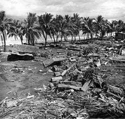
- The Mw 8.3 Celebes Sea earthquake occurred on August 15, 1918 with a maximum Mercalli intensity of X (Extreme). The offshore shock affected the southern Philippines with high intensity shaking and a destructive tsunami that left 52 people dead.
- A strong magnitude 8.0 earthquake struck Southern Mindanao on April 14, 1924.[19]
- A magnitude 7.8 Mw earthquake struck Panay Island on January 25, 1948 at 1:46 AM. The epicenter was between the municipalities of Anini-y and Dao (now Tobias Fornier) in Antique province.
- An intensity VII earthquake struck Luzon, mainly Isabela on December 29, 1949. Starting at 11:05 a.m., it lasted for two-and-a-half minutes. The damage was moderately destructive, causing landslides and rough waves capsizing boats, as well as fissures that spat out black water. The intensity ranged from IV to VII throughout Luzon.[20]
Mid to late 20th century
- A magnitude of 7.6 earthquake struck Casiguran, Aurora, on August 2, 1968, at the depth of approximately 31 km. It was considered the most severe and destructive earthquake experienced in the Philippines during the last 20 years. 270 people were reported dead and 261 were injured.
- A magnitude 7.0 quake struck Ragay Gulf on March 17, 1973. Calauag, Quezon was the worst hit, as the quake caused 98 houses totally destroyed, and 270 more were partially damaged.[21]
- A magnitude 8.0 earthquake struck Mindanao on August 16, 1976. The quake caused a devastating tsunami that had hit the 700 km coastline of the island of Mindanao bordering Moro Gulf in the North Celebes Sea. An estimated 5,000 – 8,000 people died. The major cause of the great number of casualties during the event could be attributed to the fact that the quake happened just after midnight when most people were sleeping; and a great tsunami was spawned, struck the coasts from different directions and caught the people unaware.[22]
- A magnitude 6.5 earthquake struck Laoag on August 17, 1983, at a depth of 42 km. The quake has caused the deaths of 16 and injured 47 people.[23]
- A magnitude 6.8 earthquake struck Bohol on February 8, 1990. Six fatalities were reported and more than 200 were injured in the event. About 46,000 people were displaced by the event and at least 7,000 among them were rendered homeless. Estimated damage to properties is amounting to ₱154-million.[24]
- A magnitude 7.1 earthquake struck Panay Island on June 14, 1990 at a depth of 15 km. Seven people died and 31 others were injured.[25]
- A magnitude 7.7 earthquake struck Luzon on July 16, 1990. It caused severe damage to major cities in Luzon: Dagupan City (soil liquefaction), Baguio City, and Cabanatuan City; Hyatt Terraces Baguio collapsed. 1,621 were reported dead. Damage to buildings, infrastructures, and properties amounted to at least ₱10-billion, a part of which was caused by ground rupturing. However, some houses within 1–2 m on either side of the ground rupture survived owing to their light-weight construction while those built of reinforced concrete within this zone suffered partial damage. Damage beyond 2m depended mainly on the structural integrity of the building and effects of local topography and ground conditions.[22][26]
- A magnitude 7.1 earthquake struck Mindoro on November 15, 1994 at depth of 15 km. The quake caused a tsunami killed 41 people and destroyed 1530 houses.[27]
- A series of large earthquakes struck Samar on April 21, 1995, with four of the largest earthquakes being near magnitude 7 and the largest one registering at magnitude 7.3. The earthquakes also resulted in a small tsunami that was recorded in Legazpi, Albay. The area was hit by another earthquake of magnitude 7.0 on May 5 of the same year.[28]
- A magnitude 5.6 earthquake struck Bohol on May 27, 1996 at a depth of 4 km. The earthquake did not cause major damage to properties. Damage was confined to poorly built structures and/or old wooden, masonry, limestone walls of houses and buildings, generally due to ground shaking.[29]
- A magnitude of 5.1 struck Bayugan, Agusan del Sur on June 7 and 9, 1999. The towns of Bayugan and Talacogon were the most devastated.[18]
- A magnitude 6.8 earthquake struck northwest of the coast of Zambales on December 12, 1999. The earthquake killed six people and injured 40 in Zambales, Pangasinan, and Metro Manila. The quake also caused power outages throughout Manila.[30]
21st century
Largest earthquakes by year

The largest or most notable Philippine earthquakes per year since 2001. As for the repeated entries, Moro Gulf near the Cotabato Trench is a seismically active area (the location of the devastating 1918 Celebes Sea earthquake and 1976 Moro Gulf earthquake). Meanwhile, Samar and Davao Region are near the northern and southern portions of the Philippine Trench, respectively.
| Year | Magnitude | Location / Name | Date |
|---|---|---|---|
| 2001 | 7.5 | Davao Region[31] | January 1 |
| 2002 | Moro Gulf (near) | March 5 | |
| 2003 | 6.5 | Samar | November 18 |
| 2004 | Mindoro | October 8 | |
| 2005 | 6.4 | Moro Gulf (near)[32] | November 30 |
| 2006 | 6.3 | Luzon (Luzon Strait) | October 9 |
| 2007 | 6.4 | Davao Region (near Davao Oriental)[33] | August 20 |
| 2008 | 6.9 | Samar | March 3 |
| 2009 | 6.6 | Moro Gulf | October 4 |
| 2010 | 7.6 | Moro Gulf | July 23 |
| 2011 | 6.4 | Ilocos Region | March 20 |
| 2012 | 6.9 [34] | Negros Oriental & Cebu | February 6 |
| 2012 | 7.6 | Samar | August 31 |
| 2013 | 7.2 | Bohol & Cebu | October 15 |
| 2014 | 6.6 | Moro Gulf (near)[35] | December 2 |
| 2015 | 6.1 | Siargao[36] | July 3 |
| 2016 | 6.3 | Davao Region (near Tamisan)[37] | September 24 |
| 2017 | 6.9 | Davao and Sarangani[38] | April 29 |
| 2018 | 7.1 | Davao Region (near Davao Oriental) | December 29 |
| 2019 | 6.9 | Matanao, Davao del Sur | December 15 |
| 2020 | 6.0 | Davao Region | February 6 |
All large known earthquakes
As the Philippines is subject to most seismic activity, to keep this list manageable, only strong earthquakes after 2001 are prioritized (those with M < 6 are discouraged), unless the event has other noteworthy qualities such as causing fatalities, significant damage, or other notable consequences.
- A magnitude of 7.5 quake struck Mindanao on January 1, 2001 at a depth of 33 km.[39]
- A magnitude of 7.5 quake struck Southern and Central Mindanao on March 5, 2002 at a depth of 31 km.[40] At least 15 people were killed, 100 injured and 800 buildings were damaged or destroyed.[41]
- A magnitude of 6.1 quake struck Sultan Kudarat on March 6, 2002. Office of Civil Defense (OCD) records show that 8 people had died and 41 were injured due to the earthquake. It affected 7,684 families in the provinces of Sultan Kudarat, Sarangani, North Cotabato and South Cotabato including four cities and 17 municipalities.[42]
- A magnitude of 6.2 quake struck Masbate on February 15, 2003 at a depth of 22 km. The quake damaged major infrastructures in Masbate.[43]
- A magnitude of 6.5 quake struck Samar on November 18, 2003. One person was reported dead.
- A magnitude of 6.5 quake struck Mindoro on October 8, 2004.
- A magnitude of 6.6 quake struck Moro Gulf on October 4, 2009.
- A series of quakes with the main quake's magnitude of 7.3 struck Moro Gulf on July 23–24, 2010.
- A magnitude of 6.4 quake struck Ilocos Region on March 20, 2011.
- A magnitude of 5.2 quake struck Valencia City, Bukidnon on November 8, 2011 at a depth of 1 km.[44] 39 people were injured, and several establishments were damaged.[45]
- A magnitude of 6.9 quake struck Negros, the rest of Central Visayas, and some parts of Mindanao on February 6, 2012, at a depth of 20 km. The quake killed people, caused major damage on infrastructures, and buildings. A tsunami alert level 2 was raised due to the quake. The quake also caused a landslide, burying a barangay. More than a thousand of aftershocks were recorded by PHIVOLCS within 2 days since the quake occurred.[46][47][48] According to National Disaster Risk Reduction and Management Council, as of February 18, 2012, the death toll have risen to 51 with 62 people still missing, and injuring 112 people. Most deaths came from the city of Guihulngan and La Libertad where landslides occurred. 63, 697 from provinces in Region VII were affected by the quake. 15, 483 houses were partially or totally damaged, and a total of ₱383-million worth of damage to buildings, roads and bridges, and other infrastructures were recorded.
- A magnitude of 5.9 quake struck Surigao City on March 16, 2012. Many were injured in the city for that certain day was the grand opening of Gaisano Capital Surigao. An estimated 6,000 people were in Gaisano when the earthquake happened. The earthquake caused a stampede which injured people.[49][50][51]
- A magnitude of 7.6 quake struck 106 km near Guiuan, Eastern Samar on August 31, 2012. It was also felt in certain areas of Visayas and Mindanao. One person died, and another one was injured in Cagayan de Oro City after being trapped in a collapsed house due to a landslide.[52] Minutes after the quake, power interruptions occurred in the affected areas. The National Disaster Risk Reduction and Management Council reported that a house in Agusan del Sur province caught fire sparked by a gas lamp that was toppled during the earthquake. It also reported that two bridges in Eastern Samar, particularly the Buyayawan Bridge in Mercedes town and the Barangay Casuroy Bridge in San Julian town, were partially damaged. The Abreeza Mall in Bajada, Davao City suffered minor cracks on the floor due to the earthquake.[53] In General MacArthur, Eastern Samar, 77 homes were damaged. There were also 6 houses damaged in Barangay Casoroy, San Julian.[54] In Balangiga, Eastern Samar, a hospital sustained serious damage.[55] A wall from an old building collapsed in Butuan City.[56] The NDRRMC reported on Saturday noon there were cracks on some roads and bridges and other establishments in areas where the quake was felt.[57] Most of the homes destroyed were those made of light materials, while overall damage to infrastructure remained minimal.[58] A tsunami warning of Level 3 was raised by the Philippine Institute of Volcanology and Seismology, but was lifted 5 hours after the quake only caused tiny waves.[59]
- A series of earthquakes, struck cities of Malaybalay and Valencia, and the sitio of Musuan, Maramag in Bukidnon last September 3–4, 2012. The first quake has a magnitude of 3.4 and was felt at 06:48 PM,[60] and was followed by magnitude 4.0 at 07:45 PM,[61] and 4.7 at 09:21 PM.[62] Hours after the first three, a series of quakes occurred in 03:44 AM and in 03:52 AM. The first quake had a magnitude of 5.6 with a depth of focus of 3 km;[63] while the second one was recorded at a magnitude of 4.9 with a depth focus of 3 km.[64] The quake was felt as far as Cagayan de Oro, Kidapawan, Butuan, and Cotabato cities.[65][66] A nun was injured in Barangay Lourdes in Valencia City after the incident. Valencia City Disaster Risk Reduction and Management Council reported that 144 houses and structures were destroyed. Mayor Ignacio Zubiri of Malaybalay City reported no casualties nor damage in his city.[67] The quakes were of tectonic in origin. A total of 131 aftershocks were recorded after the 5.6 quake in September 4, 2012.[68]
- A 6.2 earthquake struck off the coast of Southern Mindanao on February 16, 2013, 28 kilometers southeast of Caburan, Davao del Sur. According to the United States Geological Survey, the quake struck at a depth of 98.2 km.[69][70]
- A 5.7 earthquake struck the island of Mindanao on June 1, 2013.[71] The quake's epicenter was located in Carmen, Cotabato and struck with a depth of 5 kilometers.[72][73] The said quake injured six people, 4 of them were children, and fully or partly destroyed several houses, and some school buildings.[74][75] It also damaged a bridge at Barangay Kimadzil, and another one at Barangay Kibudtungan.[76] The quake was followed by 15 aftershocks, the last one was followed by a 4.3 quake on June 2, 2013.[77] The quake caused ₱71-million worth of damage. Another quake jolted the said town after 4:00 AM on June 3, 2013. The quake was recorded at 5.7 and struck at a depth of 3 kilometers.[78] The newest quake further injured 8 more people, and damaged more houses. Classes which was slated to open on June 3, 2013, were cancelled due to a series of quakes that hit the town since June 1, 2013.[79]
- A magnitude of 7.2 earthquake struck Bohol on October 15, 2013 at 8:12 a.m. (PST).[80] Its epicenter was located 6 kilometres (3.7 mi) SW of Sagbayan at a depth of 12 kilometres (7.5 mi). According to the official report by the National Disaster Risk Reduction and Management Council, 222 were reported dead while 796 people were injured. Tens of thousands of structures were damaged by the earthquake. Most notable were the national historical churches in Bohol and Cebu.
- Loon Church before and after the Bohol earthquake of October 15, 2013
 Loon Church prior to the earthquake
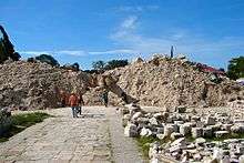 The rubble that was Loon Church after the quake
- A magnitude 6.1 quake struck 47 km N 47°E of Burgos (Surigao del Norte) on July 3, 2015, 2:43 pm at a depth of 26 km.[81]
- A magnitude 6.5 earthquake struck 10 km SW of Basilisa, Dinagat Islands on February 10, 2017, 10:03 pm at a depth of 15 km. Eight people were killed and 202 injured.[82]
- Batangas experienced an earthquake swarm in April 2017. A magnitude 5.5 earthquake struck 5 km W of Batangas on April 4, 2017, 8:58 pm at a depth of 82 km. Twin earthquakes with magnitudes of 5.6 and 6.0 hit the barangays of Bagalangit and Tanauan, both in Mabini, Batangas respectively on April 8, 2017, 3:07 and 3:09 pm at a depth of 40.4 km. Damages on some buildings and houses have been reported. Several aftershocks followed.
- A magnitude 6.9 earthquake struck 47 km S 26° W of Sarangani and Davao Occidental provinces on April 29, 2017 at 4:23 am at a depth of 57 km. Five people were injured.[83]
- A magnitude 6.5 earthquake struck 3 km S 16° E of Jaro, Leyte on July 6, 2017 at 4:03 pm at a depth of 8 km. It caused island-wide blackouts in the provinces of Samar, Bohol, Leyte, and parts of Southern Leyte In Kananga, a commercial building collapsed killing two persons and injuring 20 others. In Ormoc City, a landslide was triggered. Four people died and 100 others were injured.[84]
- A magnitude 7.1 earthquake struck off northeast of Governor Generoso, Davao Oriental on December 29, 2018 at 11:39 am at a depth of 49 km.[85] Tsunami warnings were raised at Tsunami Level 1 and waves were expected to be less than one meter.[86]
- A magnitude 6.1 earthquake struck Central Luzon (with epicenter in Castillejos, Zambales) on April 22, 2019 at 5:11 pm.[87] Widespread damage was also caused in Pampanga province,18 people were killed and 282 others injured.[88]
- A magnitude 6.4 earthquake struck Eastern Visayas (Eastern Samar) on April 23, 2019 at 1:37 pm.[89] 48 people were injured, most of them slightly by falling objects.[90]
- A twin magnitude 5.4 and 5.9 earthquake struck off east of Itbayat, Batanes on July 27, 2019.[91][92] The first tremor occurred at 4:16 am at a depth of 12 km and the second tremor occurred at 7:37 am at a depth of 21 km. The twin quakes destroyed several structures in Itbayat.[93] 9 people were confirmed dead while 60 people are injured.[94]
- A magnitude of 6.3 earthquake struck Tulunan, Cotabato on October 16, 2019 around 7:37 pm. [95] Seven people were reported dead and more than 200 others injured. Most of the houses in Brgy. Malawanit Magsaysay, Davao del Sur, were destroyed. The aftermath left frequent aftershocks extended to over a week on random cycles.[96]
- A magnitude of 6.6 earthquake again struck in Tulunan, Cotabato on October 29, 2019, with some reports stating that this earthquake felt much devastating as the previous earthquake that took place in October 16, 2019. [97] Nearby towns such as those in Kidapawan, North Cotabato and Davao city were also affected.
- A magnitude 6.5 earthquake struck Tulunan, Cotabato for the third time on October 31, 2019, Death toll amongst towns and cities nearby has increased; CNN Philippines reporting increased fatal casualties risen to 10 during live news broadcast. Revised body count reports 24 fatal casualties in total including the numbers from the two consecutive earthquakes that took place in October 29 and 31, with more than 500 people being injured and three reported missing.[98]
- A magnitude 5.9 earthquake struck in Kibawe, Bukidnon on November 18, 2019. Phivolcs said that the earthquake happened 9:22 pm, with the epicenter located in Kadingilan, Bukidnon. The earthquake, which was tectonic in origin, had a depth of 10 kilometers and was felt in the following areas.[99]
- A magnitude 6.8 earthquake struck Matanao, Davao del Sur on December 15, 2019 at 2:11 pm. 13 people were killed, one remains missing and 210 others were injured during this tremor.[100]
Deadliest earthquakes
The table below is a tally of the ten deadliest recorded earthquakes in the Philippines since the 1600s:
| Ten deadliest recorded earthquakes in the Philippines since the 1600s | ||||||||||
|---|---|---|---|---|---|---|---|---|---|---|
| Mag. | Origin | Location | Date | Mortality | Missing | Injured | Damage | Source | ||
| 1 | 8.0 | Tectonic | Moro Gulf | August 16, 1976 | 4,791 | 2,288 | 9,928 | |||
| 2 | 7.8 | Tectonic | Luzon Island | July 16, 1990 | 1,621 | 1,000 | 3,000 < | ₱ 10 billion | ||
| 3 | 7.5 | Tectonic | Luzon Island | November 30, 1645 | 600 < | 3,000 < | Unknown | |||
| 4 | 7.6 | Tectonic | Mindanao | March 31, 1955 | 400 < | Unknown | US$5 million | [101] | ||
| 5 | 7.6 | Tectonic | Casiguran, Aurora | August 2, 1968 | 271 | 261 | ||||
| 6 | 7.2 | Tectonic | Bohol and Cebu | October 15, 2013 | 222 | 8 | 796 | ₱ 4 billion (est.) | [102] | |
| 7 | 7.1 | Tectonic | Mindoro | November 15, 1994 | 78 | 430 | ₱ 5.15 million | [27] | ||
| 8 | 6.7 | Tectonic | Negros Oriental | February 6, 2012 | 51 | 62 | 112 | ₱ 383 million | ||
| 9 | 7.8 | Tectonic | Panay (Lady Caycay) | January 25, 1948 | 50 (est.) | ₱ 7 million | ||||
| 10 | 5.5 | Tectonic | Manila | June 19, 1665 | 19 | Unknown | ||||
See also
- Geology of the Philippines
References
- Districts nearby Mayon Volcano and Camalig, not the present-day Camarines provinces.
- Blair, Emma Helen and Robertson, James Alexander (1906). "The Philippine Islands 1493–1898 Vol. XXXV", pg. 17. Arthur H. Clark Co., Cleveland.
- Bautista, Maria Leonila P. & Bautista, Bartolome C. "Philippine Historical Earthquakes and Lessons Learned" (PDF). EqTAP Project. Archived from the original (PDF) on November 13, 2013. Retrieved February 7, 2012.
- Maso, Saderra (1902). Seismic and Volcanic Centers of the Philippine Archipelago. Manila: Bureau of Printing. p. 16.
- "M 6.7 – Luzon, Philippines". United States Geological Survey. Retrieved March 15, 2018.
- "M 7.5 – Philippine Islands region". United States Geological Survey. Retrieved March 15, 2018.
- "M 6.4 – Philippine Islands region". United States Geological Survey. Retrieved March 15, 2018.
- "M 6.7 – Philippine Islands region". United States Geological Survey. Retrieved March 15, 2018.
- "M 7.3 – Luzon, Philippines". United States Geological Survey. Retrieved April 22, 2019.
- "M 7.4 – Mindoro, Philippines". United States Geological Survey. Retrieved March 15, 2018.
- "M 7.5 – Mindoro, Philippines". United States Geological Survey. Retrieved March 15, 2018.
- "M 7.8 – Mindanao, Philippines". United States Geological Survey. 1913.
- "M 8.3 – Mindanao, Philippines". United States Geological Survey. 1918.
- "M 8.0 – Mindanao, Philippines". United States Geological Survey. 1924.
- "M 7.8 – Mindanao, Philippines". United States Geological Survey. 1943.
- "M 8.0 – Mindanao, Philippines". United States Geological Survey. 1972.
- "M 7.9 – Mindanao, Philippines". United States Geological Survey. 1976.
- "June 1999 Earthquakes in Agusan del Sur, Philippines". Philippine Institute of Volcanology and Seismology. Retrieved February 7, 2012.
- "M 8.0 – Mindanao, Philippines". USGS. Retrieved August 26, 2018.
- "Luzon Island Shaken By Major Earthquake". Evening Independent. December 29, 1949. Retrieved March 15, 2012.
- "Ragay Gulf Earthquake – 17 March 1973". Philippine Institute of Volcanology and Seismology. Retrieved February 7, 2012.
- "Historic World Earthquakes – Philippines". United States Geological Survey. Archived from the original on July 28, 2010. Retrieved February 7, 2012.
- "Laoag Earthquake – 17 August 1983". Philippine Institute of Volcanology and Seismology. Retrieved February 7, 2012.
- "Bohol Earthquake – February 8, 1990". Philippine Institute of Volcanology and Seismology. Retrieved February 7, 2012.
- "Panay Earthquake – 14 June 1990". Philippine Institute of Volcanology and Seismology. Retrieved February 7, 2012.
- Punongbayan, Raymundo S. et al. (Philippine Institute of Volcanology and Seismology); and Takashi Nakata, Hiroyuki Tsutsumi (Hiroshima University, Japan). "The 16 July 1990 Luzon Earthquake Ground Rupture". Philippine Institute of Volcanology and Seismology. Retrieved February 7, 2012.CS1 maint: multiple names: authors list (link)
- "1994 Mindoro Tsunami". Philippine Institute of Volcanology and Seismology. Retrieved February 7, 2012.
- "Samar Island, Philippines Earthquakes and Tsunami of April 21, 1995" (PDF). Tsunami Newsletter. Honolulu, Hawaii: International Tsunami Information Center. July 1995. Retrieved August 26, 2018.
- "Bohol Earthquake – 27 May 1996". Philippine Institute of Volcanology and Seismology. Retrieved February 7, 2012.
- "Philippines – Earthquake OCHA Situation Report No. 2". reliefweb. Retrieved August 31, 2018.
- "M 7.5 – Mindanao, Philippines". United States Geological Survey. Retrieved March 8, 2018.
- "M 6.4 – Mindanao, Philippines". United States Geological Survey. Retrieved March 8, 2018.
- "M 6.4 – Philippine Islands region". United States Geological Survey. Retrieved March 8, 2018.
- "Quake kills 52 in Negros Oriental | Inquirer News".
- "M 6.6 – 106km WSW of Sangay, Philippines". United States Geological Survey. Retrieved December 2, 2014.
- "M 6.1 – 23km NW of Santa Monica, Philippines". United States Geological Survey. Retrieved July 4, 2015.
- "M 6.3 – 36km SE of Tamisan, Davao Region, Philippines". United States Geological Survey. Retrieved November 15, 2016.
- "M 6.9 – 31km SW of Burias, Philippines". United States Geological Survey. Retrieved January 4, 2019.
- "Philippines: Mindanao Earthquake, 2001". National Geophysical Data Center. Retrieved February 7, 2012.
- "Magnitude 7 and Greater Earthquakes in 2002". United States Geological Survey. Archived from the original on February 18, 2012. Retrieved February 7, 2012.
- "Poster of the Mindanao, Philippines Earthquake of 05 March 2002 – Magnitude 7.5". United States Geological Survey. Retrieved February 7, 2012.
- "Palimbang Earthquake: Summary Report". Philippine Institute of Volcanology and Seismology. Retrieved February 7, 2012.
- "Masbate Earthquake: Report of Investigation". Philippine Institute of Volcanology and Seismology. Retrieved February 7, 2012.
- "Earthquake Information No. 5". Philippine Institute of Volcanology and Seismology. Retrieved February 7, 2012.
- "39 hurt in Bukidnon quake". ABS-CBN News. November 8, 2011. Retrieved February 6, 2012.
- Abigail Kwok; Joseph Ubalde & Lira Dalangin-Fernandez (February 6, 2012). "Number of casualties rises as 6.9 quake strikes off Negros". Interaksyon. Archived from the original on February 9, 2012. Retrieved February 7, 2012.
- Ellalyn B. De Vera; Elena L. Aben & Mars W. Mosqueda Jr. (February 6, 2012). "Quake Jolts Visayas". Manila Bulletin. Retrieved February 6, 2012.
- "Strong quake jolts Negros-Cebu; fatalities rising". ABS-CBN News. February 6, 2012. Retrieved February 6, 2012.
- "5.9-magnitude quake sparks stampede in Surigao". Sun.Star. March 16, 2012. Retrieved September 4, 2012.
- "Phivolcs: Magnitude-5.9 quake hits Surigao area, damage and aftershocks expected". GMA News Online. March 16, 2012. Retrieved September 4, 2012.
- "Quake leads to stampede at Surigao mall". Rappler. March 16, 2012. Retrieved September 4, 2012.
- Cerojano, Teresa (September 1, 2012). "Quake off Philippines spurs small tsunami; 1 dead". Associated Press. Retrieved September 4, 2012.
- "One dead as 7.6-magnitude quake hits Philippines". The Philippine Star. September 1, 2012. Retrieved September 4, 2012.
- "Quake damages 77 homes in E. Samar town". ABS-CBN News. September 1, 2012. Retrieved September 4, 2012.
- "Quake severely damages E. Samar hospital". ABS-CBN News. September 4, 2012. Retrieved September 4, 2012.
- "Quake causes panic, damage in Visayas, Mindanao". ABS-CBN News. September 1, 2012. Retrieved September 4, 2012.
- "Strong quake, but minimal effects: gov't". The Philippine Star. Xinhua. September 2, 2012. Retrieved September 4, 2012.
- "Philippine families rebuild amid further quake fears". Business Recorder. Agence France-Presse. September 2, 2012. Retrieved September 4, 2012.
- "At least 1 dead in 7.6 Philippine quake, small tsunami reported, warning canceled". Fox News. Associated Press. August 31, 2012. Retrieved September 4, 2012.
- "Earthquake Information: September 3, 2012 06:48:49 PM". Philippine Institute of Volcanology and Seismology. Retrieved February 7, 2012.
- "Earthquake Information: September 3, 2012 07:45:48 PM". Philippine Institute of Volcanology and Seismology. Retrieved February 7, 2012.
- "Earthquake Information: September 3, 2012 09:21:04 PM". Philippine Institute of Volcanology and Seismology. Retrieved February 7, 2012.
- "Earthquake Information: September 4, 2012 03:44:22 AM". Philippine Institute of Volcanology and Seismology. Retrieved February 7, 2012.
- "Earthquake Information: September 4, 2012 03:52:26 AM". Philippine Institute of Volcanology and Seismology. Retrieved February 7, 2012.
- "5.6 quake jolts Bukidnon, nearby provinces". The Philippine Star. September 4, 2012. Retrieved September 4, 2012.
- Mangosing, Frances (September 4, 2012). "5.6-magnitude quake shakes Bukidnon". Philippine Daily Inquirer. Retrieved September 4, 2012.
- "Nun injured; 144 structures, houses destroyed in Bukidnon quakes". Bukidnon News. September 4, 2012. Retrieved September 4, 2012.
- "Initial Report re Effects of Earthquake in Maramag, Bukidnon" (PDF). National Disaster Risk Reduction and Management Council. February 18, 2012. p. 17. Archived from the original (PDF) on October 17, 2012. Retrieved February 19, 2012.
- "Magnitude 6.2 earthquake jolts Mindanao". The Philippine Star. February 16, 2013. Retrieved February 26, 2013.
- Stephanie Tong (February 16, 2013). "Magnitude-6 Quakes Hit Offshore in Philippines, New Zealand". Bloomberg. Retrieved February 26, 2013.
- "Strong quake jolts Cotabato". Sun Star Davao. June 1, 2013. Retrieved June 3, 2013.
- Frances Mangosing (June 1, 2013). "5.7-quake shakes Mindanao—Phivolcs". Philippine Daily Inquirer. Retrieved June 3, 2013.
- "Magnitude 5.7 quake felt in several Mindanao areas". Minda News. June 2, 2013. Retrieved June 3, 2013.
- Jasper Acosta (June 2, 2013). "Quake destroys 30 houses in Carmen, N. Cotabato". ABS-CBN News. Retrieved June 2, 2013.
- Keith Bacongco (June 2, 2013). "5 injured in Saturday's magnitude 5.7 quake; 30 houses partly destroyed". Minda News. Retrieved June 3, 2013.
- Edwin Fernandez (June 3, 2013). "Classes in quake-hit North Cotabato town suspended". Philippine Daily Inquirer. Retrieved June 3, 2013.
- Alexander D. Lopez (June 2, 2013). "Magnitude 5.7 quake hits North Cotabato". Manila Bulletin. Retrieved June 3, 2013.
- John Unson (June 3, 2013). "P71M worth of properties damaged in Cotabato quake". The Philippine Star. Retrieved June 3, 2013.
- Malu Cadelina Manar (June 3, 2013). "DepEd suspends classes in quake-affected town of Carmen". Manila Bulletin. Retrieved June 3, 2013.
- Frances Mangosing (October 15, 2013). "Death toll from Bohol quake jumps to 85". Philippine Daily Inquirer. Retrieved October 15, 2013.
- "003 km N 59° e of Kananga (Leyte) Information No. 2".
- "Aftershocks rattle survivors after Philippine quake kills 8". Fox News. February 12, 2017. Retrieved October 1, 2017.
- "Update on Sitrep No.02 re Magnitude 7.2 Earthquake in Sarangani, Davao Occidental, Issued on 30 April 2017" (PDF). National Disaster Risk Reduction and Management Council. April 30, 2017. Retrieved December 16, 2019.
- Correspondent, Barbara Mae Dacanay (July 8, 2017). "Four dead, 100 injured in Leyte's 6.5 magnitude quake". GulfNews. Retrieved October 1, 2017.
- "Magnitude 7.1 quake strikes off Davao Oriental". Rappler. December 29, 2018.
- "Tsunami warning issued after 7.2 magnitude earthquake hits Davao Oriental". Local Pulse. December 29, 2018.
- "Magnitude 6.1 earthquake rocks Luzon". Rappler. April 22, 2019.
- "18 dead, over 280 injured in Central Luzon due to quake — NDRRMC". GMA News Online. Retrieved April 25, 2019.
- "M 6.4 – 17km ESE of Tutubigan, Philippines". earthquake.usgs.gov. Retrieved April 23, 2019.
- National Disaster Risk Reduction and Management Council (April 30, 2019). "NDRRMC Update:SitRep No.09 re Magnitude 6.5 Earthquake in San Julian, Eastern Samar" (PDF). Retrieved December 16, 2019.
- "Magnitude 5.4 earthquake hits Itbayat, Batanes". GMA News. July 27, 2019.
- "Magnitude 5.9 quake rocks Batanes". ABS-CBN News. July 27, 2019.
- "LOOK: Itbayat church, ancestral homes damaged in Batanes earthquake". Rappler. July 27, 2019.
- Cataluña, Juliet. "Some Batanes quake fatalities buried immediately". newsinfo.inquirer.net. Retrieved July 27, 2019.
- Armand Vervaeck (October 16, 2019). "Very dangerous earthquake in Mindanao, Philippines – October 16, 2019". Earthquake-Report.com. Retrieved October 30, 2019.
- National Disaster Risk Reduction and Management Council (October 21, 2019). "NDRRMC Update: Situational Report No,09 regarding Magnitude 6.3 in Tulunan, NOrth Cotabato" (PDF). Retrieved December 16, 2019.
- News, ABS-CBN. "Phivolcs: October 16 quake a foreshock to October 29 tremor". ABS-CBN News. Retrieved October 30, 2019.
- "NDRRMC Update: SitRep No.23 regarding Magnitude 6.6 and 6.5 Earthquakes in Tulunan, North Cotabato" (PDF). November 13, 2019. Retrieved December 16, 2019.
- "(2nd update) Magnitude 5.9 quake jolts Bukidnon". Minda News. November 18, 2019. Retrieved December 16, 2019.
- National Disaster Risk Reduction and Management Council (December 22, 2019). "NDRRMC Update: SitRep No. 12 regarding Magnitude 6.9 Earthquake in Matanao, Davao del Sur (Region XI)" (PDF). Retrieved December 22, 2019.
- NCEI. "Global Significant Earthquake Database, 2150 B.C. to present". NOAA National Centers for Environmental Information.
- "Massive extremely dangerous earthquake in Bohol, Philippines – At least 222 people killed, 8 missing, over 790 injured, around 4 billion PHP damage, 7 billion PHP reconstruction costs". Earthquake-Report.com. November 14, 2013. Retrieved December 16, 2019.
External links
| Wikimedia Commons has media related to Earthquakes in the Philippines. |
- Official website of the Philippine Institute of Volcanology and Seismology
- Latest Earthquake Bulletin in the Philippines
- Official website of the National Disaster Risk Reduction and Management Council
List of earthquakes in Asia | |
|---|---|
| Sovereign states |
|
| States with limited recognition |
|
| Dependencies and other territories |
|
| |