Panay, Capiz
Panay, officially the Municipality of Panay, is a 3rd class municipality in the province of Capiz, Philippines. According to the 2015 census, it has a population of 46,114 people.[3]
Panay | |
|---|---|
| Municipality of Panay | |
 | |
| Motto(s): Heritage Capital of Capiz | |
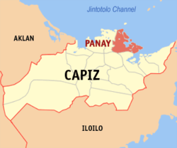 Map of Capiz with Panay highlighted | |

| |
.svg.png) Panay Location within the Philippines | |
| Coordinates: 11°33′N 122°48′E | |
| Country | |
| Region | Western Visayas (Region VI) |
| Province | Capiz |
| District | 1st district of Capiz |
| Founded | 1566 |
| Barangays | 42 (see Barangays) |
| Government | |
| • Type | Sangguniang Bayan |
| • Mayor | Felipe B. Barredo |
| • Vice Mayor | Arminda A. Bermejo |
| • Congressman | Emmanuel A. Billones |
| • Electorate | 32,933 voters (2019) |
| Area | |
| • Total | 116.37 km2 (44.93 sq mi) |
| Elevation | 7.7 m (25.3 ft) |
| Population (2015 census)[3] | |
| • Total | 46,114 |
| • Density | 400/km2 (1,000/sq mi) |
| • Households | 10,938 |
| Economy | |
| • Income class | 3rd municipal income class |
| • Poverty incidence | 19.29% (2015)[4] |
| • Revenue (₱) | 104,321,910.21 (2016) |
| Time zone | UTC+8 (PST) |
| ZIP code | 5801 |
| PSGC | |
| IDD : area code | +63 (0)36 |
| Climate type | tropical climate |
| Native languages | Capiznon Hiligaynon Tagalog |
Pronounced as Pan-ay, it used to be the Capital of Capiz Province. Panay is 8 kilometres (5.0 mi) east from Roxas City.
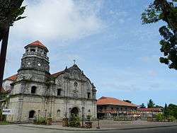
Pan-ay is the site of the famous coral-stone Santa Monica Church, home to the largest Catholic Church bell in Asia.
History
The town originally called Bamban was changed by the early Spaniards to Panay, a word which means “mouth of the river.” This is also the location of a fortress built by Juan de la Isla in late 1570. The Paseo de Evangelizacion 1566 can be found in the town plaza and was erected through the efforts of Rev. Msgr. Benjamin F. Advincula. 1566 was the year the Spaniards arrived in the island of Panay and became the second Spanish settlement in the country next to Cebu.
Miguel Lopez de Legazpi transferred the Spanish settlement from Cebu to Panay in 1569 due to the lack of food. The town was formally founded in 1572 (1581 according to Jorde), although by that time Legazpi had moved the capital of the Philippines, further north, to Manila. Fr. Bartolome de Alcantara was named the prior of the town with Fr. Agustin Camacho as assistant. A prosperous town due to trade, Pan-ay became capital of captivating Capiz for two centuries, until Capiz was named capital. The town name was eventually given to whole island. After 1607, Fr. Alonso de Méntrida, noted for his linguistic studies and Visayan dictionary became prior. In the 18th century, Pan-ay was famous for its textile industry which produced a cloth called suerte and exported to Europe. In the 19th century, Don Antonio Roxas, grandfather of Pres. Manuel Roxas, opened one of the largest rum and wine distilleries in the town. The Augustinians held the parish until 1898, when administration transferred to the seculars.
The first church was built before 1698 when it is reported that a typhoon had ruined it. In 1774, Fr. Miguel Murguía rebuilt the church, but it was later damaged by a typhoon on 15 January 1875. Fr. Jose Beloso restored the church in 1884. The church is best known for its 10.4 ton bell popularly called dakong lingganay (big bell). The bell was cast by Don Juan Reina who settled in Iloilo in 1868. Reina who was town dentist was also noted as a metal caster and smith. The bell was cast at Pan-ay from 70 sacks of coins donated by the townspeople. The bell was completed in 1878. It bears an inspiring inscription which translated reads: “I am God’s voice which shall echo praise from one end of the town of Pan-ay to the other, so that Christ’s faithful followers may enter this house of God to receive heavenly graces.”
Barangays
Panay is politically subdivided into 42 barangays. [2]
- Agbalo
- Agbanban
- Agojo
- Anhawon
- Bagacay
- Bago Chiquito
- Bago Grande
- Bahit
- Bantique
- Bato
- Binangig
- Binantuan
- Bonga
- Buntod
- Butacal
- Cabugao Este
- Cabugao Oeste
- Calapawan
- Calitan
- Candual
- Cogon
- Daga
- Ilamnay
- Jamul-awon
- Lanipga
- Lat-asan
- Libon
- Linao
- Linateran
- Lomboy
- Lus-onan
- Magubilan
- Navitas
- Pawa
- Pili
- Poblacion Ilawod
- Poblacion Ilaya
- Poblacion Tabuc
- Talasa
- Tanza Norte
- Tanza Sur
- Tico
Climate
| Climate data for Panay, Capiz | |||||||||||||
|---|---|---|---|---|---|---|---|---|---|---|---|---|---|
| Month | Jan | Feb | Mar | Apr | May | Jun | Jul | Aug | Sep | Oct | Nov | Dec | Year |
| Average high °C (°F) | 27 (81) |
28 (82) |
29 (84) |
31 (88) |
32 (90) |
31 (88) |
30 (86) |
30 (86) |
29 (84) |
29 (84) |
29 (84) |
27 (81) |
29 (85) |
| Average low °C (°F) | 23 (73) |
23 (73) |
23 (73) |
24 (75) |
25 (77) |
25 (77) |
24 (75) |
24 (75) |
24 (75) |
24 (75) |
24 (75) |
23 (73) |
24 (75) |
| Average precipitation mm (inches) | 61 (2.4) |
39 (1.5) |
46 (1.8) |
48 (1.9) |
90 (3.5) |
144 (5.7) |
152 (6.0) |
145 (5.7) |
163 (6.4) |
160 (6.3) |
120 (4.7) |
90 (3.5) |
1,258 (49.4) |
| Average rainy days | 12.3 | 9.0 | 9.9 | 10.0 | 18.5 | 25.0 | 27.4 | 26.0 | 25.9 | 24.9 | 17.9 | 14.2 | 221 |
| Source: Meteoblue [5] | |||||||||||||
Demographics
| Population census of Panay | ||
|---|---|---|
| Year | Pop. | ±% p.a. |
| 1903 | 14,361 | — |
| 1918 | 13,409 | −0.46% |
| 1939 | 15,800 | +0.78% |
| 1948 | 16,648 | +0.58% |
| 1960 | 19,952 | +1.52% |
| 1970 | 24,074 | +1.89% |
| 1975 | 27,479 | +2.69% |
| 1980 | 31,650 | +2.87% |
| 1990 | 36,817 | +1.52% |
| 1995 | 39,124 | +1.15% |
| 2000 | 40,599 | +0.80% |
| 2007 | 42,357 | +0.59% |
| 2010 | 43,449 | +0.93% |
| 2015 | 46,114 | +1.14% |
| Source: Philippine Statistics Authority[3][6][7][8] | ||
In the 2015 census, the population of Panay, Capiz, was 46,114 people,[3] with a density of 400 inhabitants per square kilometre or 1,000 inhabitants per square mile.
References
- "Municipality". Quezon City, Philippines: Department of the Interior and Local Government. Retrieved 31 May 2013.
- "Province: Capiz". PSGC Interactive. Quezon City, Philippines: Philippine Statistics Authority. Retrieved 12 November 2016.
- Census of Population (2015). "Region VI (Western Visayas)". Total Population by Province, City, Municipality and Barangay. PSA. Retrieved 20 June 2016.
- "PSA releases the 2015 Municipal and City Level Poverty Estimates". Quezon City, Philippines. Retrieved 12 October 2019.
- "Panay: Average Temperatures and Rainfall". Meteoblue. Retrieved 2 May 2020.
- Census of Population and Housing (2010). "Region VI (Western Visayas)". Total Population by Province, City, Municipality and Barangay. NSO. Retrieved 29 June 2016.
- Censuses of Population (1903–2007). "Region VI (Western Visayas)". Table 1. Population Enumerated in Various Censuses by Province/Highly Urbanized City: 1903 to 2007. NSO.
- "Province of Capiz". Municipality Population Data. Local Water Utilities Administration Research Division. Retrieved 17 December 2016.
External links
| Wikimedia Commons has media related to Panay, Capiz. |
- Panay Profile at PhilAtlas.com
- Official Website of Municipality of Panay
- Philippine Standard Geographic Code
- Philippine Census Information
- Panay LGU Official Site
Places adjacent to Panay, Capiz | ||||||||||
|---|---|---|---|---|---|---|---|---|---|---|
| ||||||||||