Tangalan
Tangalan, officially the Municipality of Tangalan, (Aklanon: Banwa it Tangalan; Hiligaynon: Banwa sang Tangalan; Tagalog: Bayan ng Tangalan), is a 5th class municipality in the province of Aklan, Philippines. According to the 2015 census, it has a population of 21,916 people.[4]
Tangalan | |
|---|---|
| Municipality of Tangalan | |
 Seal | |
 Map of Aklan with Tangalan highlighted | |
OpenStreetMap 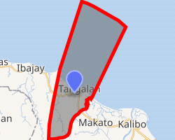
| |
.svg.png) Tangalan Location within the Philippines | |
| Coordinates: 11°46′N 122°15′E | |
| Country | |
| Region | Western Visayas (Region VI) |
| Province | Aklan |
| District | 2nd district of Aklan |
| Barangays | 15 (see Barangays) |
| Government | |
| • Type | Sangguniang Bayan |
| • Mayor | Gary T. Fuentes |
| • Vice Mayor | Gene T. Fuentes |
| • Congressman | Teodorico T. Haresco Jr. |
| • Electorate | 14,399 voters (2019) |
| Area | |
| • Total | 74.59 km2 (28.80 sq mi) |
| Elevation | 9.7 m (31.8 ft) |
| Population (2015 census)[4] | |
| • Total | 21,916 |
| • Density | 290/km2 (760/sq mi) |
| • Households | 4,920 |
| Economy | |
| • Income class | 5th municipal income class |
| • Poverty incidence | 23.46% (2015)[5] |
| • Revenue (₱) | 65,648,823.50 (2016) |
| Time zone | UTC+8 (PST) |
| ZIP code | 5612 |
| PSGC | |
| IDD : area code | +63 (0)36 |
| Climate type | tropical climate |
| Native languages | Aklan language Hiligaynon Tagalog |
| Website | www |
Tangalan was formerly an arrabal of Makato. At the time of its creation, it included the following barrios: Tondog, Jawili, Dumatad, Afga, Baybay, Dapdap, Pudyot, Tagas, Tamalagon, Panayakan, Vivo, Lanipga, Napatag and Tamokoe.[6]
Geography
Tangalan is located at 11°46′N 122°15′E. It is 18 kilometres (11 mi) from Kalibo, the provincial capital.
According to the Philippine Statistics Authority, the municipality has a land area of 74.59 square kilometres (28.80 sq mi) [2] constituting 4.10% of the 1,821.42-square-kilometre- (703.25 sq mi) total area of Aklan.
Climate
| Climate data for Tangalan, Aklan | |||||||||||||
|---|---|---|---|---|---|---|---|---|---|---|---|---|---|
| Month | Jan | Feb | Mar | Apr | May | Jun | Jul | Aug | Sep | Oct | Nov | Dec | Year |
| Average high °C (°F) | 28 (82) |
29 (84) |
30 (86) |
32 (90) |
32 (90) |
31 (88) |
30 (86) |
29 (84) |
29 (84) |
29 (84) |
29 (84) |
28 (82) |
30 (85) |
| Average low °C (°F) | 23 (73) |
23 (73) |
23 (73) |
24 (75) |
25 (77) |
25 (77) |
25 (77) |
24 (75) |
24 (75) |
24 (75) |
24 (75) |
23 (73) |
24 (75) |
| Average precipitation mm (inches) | 47 (1.9) |
33 (1.3) |
39 (1.5) |
48 (1.9) |
98 (3.9) |
150 (5.9) |
169 (6.7) |
147 (5.8) |
163 (6.4) |
172 (6.8) |
118 (4.6) |
80 (3.1) |
1,264 (49.8) |
| Average rainy days | 11.4 | 8.2 | 9.3 | 9.7 | 19.1 | 25.6 | 27.4 | 25.5 | 25.5 | 25.2 | 18.5 | 14.5 | 219.9 |
| Source: Meteoblue [7] | |||||||||||||
Barangays
Tangalan is politically subdivided into 15 barangays.[8]
| PSGC | Barangay | Population | ±% p.a. | |||
|---|---|---|---|---|---|---|
| 2015[4] | 2010[9] | |||||
| 060417001 | Afga | 7.4% | 1,612 | 1,472 | 1.74% | |
| 060417002 | Baybay | 7.3% | 1,597 | 1,582 | 0.18% | |
| 060417003 | Dapdap | 4.8% | 1,042 | 966 | 1.45% | |
| 060417004 | Dumatad | 5.2% | 1,130 | 1,051 | 1.39% | |
| 060417005 | Jawili | 8.3% | 1,822 | 1,732 | 0.97% | |
| 060417006 | Lanipga | 1.5% | 330 | 312 | 1.07% | |
| 060417007 | Napatag | 1.0% | 224 | 280 | −4.16% | |
| 060417008 | Panayakan | 14.2% | 3,116 | 2,684 | 2.88% | |
| 060417009 | Poblacion | 6.9% | 1,516 | 1,429 | 1.13% | |
| 060417010 | Pudiot | 8.3% | 1,828 | 1,617 | 2.36% | |
| 060417011 | Tagas | 11.0% | 2,407 | 2,017 | 3.42% | |
| 060417012 | Tamalagon | 11.9% | 2,609 | 2,497 | 0.84% | |
| 060417013 | Tamokoe | 0.7% | 154 | 228 | −7.20% | |
| 060417014 | Tondog | 8.9% | 1,955 | 1,745 | 2.19% | |
| 060417015 | Vivo | 2.6% | 574 | 665 | −2.76% | |
| Total | 21,916 | 20,277 | 1.49% | |||
Demographics
| Population census of Tangalan | ||
|---|---|---|
| Year | Pop. | ±% p.a. |
| 1903 | 3,009 | — |
| 1948 | 6,765 | +1.82% |
| 1960 | 7,650 | +1.03% |
| 1970 | 9,987 | +2.70% |
| 1975 | 10,509 | +1.03% |
| 1980 | 11,174 | +1.23% |
| 1990 | 14,773 | +2.83% |
| 1995 | 16,172 | +1.71% |
| 2000 | 17,606 | +1.84% |
| 2007 | 19,121 | +1.15% |
| 2010 | 20,277 | +2.16% |
| 2015 | 21,916 | +1.49% |
| Source: Philippine Statistics Authority[4][9][10][11] | ||
In the 2015 census, Tangalan had a population of 21,916.[4] The population density was 290 inhabitants per square kilometre (750/sq mi).
Attractions
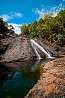
Tourist spots with government support under "Project Bugna" include Jawili Falls, Jawili Beach Resorts, Dumatad Souvenir Shop, and Bughawi Reforestation Project.
The Tangalan Marine Sanctuary covers 375 hectares (930 acres) of marine ecosystem and a 10 hectares (25 acres) coral garden.
References
- "Municipality". Quezon City, Philippines: Department of the Interior and Local Government. Retrieved 31 May 2013.
- "Province: Aklan". PSGC Interactive. Quezon City, Philippines: Philippine Statistics Authority. Retrieved 12 November 2016.
- "Tangalan, Aklan Profile". PhilAtlas.com. Retrieved 15 June 2020.
- Census of Population (2015). "Region VI (Western Visayas)". Total Population by Province, City, Municipality and Barangay. PSA. Retrieved 20 June 2016.
- "PSA releases the 2015 Municipal and City Level Poverty Estimates". Quezon City, Philippines. Retrieved 12 October 2019.
- "Republic Act No. 285; An Act Creating the Municipality of Tangalan in the Province of Capiz". The Corpus Juris. 16 June 1948. Retrieved 22 October 2016.
- "Tangalan: Average Temperatures and Rainfall". Meteoblue. Retrieved 1 May 2020.
- "Municipal: Tangalan". PSGC Interactive. Quezon City, Philippines: Philippine Statistics Authority. Retrieved 8 January 2016.
- Census of Population and Housing (2010). "Region VI (Western Visayas)". Total Population by Province, City, Municipality and Barangay. NSO. Retrieved 29 June 2016.
- Censuses of Population (1903–2007). "Region VI (Western Visayas)". Table 1. Population Enumerated in Various Censuses by Province/Highly Urbanized City: 1903 to 2007. NSO.
- "Province of Aklan". Municipality Population Data. Local Water Utilities Administration Research Division. Retrieved 17 December 2016.
External links
| Wikimedia Commons has media related to Tangalan, Aklan. |
- Official website
- Tangalan Profile at PhilAtlas.com
- Philippine Standard Geographic Code
- ABS-CBN Choose Philippines travelogue on Tangalan
Places adjacent to Tangalan | ||||||||||
|---|---|---|---|---|---|---|---|---|---|---|
| ||||||||||