Davao del Sur
Davao del Sur (Cebuano: Habagatang Dabaw) is a province in the Philippines located in the Davao Region in Mindanao. Its capital and largest city is Digos. The province is bounded by Davao del Norte to the north; Davao Occidental to the south-east; North Cotabato and Sultan Kudarat to the west; South Cotabato and Sarangani to the south-west ; and the Davao Gulf to the east.
Davao del Sur | |
|---|---|
| Province of Davao del Sur | |
 Flag  Seal | |
| Etymology: Davao del Sur (i.e., "Southern Davao") | |
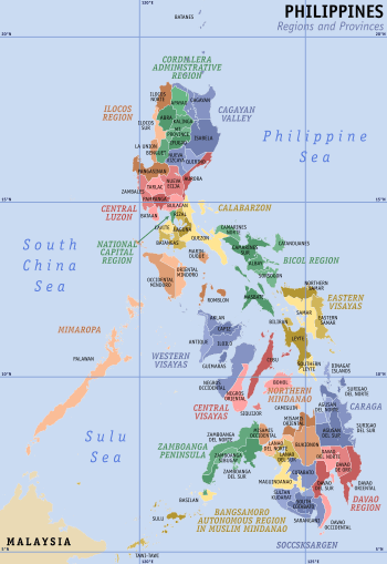
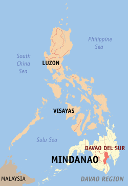 Location in the Philippines | |
| Coordinates: 6°20′N 125°30′E | |
| Country | Philippines |
| Region | Davao Region (Region XI) |
| Founded | May 8, 1967 |
| Capital | Digos |
| Government | |
| • Type | Sangguniang Panlalawigan |
| • Governor | Douglas R. Cagas |
| • Vice Governor | Marc Douglas C. Cagas IV |
| • Representative | Mercedes C. Cagas |
| Area | |
| • Total | 2,163.98 km2 (835.52 sq mi) |
| Area rank | 56th out of 81 |
| (excluding Davao City) | |
| Highest elevation | 2,954 m (9,692 ft) |
| Population (2015 census)[2] | |
| • Total | 632,588 |
| • Rank | 45th out of 81 |
| • Density | 290/km2 (760/sq mi) |
| • Density rank | 27th out of 81 |
| (excluding Davao City) | |
| Demonym(s) | Southern Davaoeño |
| Divisions | |
| • Independent cities | |
| • Component cities | 1
|
| • Municipalities | |
| • Barangays |
|
| • Districts | Lone District of Davao del Sur |
| Time zone | UTC+8 (PHT) |
| ZIP code | 8000–8010 |
| IDD : area code | +63 (0)82 |
| ISO 3166 code | PH |
| Spoken languages | |
| Income classification | 1st class |
| Website | davaodelsur |
History
The beginnings of both Davao Region and Davao del Sur were associated with the foundation of Davao, which was the first town to be founded in southern Mindanao in 1848, following the conquest of the area by José Uyanguren of the Basque province of Gipuzkoa, Spain (Guipúzcoa in Spanish). In 1849, Nueva Guipúzcoa province was founded in the region conquered by Uyanguren in what is now Davao Region, with Davao, then called Nueva Vergara, as the provincial capital. Uyanguren became the provincial governor, but he failed in his efforts to develop Nueva Guipúzcoa.
Thirty-six years after the foundation of Davao, the town of Santa Cruz was founded on the 5th day of October, 1884. It is the first town to be founded south of Davao and is now the oldest in the province.
The Spanish administration in the Philippines ended in 1898 following the defeat of the Spaniards during the Spanish–American War. In the early 1900s, waves of immigrants from the Visayas, Luzon, and as well as from Japan began to live in the region, centered mainly in Davao. The region began to boom in economic growth as agricultural business proliferated in the region.
As part of the "food bowl" of what is now the province of Davao del Sur, otherwise known as the Padada Valley, the agricultural area south of the town of Santa Cruz, which is known as Digos that time, lured many migrants, majority of whom came from the Visayas and Ilocos regions to settle permanently in the area. Before World War II, an enterprising American by the name of N.E. Crumb leased 10.24 square kilometres (3.95 sq mi) and transformed the place into an abaca plantation. This became the hub of economic activity in the locality during those days.
In 1942, during the start of the World War II in the Pacific, the first waves of invading Japanese units landed and entered the province of southern Davao.
In 1945, the liberation of southern Davao by United States and Philippine Commonwealth troops was supported by Davaoeño guerrilla fighters.
In 1967, Davao Province was divided into three provinces, one of them being Davao del Sur; the town of Digos was made its capital and would become a suburban city for the next 33 years.
On October 28, 2013, along with the Barangay Elections, a plebiscite was held to create a new province Davao Occidental, formed out of the southern part of Davao del Sur, covering the municipalities of the 2nd district of the province, namely Don Marcelino, Jose Abad Santos, Santa Maria, Sarangani and Malita (which was designated as the provincial capital) by virtue of Republic Act 10360 enacted on July 23, 2013, and the majority of votes cast were "Yes", ratifying the province.[3]
In 2015, the National Competitiveness Council, ranked the province as the most competitive province in the country.
Geography
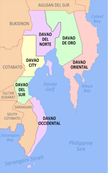
Davao del Sur covers a total area of 2,163.98 square kilometres (835.52 sq mi)[4] occupying the southwestern section of the Davao Region in Mindanao. When Davao City is included for geographical purposes, the province's land area is 4,607.59 square kilometres (1,779.00 sq mi).[4] The province is bounded by Davao del Norte to the north; Davao Occidental to the south-east; North Cotabato and Sultan Kudarat to the west; South Cotabato and Sarangani to the south-west ; and the Davao Gulf to the east.
The province is composed of sandy beaches and outlying islands, agricultural plains and valleys, rainforests, swamps, rolling hills and mountains, including the Philippines' highest peak, Mount Apo, which is at 2,954 metres (9,692 ft) above sea level.
Administrative divisions
Davao del Sur comprises 9 municipalities and 1 component city, all encompassed by a lone legislative district. Davao City, although part of the province for geographical and statistical purposes, is governed independently from the province.

|
| |||||||||||||||||||||||||||||||||||||||||||||||||||||||||||||||||||||||||||||||||||||||||||||||||||||||||||||||||||||||||||||||||||||||||||||||||||||||||||||||||||||||||||||
Climate
The province enjoys a mild, pleasant climate all year round. Because of its topographical characteristics and geographical location, it is rarely visited by typhoons. There is no pronounced wet or dry season. The coolest months are from November to February with an average temperature of 25 °C (77 °F). during the peak summer months from March to May, temperatures average 28 °C (82 °F) but may rise as high as 32 °C (90 °F).
| Climate data for Davao del Sur, Philippines | |||||||||||||
|---|---|---|---|---|---|---|---|---|---|---|---|---|---|
| Month | Jan | Feb | Mar | Apr | May | Jun | Jul | Aug | Sep | Oct | Nov | Dec | Year |
| Record high °C (°F) | 42 (108) |
38 (101) |
39 (102) |
38 (100) |
37 (99) |
43 (109) |
38 (101) |
39 (102) |
39 (103) |
38 (100) |
34 (93) |
38 (100) |
43 (109) |
| Average high °C (°F) | 30 (86) |
31 (87) |
31 (88) |
32 (90) |
32 (89) |
31 (87) |
31 (87) |
31 (88) |
31 (88) |
31 (88) |
31 (88) |
31 (87) |
31 (88) |
| Average low °C (°F) | 23 (74) |
23 (74) |
24 (75) |
24 (76) |
24 (76) |
24 (76) |
24 (75) |
24 (75) |
24 (75) |
24 (75) |
24 (75) |
24 (75) |
24 (75) |
| Record low °C (°F) | 19 (66) |
20 (68) |
20 (68) |
21 (70) |
22 (72) |
22 (72) |
22 (71) |
21 (70) |
21 (70) |
22 (71) |
22 (72) |
21 (69) |
19 (66) |
| Source: Weatherbase[6] | |||||||||||||
Demographics
| Population census of Davao del Sur | ||
|---|---|---|
| Year | Pop. | ±% p.a. |
| 1990 | 423,272 | — |
| 1995 | 457,244 | +1.46% |
| 2000 | 504,289 | +2.12% |
| 2007 | 549,836 | +1.20% |
| 2010 | 574,910 | +1.64% |
| 2015 | 632,588 | +1.84% |
| (excluding Davao City; data prior to 2015 excludes municipalities under Davao Occidental that were part of the province until 2013) Source: Philippine Statistics Authority[2][5][5] | ||
The population of Davao del Sur in the 2015 census was 632,588 people, with a density of 290 inhabitants per square kilometre or 750 inhabitants per square mile.[2] When Davao City is included for geographical purposes, the province's population is 2,265,579 people, with a density of 492/km2 (1,274/sq mi).
Davao del Sur is an ethnic mix of Visayans (mostly Cebuanos), Chinese, Japanese, and Koreans with a number of indigenous ethnic groups scattered across the province. The Cebuano language, with Davaoeño as its regional variant, is the main and official language of the province, although English is also widely spoken and used in government functions and publications.
Religion
Christianity in the form of Roman Catholicism is the predominant religion in the province followed by more than 80% of the people. The remaining faiths are Islam and other Christians such as Aglipayan, Baptists, Iglesia Ni Cristo, Church of Christ of Latter Day Saints (Mormons) Seventh-day Adventist, other Evangelical Christians and Jehovah's Witnesses.
Indigenous groups
Moro peoples
The major Moro ethnic group is the Kagan tribe, an Islamized group related to the Tagacaolos, Mandaya, Mansaka, and Kalagan, since Davao del Sur was once part of Sultanate of Maguindanao.
Lumad peoples
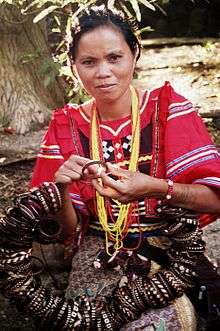
Bagobos live in an area that extends from Davao del Sur and South Cotabato to the foot of Mount Apo and Davao City all the way to the land bordered by the Davao and Pulangi rivers and up to northern Cotabato and southeast Bukidnon. Numbering about 80,000, their traditional costume is woven from abaca fiber and heavily ornamented with beads, shells, metal discs, embroidery and brightly colored geometric applique. Though Bagobos have the most stunning costumes among the Davao ethnic groups, they wear them only on special occasions. Like the Mandayas and Mansakas, they shave their eyebrows to a thin line and file and blacken their teeth. Bagobo smiths cast little bells which are attached to pouches, bracelets, jackets, anklets and inlaid metal boxes.
Tagacaolos number about 23,000 and occupy the area between the western shores of the gulf and the slopes of Mount Apo. This is one of the tribes which resisted Muslim conversion and maintained a highland animistic culture.
Kalagans are part Islamized and part Chistianized that is also related to the Tagacaolos. Numbering only about 7,000, they live along the shores of the Davao Gulf.
Mangguangans are now only 3,000. They can be found in Davao del Sur and Davao del Norte.
In both groups, women generally wear handwoven abaca tube skirts, embroidered blue cotton tops and heavy jewellery. Men sport wide blue or white fringed and embroidered trousers and a loose shirt. Red is a color only for a headman ("bagani") and for women of high status.
Aeta people
Aeta people live in some areas of Davao City all the way to Davao del Norte, Compostela Valley and Bukidnon. They are related to the Manobos of Cotabato and include sub-groups such as the Talaingod of the Kapalong forests in Davao del Norte and the Matigsalug. Numbering about 222,000, Ata men wear long-sleeved shirts, carry spears, hunt, log and grow crops. Their womenfolk wear native blouses, "malong" skirts and accessories of brass bracelets and bead necklaces. Mandaya and Mansaka are culturally related groups who are highly musical - playing the five string bamboo guitar, two-string lute, violin, flute, gong, drum and bamboo Jew's harp. They are also excellent silversmiths crafting breastplates, jewellery, daggers and knives. The Mandayas are famous for their colorful abaca fiber weaves embroidered with tribal motifs.
Art and culture
The colorful artistic heritage of Davao stems from the rich culture of its tribes. For the Bagobos, aesthetics is the meticulous carving of weapons; the elaborate decoration of inlaid metal boxes with bells; and the ornamentation of their abaca fiber dress with embroidery, shells, beads and metal discs. The Mandayas, on the other hand, have a solid tradition in weaving. To produce their famed coarse textured cloth, abaca fiber is colored with earth dyes and woven on a backstrap loom.
The final product is embroidered with bright-colored threads in geometric patterns. Some elements of tribal folklore are also included in the designs. The Mansakas, together with the Mandayas, are also expert silversmiths. They craft weapons, breastplates and dress accessories. Much of its people are Christians. Davao is also a harmonious blend of Christian and Muslim cultures. However, its most stunning cultural aspect is definitely its ethnic art which encompasses music, dance, religious ritual, dress and ornamentation.
Government
Governor
Vice Governor
|
Districts
|
See also
- Nueva Guipuzcoa Revolt
References
- "Province: Davao del Sur". PSGC Interactive. Makati City, Philippines: National Statistical Coordination Board. Archived from the original on 15 October 2007. Retrieved 1 May 2014.
- Census of Population (2015). "Region XI (Davao Region)". Total Population by Province, City, Municipality and Barangay. PSA. Retrieved 20 June 2016.
- Cayon, Carina L. (30 October 2013). "DavSur voters approve of Davao Occidental". Philippine Information Agency. Archived from the original on 3 December 2013. Retrieved 7 November 2013.
- "Province: Davao del Sur". PSGC Interactive. Quezon City, Philippines: Philippine Statistics Authority. Retrieved 8 January 2016.
- Census of Population and Housing (2010). "Region XI (Davao Region)". Total Population by Province, City, Municipality and Barangay. NSO. Retrieved 29 June 2016.
- "Weatherbase: Historical Weather for Davao del Sur, Philippines". Weatherbase. 2011. Retrieved 2011-07-15.
External links


- Davao City Travel and Tourism Guide
Places adjacent to Davao del Sur | |
|---|---|
Digos (capital) | |
| Municipalities | |
| Component City | |
| Highly urbanized city |
|
| Authority control |
|
|---|