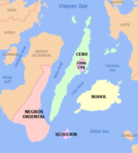
Siquijor
Siquijor (Pronounced as "See-Kee-Hor") (Cebuano: Lalawigan sa Siquijor, Tagalog: Lalawigan ng Siquijor) is a 5th provincial income class island province of the Philippines located in the Central Visayas region. Its capital is the municipality also named Siquijor. To the north of Siquijor is Cebu, to the west is Negros, northeast is Bohol, and to the south, across the Bohol Sea, is Mindanao.
Siquijor | |
|---|---|
.jpg) Island seascape | |
 Flag  Seal | |
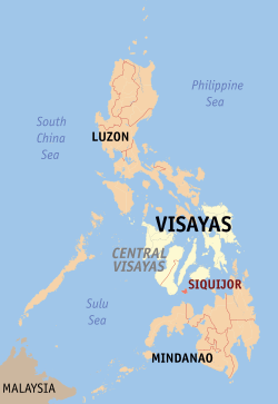 Location in the Philippines | |
| Coordinates: 9°11′N 123°34′E | |
| Country | Philippines |
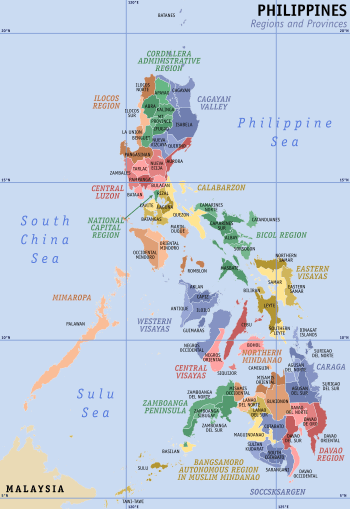
| Region | Central Visayas (Region VII) |
| Established | 17 September 1971 |
| Provincial Capital | Siquijor |
| Government | |
| • Type | Sangguniang Panlalawigan |
| • Governor of Siquijor[*] | Zaldy "Jecoy" S. Villa |
| • Vice Governor of Siquijor | Mei Ling M. Quezon |
| • Provincial Board | Members
|
| • Representative | Jake Vincent S. Villa |
| Area | |
| • Total | 337.49 km2 (130.31 sq mi) |
| Area rank | 79th of 81 |
| Highest elevation (Mount Malabahoc) | 628 m (2,060 ft) |
| Population (2015 census)[2] | |
| • Total | 95,984 |
| • Rank | 79th out of 81 |
| • Density | 280/km2 (740/sq mi) |
| • Density rank | 29th out of 81 |
| • Voter (2016)[3] | 68,988 |
| Demonym(s) | Siquijodnon |
| Divisions | |
| • Component cities | 0 |
| • Municipalities | |
| • Districts | Lone District of Siquijor |
| Time zone | UTC+08:00 (PST) |
| ZIP code | 6225–6230 |
| PSGC | |
| IDD : area code | +63 (0)35 |
| Income class | 5th class |
| Climate type | tropical monsoon climate |
| Website | www |
During the Spanish colonial period of the Philippines, the Spaniards called the island Isla del Fuego (Island of Fire). Siquijor is commonly associated with mystic traditions that the island's growing tourism industry capitalizes on.
History
Creation of the Island
A Siquijor legend tells of a great storm which once engulfed the region. Then there came a strong earthquake that shook the earth and sea. Amidst the lightning and thunder arose an island from the depths of the ocean's womb which came to be known as the island. Despite being a legend, modern times highland farmers have unraveled giant shell casings under farm plots, supporting the theory that Siquijor is indeed an island that rose from the sea.[4][5]
Precolonial Era
Prior to colonization, the island polity was home to the Kingdom (Kedatuan) of Katugasan, from tugas, the molave trees that cover the hills, which abounded the island along with fireflies. The "tugas" or molave trees were used by the ancient dwellers of the island in making posts or "haligi" of their houses because of its strength and durability that could withstand and struggle against strong typhoons and "habagat" and was proven by the house of "Totang" built near the artesian well of Cang-igdot. Most of the patriarchs of the island made the "tugas" trees to a wooden plow or "tukod" to cultivate the rocky soil for farming using mainly "toro" or male cattle to pull it through the sticky and hard rocky soil. However, before the discovery of making "tugas" as the foundations of their house, the primitive Siquijodnons dwelt in the caves as evidenced by the pottery and old tools like stone grinder or "liligsan" excavated by Mitring from the 3 caves of Sam-ang. During this time, the people of the kingdom was already in contact with Chinese traders, as seen through archaeological evidence including Chinese ceramics and other objects. The art of traditional healing and traditional witchcraft belief systems also developed within this period.[6] During the arrival of the Spanish, the monarch of the island was Datu Kihod, as recorded in Legazpi's chronicles.[7]
Spanish era
The island was first sighted by the Spaniards in 1565 during Miguel López de Legazpi's expedition. The Spaniards called the island Isla del Fuego ("Island of Fire"), because the island gave off an eerie glow, from the great swarms of fireflies that lived in the numerous molave trees on the island.[lower-alpha 1] Esteban Rodríguez of the Legazpi expedition led the first Spaniards to discover the island. He was captain of a small party that left Legazpi's camp in Bohol to explore the nearby islands which are now called Pamilican, Siquijor, and Negros
The island, along with the rest of the archipelago, was subsequently annexed to the Spanish Empire. Founded in 1783 under the administration of secular clergymen, Siquijor became the first municipality as well as the first parish to be established on the island. Siquijor was, from the beginning, administered by the Diocese of Cebu. As for civil administration, Siquijor was under Bohol since the province had its own governor. The first Augustinian Recollect priest arrived in Siquijor in 1794. Several years later, a priest of the same order founded the parishes of Larena (initially called Can‑oan), Lazi (formerly Tigbawan), San Juan (Makalipay), and Maria (Cang‑meniao). With the exception of Enrique Villanueva, the other five municipalities were established as parishes in 1877. From 1854 to 1892, Siquijor was part of the province of Negros Oriental, and became a sub-province in 1901.
American rule and World War II
At the turn of the century, Spain ceded the Philippines to the United States of America with the Treaty of Paris that ended the Spanish–American War. Siquijor island felt the presence of American rule when a unit of the American Cavalry Division came and stayed for sometime. The American Military Governor in Manila appointed James Fugate, a scout with the California Volunteers of the U.S. Infantry, to oversee and to implement the organization and development programs in Siquijor Island. Governor Fugate stayed for 16 years as lieutenant governor of Siquijor.[lower-alpha 2]
While it was not at the center of military action, Siquijor was not spared by World War II. Imperial Japanese detachments occupied the island between 1942 and 1943, announcing their arrival on the island with heavy shelling. At the outbreak of the war, Siquijor was a sub-province of Negros Oriental, headed by Lieutenant Governor Nicolas Parami. Refusing to pledge allegiance to the Japanese forces, Lt. Governor Parami was taken by Japanese soldiers from his residence at Poo, Lazi one evening and brought to the military headquarters in Larena. He was never heard from again. On 10 November 1942, Japanese warships started shelling Lazi from Cang‑abas Point. In Lazi, a garrison was established in the old Home Economics Building of the Central School. Filipino guerrillas engaged in sabotage and the interaction during this time caused havoc on the Japanese lives and properties.
During this period, Siquijor was briefly governed by Shunzo Suzuki, a Japanese civilian appointed by the Japanese forces until he was assassinated in October 1942 by the guerrilla forces led by Iluminado Jumawanin, of Caipilan, Siquijor. Mamor Fukuda took control of Siquijor from June 1943 until the Japanese forces abandoned the island when the liberation forces came in 1944. In 1943, the Japanese puppet government appointed Sebastian Monera of San Juan as Governor of Siquijor. His administration however was cut short when he was executed, presumably by Filipino guerrillas operating in the mountains of Siquijor.
On 30 September 1943, the United States submarine USS Bowfin (SS-287) delivered supplies to the people of Siquijor and evacuated people from the island.[10]
On 21 February 1945, the destroyer USS Renshaw (DD-499), part of Task Unit 78.7.6, was escorting a convoy of about 50 various landing ships with 12 other escorts. At 10:59, Renshaw was attacked by a Japanese midget submarine off the coast of Siquijor, which caused extensive damage to the ship and killed 19 of the crew.[11]
In mid-1945, local Filipino soldiers and officers under the 7th, 75th and 76th Infantry Division of the Philippine Commonwealth Army arrived, and alongside recognized guerrilla fighter groups, liberated Siquijor.
After 1945

For a time Siquijor was a subprovince of Negros Oriental, but it became an independent province on 17 September 1971, by virtue of Republic Act 6398. The move was supported by the people of Siquijor as they have a distinct culture from those of Negros Oriental, while Marcos used the movement as a means to secure support from the people of the island to pave martial law acceptance the following year.[12] The capital, formerly Larena, was transferred to the municipality of Siquijor in 1972 by Proclamation No. 1075, under martial law.[13]
In 2006, the Lazi Church was added by the government as an extension to the Baroque Churches of the Philippines UNESCO World Heritage Site. The inscription of the church has been pending since.[14]
Geography

Siquijor is an island province in Central Visayas. It lies southeast from Cebu and Negros across Cebu Strait (also called Bohol Strait) and southwest from Bohol. Panglao Island, which is part of Bohol province, has a similar composition of the soil which is found throughout the whole island of Siquijor.
With a land area of 327 square kilometres (126 sq mi) and a coastline 102 kilometres (63 mi) long, Siquijor is the third smallest province of the Philippines, both in terms of population as well as land area: (after Camiguin and Batanes).
Topography
The island lies about 19 kilometres (12 mi) east of the nearest point on southern Negros, 25 kilometres (16 mi) southeast of Cebu, 30 kilometres (19 mi) southwest of Bohol, and 45 kilometres (28 mi) north of Zamboanga del Norte in Mindanao. It is predominantly hilly and in many places the hills reach the sea, producing precipitous cliffs. At the center, Mount Malabahoc (locally known as Mount Bandila‑an) reaches about 628 metres (2,060 ft) in elevation, the highest point on the island. Three marine terraces can be roughly traced especially in the vicinity of Tag‑ibo on the southwestern part of the island, a barrio of San Juan municipality from the seacoast up into the central part.
Siquijor is a coralline island, and fossils of the giant clam tridacna are often encountered in the plowed inland fields. On the hilltops there are numerous shells of the molluscan species presently living in the seas around the island. Siquijor was probably formed quite recently, geologically speaking. The ocean depths between Siquijor and Bohol and Mindanao are in the neighborhood of 640 metres (350 fathoms; 2,100 feet).
Climate
Siquijor has two different climates, dominated by Am. All climate is within Coronas climate type IV,[15] characterised by not very pronounced maximum rainfall with a short dry season from one to three months and a wet season of nine to ten months. The dry season starts in February and lasts through April sometimes extending to mid‑May.
Five of the municipalities have significant rainfall most months of the year, with a short dry season that has little effect. This location is classified as Am (tropical monsoon climate) by Köppen–Geiger climate classification system. The average annual temperature in Siquijor is 27.6 °C (81.7 °F), with variation throughout the year less than 2 degrees Celsius (3.6 deg F). The precipitation about varies 165 millimetres (6 in) between the driest month and the wettest month, with the average rainfall 1,600 millimetres (63 in) or less.
The municipality Lazi has a significant amount of rainfall during the year. This is true even for the driest month. According to Köppen and Geiger, this climate is classified as Af (tropical rainforest climate). In a year, the average rainfall is 1,655 millimetres (65 in).
Administrative division
Siquijor (province) comprises 6 municipalities. Siquijor (municipality) is the capital and most important port.

| PSGC | City or Municipality | Population | ±% p.a. | Area | PD 2015 | Electorate | |||||||
|---|---|---|---|---|---|---|---|---|---|---|---|---|---|
| 2015[2] | 2010[16] | km2 | sq mi | /km2 | /sq mi | ||||||||
| 076101000 | 6.4% | 6,104 | 5,972 | 0.42% | 28.60 | 11.04 | 210 | 550 | 5,329 | 4,423 | |||
| 076102000 | 14.4% | 13,847 | 12,931 | 1.31% | 49.81 | 19.23 | 280 | 720 | 11,490 | 9,979 | |||
| 076103000 | 21.3% | 20,490 | 20,024 | 0.44% | 70.64 | 27.27 | 290 | 750 | 15,827 | 13,373 | |||
| 076104000 | 14.4% | 13,828 | 13,383 | 0.62% | 53.37 | 20.61 | 260 | 670 | 11,157 | 9,942 | |||
| 076105000 | 15.5% | 14,854 | 13,525 | 1.80% | 44.37 | 17.13 | 330 | 870 | 11,325 | 9,356 | |||
| 076106000 | 28.0% | 26,861 | 25,231 | 1.20% | 90.70 | 35.02 | 300 | 770 | 21,097 | 17,731 | |||
| TOTAL | 95,984 | 91,066 | 1.01% | 337.49 | 130.3 | 280 | 730 | 68,988 | 64,804 | ||||
| † |
Provincial capital |
|
Municipality | ||||||||||
The Lone district of Siquijor is the representation of the province in various national legislatures. The current representative is Jake Vincent S. Villa.
Demographics
| Population of Siquijor | |||||||||||||||||||||||||||||||||||||||||||||||||
|---|---|---|---|---|---|---|---|---|---|---|---|---|---|---|---|---|---|---|---|---|---|---|---|---|---|---|---|---|---|---|---|---|---|---|---|---|---|---|---|---|---|---|---|---|---|---|---|---|---|
|
| ||||||||||||||||||||||||||||||||||||||||||||||||
| Source: Philippine Statistics Authority[2][16][17] | |||||||||||||||||||||||||||||||||||||||||||||||||
According to the 2015 census, it has a population of 95,984.[2] The average annual growth rate between 2000 and 2015 was 1.09%, lower than the national growth rate of 1.87% for the same period.[2]
Languages
The main spoken language in the island province is Cebuano, with English often used as a second language. Tagalog is understood and used only in response to one who speaks it, but it is rarely used in everyday conversation. Some Spanish words are spoken and understood.
Religion
95% of the island's residents belong to the Catholic Church, while the remainder belong to various other Christian churches. Despite the province's Catholic affinities, almost all of the residents continue to adhere to traditional practices that were used prior the 15th century, albeit these practices have also adopted Christian belief systems as well. Due to the ingrained and indispensable traditional belief systems, majority of residents have continued to possess a high respect for the natural environment which was revered by the ancestors of the people. Siquijor is known for its unique Philippine culture of blending Catholicism with traditional religious practices - a major part of its people's cultural heritage and identity.
Education
The literacy rate of 92.5% is one of the highest in the country.[18]
Tourism
Siquijor's long-time reputation as a place of magic and sorcery both attracts and repulses visitors.[19] Siquijor is also well known for its festivals that focus on healing rituals where incantations are sung while the old folks make potions out of herbs, roots, insects and tree barks.
Among the many attractions are the beaches, caves, waterfalls, Bandila‑an natural park and butterfly sanctuary.[20][21][22][23] The most popular of them are the Cambugahay Falls and the old Balete tree, both located in Lazi.[24]
The coral reefs ringing the island offer some of the best diving in the Philippines for snorkelers and scuba divers. Dive courses are conducted by several dive operators on the island in version of PADI, CMAS* and NAUI. Siquijor was declared a marine visitor arrivals among the three provinces in Region VII.[25]
Transportation
The island of Siquijor has 2 seaports capable of servicing cargo and passenger sea crafts. Siquijor also has an airfield located near Siquijor capable of handling smaller and mostly privately-owned airplanes.
Gallery
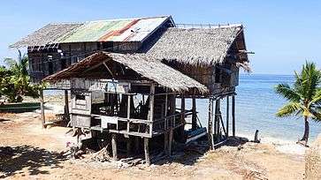 Cang‑Isok house, Enrique Villanueva, with time and ravages of the sea
 Sandugan Beach, Larena
 Cambugahay Falls, Lazi
 Salagdoong Beach, Maria
 St. Augustine of Hippo church, San Juan
.jpg) Façade of Saint Francis of Assisi church, Siquijor
Façade of Saint Francis of Assisi church, Siquijor
Notable people
- Datu Kihod - the last reigning monarch of the Kingdom of Katugasan, who reigned during the 16th century[26]
See also
Notes
- Lore – A folk legend also has it that many years ago, when the magical island of Siquijor was still nowhere on the face of the earth, a great storm engulfed the Visayan region, and a strong earthquake shook the earth and sea. Amidst the lightning and thunder arose an island from the depths of the ocean's womb which came to be known as the island of Siquijor, hence the name Isla del Fuego, or "Island of Fire." Oddly enough, in modern times, highland farmers have found giant shells under their farm plots, supporting the theory that Siquijor is indeed an island that rose from the sea.[8]
- After Siquijor, Fugate became governor of Sulu province, where he was murdered in 1938.[9]
References
- "Province: Siquijor". PSGC Interactive. Quezon City, Philippines: Philippine Statistics Authority. Retrieved 12 November 2016.
- Census of Population (2015). "Region VII (Central Visayas)". Total Population by Province, City, Municipality and Barangay. PSA. Retrieved 20 June 2016.
- "2016 National and Local Elections Statistics". Commission on Elections. 2016.
- https://dumagueteinfo.com/other-destinations/siquijor-island/siquijor-history/
- http://www.luzpalma.com/Information%20gather%20from%20the%20island%20of%20Siquijor.html
- https://www.dumagueteinfo.com/other-destinations/siquijor-island/siquijor-history/
- https://dumagueteinfo.com/other-destinations/siquijor-island/siquijor-history/
- "Siquijor History"
- Hayden 1937.
- Helgason, Guðmundur "Bowfin (SS-287)" Allied Warships uboat.net
- Hackett & Kingsepp 2006.
- Republic Act No. 6398 (17 September 1971), An Act separating the subprovince of Siquijor from the province of Oriental Negros and establishing it as an independent province, archived from the original on 2008-05-29, retrieved 8 February 2016CS1 maint: BOT: original-url status unknown (link)
- Presidential Proclamation No. 1075 (12 September 1972), Proclaiming the municipality of Siquijor as the capital of the province of Siquijor (s.1972), retrieved 8 February 2016
- https://whc.unesco.org/en/tentativelists/3860/
- Coronas 1920.
- Census of Population and Housing (2010). "Region VII (Central Visayas)". Total Population by Province, City, Municipality and Barangay. NSO. Retrieved 29 June 2016.
- Censuses of Population (1903–2007). "Region VII (Central Visayas)". Table 1. Population Enumerated in Various Censuses by Province/Highly Urbanized City: 1903 to 2007. NSO.
- Provincial Government of Siquijor 2012
- Philippine Daily Inquirer 2004
- Map "Tourist Spots: Province of Siquijor" GEOPLAN Cebu Foundation
- Visayan Daily Star 2009
- DOST 2008
- gmanews.tv, Butterfly sanctuary inaugurated in Siquijor
- http://trotterhop.com/philippines-cebu-siquijor-bohol/
- Cebu Daily News 2007
- http://www.luzpalma.com/Information%20gather%20from%20the%20island%20of%20Siquijor.html
Sources
- Cebu Daily News, Cris Evert Lato & Jun P. Tagalog (17 October 2007). "Neda: Tourism drove economy". Archived from the original on 21 August 2014.CS1 maint: ref=harv (link)
- Coronas, José (1920). The Climate and Weather of the Philippines, 1903 to 1918. Manila Observatory: Bureau of Philippines.CS1 maint: ref=harv (link)
- DOST, Mario P. de la Peña (2 October 2008). "Island butterfly sanctuary now open for tourists". Philippine Information Agency. Archived from the original on 2009-02-28.CS1 maint: ref=harv (link)
- Hackett, Bob; Kingsepp, Sander (2006). Sensuikan! Operational histories of Japanese submarines in WW II. Midget Submarines Based in the Philippines 1944-1945.CS1 maint: ref=harv (link)
- Hayden, Joseph Ralston, ed. (1937). "Fugate, James 1877-1938". Bentley Historical Library. U Michigan.CS1 maint: ref=harv (link)
- Philippine Daily Inquirer, Linda Bolido (24 October 2004). "Who's afraid of Siquijor?". Archived from the original on 25 January 2005.CS1 maint: ref=harv (link)
- "Geography". Provincial Government of Siquijor. 2012. Archived from the original on 2012-10-02. Retrieved 15 October 2012.CS1 maint: ref=harv (link)
- USS Bowfin (2002). "USS Bowfin Submarine Museum & Park". Patrol Summary. Archived from the original on 2016-05-04.CS1 maint: ref=harv (link)
- Visayan Daily Star, Rene Genove (10 October 2009). "Butterfly sanctuary launched in Siquijor". Archived from the original on 13 October 2008.CS1 maint: ref=harv (link)
External links
| Wikimedia Commons has media related to Siquijor. |

- Siquijor island - information
Places adjacent to Siquijor | ||||||||||
|---|---|---|---|---|---|---|---|---|---|---|
| ||||||||||
