List of lakes of the Philippines
The origin of most of the lakes in the Philippines is closely related to volcanic and tectonic activity. A number of smaller lakes occupy the craters of extinct volcanoes. Some lake basins are developed by subsidence due to tectonic or volcanic activity. Others owe their existence to obstruction of drainage courses by landslides, lava flows and by fragmental volcanic ejecta.[1][2]
Several lakes in the country are of volcanic origin like Lake Danao in Leyte province.
Among the lakes which are known in the Philippines only three, namely, Laguna de Bay in Luzon, Taal Lake in Luzon, and Lake Lanao in Mindanao, stand out prominently because of their size or economic importance.
List
The following is a partial alphabetical listing of permanent lakes (excluding flood plains) in the Philippines.
| Lake[3] | Type[2] | Area | Surface elevation (m.a.s.l.) |
Province | Region | Coordinates | Notes |
|---|---|---|---|---|---|---|---|
| Alligator | crater lake | 23 ha (57 acres) |
2 m (6 ft 7 in) |
Laguna | IV-A | 14°10′57″N 121°12′23″E | Also known as Lake Tadlac, it is located along the shore of Laguna de Bay in Brgy. Tadlac, Los Baños. |
| Ambuklao | reservoir | 383 ha (950 acres) |
761 m (2,497 ft) |
Benguet | CAR | 16°28′25″N 120°44′50″E | Created with the damming of Agno River |
| Apo | crater lake | 24 ha (59 acres) |
640 m (2,100 ft) |
Bukidnon | X | 7°52′45″N 125°0′21″E | Located in west of the city of Valencia |
| Baao | 177 ha (440 acres) |
5 m (16 ft) |
Camarines Sur | V | 13°27′56″N 123°18′53″E | ||
| Bababu | tectonic lake | 5 ha (12 acres) |
45 m (148 ft) |
Dinagat Islands | XIII | 10°4′28″N 125°30′33″E | |
| Balanan | landslide lake | 25 ha (62 acres) |
237 m (778 ft) |
Negros Oriental | XVIII | 9°8′16″N 122°59′55″E | Created after a landslide from the 1925 earthquake blocked the Balanan River |
| Balinsasayao | crater lake | 76 ha (190 acres) |
874 m (2,867 ft)[4] |
Negros Oriental | XVIII | 9°21′11″N 123°10′45″E | Twin lake of Lake Danao (Negros) |
| Basak | tectonic lake | 15 ha (37 acres) |
589 m (1,932 ft) |
Lanao del Sur | ARMM | 8°2′7″N 124°15′32″E | Located in Saguiaran, Lanao del Sur |
| Bato | 2,810 ha (6,900 acres) |
10 m (33 ft) |
Camarines Sur | V | 13°19′57″N 123°21′36″E | ||
| Bito | crater lake | 140 ha (350 acres) |
2 m (6 ft 7 in) |
Leyte | VIII | 10°47′19″N 124°58′49″E | |
| Buhi | landslide | 1,707 ha (4,220 acres) |
120 m (390 ft) |
Camarines Sur | V | 13°27′29″N 123°30′38″E | Formed after the non-volcanic earthquake of 1628 created a landslide which dammed the Barit River.[5] |
| Buluan | tectonic lake | 6,134 ha (15,160 acres) |
9 m (30 ft) |
Maguindanao & Sultan Kudarat |
ARMM & XII |
6°38′42″N 124°49′38″E | |
| Bulusan | 28 ha (69 acres) |
360 m (1,180 ft) |
Sorsogon | V | 12°45′16″N 124°5′37″E | ||
| Bunot | crater lake | 31 ha (77 acres) |
153 m (502 ft) |
Laguna | IV-A | 14°4′53″N 121°20′38″E | One of the seven lakes of San Pablo City |
| Butig | tectonic lake | 25 ha (62 acres) |
762 m (2,500 ft) |
Lanao del Sur | ARMM | 7°44′2″N 124°17′27″E | |
| Cabalian | crater lake | 15 ha (37 acres) |
733 m (2,405 ft) |
Leyte | VIII | 10°16′47″N 125°12′56″E | |
| Calibato | crater lake | 42 ha (100 acres) |
184 m (604 ft) |
Laguna | IV-A | 14°6′12″N 121°22′41″E | One of the seven lakes of San Pablo City |
| Caliraya | reservoir | 1,050 ha (2,600 acres) |
300 m (980 ft) |
Laguna | IV-A | 14°17′34″N 121°31′3″E | Created with the damming of Caliraya River |
| Caluangan | tectonic lake | 182 ha (450 acres) |
1 m (3 ft 3 in) |
Oriental Mindoro | IV-B | 13°22′11″N 121°8′11″E | Also known as Baruyan Lake |
| Camannauan | 3 ha (7.4 acres) |
13 m (43 ft) |
Cagayan | II | 18°13′29″N 121°46′49″E | ||
| Candelaria | 48 ha (120 acres) |
2 m (6 ft 7 in) |
Zambales | III | 15°36′38″N 119°56′34″E | ||
| Capahayan | crater lake[6] | 22 ha (54 acres) |
51 m (167 ft) |
Surigao del Norte | XIII | 9°32′25″N 125°34′47″E | Located in the town of Tubod |
| Catol | tectonic lake | 19 ha (47 acres) |
7 m (23 ft) |
Zambales | III | 15°37′17″N 119°56′26″E | Located in Brgy. Catol, the saltwater lake is one of the four lakes in Candelaria.[7] |
| Dagianan | crater lake | 3 ha (7.4 acres) |
1,231 m (4,039 ft) |
Lanao del Norte | X | 7°52′54″N 124°1′36″E | |
| Dakula | tectonic lake | 12 ha (30 acres) |
10 m (33 ft) |
Sulu | ARMM | 5°41′55″N 120°49′13″E | |
| Danao | crater lake | 18 ha (44 acres) |
304 m (997 ft) |
Albay | V | 13°21′33″N 123°34′24″E | Located in Polangui, Albay |
| Danao | tectonic lake | 680 ha (1,700 acres) |
5 m (16 ft) |
Cebu | VII | 10°40′25″N 124°20′19″E | Largest lake in the Visayas |
| Danao | tectonic lake | 148 ha (370 acres) |
650 m (2,130 ft) |
Leyte | VIII | 11°4′23″N 124°41′33″E | Centerpiece of Lake Danao Natural Park |
| Danao | crater lake | 28 ha (69 acres) |
898 m (2,946 ft) |
Negros Oriental | XVIII | 9°21′2″N 123°11′0″E | Twin lake of Lake Balinsasayao |
| Danao | crater lake | 4 ha (9.9 acres) |
450 m (1,480 ft) |
Sorsogon | V | 13°4′25″N 123°58′42″E | Located in the Pocdol Mountains near Bacon, Sorsogon |
| Dapao | tectonic lake | 1,012 ha (2,500 acres) |
960 m (3,150 ft) |
Lanao del Sur | ARMM | 7°47′12″N 124°2′36″E | |
| Dasay | 40 ha (99 acres) |
230 m (750 ft) |
Zamboanga del Sur | IX | 7°39′43″N 123°15′11″E | ||
| Duminagat | crater lake | 9 ha (22 acres) |
1,577 m (5,174 ft) |
Misamis Occidental | X | 8°18′25″N 123°36′57″E | Located inside Mount Malindang Range Natural Park[8] |
| Ernestine | crater lake | 35 ha (86 acres) |
3 m (9.8 ft) |
Tawi-Tawi | ARMM | 6°58′25″N 118°29′46″E | One of the three adjacent crater lakes in Mapun, one is open to the sea so is technically not a lake. |
| Gunao | crater lake | 23 ha (57 acres) |
117 m (384 ft) |
Quezon | IV-A | 14°0′4″N 121°22′17″E | |
| Himbang | tectonic lake | 26 ha (64 acres) |
14 m (46 ft) |
Agusan del Sur | XIII | 8°28′4″N 125°46′12″E | |
| Kabalin-an | crater lake | 2 ha (4.9 acres) |
824 m (2,703 ft) |
Negros Oriental | XVIII | 9°21′55″N 123°10′46″E | Located on the same caldera as Lakes Balinsasayao and Danao[9][10] |
| Kalanganan | tectonic lake | 12 ha (30 acres) |
512 m (1,680 ft) |
Lanao del Norte | X | 8°4′59″N 124°15′16″E | Located in Pantar |
| La Mesa | reservoir | 463 ha (1,140 acres) |
80 m (260 ft) |
None (located within Quezon City) | NCR | 14°43′1″N 121°4′46″E | Part of the Angat-Ipo-La Mesa water system, main source of water for Metro Manila |
| Laguna de Bay | tectonic lake | 93,000 ha (230,000 acres) |
2 m (6 ft 7 in) |
Cavite, Laguna, Rizal & Quezon |
IV-A&NCR | 14°20′N 121°17′E | Part of the lake is Laguna Caldera |
| Lanao | tectonic lake | 34,000 ha (84,000 acres) |
700 m (2,300 ft) |
Lanao del Sur | ARMM | 7°51′N 124°15′E | |
| Lanao | tectonic lake | 2 ha (4.9 acres) |
5 m (16 ft) |
Bohol | VII | 9°52′47″N 123°45′51″E | Also spelled "Danao", and also known as Cabilao Island Lake. Located on Cabilao Island[11] |
| Leonard | crater lake | 70 ha (170 acres) |
800 m (2,600 ft) |
Davao del Norte | XI | 7°23′37″N 126°3′32″E | Partially fills the 4 x 5 km Leonard Caldera |
| Libuao | crater lake | 24 ha (59 acres) |
800 m (2,600 ft) |
Occidental Mindoro | IV-B | 7°23′37″N 126°3′32″E | Named after the white lotus, Libua in Mangyan, that is abundant on the lake's surface[12][13] |
| Looc | tectonic lake | 113 ha (280 acres) |
34 m (112 ft) |
Zambales | III | 14°54′3″N 120°9′56″E | |
| Lumao | tectonic lake | 1,680 ha (4,200 acres) |
17 m (56 ft) |
Agusan del Sur | XIII | 8°26′39″N 125°46′23″E | |
| Lumot | reservoir | 582 ha (1,440 acres) |
300 m (980 ft) |
Laguna | IV-A | 14°15′16″N 121°32′59″E | Formed by the construction of Lumot Dam, damming Lumot River |
| Mabilog | crater lake | 2 ha (4.9 acres) |
1,605 m (5,266 ft) |
Negros Oriental | VII | 9°15′4″N 123°10′30″E | One of the two crater lakes of Cuernos de Negros[14] |
| Magat | reservoir | 1,122 ha (2,770 acres) |
192 m (630 ft) |
Ifugao & Isabela |
CAR & II |
16°49′30″N 121°25′33″E | Created with the damming of Magat River |
| Mahokdum | crater lake[6] | 22 ha (54 acres) |
190 m (620 ft) |
Surigao del Norte | XIII | 9°34′7″N 125°32′23″E | |
| Mainit | tectonic lake | 17,340 ha (42,800 acres) |
42 m (138 ft) |
Surigao del Norte & Agusan del Norte |
XIII | 9°27′31″N 125°31′10″E | Second deepest lake in the country at 223 m (732 ft) |
| Malimanga | tectonic lake | 12 ha (30 acres) |
7 m (23 ft) |
Zambales | III | 15°38′41″N 119°56′8.5″E | Located in Brgy. Malimanga, Candelaria, the lake is a protected bird and fish sanctuary since 1980.[15] |
| Manamlay | tectonic lake | 11 ha (27 acres) |
21 m (69 ft) |
Occidental Mindoro | IV-B | 12°59′7″N 120°51′23″E | Also known as Panikian Lake for the fruit bats that were abundant in the area.[13][16] |
| Manguao | tectonic lake | 741 ha (1,830 acres) |
21 m (69 ft) |
Palawan | IV-B | 10°45′46″N 119°33′1″E | |
| Mapanuepe | lahar-dammed | 648 ha (1,600 acres) |
129 m (423 ft) |
Zambales | III | 14°58′55″N 120°17′40″E | Created when lahar from Mount Pinatubo dammed the confluence of Mapanuepe and Marella Rivers. |
| Maughan | crater lake | 317 ha (780 acres) |
1,338 m (4,390 ft) |
South Cotabato | XII | 6°6′5″N 124°53′20″E | Created with the eruption of Parker Volcano on January 4, 1641 |
| Muhikap | crater lake | 15 ha (37 acres) |
80 m (260 ft) |
Laguna | IV-A | 14°7′20″N 121°20′3″E | One of the seven lakes of San Pablo City |
| Nag-aso Boiling | thermal lake | 3 ha (7.4 acres) |
35 m (115 ft) |
Albay | V | 13°7′27.8″N 123°54′28.10″E | Located in Brgy. Holugan, Manito, the hot spring that feed the lake with temperatures of about 100 °C (212 °F) is located in the NE corner of the lake.[17] |
| Nailig | crater lake | 11 ha (27 acres) |
1,599 m (5,246 ft) |
Negros Oriental | XVIII | 9°14′52″N 123°10′23″E | One of the two crater lakes of Cuernos de Negros[14] |
| Nalapan | tectonic lake | 3 ha (7.4 acres) |
515 m (1,690 ft) |
Davao del Sur | XI | 5°46′47″N 125°28′49″E | |
| Napalit | tectonic lake | 36 ha (89 acres) |
1,041 m (3,415 ft) |
Bukidnon | X | 7°52′5″N 124°47′3″E | |
| Naujan | tectonic lake | 8,125 ha (20,080 acres) |
20 m (66 ft) |
Oriental Mindoro | IV-B | 13°10′25″N 121°21′12″E | |
| Nunungan | 153 ha (380 acres) |
830 m (2,720 ft) |
Lanao del Norte | X | 7°49′21″N 123°57′19″E | ||
| Palakpakin | crater lake | 43 ha (110 acres) |
136 m (446 ft) |
Laguna | IV-A | 14°6′37″N 121°20′24″E | One of the seven lakes of San Pablo City |
| Panamao | crater lake | 68 ha (170 acres) |
114 m (374 ft) |
Sulu | ARMM | 5°58′11″N 121°10′13″E | One of the four crater lakes of Jolo island |
| Pandin | crater lake | 21 ha (52 acres) |
225 m (738 ft) |
Laguna | IV-A | 14°6′52″N 121°22′8″E | One of the seven lakes of San Pablo City |
| Pantabangan | reservoir | 5,923 ha (14,640 acres) |
202 m (663 ft) |
Nueva Ecija | III | 15°50′9″N 121°9′18″E | Largest man-made lake in the Philippines |
| Paoay | tectonic lake | 403 ha (1,000 acres) |
15 m (49 ft) |
Ilocos Norte | I | 18°7′12″N 120°32′4″E | |
| Pinag-ulbuan | crater lake | 2 ha (4.9 acres) |
19 m (62 ft) |
Batangas | IV-A | 14°1′21″N 121°0′54″E | Located on eastern side of Taal Volcano Island |
| Pinamaloy | tectonic lake | 60 ha (150 acres) |
312 m (1,024 ft) |
Bukidnon | X | 7°40′15″N 124°59′59″E | Also known as Lake Pinamalay |
| Pinatubo | crater lake | 183 ha (450 acres) |
926 m (3,038 ft) |
Zambales[18] | III | 15°8′37″N 120°20′56″E | Summit crater lake created after the 1991 eruption of Mount Pinatubo. Deepest lake in the country at 800 m (2,600 ft)[19] |
| Pulangi | reservoir | 1,985 ha (4,910 acres) |
340 m (1,120 ft) |
Bukidnon | X | 7°48′31″N 125°2′19″E | Powers Pulangi IV Hydroelectric Plant and provides drinking water for Bukidnon |
| Pulog | crater lake | 2 ha (4.9 acres) |
829 m (2,720 ft) |
Sorsogon | V | 13°2′33″N 123°58′55″E | On the summit of Mt. Pulog in the Pocdol Mountains near Bacon, Sorsogon |
| Sampaloc | crater lake | 104 ha (260 acres) |
134 m (440 ft) |
Laguna | IV-A | 14°4′42″N 121°19′49″E | One of the seven lakes of San Pablo City |
| San Marcos | lahar-dammed | 24 ha (59 acres) |
222 m (728 ft) |
Tarlac | III | 15°18′49″N 120°23′27″E | One of the lakes created by lahar from the 1991 eruption of Mount Pinatubo |
| San Roque | reservoir | 882 ha (2,180 acres) |
155 m (509 ft) |
Pangasinan & Benguet |
I & CAR |
16°9′38″N 120°41′28″E | The third reservoir on the Agno River after Ambuklao and Binga Lakes |
| Sani | crater lake | 11 ha (27 acres) |
130 m (430 ft) |
Sulu | ARMM | 5°56′4″N 121°21′0″E | One of the four crater lakes of Jolo island |
| Sapa | tectonic lake | 112 ha (280 acres) |
23 m (75 ft) |
Tawi-Tawi | ARMM | 7°0′37″N 118°29′28″E | |
| Sebu | 354 ha (870 acres) |
1,000 m (3,300 ft) |
South Cotabato | XII | 6°13′44″N 124°42′18″E | ||
| Seit | crater lake | 59 ha (150 acres) |
17 m (56 ft) |
Sulu | ARMM | 5°59′17″N 121°12′40″E | One of the four crater lakes of Jolo island |
| Singuan | crater lake | 112 ha (280 acres) |
23 m (75 ft) |
Tawi-Tawi | ARMM | 6°58′19″N 118°29′15″E | One of the three adjacent crater lakes in Mapun, one is open to the sea so is technically not a lake. |
| Sungculan | tectonic lake | 49 ha (120 acres) |
0 m (0 ft) |
Bohol | VII | 9°38′6″N 123°50′11″E | Sungculan is a saltwater lake located in Brgy. Songculan in Dauis[20] |
| Taal | 23,420 ha (57,900 acres) |
5 m (16 ft) |
Batangas | IV-A | 13°58′33″N 121°0′48″E | ||
| Taal Main Crater | crater lake | 121 ha (300 acres) |
5 m (16 ft) |
Batangas | IV-A | 14°0′41″N 120°59′52″E | |
| Tambo | lahar-dammed | 79 ha (200 acres) |
286 m (938 ft) |
Tarlac | III | 15°17′47″N 120°22′23″E | One of the lakes created by lahar from the 1991 eruption of Mount Pinatubo |
| Tikub | crater lake | 47 ha (120 acres) |
53 m (174 ft) |
Quezon | IV-A | 13°57′46″N 121°18′23″E | Also known as Lake Ticob, Ticab or Ticub |
| Timpuok | crater lake | 32 ha (79 acres) |
3 m (9.8 ft) |
Sulu | ARMM | 6°2′16″N 121°10′45″E | One of the four crater lakes of Jolo island |
| Tinagong Dagat | crater lake | 4 ha (9.9 acres) |
915 m (3,002 ft) |
Iloilo | VI | 11°4′31″N 122°19′42″E | Located in Lambunao, Iloilo. Possibly a crater lake. |
| Uacon | tectonic lake | 70 ha (170 acres) |
0 m (0 ft) |
Zambales | III | 15°40′19″N 119°56′24″E | Uacon Lake is a saltwater lake connected to the sea by a 2-km river.[21] |
| Uyaan | tectonic lake | 28 ha (69 acres) |
343 m (1,125 ft) |
Lanao del Sur | ARMM | 7°51′41″N 124°3′29″E | Also known as Lake Ugaan |
| Venado | tectonic lake | 2,194 m (7,198 ft) |
North Cotabato | XII | 7°0′11″N 125°16′3″E | Located on the slope of the tallest mountain in the Philippines, Mount Apo | |
| Wood | tectonic lake | 738 ha (1,820 acres) |
320 m (1,050 ft) |
Zamboanga del Sur | IX | 7°50′36″N 123°9′47″E | |
| Yagumyum | crater lake | 1 ha (2.5 acres) |
1,422 m (4,665 ft) |
Negros Oriental | XVIII | 9°15′3″N 123°11′12″E | Straddled between Talinis Peak and Yagumyum Peak of Cuernos de Negros[14] |
| Yambo | crater lake | 5 ha (12 acres) |
225 m (738 ft) |
Laguna | IV-A | 14°7′9″N 121°21′59″E | One of the seven crater lakes of San Pablo City |
Gallery
Largest and deepest lakes
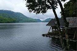
 Laguna de Bay, the largest lake in the Philippines
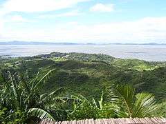
 Lake Lanao, second
 Taal Lake, third
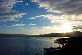 Lake Mainit, fourth, and the second deepest
See also
| Wikimedia Commons has media related to Lakes of the Philippines. |
References
- Pratt, Wallace E., Philippines Bureau of Science. "Philippine Journal of Science, Vol.XI No.5", p.223. Manila Bureau of Printing, 1917.
- "Lake Types". U.S. Environmental Protection Agency. Retrieved on June 12, 2011.
- "Philippine lakes". Index Mundi. Retrieved on June 12, 2011.
- "Philippine Lakes – Balukbaluk to Baranibud". Index Mundi. Retrieved on June 10, 2011.
- Paguican, Engielle Mae (2012_11). "Volcano-tectonic controls and emplacement kinematics of the Iriga debris avalanches (Philippines)". Academia.edu. Retrieved on December 30, 2013.
- "Paco – Synonym and Subfeatures". Global Volcanism Program. Retrieved on July 1, 2011.
- Lhars5 (August 14, 2011). "Fish Trap at Salt Lake Catol (Candelaria, Zambales)". Panoramio. Retrieved on 2012-05-19.
- "Mount Malindang Range Natural Park". UNESCO World Heritage Tentative List. Retrieved on August 28, 2011.
- heinzkieh (August 20, 2008). "Lake Kabalin-an" Archived March 27, 2012, at the Wayback Machine. Tampisaw sa Ulan. Retrieved on 2011-07-18.
- "Tourist Spots". Dumaguete Directory. Retrieved on July 18, 2011.
- (2006-03-18). "A Visit to Cabilao Island". Bohol Philippines "God's Little Paradise". Retrieved on July 13, 2011.
- simelguwapo (November 29, 2007). "Sablayan |About the Town". Sablayan, Occidental Mindoro. Retrieved on 2011-07-28.
- "Tourism". Occidental Mindoro Website. Retrieved on July 28, 2011.
- (2009-06-05). "Mt. Talinis/Bediao-Apolong Traverse to Casaroro Falls". Pinoy Mountaineer. Retrieved on July 18, 2011.
- "Protected areas in Region 3" Archived March 21, 2012, at the Wayback Machine. Protected Areas and Wildlife Bureau. Retrieved on May 19, 2012.
- Collar, N.J. and Mallari, Neil Aldrin D.. "Threatened birds of the Philippines", pg. 490. University of Michigan, 1999.
- Visit Legazpi (2012-0419). "Nag-aso Boiling Lake, Manito" Archived April 27, 2012, at the Wayback Machine. Wow Legazpi. Retrieved on May 19, 2012.
- U.S. Corps of Engineers. "Tarlac map". University of Texas in Austin Library. Retrieved on June 11, 2011.
- "Pinatubo" Archived January 29, 2009, at the Wayback Machine. Philippine Institute of Volcanoloty and Seismology. Retrieved on May 18, 2012.
- "Sungculan Lake". Google Maps. Retrieved on May 19, 2012.
- Arnell (May 7, 2006). "Uacon, Candelaria, Zambales, Philippines". Virtual Tourist. Retrieved on 2011-07-13.
Geography of the Philippines | ||
|---|---|---|
| Geology | 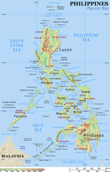 | |
| Landforms |
| |
| Water | ||
| Seas | ||
| Environment |
| |
List of lakes of Asia | |
|---|---|
| Sovereign states |
|
| States with limited recognition |
|
| Dependencies and other territories |
|
| |
This article is issued from Wikipedia. The text is licensed under Creative Commons - Attribution - Sharealike. Additional terms may apply for the media files.