Buenavista, Guimaras
Buenavista, officially the Municipality of Buenavista, is a 2nd class municipality and the largest settlement in the province of Guimaras, Philippines. According to the 2015 census, it has a population of 50,437 people.[3]
Buenavista | |
|---|---|
| Municipality of Buenavista | |
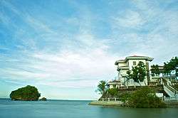 Roca Encantada House | |
 Map of Guimaras with Buenavista highlighted | |
OpenStreetMap 
| |
.svg.png) Buenavista Location within the Philippines | |
| Coordinates: 10°42′N 122°38′E | |
| Country | |
| Region | Western Visayas (Region VI) |
| Province | Guimaras |
| District | Lone district |
| Founded | 1775 |
| Barangays | 36 (see Barangays) |
| Government | |
| • Type | Sangguniang Bayan |
| • Mayor | Eugenio G. Reyes |
| • Vice Mayor | Cecile C. Gumarin |
| • Congressman | Ma. Lucille L. Nava |
| • Electorate | 35,006 voters (2019) |
| Area | |
| • Total | 128.26 km2 (49.52 sq mi) |
| Elevation | 70.6 m (231.6 ft) |
| Population (2015 census)[3] | |
| • Total | 50,437 |
| • Density | 390/km2 (1,000/sq mi) |
| • Households | 12,077 |
| Economy | |
| • Income class | 2nd municipal income class |
| • Poverty incidence | 18.36% (2015)[4] |
| • Revenue (₱) | 115,099,963.42 (2016) |
| Time zone | UTC+8 (PST) |
| ZIP code | 5044 |
| PSGC | |
| IDD : area code | +63 (0)33 |
| Climate type | tropical climate |
| Native languages | Hiligaynon Ati Tagalog |
| Website | buenavistaguimaras |
The town acts as a cheaper link between Panay and Negros, as opposed to taking a ship directly between the two islands.
Geography
Buenavista is located at the northern tip of Guimaras Island, and is one of the five towns comprising the province of Guimaras. The northern and north-west part of the town overlooks Panay Island and the north-east portion faces Negros Island. Iloilo Strait lies between the town and Panay, and Guimaras Strait lies between the town and Negros.[5] The McArthur wharf serves as the municipal wharf for Buenavista and part of San Lorenzo is used by passengers from the neighboring Panay Island in going to Negros Province and vice versa. This transportation route serves as a cheaper link, rather than taking a ship.
Buenavista's terrain ranges from plains (nearly level in the central and north-west coastal areas) to mountains (north-western part).[5]
Climate
The climate is mild and cool, due to its being bounded by the sea on the three directions.
| Climate data for Buenavista, Guimaras | |||||||||||||
|---|---|---|---|---|---|---|---|---|---|---|---|---|---|
| Month | Jan | Feb | Mar | Apr | May | Jun | Jul | Aug | Sep | Oct | Nov | Dec | Year |
| Average high °C (°F) | 30 (86) |
31 (88) |
32 (90) |
33 (91) |
32 (90) |
30 (86) |
29 (84) |
29 (84) |
28 (82) |
29 (84) |
30 (86) |
30 (86) |
30 (86) |
| Average low °C (°F) | 21 (70) |
21 (70) |
21 (70) |
23 (73) |
24 (75) |
24 (75) |
24 (75) |
24 (75) |
24 (75) |
24 (75) |
22 (72) |
21 (70) |
23 (73) |
| Average precipitation mm (inches) | 19 (0.7) |
17 (0.7) |
26 (1.0) |
37 (1.5) |
119 (4.7) |
191 (7.5) |
258 (10.2) |
260 (10.2) |
248 (9.8) |
196 (7.7) |
97 (3.8) |
39 (1.5) |
1,507 (59.3) |
| Average rainy days | 7.2 | 5.2 | 8.3 | 11.9 | 22.3 | 26.5 | 28.3 | 28.2 | 27.3 | 26.4 | 18.7 | 11.8 | 222.1 |
| Source: Meteoblue [6] | |||||||||||||
Barangays
Buenavista is politically subdivided into 36 barangays. [2]
- Agsanayan
- Avila
- Banban
- Bacjao (Calumingan)
- Cansilayan
- Dagsaan
- Daragan
- East Valencia (Mantangingi)
- Getulio (Ili)
- Mabini
- Magsaysay
- McLain
- Montpiller
- Navalas
- Nazaret
- New Poblacion (Calingao)
- Old Poblacion (Daan Banwa)
- Piña
- Rizal
- Salvacion (Ambulong)
- San Fernando
- San Isidro
- San Miguel
- San Nicolas (Tabao)
- San Pedro (Bating)
- San Roque
- Santo Rosario
- Sawang
- Supang
- Tacay
- Taminla(Sambag)
- Tanag
- Tastasan
- Tinadtaran
- Umilig
- Zaldivar
History
Buenavista is the oldest municipality on Guimaras. It was established in 1775, during the Spanish colonial period. A Spanish governor general was reputedly impressed by the scenery of the location, and called the place Buenavista, Spanish for "beautiful view".[5]
Santo Rosario was formerly known as Baybay, while Salvacion's old name was Ambulong, and furthermore Old Poblacion's name was Daan Banwa.
Demographics
| Population census of Buenavista | |||||||||||||||||||||||||||||||||||||||||||||||||
|---|---|---|---|---|---|---|---|---|---|---|---|---|---|---|---|---|---|---|---|---|---|---|---|---|---|---|---|---|---|---|---|---|---|---|---|---|---|---|---|---|---|---|---|---|---|---|---|---|---|
|
| ||||||||||||||||||||||||||||||||||||||||||||||||
| Source: Philippine Statistics Authority[3][7][8][9] | |||||||||||||||||||||||||||||||||||||||||||||||||
In the 2015 census, the population of Buenavista, Guimaras, was 50,437 people,[3] with a density of 390 inhabitants per square kilometre or 1,000 inhabitants per square mile.
Transportation
There are passenger ferries, utilizing pump boats to Iloilo City. The ferry terminal in Iloilo is on the Iloilo River.
Education
Buenavista is the center of higher education. In fact, the main campus of Guimaras State College, only state college in Guimaras, is found in Barangay Mclain. Furthermore, the municipality has 19 public elementary schools, 5 public high schools, and 1 vocational technical school.[5] It has a literacy rate of 98.4%, the highest in the whole of Guimaras.
References
- "Municipality". Quezon City, Philippines: Department of the Interior and Local Government. Retrieved 31 May 2013.
- "Province: Guimaras". PSGC Interactive. Quezon City, Philippines: Philippine Statistics Authority. Retrieved 12 November 2016.
- Census of Population (2015). "Region VI (Western Visayas)". Total Population by Province, City, Municipality and Barangay. PSA. Retrieved 20 June 2016.
- "PSA releases the 2015 Municipal and City Level Poverty Estimates". Quezon City, Philippines. Retrieved 12 October 2019.
- "Buenavista: Brief History and Profile". Province of Guimaras. Archived from the original on 2012-11-10. Retrieved 31 January 2013.
- "Buenavista: Average Temperatures and Rainfall". Meteoblue. Retrieved 28 April 2020.
- Census of Population and Housing (2010). "Region VI (Western Visayas)". Total Population by Province, City, Municipality and Barangay. NSO. Retrieved 29 June 2016.
- Censuses of Population (1903–2007). "Region VI (Western Visayas)". Table 1. Population Enumerated in Various Censuses by Province/Highly Urbanized City: 1903 to 2007. NSO.
- "Province of Guimaras". Municipality Population Data. Local Water Utilities Administration Research Division. Retrieved 17 December 2016.
External links
| Wikimedia Commons has media related to Buenavista, Guimaras. |
- Buenavista Profile at PhilAtlas.com
- Philippine Standard Geographic Code
- Philippine Census Information
| ||||||||||
Jordan (capital) | |
| Municipalities | |