Buruanga
Buruanga, officially the Municipality of Buruanga (Aklanon: Banwa it Buruanga; Hiligaynon: Banwa sang Buruanga; Tagalog: Bayan ng Buruanga), is a 5th class municipality in the province of Aklan, Philippines. According to the 2015 census, it has a population of 19,003 people.[4]
Buruanga | |
|---|---|
| Municipality of Buruanga | |
.jpeg) | |
 Seal | |
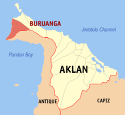 Map of Aklan with Buruanga highlighted | |
OpenStreetMap 
| |
.svg.png) Buruanga Location within the Philippines | |
| Coordinates: 11°50′38″N 121°53′20″E | |
| Country | |
| Region | Western Visayas (Region VI) |
| Province | Aklan |
| District | 2nd district of Aklan |
| Barangays | 15 (see Barangays) |
| Government | |
| • Type | Sangguniang Bayan |
| • Mayor | Concepcion D. Labindao |
| • Vice Mayor | Femy C. Dumaguin |
| • Congressman | Teodorico T. Haresco Jr. |
| • Electorate | 12,409 voters (2019) |
| Area | |
| • Total | 88.50 km2 (34.17 sq mi) |
| Elevation | 8.7 m (28.5 ft) |
| Population (2015 census)[4] | |
| • Total | 19,003 |
| • Density | 210/km2 (560/sq mi) |
| • Households | 4,219 |
| Economy | |
| • Income class | 5th municipal income class |
| • Poverty incidence | 24.41% (2015)[5] |
| • Revenue (₱) | 66,619,743.21 (2016) |
| Time zone | UTC+8 (PST) |
| ZIP code | 5609 |
| PSGC | |
| IDD : area code | +63 (0)36 |
| Climate type | tropical climate |
| Native languages | Aklan language Ati Hiligaynon Tagalog |
History
The name Buruanga came from the word Busuanga meaning "eruption" or "swell". Frequently harassed by inundations from the river, the early residents constructed earthen dams which were subsequently washed away. The people named the river "Busuanga," which later became the name of the Municipality. When the Spaniards arrived, they renamed Busuanga to Buruanga, or perhaps the change was purely a clerical error. The present municipality of Malay, including Boracay, was once a part of Buruanga. On June 15, 1949, the enactment of Republic Act 391 separated Malay from Buruanga to become an independent municipality.[6]
It was hit severely by typhoon Seniang on 9–10 December 2006, with much destruction and damage of homes and infrastructure.[7]
Geography
Buruanga is located at the western tip of Panay Island. It is a coastal town bounded on the north by Malay; south by Libertad, Antique; and west by the Cuyo East Pass of the Sulu Sea. It is 81 kilometres (50 mi) from the provincial capital Kalibo.
According to the Philippine Statistics Authority, the municipality has a land area of 88.50 square kilometres (34.17 sq mi) [2] constituting 4.86% of the 1,821.42-square-kilometre- (703.25 sq mi) total area of Aklan.
Climate
There is one prevailing type of climate identified as Type I, two pronounced seasons which are dry from November to April and wet for the rest of the year. This is also true in all municipalities of Western Aklan such as Malay (excluding Boracay Island) and Nabas, as well as the Western portion of the municipalities bounding Antique.
In these areas, including Buruanga, the wettest month is August with rainfall averaging 625 millimetres (24.6 in) and the driest is March with rainfall of only about 150 millimetres (5.9 in). The average temperature if the area is 27.9 °C (82.2 °F) with an average humidity of 77.8%. The wet season coincides with the planting of rice while offshore fishing is in full gear during the dry season. Typhoons and strong winds rarely occur, and if it ever occurs, it coincides with the wet season. The humid north-western monsoon arrives in the area by June causing an increase in rainfall which reaches its peak in the month of August.
| Climate data for Buruanga, Aklan | |||||||||||||
|---|---|---|---|---|---|---|---|---|---|---|---|---|---|
| Month | Jan | Feb | Mar | Apr | May | Jun | Jul | Aug | Sep | Oct | Nov | Dec | Year |
| Average high °C (°F) | 28 (82) |
29 (84) |
30 (86) |
32 (90) |
32 (90) |
31 (88) |
30 (86) |
30 (86) |
29 (84) |
29 (84) |
29 (84) |
28 (82) |
30 (86) |
| Average low °C (°F) | 23 (73) |
22 (72) |
23 (73) |
24 (75) |
25 (77) |
25 (77) |
25 (77) |
24 (75) |
24 (75) |
24 (75) |
24 (75) |
23 (73) |
24 (75) |
| Average precipitation mm (inches) | 47 (1.9) |
33 (1.3) |
39 (1.5) |
48 (1.9) |
98 (3.9) |
150 (5.9) |
169 (6.7) |
147 (5.8) |
163 (6.4) |
172 (6.8) |
118 (4.6) |
80 (3.1) |
1,264 (49.8) |
| Average rainy days | 11.4 | 8.2 | 9.3 | 9.7 | 19.1 | 25.6 | 27.4 | 25.5 | 25.5 | 25.2 | 18.5 | 14.5 | 219.9 |
| Source: Meteoblue [8] (Use with caution: this is modeled/calculated data, not measured locally.) | |||||||||||||
Barangays
Buruanga is politically subdivided into 15 barangays.[9]
| PSGC | Barangay | Population | ±% p.a. | |||
|---|---|---|---|---|---|---|
| 2015[4] | 2010[10] | |||||
| 060405001 | Alegria | 9.0% | 1,709 | 1,695 | 0.16% | |
| 060405002 | Bagongbayan | 5.5% | 1,050 | 951 | 1.90% | |
| 060405003 | Balusbos | 5.7% | 1,085 | 930 | 2.98% | |
| 060405004 | Bel-is | 3.8% | 722 | 695 | 0.73% | |
| 060405005 | Cabugan | 4.6% | 882 | 696 | 4.61% | |
| 060405006 | El Progreso | 6.0% | 1,147 | 946 | 3.74% | |
| 060405007 | Habana | 9.7% | 1,850 | 1,605 | 2.74% | |
| 060405008 | Katipunan | 10.6% | 2,006 | 1,708 | 3.11% | |
| 060405009 | Mayapay | 5.8% | 1,106 | 1,033 | 1.31% | |
| 060405010 | Nazareth | 10.1% | 1,923 | 1,696 | 2.42% | |
| 060405011 | Panilongan | 6.2% | 1,186 | 1,062 | 2.12% | |
| 060405012 | Poblacion | 5.6% | 1,062 | 1,116 | −0.94% | |
| 060405013 | Santander | 7.0% | 1,330 | 1,210 | 1.82% | |
| 060405014 | Tag-osip | 1.6% | 299 | 255 | 3.08% | |
| 060405015 | Tigum | 8.7% | 1,646 | 1,364 | 3.64% | |
| Total | 19,003 | 16,962 | 2.19% | |||
Demographics
| Population census of Buruanga | |||||||||||||||||||||||||||||||||||||||||||||||||
|---|---|---|---|---|---|---|---|---|---|---|---|---|---|---|---|---|---|---|---|---|---|---|---|---|---|---|---|---|---|---|---|---|---|---|---|---|---|---|---|---|---|---|---|---|---|---|---|---|---|
|
| ||||||||||||||||||||||||||||||||||||||||||||||||
| Source: Philippine Statistics Authority[4][10][11][12] | |||||||||||||||||||||||||||||||||||||||||||||||||
In the 2015 census, Buruanga had a population of 19,003.[4] The population density was 210 inhabitants per square kilometre (540/sq mi).
Tourism
Despite its proximity to Boracay, one of the most popular tourist destinations in the Philippines, Buruanga sees very few tourists. Various scenic spots such as caves, waterfalls, beaches, hills, and mountain parks are found throughout the area such as the Hinugtan White Beach, Batason (Ariel’s) Point, Langka Beach, Nasog Beach, Tuburan Baybay Beach, Tigis Beach/Falls, and Pagatpat Mangrove Park.
Flora and fauna
The upland barangay of Tag-Osip contains a portion of the Northwest Panay Peninsula Natural Park which is contained within the municipalities of Buruanga, Malay, and Nabas in Aklan Province and Libertad and Pandan in Antique. The park is home to many important plant and animal species such as the Visayan leopard cat, the blue-necked parrot, the Visayan hornbill, and the roughneck monitor lizard.[13]
In 2011, several researchers from the United States Peace Corps conducted various biological assessments along the Buruanga coastline. It was found that Buruanga hosts 4 different species of mangroves including large tracts of nypa found in the barangays of Alegria, Balusbos, Poblacion, and Santander. Other species including pagatpat, bakawan, and piyapi are concentrated in Pagatpat Mangrove Park in barangay Panilongan with a few trees in spotted areas in barangay Santander. Buruanga also is home to 5 different species of seagrass identified including Cymodocea rotundata, Cymodocea serrulata, Halodule pinifolia, Halophila ovalis and Thalassia hemprichii.
References
- "Municipality". Quezon City, Philippines: Department of the Interior and Local Government. Retrieved 31 May 2013.
- "Province: Aklan". PSGC Interactive. Quezon City, Philippines: Philippine Statistics Authority. Retrieved 12 November 2016.
- "Buruanga, Aklan Profile". PhilAtlas.com. Retrieved 15 June 2020.
- Census of Population (2015). "Region VI (Western Visayas)". Total Population by Province, City, Municipality and Barangay. PSA. Retrieved 20 June 2016.
- "PSA releases the 2015 Municipal and City Level Poverty Estimates". Quezon City, Philippines. Retrieved 12 October 2019.
- "Republic Act No. 381; an Act Creating the Municipality of Malay in the Province of Capiz". PhilippineLaw.info. 15 June 1949. Archived from the original on 22 October 2014. Retrieved 20 October 2016.
- Villanueva, VG (20 December 2006). "Aklan final tally from typhoon Seniang: P479-M in damages". Philippine Information Agency. Archived from the original on 20 October 2016. Retrieved 20 October 2016.
- "Buruanga: Average Temperatures and Rainfall". Meteoblue. Retrieved 1 May 2020.
- "Municipal: Buruanga". PSGC Interactive. Quezon City, Philippines: Philippine Statistics Authority. Retrieved 8 January 2016.
- Census of Population and Housing (2010). "Region VI (Western Visayas)". Total Population by Province, City, Municipality and Barangay. NSO. Retrieved 29 June 2016.
- Censuses of Population (1903–2007). "Region VI (Western Visayas)". Table 1. Population Enumerated in Various Censuses by Province/Highly Urbanized City: 1903 to 2007. NSO.
- "Province of Aklan". Municipality Population Data. Local Water Utilities Administration Research Division. Retrieved 17 December 2016.
- "Panay Eco-Social Conservation Project". Panay Eco-Social Conservation Project. Conservation Biology Unit, Ruhr-University Bochum. 30 August 2013. Archived from the original on 4 March 2016. Retrieved 20 October 2016.
External links
![]()
Places adjacent to Buruanga | ||||||||||
|---|---|---|---|---|---|---|---|---|---|---|
| ||||||||||