Laguna (province)
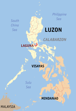
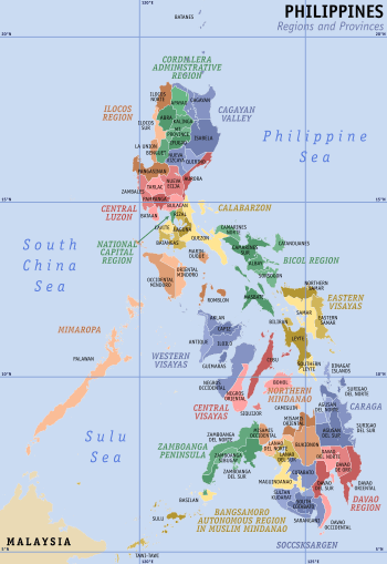
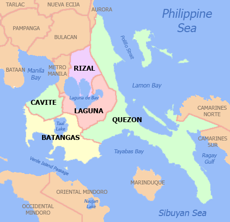
Laguna, officially the Province of Laguna (Tagalog: Lalawigan ng Laguna; Spanish: Provincia de Laguna), is a province in the Philippines, located in the Calabarzon region in Luzon. Its capital is Santa Cruz and the province is situated southeast of Metro Manila, south of the province of Rizal, west of Quezon, north of Batangas and east of Cavite. Laguna hugs the southern shores of Laguna de Bay, the largest lake in the country. As of the 2015 census, the province's total population is 3,035,081[4]. It is also currently the seventh richest province in the country.[5]
Laguna | |
|---|---|
| Province of Laguna | |
 Laguna Provincial Capitol | |
 Flag  Seal | |
| Motto(s): "Laban, Laguna!" | |
 Location in the Philippines | |
| Coordinates: 14°10′N 121°20′E | |
| Country | Philippines |
| Region | Calabarzon (Region IV-A) |
| Founded | July 28, 1571[1][2] |
| Capital | Santa Cruz |
| Government | |
| • Type | Sangguniang Panlalawigan |
| • Governor | Ramil Hernandez (PDP-Laban) |
| • Vice Governor | Katherine C. Agapay (PDP-Laban) |
| Area | |
| • Total | 1,917.85 km2 (740.49 sq mi) |
| Area rank | 63rd out of 81 |
| Highest elevation | 2,170 m (7,120 ft) |
| Population (2015 census)[4] | |
| • Total | 3,035,081 |
| • Rank | 3rd out of 81 |
| • Density | 1,600/km2 (4,100/sq mi) |
| • Density rank | 3rd out of 81 |
| Divisions | |
| • Independent cities | 0 |
| • Component cities | |
| • Municipalities | |
| • Barangays | 681 |
| • Districts | |
| Demographics | |
| • Ethnic groups | |
| Time zone | UTC+8 (PHT) |
| ZIP Code | 4000–4033 |
| IDD : area code | +63 (0)49 |
| ISO 3166 code | PH |
| Spoken languages | |
| HDI | |
| HDI rank | 8th (2015) |
| Website | www |
Laguna is notable as the birthplace of Jose Rizal, the country's national hero. It is also famous for attractions like Pagsanjan Falls, the University of the Philippines Los Baños and the University of the Philippines Open University in Los Baños , the hot spring resorts of Calamba on the slopes of Mount Makiling, Pila historic town plaza, Taytay Falls in Majayjay, the wood carvings and papier-mâché created by the people of Paeté, the annual Sampaguita Festival in San Pedro, the turumba of Pakil, the tsinelas footwears from Liliw, the Pandan Festival of Luisiana, the Seven Lakes of San Pablo, and the Nagcarlan Underground Cemetery in Nagcarlan.
History
Pre-Hispanic Era
The history of the province of Laguna, and that of the Southern Tagalog region, dates as far back as 900 AD. The Laguna Copperplate Inscription is the oldest known written document found in the Philippines, which talks of its subject being released from a debt to the King of Tondo. Pre-Hispanic settlement in the area can be dated to prehistoric times, as evidenced in the names of towns such as Pila, Laguna, whose name can be traced to the straight mounds of dirt that form the boundaries of the rice paddy, or Pilapil.
A prominent figure during the time of pre-Hispanic contact is Gat Pangil, a chieftain in the area. The towns of Bay, Pangil and Pakil were reputed to have once been a part of his domain, although accounts vary on who exactly Gat Pangil was.
16th Century
The Province of Laguna, which was formerly called La Laguna and La Provincia de la Laguna de Bay, was named after Laguna de Bay, the body of water that forms its northern boundary.[6] Laguna de Bay, in turn, was named after the town of Bay, the first provincial capital. Captain Juan de Salcedo with a band of one hundred Spanish-Mexican soldiers conquered the province and its surrounding regions for Spain in 1571. The province of La Laguna comprised the modern province of Laguna, as well as parts of what is now known as Rizal and Quezon.
In 1577, the Franciscan missionaries arrived in Manila, and in 1578 they started evangelizing Laguna, Morong (now Rizal), Tayabas (now Quezon) and the Bicol Peninsula. Juan de Plasencia and Diego de Oropesa were the earliest Franciscans sent to these places. From 1580, the towns of Bay, Caliraya, Majayjay, Nagcarlan, Liliw, Pila, Santa Cruz, Lumban, Pangil and Siniloan were founded. During the time of Governor-General Gomez Perez Dasmarinas, the province of La Laguna was divided into the following encomiendas:[7][8][9]
- Mirabago - Currently the areas surrounding, Liliw, and Nagcarlan.
- Tabuco - Currently the areas surrounding San Pedro, Biñan, Santa Rosa, Cabuyao, and Calamba.
- Taitay - Currently Taytay, Rizal.
- Bay - The area surrounding Bay, Laguna, and Los Baños, Laguna.
- Pila - The area that is now Pila, Victoria, Pililla, Rizal, and Jala-Jala, Rizal
- Mahaihai - Currently the area around Majayjay, Magdalena, and Luisiana
- Lumbang - The largest encomienda, containing what is now known as Lumban, Santa Cruz, Paete, Pakil, Cavinti, and Pagsanjan.
- Tayaval - Tayabas, now known as Quezon.
- Panguil - Now Pangil, Laguna.
- Sinaloa - The area surrounding Siniloan, Famy and Mabitac.
- Moron - Currently the areas surrounding Morong, including the town of Santa Maria, formerly known as Caboan.
- Nayun - Nayum, Currently Tiaong, Quezon.
By 1591, there were approximately 48,400 people living in the province.
17th and 18th Century
Laguna was the site of multiple engagements during the Sangley Rebellion.[6] In 1603, Antonio de Morga relates how the Chinese rebels scattered to three divisions, one of which went to the mountains of San Pablo.[10] Captain Don Luys de Velasco, aided by Spanish and Filipino forces, was successful in pursuing the rebels. Eventually the Chinese were able to kill Luys de Velasco and ten of his men, before securing themselves in San Pablo while waiting for reinforcement from the mainland. On the 20th of October, 1603, Governor-General Pedro Bravo de Acuña then sent Captain Cristoval de Axqueta Menchaca to pursue and crush the rebellion and was successful after twenty days of fighting.
Around this time the hot springs of Los Baños and San Pablo were known to the Spanish, and a hospital was built in the area. By 1622 the hospital was notable enough to be mentioned by the Archbishop of Manila at the time, Miguel García Serrano in his letter to King Philip IV.[11]
In 1639, a second rebellion involving the Chinese occurred, and the rebels fortified themselves in the highlands of Cavinti and Lumban before surrendering in Pagsanjan a year later.
In 1670, a delimitation of borders were made between Lucban, Majayjay and Cavite. The most populous town at that time, Bay, was capital of the province until 1688, when the seat of the provincial government was moved to Pagsanján. Pagsanján would be the provincial seat until 1858 when it was moved once again to Santa Cruz. In 1754, the Province of Laguna and Tayabas were divided, with the Malinao River separating the towns of Majayjay and Lucban.[12]
In 1678, Fray Hernando Cabrera founded San Pablo de los Montes (now San Pablo City) and built a wooden church and convent considered as the best and finest in the province.[12]
Fighting extended to Laguna during the British occupation of Manila between the years of 1762-64. A detachment of British troops under Captain Thomas Backhouse entered the province in search of the silver cargo of the galleon Filipina while Francisco de San Juan led a band of volunteers that fought them in several engagements in and around the then provincial capital of Pagsanjan. Backhouse plundered the town and burned its newly reconstructed church but San Juan succeeded in escaping with the precious hoard to Pampanga where the treasure greatly bolstered the defense effort of Governor-General Simón de Anda y Salazar. For his actions, San Juan was made a brigade commander and alcalde mayor of Tayabas (now Quezon) province.[12]
19th Century
A major event in Laguna occurred in 1840, when religious intolerance led the people of Majayjay, Nagcarlan, Bay, and Biñan to join the revolt of Hermano Pule (Apolinario de la Cruz) of Lucban, Tayabas.[12] This revolt was eventually crushed by Governor-General Marcelino de Oraá Lecumberri.
As part of political restructuring during the 19th century, the municipalities of Morong, Pililla, Tanay, Baras, Binangonan, Jalajala, Angono and Cardona were separated from Laguna and re-organized to the province Politico-Militar Distrito de Morong. In 1858, the provincial capital was once again moved from Pagsanjan to Santa Cruz, where it stands until today.
In 1861, José Rizal was born in Calamba to Francisco Mercado and Teodora Alonso. Rizal would become one of the leading members of the Propaganda Movement, who advocated political reforms for the colony. Rizal would go on to write two novels, Noli Me Tangere and El Filibusterismo, which in part fueled additional anti-colonial sentiment, contributing to the eventual Philippine Revolution. In 1896, thousands of inhabitants, especially of Bay, Los Baños, Nagcarlan, Magdalena, Santa Cruz, and Pagsanjan had joined the revolutionary Katipunan.[12] Rizal was executed on December 30, 1896, on charges of rebellion. Today Rizal is recognized as one of the national heroes of the Philippines.
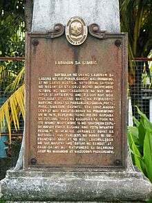
Laguna was one of the eight provinces to rise in revolt against the Spanish misrule led by Generals Paciano Rizal of Calamba, Severino Taiño of Pagsanjan, Agueda Kahabagan of Calauan, and Miguel Malvar of Batangas.[6] One of the early engagements of the revolution was the Battle of Sambat, in Pagsanjan. Katipuneros from Laguna, led by Severino Taiño, took the city of Pagsanjan and attempted to use it as a starting point towards the liberation of the province, but was quelled by forces led by Basilio Augustin.[13]
The defeat in Sambat meant the end of large-scale organized revolt in Laguna, the Malungingnging chapter of the Katipunan failing to replicate the relative success of the revolution in Cavite. The revolutionaries resorted to hit-and-run and guerrilla tactics against the Spanish, lasting until the Pact of Biak-na-Bato on December 14 to 15, 1897.[12] It was only after the execution of Jose Rizal that the revolution flared up again, culminating in the Battle of Calamba in May 1898, and the surrender of the last Spanish garrison in Laguna in Santa Cruz, on August 31 of the same year.
Laguna actively supported the First Philippine Republic proclaimed at Malolos on January 23, 1899. Its two delegates to the Malolos Congress were Don Higino Benítez and Don Graciano Cordero, both natives of Pagsanján.[12]
20th Century
Upon the outbreak of the Philippine–American War, Generals Juan Cailles and Paciano Rizal led the defense of Laguna during the war's early stages. The Battle of Mabitac was fought in defense of the town of Mabitac and was won by Filipino forces. However, forces led by Henry W. Lawton fought and won in Santa Cruz, Pagsanjan, and Paete, effectively securing the province for American forces. Resistance still occurred during this time. One of the province's folk hero during the continuing engagements was Teodoro Asedillo, who was considered a bandit by American forces.
By the end of the war, the entire country was occupied by American forces and was taken as a colony. The Taft Commission was established to govern the Philippines during the interim period, which appointed Juan Cailles as the provincial governor of Laguna. Act No. 83, or the Provincial Government Act, established a civilian government under American occupation. During this time, roads were built, schools were established, and in 1917, the Manila Railroad Company extended its line to Laguna as far as Pagsanjan.
During the Japanese occupation of the Philippines (1942–1945), Laguna was a center of Filipino resistance despite the presence of Makapili collaborators.[12]
Marking's Guerrillas raided the Cine Lumban in Laguna in June 1942 in an attempt to free the 115 American POWs. Only one American was rescued, Corporal George Lightman of the 3rd Pursuit Squadron, because the ranking American captain ordered his men to stay where they were. The Japanese executed 10 American prisoners in retribution.[14][15]
The establishment of the military general headquarters and military camp bases of the Philippine Commonwealth Army and the Philippine Constabulary is a military unit organization was founded on January 3, 1942 to June 30, 1946 in the province of Laguna, and aided of the local military regular units of the Philippine Commonwealth Army 4th and 42nd Infantry Division and the Philippine Constabulary 4th Constabulary Regiment. Started the engagements of the Anti-Japanese Military Operations in Southern Luzon, Mindoro and Palawan from 1942 to 1945 against the Japanese Imperial forces.
Beginning in 1945, attacks by the Filipino soldiers of the 4th, 42nd, 43rd, 45th, 46th and 47th Infantry Division of the Philippine Commonwealth Army, 4th Constabulary Regiment of the Philippine Constabulary and the recognized guerrillas against Japanese forces in Laguna increased in anticipation of the Liberation of the Philippines by joint Filipino & American forces.
Geography
Laguna covers a total area of 1,917.85 km2 (740.49 sq mi)[16] occupying the north‑central section of the Calabarzon region in Luzon. The province is situated southeast of Metro Manila, south of Rizal, west of Quezon, north of Batangas and east of Cavite. Laguna is the third largest province in the Calabarzon region and the 63rd largest in the entire country. The municipalities of Cavinti and the city of San Pablo have the largest land areas with 203.58 km2 (78.60 sq mi) and 197.56 km2 (76.28 sq mi), respectively. The municipality of Victoria has the smallest land area with 57.46 km2 (22.19 sq mi).
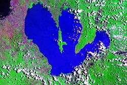
Laguna lies on the southern shores of Laguna de Bay, the largest lake in the country. The land near Laguna de Bay can be considered to be narrow and flat, while become more rugged going further inland towards the mountainous areas of Sierra Madre, Mount Makiling, and Mount Banahaw.[17]

Laguna is home to 24 mountains, most of which are inactive volcanoes. The highest peak in Laguna is Mt. Banahaw, with an elevation of 2,170 m (7,120 ft). Banahaw, unlike most other volcanoes in Laguna, is an active complex stratovolcano, which last erupted in 1843. Banahaw is located in the boundary of Laguna and Quezon and is home to multiple hot springs.[18] Laguna is also home to the Laguna Volcanic Field, which can be found near San Pablo. The Laguna Volcanic Field is composed of over 200 dormant and monogenetic maars, crater lakes, scoria cones and stratovolcanoes, the tallest of which is Mount Makiling at 1,090 m (3,580 ft) in elevation.
San Pablo itself is known for its seven crater lakes, the largest of which is Lake Sampaloc. Apart from the Laguna de Bay and the Seven Lakes of San Pablo, there are also two reservoir lakes that can be found in Laguna, the Lake Caliraya and Lumot Lake. These two man-made lakes were formed by the creation of the Caliraya Dam and the Lumot Dam.
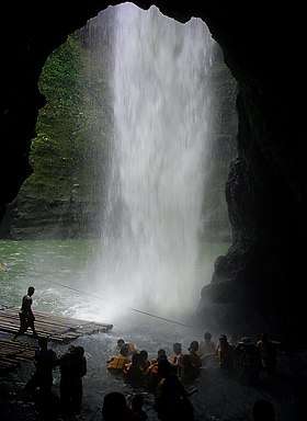
Due to its proximity to Laguna de Bay, Laguna is home to a large number of its tributaries. One of the most famous rivers in Laguna is the Bumbungan River, also known as the Pagsanjan River, named after the town of Pagsanjan and its falls. The Pagsanjan Falls lie at the end of the river. The Pagsanjan Falls are a three-drop waterfall with a longest drop of 120 m (390 ft).
Laguna has 60,624 ha (606.24 km2) of alienable and disposable agricultural land, mostly found near the low-lying areas. Around 41,253 ha (412.53 km2), or 23.44% of Laguna's total land area is forest land, situated near Mount Makiling and further south towards Quezon.[19] Laguna has an estimated 16,205 ha (162.05 km2) of forest cover, ranking it third in the region.[20]
Climate
The province is relatively dry from November to April and wet during the rest of the year for a small portion near the southern boundary. The other parts, west of Santa Cruz municipality, experience a dry season from November to April and rainy season during the rest of the year. The eastern and southern most portions do not have distinct season, with rainfall more evenly distributed throughout the year.[21] Laguna is classified under the Köppen climate classification as predominantly having a Tropical monsoon climate, mostly centered around the areas of Calamba to Calauan. The area stretching from Biñan to Cabuyao is classified as having a Tropical savanna climate, while the area from Luisiana to Pangil has a Tropical rainforest climate.[22]
Administrative divisions

Laguna comprises 24 municipalities and 6 cities. The provincial capital of Laguna is Santa Cruz. As of the 2015 census, there are 3,035,081 people in the province.[4]
- † Capital municipality
- ∗ Component city
- Municipality
| |||||||||||||||||||||||||||||||||||||||||||||||||||||||||||||||||||||||||||||||||||||||||||||||||||||||||||||||||||||||||||||||||||||||||||||||||||||||||||||||||||||||||||||||||||||||||||||||||||||||||||||||||||||||||||||||||||||||||||||||||||||||||||||||||||||||||||||||||||||||||||||||||||||||||||||||||||||||||||||||||||||||||||||||||||||||||||||||||||||||||||||||||||||||||||||||||||||||||||||||||||||||||||||||||||||||||||||||||||
Demographics
| Population census of Laguna | |||||||||||||||||||||||||||||||||||||||||||||||||
|---|---|---|---|---|---|---|---|---|---|---|---|---|---|---|---|---|---|---|---|---|---|---|---|---|---|---|---|---|---|---|---|---|---|---|---|---|---|---|---|---|---|---|---|---|---|---|---|---|---|
|
| ||||||||||||||||||||||||||||||||||||||||||||||||
| Sources: Philippine Statistics Authority[4][23][29] | |||||||||||||||||||||||||||||||||||||||||||||||||
The population of Laguna in the 2015 census was 3,035,081 people,[4] with a density of 1,600 inhabitants per square kilometre or 4,100 inhabitants per square mile. Calamba is the most populous city in Laguna, accounting for 15% of the provincial population with 454,486 inhabitants, while Famy is the smallest municipality in Laguna with a total population of 16,587. In terms of population density, San Pedro has the largest with a density of 14,000/km2 (36,000/sq mi), while Cavinti is the smallest with a density of 110/km2 (280/sq mi). Most of the people in Laguna live in the cities of San Pedro, Biñan, Santa Rosa, Cabuyao, and Calamba, accounting to 58.51% of the population of the province. Laguna is the 3rd most populous province in the Philippines and also the 3rd densest. Laguna has a median age of 24.9 years.[30]
Being in the middle of the Southern Tagalog Region, almost all people in Laguna speak Tagalog, with 99.2% of the population being fluent in it. There is a minority of people fluent in Ilocano, Bicolano and Waray. A significant portion of the workforce in Laguna can read and speak English and Filipino.[31] In 2000, literacy in Laguna was at 96.22%.[30]
Religion
Laguna was historically one of the first provinces in the Philippines to have been visited by Christian missionaries. Today, the province, like the rest of the country, is predominantly Christian, with most being a part of the Roman Catholic Church. The Diocese of San Pablo is the only Roman Catholic diocese in Laguna. Other Christian denominations present in Laguna are the Philippine Independent Church, the Iglesia ni Cristo, Baptists, Ang Dating Daan and other Mainline Protestants. Most non-Christians in Laguna practice Islam, Anitism, animism, or atheism.
Economy
 Muntinlupa-San Pedro Arch-Bridge, the boundary between Metro Manila and Laguna Province/Calabarzon.
 Southwoods Mall in Biñan City, Laguna
 The view of the city proper of Santa Rosa in Laguna
 The St. Polycarp Parish in Cabuyao beside the city plaza
 An aerial view of Calamba City
 Jose Rizal Avenue in San Pablo City, Laguna
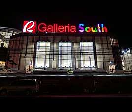 Robinsons Galleria South in San Pedro City, Laguna
Present-day Laguna shows a thriving economy. With a population of 3,035,081 (2015 census),[4] and a total area of 1,760 km2 (680 sq mi) of land, Laguna produces millions of pesos worth of coconuts, rice, sugar, citrus fruits, lanzones and other products. Tourists flock to its beauty spots, especially Pagsanjan Falls, Calamba and Los Baños hot springs, Mount Makiling, Caliraya Lake and many others. Levels of development vary. The towns near Metro Manila have become industrialized whereas the inner towns continue to engage in agricultural production or pursue agri-based industries and cottage and small-scale industries.[12] In 2015, Laguna was reported to have an equity of PHP 4.474 billion, the second highest in the region behind Cavite.[32]
Laguna is labeled as the Detroit of the Philippines because of the presence of major vehicle manufacturers in the city of Santa Rosa. It is also considered as the Silicon Valley of the Philippines because of the vast number of electronic and semi-conductor companies operating in the province. Laguna is also the Resort Capital of the Philippines for it houses more than 700 hot spring resorts in the areas of Calamba and Los Baños.[33][19]
Natural resources
The main natural resources of Laguna are in its agriculture and fisheries, owing to its position near the Laguna de Bay and the surrounding lowlands.
There are about forty rivers in Laguna with a total area of almost 0.5 km2 (0.19 sq mi). The Laguna de Bay has an approximate area of 3,800 square kilometres (1,500 sq mi) broken down into 2,900 square kilometres (1,100 sq mi) of land and 900 km2 (350 sq mi) of lake proper with 220 kilometres (140 mi) shoreline. The shores of Laguna de Bay provide fishing grounds capable of producing 41,000 metric tons (41,000,000 kg) of fish, or roughly two-thirds of the fresh water fish requirements of Metro Manila.[19]
Laguna has an estimated 300 million US gallons (1,100,000 m³) of underground water. At least seven principal water basins in the province with a total of 5,773 square kilometres (2,229 sq mi) drainage area and 1,316 square kilometres (508 sq mi) level area provide an estimated 9.238 square kilometres (3.567 sq mi) total run-off annually.[19] There are two major watershed reserves in Laguna, the Malabanban Cabunsod Watershed Forest Reserve in San Pablo, and the Caliraya-Lumot River Watershed Forest Reserve, which spans the municipalities of Paete, Cavinti, Kalayaan, and Lumban. Overall, these two watersheds span an area of 11,164.71 ha (27,588.6 acres).[34]
Laguna has a relatively small mining industry compared to the other provinces in the region, with only 11 non-metallic mines registered in the region, and only 8 of which are operating. These mines are found in Santa Cruz, Magdalena, Siniloan, Lumban, and San Pablo. A total of 39.7823 ha (0.397823 km2) are used for mining purposes.[35] Aggregates make up the largest amount in Laguna's mineral industry, with a value of PHP 16,995,923. Overall, Laguna's mining economy contributes 8.87% to the region's total mining economy.[36]
Agricultural activities
Laguna has 60,624 hectares (149,810 acres) of alienable and disposable agricultural land. About 41,253 hectares (101,940 acres) or 23.44% of Laguna's total land area is forest land.[19] In 2002, there were 38,445 farms in Laguna. The top five crops produced in Laguna are rice, maize, coconuts, mangoes, and bananas.[30] Other crops grown in the province include Robusta coffee,[37] pineapple, lanzones, rambutan,[38] and sugarcane.[39] Calamba was once the site of a sugar cane mill, although the decline of the sugar industry during the 1970s and 1980s resulted in its eventual shutdown.
Rice farming is an important part of Laguna's agriculture, with approximately 30,619 ha (306.19 km2) of land used for cultivating 130,904 metric tons (130,904,000 kg) of rice.[30] Los Baños is also the site of multiple research institutions specializing in rice, such as the International Rice Research Institute (IRRI), the ASEAN Center for Biodiversity (ACB) and the Southeast Asian Regional center for Graduate Study and Research in Agriculture (SEARCA), among others.[19]
Laguna de Bay, with a surface area of 900 kilometres (560 mi), is the province's main fishing ground producing 410,000 metric tons (410,000,000 kg) of fish. Carp and tilapia fingerlings are also being grown in inland ponds and freshwater fish pens. There are a total of 457 operators utilizing an area of 1,839 ha (18.39 km2) for fish pens and fish cages. Aside from the Laguna de Bay, approximately 12% of the area in the Seven Lakes of San Pablo is being used for aquaculture.
Industry and commerce
Laguna is home to twenty-one economic zones as registered under the Philippine Economic Zone Authority.[40] Most of these economic zones are located in Santa Rosa, Biñan, and Calamba. The largest economic zone in Laguna is the Laguna Technopark, located in Santa Rosa and Biñan, with an area of 337.215 hectares (3.37215 km2). Laguna is home to a large automotive industry, with Toyota Motor Philippines, Nissan Motor Philippines, Honda Philippines Incorporated, and Mitsubishi Motors Philippines all having plants in Santa Rosa.
Laguna has a growing business process outsourcing industry, with companies such as IBM and Convergys establishing offices in Santa Rosa. PEZA lists 4 IT parks and 1 IT Center in Laguna. [40] Business districts and shopping malls continues to arise bringing opportunities and attractive places to dine and relax.
Infrastructure
Road network
_-_Carmona_(Carmona%2C_Cavite%3B_2017-03-16).jpg)
Laguna has a total of 348 kilometres (216 mi) of national roads, all paved.[41] Daang Maharlika (Route 1, AH26), Calamba - Santa Cruz - Pagsanjan Road(Route 66) and Manila East Road (Route 601, Route 602, Route 603), and San Pablo - Calauan Road (Route 67), form the highway network backbone, and secondary and tertiary national roads interconnect most municipalities, with Magdalena only connected by provincial road. Provincial roads serves as a supplement to the national roads, and connects barangays and municipalities not connected to the main network. The highway network is interconnected with nearby provinces and Metro Manila.
The South Luzon Expressway (SLEx) passes through Laguna. A public-private partnership initiative of the national government include plans to build a circumferential road along Laguna de Bay shoreline, the Laguna de Bay Flood Control Dike Expressway (or C-6 Extension),[42] from San Pedro to Siniloan. Some of the proposed road networks is the Calamba-Los Baños Expressway[19][43] and the Cavite–Laguna Expressway that will connect the provinces of Cavite and Laguna.
Power
Three power generating plants are operating in the province.[19]
- Botocan Hydro-electric Plant (25MW) — Majayjay
- Caliraya Hydro-electric Plant (23.5 MW) — Kalayaan
- Mak-Ban Geothermal Plant (20MW) — Bay

Meralco, the main electricity distributor of Metro Manila, has also the franchise for most of Laguna.[19] Most of the municipalities on the 4th District, however, are franchise areas of First Laguna Electric Cooperative (FLECO).
Government

The seat of the provincial government of Laguna is Santa Cruz, and has been the capital since 1858. Historically, the provincial government was seated in Bay (1581-1688) and Pagsanjan (1688-1858) before setting in Santa Cruz.
The provincial government is organized under a governor and vice governor, as well as the Laguna Provincial Board. Laguna is divided to four districts for the purposes of electing members of the provincial board. On a municipal level, the province is governed by mayors and their own legislatures, the Sangguniang Panlungsod and Sangguniang Bayan for cities and municipalities, respectively. Each municipality is further composed for barangays, which are headed by a Punong Barangay and legislated by a Sangguniang Barangay.
Provincial Government
The governor of Laguna is Ramil Hernandez, who is a member of the Nacionalista Party.
| Governor | |||
|---|---|---|---|
| Ramil Hernandez | |||
| Vice Governor | |||
| Katherine Agapay | |||
| Provincial Board | |||
| 1st District | Ma. Rene Anne Lourdes G. Matibag (PDPLBN) | Jose Magtanggol C. Carait III (NP) | Abigael D. Alonte (NP) |
| 2nd District | Christian Niño S. Lajara (NP) | Peewee P. Perez (PDPLBN) | Neptali P. Bagnes (PFP) |
| 3rd District | Angelica B. Alarva(PFP) | Alejandro Y. Yu (NP) | |
| 4th District | Ma. Jamina Katherine B. Agarao (PDPLBN) | Rai-ann Agustine San Luis (NP) | |
House of Representatives
On the legislative level, the province is divided into six legislative districts, each of which elect their own representative to the House of Representatives. Of the five available seats for Laguna, 4 of them were won by members of the Liberal Party. The 3rd District was won by Sol Aragones, who is a member of the United Nationalist Alliance. The newest district, the Lone District of the City of Calamba, will have its first election in 2019.[44]
| District | Representative |
|---|---|
| 1st District | Danilo Fernandez |
| 2nd District | Ruth Hernandez |
| 3rd District | Sol Aragones |
| 4th District | Benjamin Agarao |
| Lone District of Biñan | Marlyn Alonte-Naguiat |
| Lone District of the City of Calamba | Joaquin Chipeco |
- Legend:
- Nacionalista Party
- Partido Demokratiko Pilipino-Lakas ng Bayan
Arts and culture
Laguna is a major contributor to the development of arts in the Philippines. Paete is known as the Woodcarving Capital of the Philippines[45] for the murals found in the Saint James the Apostle Parish Church. The church houses three murals created by Luciano Dans depicting images of Heaven, Earth, and Hell, as well as other murals of Saint Christopher. Some of these murals, however, need restoration as they have been infested by termites. Manuel Baldemor is an internationally acclaimed woodcarver born in Paete. Another famous icon in Laguna is the Our Lady of Turumba, found in Pakil.
Much like the rest of the country, Laguna celebrates multiple feasts and festivals throughout the year. Each barangay has their own fiesta in homage to a patron saint. Some of Laguna's famous festivals include the Turumba Festival in Pakil, the Pinya Festival in Calauan, and the Tsinelas Festival in Liliw.
Tourism
Laguna has a large tourist industry, owing to its historical and natural resources. The Department of Tourism currently accredits two hotels, one inn, six resorts, one establishment, one restaurant, four tour operations, four tour guides, and two museums in the province.[46] Laguna also has a total of 239 accredited tourist attractions, the second largest in the region behind Batangas. Tourism in Laguna is large, although most of the visitors to tourist spots are foreigners, as opposed to other provinces in Calabarzon.[47]
_(Calamba%2C_Laguna%3B_2017-02-16).jpg)
Owing to its long history, Laguna has a host of sites that showcase the different periods of history in Laguna. The Rizal Shrine in Calamba is the ancestral home of the Philippines' national hero, Jose Rizal. Other historical sites include the Alberto House in Biñan, the Cuartel de Santo Domingo in Santa Rosa, the Pagsanjan Municipal Hall, the Pagsanjan Arch, the Nagcarlan Underground Cemetery, the ancestral homes and Pinagbayanan crematorium in Pila, Emilio Jacinto Shrine in Santa Cruz, the Baker Memorial Hall in UP Los Baños, and the Tipakan in Luisiana.
Other historical markers include the Japanese Garden in Cavinti and the Homma-Yamashita Shrine in Los Baños, both of which commemorate the Japanese occupation of the Philippines during the Second World War, the memorial sites of the Battle of Sambat in Pagsanjan and the Battle of Mabitac in Mabitac, and the Bantayog ng Kagitingan, Bantayog ng mga Bayani, Trece Martires Monument, and the Bonifacio Monument in San Pablo.[48]
There are multiple historical and educational museums in Laguna in addition to its historical sites, such as the Pila Memorial Museum in Pila, the Salvador Laurel Museum and Library in San Pedro,[49] the Museo de Santa Rosa in Santa Rosa, the Danilo Daleňa House of Paintings in Pakil, the Bahay Laguna in Magdalena, and the Monterola Museum in Nagcarlan.[50] Los Baños is home to multiple museums, such as the IRRI Riceworld Museum, the Museum of Natural History, the Museum of the Wildlife Collections of Dr. Dioscoro Rabor, and the Entomology Museum.[51]
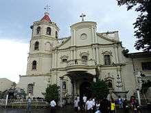
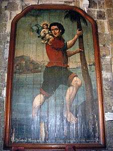
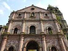
Laguna is home to some of the oldest churches in the Philippines, dating back to the end of the 16th century. The St. James the Apostle Parish Church in Paete, and the Saint Gregory the Great Parish Church in Majayjay are considered to be some of the oldest in the province, dating as far back as 1578 and 1571, respectively.
Other historical churches in the provinces include the Saint Paul the First Hermit Cathedral in San Pablo, the Transfiguration of our Lord Parish Church in Cavinti, the Nuestra Señora de Candelaria Parish Church in Mabitac, the Immaculate Conception Parish Church in Los Baños, the Saint John the Baptist Church in Liliw, the St. John the Baptist Church in Calamba, where Rizal was baptized, the Saint Peter of Alcantara Parish Church in Pakil, which houses the Our Lady of Turumba painting, the Immaculate Conception Parish Church in Santa Cruz, St. Polycarp Church and the Diocesan Shrine of San Vicente Ferrer in Cabuyao, Santa Rose de Lima Parish Church in Santa Rosa, and the Diocesan Shrine of Jesus in the holy Sepulchre (Lolo Uweng) and the San Pedro Apostol Parish Church in San Pedro. Lolo Uweng Church was known as the Quiapo Church of the South.[52]
Laguna contains many natural tourist spots, owing to its geography and climate. Laguna is home to the Laguna Volcanic Field, a group of 200 volcanoes and maars. The highest feature of these fields is Mount Makiling, which is also considered to be a holy mountain. The Seven Lakes of San Pablo are also part of this field. The highest peak in Laguna is Mount Banahaw, which it shares with the province of Quezon. Laguna also features multiple waterfalls, such as the Pagsanjan Falls, the Buruwisan Falls in Siniloan, the Botocan and Taytay Falls in Majayjay, the Talon ng Aliw and the Hulugan Falls, both in Luisiana. Other attractions in the province include the Cavinti Underground River and Caves Complex, the Simbahang Bato in Luisiana, the Dalitiwan River in Majayjay, and the Crocodile Park in Los Baños.[53]
There are also multiple man-made tourist attractions and parks located in Laguna. The Enchanted Kingdom theme park is found in Santa Rosa and is accredited by the Department of Tourism. Other parks in Laguna include the Valesol Haven, the Boy Scouts of the Philippines Camp, the Maria Makiling Park, and the Makiling Botanical Garden, all found in Los Baños; the Wawa Park in Paete, and the Public Plaza of San Pablo.
Calamba and Los Baños are famous for its resorts and hot springs, lending to it the title of Resort Capital of the Philippines. Other sites include the Turumba Swimming Pool in Pakil, the Caliraya Lake, Dagatan Boulevard in San Pablo, and the Sampaloc Lake Staircase.[54]
Education
Education rates in Laguna are high. In 2010 there were approximately 2,382,512 out of 2,669,847 people having attained some form of education. The literacy rate of Laguna in 2000 was 96.22%.[30] Most people in Laguna are high school graduates, while most overseas workers from Laguna have a college degree.
There are 586 public schools in Laguna, composed of 458 public schools and 128 secondary schools. The city of San Pablo has the greatest number of public schools with 79, while the municipality of Rizal has the least with four.[55]
Laguna is home to multiple schools and universities. There are an estimated 18 universities and 37 colleges in the province. There are 3 state universities in Laguna with a total of 11 campuses: Laguna State Polytechnic University, Pamantasan ng Cabuyao, Polytechnic University of the Philippines, and the University of the Philippines Los Baños. UPLB is also one of the oldest universities in the Philippines, having been established in 1909. The International Rice Research Institute can be found within the UPLB campus and is known internationally for its work in developing rice technologies.
There are also multiple private colleges in Laguna. Some colleges and universities with main campuses in Metro Manila have also established satellite campuses in Laguna, such as Lyceum of the Philippines University-Laguna, De La Salle Canlubang, Colegio de San Juan de Letran, and Malayan Colleges Laguna. Most recently the University of Santo Tomas has announced that it will establish a campus in Santa Rosa.
Notable alumni from colleges in Laguna include Teodoro Casiño, a former member of the House of Representatives; Eduardo Cojuangco Jr., the chairman of San Miguel Corporation; and Jerrold Tarog, film director.
Notable people
- José Rizal, writer, propagandist, national hero of the Philippines
- Paciano Rizal, military general and revolutionary; older brother of José Rizal
- Pedro Pelaez, educator, priest, known as the Father of Filipinization of the Church
- Ambrosio Rianzares Bautista, lawyer and author of the Declaration of Philippine Independence
- Marcelo Adonay, Filipino church composer, musician, organist, musical director, and music teacher
- Agueda Kahabagan, Filipina general of the Philippine Revolutionary Army
- Saturnina Rizal Hidalgo, José Rizal's eldest sister
- Delfina Herbosa de Natividad, one of the three women, together with Marcela Agoncillo and her daughter Lorenza, who seamed together the Flag of the Philippines. Niece of José Rizal.
- Vicente Lim, World War II general
- Encarnacion Alzona - National Scientist of the Philippines for Philippine History
- Dioscoro L. Umali - National Scientist of the Philippines for Agriculture and Rural Development
- Eduardo Quisumbing - National Scientist of the Philippines for Plant Taxonomy, Systematics, and Morphology
- Dolores Ramirez – National Scientist of the Philippines for Biochemical Genetics & Cytogenetics
- Bienvenido O. Juliano – National Scientist of the Philippines for Biochemistry
- Gelia Tagumpay Castillo – National Scientist of the Philippines for Rural Sociology
- Emil Q. Javier, National Scientist of the Philippines for Agriculture, and 17th President of the University of the Philippines
- Gregorio F. Zaide, historian, author, known as the Dean of Filipino Historiographers
- Leandro H. Fernandez - educator, author and historian
- Cielito Habito, economist, professor, former NEDA Director-General
- Alfredo E. Evangelista, archaeologist
- Francisco E. Baisas, entomologist regarded as the "Dean of Philippine Culicidologists"
- José Fabella - Filipino physician and a public health advocate, Father of Public Health and Social Welfare in the Philippines.
- Pedro Guevara, soldier, lawyer, and legislator
- Crispin Oben, lawyer, member of the First Philippine Assembly
- Estanislao Fernandez, lawyer, former Associate Justice of the Supreme Court of the Philippines
- Conrado Benitez - First Dean of College of Liberal Arts at the University of the Philippines, educator and author, one of the drafters of the Philippines' 1935 constitution.
- Ernesto Maceda, former councilor of Manila, Senate President, columnist, and lawyer
- Joey Lina, former governor, senator and DILG secretary, current DZMM radio program anchor and Manila Bulletin columnist
- Leo M. Drona, Catholic Priest. Second Bishop of the Diocese of San Jose, Nueva Ecija and Third Bishop of the Roman Catholic Diocese of San Pablo, Laguna.
- Celso Ad. Castillo, film director and screenwriter.
- Sol Aragones, former news reporter and host of ABS-CBN News and Current Affairs, incumbent legislator
- Ariella Arida, fashion model, television personality, Miss Universe-Philippines 2013, Miss Universe 2013 3rd Runner-up
- Charice Pempengco, singer
- Angeli Gonzales, actress
- Bayani Casimiro, tap dancer
- Alfie Anido, actor, matinee idol
- Flor Contemplacion, domestic worker
- Ronato Alcano, professional pool player
- Rico Blanco, singer, songwriter
- Julia Clarete, host, singer, actress
- Mario Montenegro, actor
- Paw Diaz, actress, model, TV host
- Dion Ignacio, actor
- Louie Ignacio, TV director
- C. J. Muere, actor
- Ronnie Alonte, actor, singer, dancer, It's Showtime, Hashtags member
- Jane De Leon, It's Showtime GirlTrend member, Actress.
- Didith Reyes, actress, singer
- Sabrina Man, child actress
- Alden Richards, model and actor
- Sabrina, singer
- Princess Snell, actress
- Halina Perez, model, actress
- Carmina Villaroel, actress
- Charo Ronquillo, fashion model
- Led Sobrepeña III, singer of The Singing Bee, actor, and comedian
- Charlene Almarvez, fashion model
- Jedah Hernandez, beauty pageant titleholder
- Barbie Forteza, actress, model
- Joan Da, Finalist of the X Factor Philippines
- Thea Tolentino, female winner of GMA Network's Protégé Season 2
- Jeric Gonzales, male winner of GMA Network's Protégé Season 2
- Jak Roberto, actor, model
- Sanya Lopez, actress, model
- Stephanie Retuya, contestant and runner-up in Asia's Next Top Model (cycle 1)
- HaveYouSeenThisGirl, author of the books Diary ng Panget, Voiceless and She Died
See also
References
- "28 JULY 1571: The Foundation date of the Province of Laguna". Academia.edu.
- Young historian finds Laguna birth date|Inquirer News Archived 2012-10-08 at the Wayback Machine
- "List of Provinces". PSGC Interactive. Makati City, Philippines: National Statistical Coordination Board. Archived from the original on 11 January 2013. Retrieved 18 November 2013.
- Census of Population (2015). Highlights of the Philippine Population 2015 Census of Population. PSA. Retrieved 20 June 2016.
- "Here are the Philippines' richest cities, provinces and towns in 2016 - Philstar.com". The Philippine Star.
- "History of Laguna". Calirayalake.com. Retrieved 23 June 2016.
- Blair, Emma Helen; Robertson, James Alexander. The Philippine Islands, 1493 - 1898, Volume VIII. Retrieved 24 April 2017.
- Blair, Emma Helen; Robertson, James Alexander. The Philippine Islands, 1493 - 1898, Volume V. Retrieved 24 April 2017.
- Barreto-Tesoro, Grace. "Ano at Saan ang Lumban" (PDF). Archived from the original (PDF) on 25 April 2017. Retrieved 24 April 2017. Cite journal requires
|journal=(help) - de Morga, Antonio. History of the Philippine Islands. Retrieved 26 April 2017.
- Blair, Emma Helen; Robertson, James Alexander. The Philippine Islands, 1493 - 1898 Volume XX. Retrieved 26 April 2017.
- "History - Laguna, Philippines". lagunaphilippines.weebly.com.
- "Why Laguna deserves a ray of sun in the Philippine National Flag". Provincial Government of Laguna. Archived from the original on 1 December 2017. Retrieved 28 April 2017.
- Kaminski, Theresa (2016). Angels of the Underground. New York: Oxford University Press. pp. 241–242. ISBN 9780199928248.
- Panlilio, Yay (1950). The Crucible: An Autobiography by Colonel Yay, Filipina American Guerrilla. New Brunswick: Rutgers University Press. pp. 19-20. ISBN 9780813546827.
- "Province: Laguna (province)". PSGC Interactive. Quezon City, Philippines: Philippine Statistics Authority. Retrieved 8 January 2016.
- "About Region 4a, The CaLaBaRzon Region". DAR. Retrieved 29 April 2017.
- "Banahaw Volcano". Philippine Institute of Volcanology and Seismology. Retrieved 29 April 2017.
- "Province Profile" Archived 2012-08-29 at the Wayback Machine. Provincial Government of Laguna.
- "Forest Cover in Calabarzon as of CY 2003 (in hectare)". Department of Environment and Natural Resources. Retrieved 30 April 2017.
- "Physical and Socio-Economic Profile". Department of Environment and Natural Resources. Retrieved 30 April 2017.
- "CLIMATE: LAGUNA". Climate-Data.org. Retrieved 30 April 2017.
- Census of Population and Housing (2010). Population and Annual Growth Rates for The Philippines and Its Regions, Provinces, and Highly Urbanized Cities (PDF). NSO. Retrieved 29 June 2016.
- Congress of the Philippines (27 March 2015). "Republic Act No. 10658". Retrieved 13 June 2016.
- COMELEC (18 August 2015). "Resolution No. 9982 - Annex B" (PDF). Retrieved 13 June 2016.
- Congress of the Philippines (24 September 2018). "Republic Act No. 11078". Retrieved 19 August 2019.
- COMELEC (15 October 2018). "Resolution No. 10434 - IN THE MATTER OF THE IMPLEMENTING RULES AND REGULATIONS OF REPUBLIC ACT NO. 11078 ENTITLED, "AN ACT SEPARATING THE CITY OF CALAMBA FROM THE SECOND LEGISLATIVE DISTRICT OF THE PROVINCE OF LAGUNA TO CONSTITUTE THE LONE LEGISLATIVE DISTRICT OF THE CITY OF CALAMBA"". Retrieved 19 August 2019.
- "Los Baños". Laguna Travel Guide. 17 September 2000. Retrieved 29 October 2012.
- Census of Population and Housing (2010). "Region IV-A (Calabarzon)". Total Population by Province, City, Municipality and Barangay. NSO. Retrieved 29 June 2016.
- "Laguna Quickstat - April 2017". Philippine Statistics Authority. Retrieved 29 April 2017.
- "Philippine Sites - Laguna". Department of Tourism. Retrieved 29 April 2017.
- "Which regions, provinces, cities are Philippines' richest?". ABS-CBN. Retrieved 30 April 2017.
- "Laguna, pangunahing lugar na puntahan, tirahan, at pangalakalan" Archived 2012-12-21 at Archive.today. Philippine Information Agency.
- "Proclaimed Watershed Forest Reserve". DENR. Retrieved 29 April 2017.
- "Directory of Non-Metallic Mines and Quarries". DENR Mines and Geosciences Bureau. Retrieved 29 April 2017.
- "Region IV-A Mineral Production by Province, by Mineral 2015". DENR Mines and Geosciences Bureau. Retrieved 29 April 2017.
- "Performance of Philippine Agriculture January-March 2012" (PDF). Bureau of Agricultural Statistics. Retrieved 30 April 2017.
- "Top Five Permanent Crops in Terms of Number of Trees/Vines/Hills by Province : Calabarzon, 1991 and 2002" (PDF). Philippine Statistics Authority. Retrieved 30 April 2017.
- "Region IV-A Profile". Department of Agrarian Reform. Retrieved 30 April 2017.
- "List of Economic Zones". DTI - PEZA. Retrieved 28 April 2017.
- Kilometer count tabulated from data for the e district engineering offices in Laguna in the 2015 Road Data by the Department of Public Works and Highways
- dpwh.gov.ph "Private-Public Partnership - Laguna de Bay Flood Control Dike Expressway (C-6 Extension)" Archived 27 July 2012 at the Wayback Machine
- dpwh.gov.ph "Private-Public Partnership - Calamba-Los Baños Expressway" Archived 11 July 2012 at the Wayback Machine
- Placido, Darel (25 September 2018). "Aklan split into two legislative districts, Calamba City becomes lone". ABS-CBN News. Retrieved 25 September 2018.
- "Paete, the Wood Carving Capital of the Philippines". UP Open University. Retrieved 6 May 2017.
- "Laguna". Department of Tourism. Retrieved 29 April 2017.
- Tamayo, Ma. Rosario; Celis, Mark Irvin. "Tourism Development in Region IV: Employment Prospects and Opportunities of Tourism Graduates of Lyceum of the Philippines University" (PDF). Retrieved 29 April 2017. Cite journal requires
|journal=(help) - "Laguna: Historical". Department of Tourism. Retrieved 29 April 2017.
- "Salvador H Laurel museum and library". Salvador H. Laurel.
- "Museums". Laguna Travel Guide. Retrieved 29 April 2017.
- "Laguna: Museums". Department of Tourism. Retrieved 29 April 2017.
- "Lolo Uweng:Quiapo Church of the South". Opinyon. Retrieved 13 April 2015.
- "Laguna: Natural". Department of Tourism. Retrieved 29 April 2017.
- "Laguna: Man-Made". Department of Tourism. Retrieved 29 April 2017.
- "DepEd: Datasets". Department of Education. Archived from the original on 16 May 2017.
External links


- Official Website of the Province of Laguna
Places adjacent to Laguna (province) | |
|---|---|
Santa Cruz (capital) | ||
| Municipalities | | |
| Component Cities | ||
| Barangays | ||

| Authority control |
|
|---|