Davao Oriental
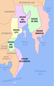
Davao Oriental (Cebuano: Sidlakang Dabaw) is a province in the Philippines located in the Davao Region in Mindanao. Its capital is Mati, and it borders the province of Davao de Oro to the west, and Agusan del Sur and Surigao del Sur to the north. The province is the traditional homeland of the Mandaya and Kagan people.
Davao Oriental | |
|---|---|
| Province of Davao Oriental | |
 Flag  Seal | |
| Etymology: Davao Oriental (i.e., "Eastern Davao") | |
| Nickname(s): | |
| Anthem: Banwa na Madayaw | |
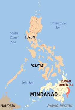 Location in the Philippines | |
| Coordinates: 7°10′N 126°20′E | |
| Country | Philippines |
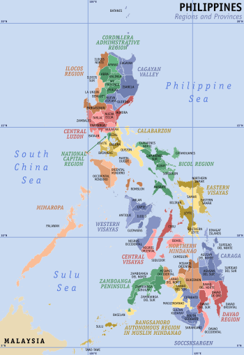
| Region | Davao Region (Region XI) |
| Founded | July 1, 1967 |
| Capital | Mati |
| Government | |
| • Type | Sangguniang Panlalawigan |
| • Governor | Nelson L. Dayanghirang (PDP-Laban) |
| • Vice Governor | Niño Sotero L. Uy Jr. (PDP-Laban) |
| Area | |
| • Total | 5,679.64 km2 (2,192.92 sq mi) |
| Area rank | 14th out of 81 |
| Highest elevation | 1,620 m (5,310 ft) |
| Population (2015 census)[4] | |
| • Total | 558,958 |
| • Rank | 54th out of 81 |
| • Density | 98/km2 (250/sq mi) |
| • Density rank | 70th out of 81 |
| Demonym(s) | Eastern Davaoeño |
| Divisions | |
| • Independent cities | 0 |
| • Component cities | 1
|
| • Municipalities | 10
|
| • Barangays | 183 |
| • Districts | 1st and 2nd districts of Davao Oriental |
| Time zone | UTC+8 (PHT) |
| ZIP code | 8200–8210 |
| IDD : area code | +63 (0)87 |
| ISO 3166 code | PH |
| Spoken languages | |
| Income classification | 1st class |
| Website | www |
Davao Oriental is the easternmost province in the country with Pusan Point in the municipality of Caraga as the easternmost location. The Philippine Sea, part of the Pacific Ocean, faces Davao Oriental to the east. Part of the province lies on an unnamed peninsula that encloses the Davao Gulf to the west.
The province is the top producer of coconut and copra in the country, earning the province the title Coconut Capital of the Philippines.[1][2] It is also home to Mount Hamiguitan Wildlife Sanctuary, a UNESCO World Heritage Site.
Etymology
The name of the province was derived from the word, Dabaw, of which the center was west of the province.
History
Precolonial and Spanish periods
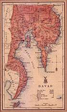
The present territory of Davao Oriental was covered by the historical region of Caraga, which was under the Sultanate of Maguindanao. The Spaniards established a permanent settlement in the region in 1591, and in 1844, the area was ceded by the Sultanate to Spain. An expedition was sent by the colonial government in Manila in 1847 to control the region, led by the Spaniard Jose Oyanguren, who settled in the town of Davao and organized the surrounding areas into the province of Nueva Guipozcoa in 1849. The province existed until 1858, when the politico-military commandancias of Davao and Bislig were created in its place. Bislig was incorporated into the District of Davao two years later.[5]
American period
In 1903, the colonial American government created the Moro Province comprising several districts, one of which was Davao. The Moro province was converted in 1914 into the Department of Mindanao and Sulu, and its component districts were made into independent provinces.[5]
World War II
In 1942, the territory of what is now Davao Oriental was occupied by the Japanese Imperial forces.
In 1945, beginning the Battle of Davao from the combined forces of the British, Australian, Dutch and the Filipino troops of the 6th, 101st, 102nd, 103rd, 104th, 106th, 107th and 110th Infantry Division of the Philippine Commonwealth Army and 10th Infantry Regiment of the Philippine Constabulary was supported by the recognized Davaoeño guerrilla fighter units by the attack to the Japanese Imperial forces during the liberation in Eastern Davao or Eastern Davao Campaign until the end of the Second World War.
Independence
On July 1, 1967, through Republic Act No. 4867, the province of Davao was divided into three independent provinces, one of which was Davao Oriental.[6][5]
Geography
Davao Oriental covers a total area of 5,679.64 square kilometres (2,192.92 sq mi)[7] occupying the eastern tip of the Davao Region in Mindanao. The province is bordered by Davao de Oro to the west, Agusan del Sur and Surigao del Sur to the north, the Davao Gulf to the southwest, and the Philippine Sea to the east and southeast.
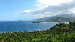
The Eastern Pacific Cordillera mountain range encompasses the province. To the east of the range lie narrow strips of coastal areas, which feature several inlets and bays.[8][9] The province encloses the Davao Gulf to the southwest.
Climate
Davao Oriental has a pronounced rainy season and a short dry season, with maximum rainfall occurring from November to January especially at coastal areas.[5]
| Climate data for Davao Oriental | |||||||||||||
|---|---|---|---|---|---|---|---|---|---|---|---|---|---|
| Month | Jan | Feb | Mar | Apr | May | Jun | Jul | Aug | Sep | Oct | Nov | Dec | Year |
| Average high °C (°F) | 30.5 (86.9) |
31.0 (87.8) |
32.0 (89.6) |
32.8 (91.0) |
32.2 (90.0) |
31.8 (89.2) |
31.3 (88.3) |
31.5 (88.7) |
31.8 (89.2) |
32.3 (90.1) |
31.8 (89.2) |
31.3 (88.3) |
31.7 (89.0) |
| Average low °C (°F) | 23.7 (74.7) |
23.9 (75.0) |
24.1 (75.4) |
24.7 (76.5) |
24.8 (76.6) |
24.6 (76.3) |
24.4 (75.9) |
24.5 (76.1) |
24.4 (75.9) |
24.4 (75.9) |
24.4 (75.9) |
24.2 (75.6) |
24.3 (75.8) |
| Average rainy days | 15 | 11 | 13 | 11 | 15 | 17 | 15 | 14 | 13 | 15 | 15 | 13 | 167 |
| Source: Storm247 [10] | |||||||||||||
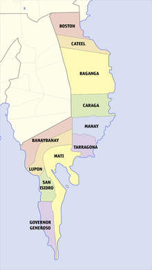
Administrative divisions
Davao Oriental comprises 10 municipalities and 1 city, all organized into 2 legislative districts. There are 183 barangays in the province.
| ||||||||||||||||||||||||||||||||||||||||||||||||||||||||||||||||||||||||||||||||||||||||||||||||||||||||||||||||||||||||||||||||||||||||||||||||||||||||||||||||||||||||||||||||||||||||||||
Demographics
| Population census of Davao Oriental | ||
|---|---|---|
| Year | Pop. | ±% p.a. |
| 1990 | 394,697 | — |
| 1995 | 413,472 | +0.87% |
| 2000 | 446,191 | +1.65% |
| 2007 | 486,104 | +1.19% |
| 2010 | 517,618 | +2.31% |
| 2015 | 558,958 | +1.47% |
| Source: Philippine Statistics Authority[4][11][11] | ||
The population of Davao Oriental in the 2015 census was 558,958 people,[4] with a density of 98 inhabitants per square kilometre or 250 inhabitants per square mile.
The province is mostly inhabited by Cebuanos, who settled the province in the early 20th century from Visayas. Other ethnic groups include the Mandayas, Mansakas, Manobos and the Kagan.[5]
The native (and official) language spoken in the province are Kagan and Mandaya. Cebuano is also spoken, and Chavacano de Davao being spoken by the people from Davao de Oro and Davao City.
Even some of the natives adhere to Christian faith (mostly Catholics), they are syncretic in some of their beliefs. Muslim Kagans traditionally inhabited the plains and coastal areas of the Municipalities of Banaybanay, Lupon, San Isidro, Governor Generoso, Mati and Tarragona.
Economy
Davao Oriental is the top coconut and copra (dried coconut meat) producer in the Philippines.[1] It also is a major producer of abacá, and exports crude oil and copra pellets. [2]
On March 20, 2018, Davao Oriental signed a memorandum of understanding (MOU) with Pionaire Finance Limited, a Hong Kong-based foreign firm for a $27-billion industrial park. [12][13][14][15]
References
- Duallo, Neela (31 July 2009). "1st Mindanao Coconut Summit takes centerstage in coco capital of RP". PIA Archive News Reader. Philippine Information Agency. Archived from the original on 28 March 2016. Retrieved 19 March 2016.
Being the number one coconut producer in the country, the province of Davao Oriental, the local government unit of Mati and the Mindanao Business Council has taken the initiative in addressing the today's plight of the coconut industry, initiate moves to save the industry, and help the coconut farmers so they can hold on, continue to cultivate their land, and bring back the glory of the product that has given both comfort and challenge to the economic lives of the people of the province.
- "Davao Oriental Gov Malanyaon joins GMA in Spain". Mindanao News and Information Cooperative Center. Davao Oriental Information Office. 30 November 2007. Retrieved 19 March 2016.
As the “coconut capital” of the Philippines, Davao Oriental produces one billion nuts annually covering a total crop area of 154,000 hectares. The major products exported by the province through the International Copra Exporter’s Corporation are crude oil and copra pellets. Records show that export of 816,863 metric tons of crude oil and pellets from 1997 to 2001 is valued at $185.7 million. Davao Oriental is also the top producer of abaca fiber in Southern Mindanao. A total of 7,110 hectares is planted to abaca with production volume of 7,500 metric tons. The provincial government says that another 200,000 hectares is being targeted for the expansion of abaca production. Abaca plantations are located in the municipalities of Manay, Baganga, Cateel, Boston, Tarragona, Lupon, Banaybanay and in the City of Mati, the province’s capital. Recently, the province started to plant banana for export particularly in the municipality of Lupon, San Isidro, Governor Generoso and Mati.
- "List of Provinces". PSGC Interactive. Makati City, Philippines: National Statistical Coordination Board. Archived from the original on 11 January 2013. Retrieved 15 April 2014.
- Census of Population (2015). "Region XI (Davao Region)". Total Population by Province, City, Municipality and Barangay. PSA. Retrieved 20 June 2016.
- Lancion, Jr., Conrado M.; cartography by de Guzman, Rey (1995). "The Provinces; Davao Oriental". Fast Facts about Philippine Provinces (The 2000 Millenium ed.). Makati, Metro Manila, Philippines: Tahanan Books. p. 70. ISBN 971-630-037-9. Retrieved 28 April 2016.
- "Republic Act No. 4867 - An Act Creating the Provinces of Davao del Norte, Davao del Sur and Davao Oriental". Chan Robles Virtual Law Library. 8 May 1967. Retrieved 30 January 2016.
- "Province: Davao Oriental". PSGC Interactive. Quezon City, Philippines: Philippine Statistics Authority. Retrieved 8 January 2016.
- Wernstedt, Frederick L.; Spencer, Joseph Earl (1978). The Philippine Island World: A Physical, Cultural, and Regional Geography. Berkeley: University of California Press. pp. 32-37. ISBN 9780520035133. Retrieved 27 January 2016.
- Hinz, Erhard (1985). Human Helminthiases in the Philippines the Epidemiological and Geomedical Situation. Berlin, Heidelberg: Springer Berlin Heidelberg. pp. 129–131. ISBN 9783642708411. Retrieved 27 January 2016.
- "Weather forecast for Davao Oriental, Philippines". Storm247.com. StormGeo AS, Nordre Nøstekaien 1, N-5011 Bergen, Norway: StormGeo AS. Retrieved 28 April 2016.CS1 maint: location (link)
- Census of Population and Housing (2010). "Region XI (Davao Region)". Total Population by Province, City, Municipality and Barangay. NSO. Retrieved 29 June 2016.
- Davao Oriental, Pionaire sign MOU for $27-B industrial park https://www.rappler.com/business/198568-davao-oriental-mou-industrial-park-pionaire
- Residents to benefit from US$27-billion industrial park in Davao - Guv http://pia.gov.ph/news/articles/1006034
- Industrial Park to rise in Davao Oriental http://davaotoday.com/main/economy/industrial-park-to-rise-in-davao-oriental/
- GOV, PARTNERS LEAD HISTORIC GROUNDBREAKING OF DAVAO ORIENTAL INDUSTRIAL PARK http://news.davaooriental.com.ph/index.php/gov-partners-lead-historic-groundbreaking-of-davao-oriental-industrial-park/
External links


- Davao Oriental wants Hamiguitan declared as world heritage site
- Philippine Standard Geographic Code
- News from Davao Oriental
- Davao Oriental Eco Industrial Park
Places adjacent to Davao Oriental | ||||||||||
|---|---|---|---|---|---|---|---|---|---|---|
| ||||||||||
Mati (capital) | |
| Municipalities | |
| Component cities | |