Davao Occidental
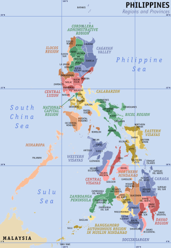
Davao Occidental (Cebuano: Kasadpang Dabaw) is the 81st and newest province in the Philippines located in the Davao Region in Mindanao.[3][4][5] Its capital is the municipality of Malita. To the east lies the Davao Gulf. It also shares a maritime border with the Indonesian province of North Sulawesi to the south.
Davao Occidental | |
|---|---|
| Province of Davao Occidental | |
 Flag  Seal | |
| Etymology: Davao Occidental (i.e., "Western Davao") | |
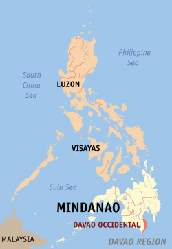 Location in the Philippines | |
| Coordinates: 6°05′N 125°40′E | |
| Country | Philippines |
| Region | Davao Region (Region XI) |
| Founded | 28 October 2013 |
| Capital | Malita |
| Government | |
| • Type | Sangguniang Panlalawigan |
| • Governor | Claude P. Bautista (HNP) |
| • Vice Governor | Franklin P. Bautista (HNP) |
| • Representative | Lorna Bautista-Bandigan |
| Area | |
| • Total | 2,163.45 km2 (835.31 sq mi) |
| Area rank | 57th out of 81 |
| Highest elevation (Mount Latian) | 1,612 m (5,289 ft) |
| Population (2015 census)[2] | |
| • Total | 316,342 |
| • Rank | 65th out of 81 |
| • Density | 150/km2 (380/sq mi) |
| • Density rank | 59th out of 81 |
| Demonym(s) | Western Davaoeño |
| Divisions | |
| • Independent cities | 0 |
| • Component cities | 0 |
| • Municipalities | |
| • Barangays | 105 |
| • Districts | Lone District of Davao Occidental |
| Time zone | UTC+8 (PHT) |
| Spoken languages | |
| Income classification | 4th class |
| Website | davaooccidental |
According to Article IX Section 48 of the provincial charter, the first set of elective officials were elected on May 9, 2016, the next local elections following the foundation of the province.
Creation
Davao Occidental was created through Republic Act 10360 enacted on July 23, 2013, comprising five of the eight municipalities that constitute the 2nd district of Davao del Sur. RA 10360 was passed by the House of Representatives and Senate on November 28, 2012, and December 5, 2012, respectively, and signed by President Benigno Aquino III on January 14, 2013.[3][6] A plebiscite was held on October 28, 2013 along with the barangay elections and the majority of votes cast were "Yes", ratifying the province.[4]
The motive of creating the province was to boost the economic condition and social progress of the municipalities. Senator Ferdinand Marcos Jr., who sponsored the creation of Davao Occidental, said that the distances of Digos, Davao del Sur's provincial capital, to other municipalities in the second Congressional District are far-off that impairs the effective delivery of basic services, as well as the access to government offices.[7] However, Davao del Sur Representative Marc Douglas Cagas considered the creation of the province as nothing more than gerrymandering and political convenience.[8]
Government officials of Davao del Sur with assistance from the Department of Interior and Local Government exercised jurisdiction over the Davao Occidental until the elected local officials of the 2016 elections assumed office.[9][10]
Geography
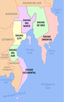
Davao Occidental covers a total area of 2,163.45 square kilometres (835.31 sq mi)[11] occupying the southwestern tip of the Davao Region in Mindanao. The province is bordered on the northwest by Davao del Sur; west by Sarangani and northeast by the Davao Gulf.
The topography of Davao Occidental is hilly, rugged and sloping, with nearly the whole province consisting of mountains. Its eastern shoreline consists of cliffs and beaches with hills immediately on their backs. Coconut trees and hardwood trees mostly dominate the provincial mainland.
Government
The province of Davao Occidental is governed by a governor and a vice governor. The whole province is a lone congressional legislative district.[11] The municipality of Malita, the largest and most populous in the province, serves as the provincial capital and the place where the provincial officials of Davao Occidental convene.
Administrative divisions
The province comprises 5 municipalities.

| Municipality [lower-roman 1] | Population | ±% p.a. | Area[11] | Density | Barangay | |||||||
|---|---|---|---|---|---|---|---|---|---|---|---|---|
| (2015)[2] | (2010)[12] | km2 | sq mi | /km2 | /sq mi | |||||||
| Don Marcelino | 14.1% | 44,554 | 41,942 | +1.16% | 407.30 | 157.26 | 110 | 280 | 15 | |||
| Jose Abad Santos | 24.1% | 76,332 | 69,631 | +1.76% | 600.06 | 231.68 | 130 | 340 | 26 | |||
| Malita | † | 37.2% | 117,746 | 109,568 | +1.38% | 883.37 | 341.07 | 130 | 340 | 30 | ||
| Santa Maria | 17.0% | 53,671 | 49,349 | +1.61% | 175.00 | 67.57 | 310 | 800 | 22 | |||
| Sarangani | 7.6% | 24,039 | 23,290 | +0.60% | 97.72 | 37.73 | 250 | 650 | 12 | |||
| Total | 316,342 | 293,780 | +1.42% | 2,163.45 | 835.31 | 150 | 390 | 105 | ||||
| † Provincial capital | Municipality | |||||||||||
| ||||||||||||
Demographics
The population of Davao Occidental in the 2015 census was 316,342 people,[2] with a density of 150 inhabitants per square kilometre or 390 inhabitants per square mile.
| Population census of Davao Occidental | |||||||||||||||||||||||||
|---|---|---|---|---|---|---|---|---|---|---|---|---|---|---|---|---|---|---|---|---|---|---|---|---|---|
|
| ||||||||||||||||||||||||
Sources:
| |||||||||||||||||||||||||
The population mostly consists of people whose ancestors originate from the migrants from Visayan Islands and Luzon. The Lumad natives only form a small part of the population and live in the more mountainous and forested areas of the province.
Economy

The main industries in Davao Occidental are aquaculture and agriculture. Economic produce in the province include fish, bananas and coconuts which are then exported to several major cities within southern Mindanao, including Davao City. Rice farms are only limited to the few flat lands in the province due to its mountainous and thickly forested nature.
The capital town of Malita is the province's main commercial hub.
Tourism has started to gain traction in the province, with potential tourist destinations mostly concentrated at the province's coastal beaches and the Sarangani and Balut islands in the south.[14]
Transportation
Davao Occidental is served by only one partially-coastal highway that traverses the whole length of the provincial mainland from north to south, and could only be accessed by going through the road crossings in Sulop in Davao del Sur province and, farther ahead, in the city of General Santos. Buses, jeepneys and passenger vans that originate from and serve the cities of Davao and Digos are the main primary modes of transportation in the province. Boats serve as the primary maritime mode of transportation for coastal areas not yet accessible by roads and the island municipality of Sarangani.
References
- "Province: Davao Occidental". PSGC Interactive. Makati City, Philippines: National Statistical Coordination Board. Archived from the original on 16 April 2014. Retrieved 15 April 2014.
- Census of Population (2015). "Region XI (Davao Region)". Total Population by Province, City, Municipality and Barangay. PSA. Retrieved 20 June 2016.
- "Republic Act No. 10360; An Act Creating the Province of Davao Occidental". Official Gazette of the Republic of the Philippines. Metro Manila, Philippines: Congress of the Philippines. 14 January 2013. Retrieved 24 July 2016.
- Cayon, Carina L. (30 October 2013). "DavSur voters approve of Davao Occidental". Philippine Information Agency. Archived from the original on 3 December 2013. Retrieved 7 November 2013.
- "Davao Occidental, PH's 81st province". Manila Bulletin. Yahoo! News Philippines. 31 October 2013. Archived from the original on 4 November 2013. Retrieved 24 July 2016.
- "COMELEC to conduct plebiscite for the creation of Davao Occidental". Official Gazette. COMELEC. September 18, 2013. Retrieved 7 November 2013.
- "Davao Occidental Province Soon To Be Realized". Senate of the Philippines. May 16, 2012. Archived from the original on 28 September 2013. Retrieved 7 November 2013.
- Regalado, Edith (January 24, 2013). "'Creation of Davao Occidental just for political convenience'". philSTAR.com. Retrieved 7 November 2013.
- Carillo, C.A. (10 November 2013). "Davao Occidental province to be created". BusinessWorld. Retrieved 27 January 2016.
- "Plebiscite results favor new Davao province". Philippine Daily Inquirer. 30 October 2013. Retrieved 27 January 2016.
- "Province: Davao Occidental". PSGC Interactive. Quezon City, Philippines: Philippine Statistics Authority. Retrieved 8 January 2016.
- Census of Population and Housing (2010). "Region XI (Davao Region)". Total Population by Province, City, Municipality and Barangay. NSO. Retrieved 29 June 2016.
- Censuses of Population (1903–2007). "Region XI (Davao Region)". Table 1. Population Enumerated in Various Censuses by Province/Highly Urbanized City: 1903 to 2007. NSO.
- Top 10 Must Visit Attractions in Davao Occidental
External links


- Republic Act No. 10360: "Charter of the Province of Davao Occidental"
Places adjacent to Davao Occidental | ||||||||||
|---|---|---|---|---|---|---|---|---|---|---|
| ||||||||||
Malita (capital) | |
| Municipalities | |