Patnongon
Patnongon, officially the Municipality of Patnongon, (Kinaray-a: Banwa kang Patnongon; Hiligaynon: Banwa sang Patnongon; Tagalog: Bayan ng Patnongon), is a 3rd class municipality in the province of Antique, Philippines. According to the 2015 census, it has a population of 37,176 people.[4]
Patnongon | |
|---|---|
| Municipality of Patnongon | |
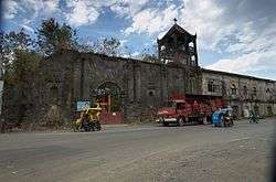 Patnongon Church | |
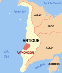 Map of Antique with Patnongon highlighted | |
OpenStreetMap 
| |
.svg.png) Patnongon Location within the Philippines | |
| Coordinates: 10°55′N 121°59′E | |
| Country | |
| Region | Western Visayas (Region VI) |
| Province | Antique |
| District | Lone district |
| Barangays | 36 (see Barangays) |
| Government | |
| • Type | Sangguniang Bayan |
| • Mayor | Evohn Nee B. Baldestamon |
| • Vice Mayor | Johnnyflores S. Bacongallo |
| • Congressman | Loren Legarda |
| • Electorate | 21,912 voters (2019) |
| Area | |
| • Total | 167.92 km2 (64.83 sq mi) |
| Elevation | 15.4 m (50.5 ft) |
| Population (2015 census)[4] | |
| • Total | 37,176 |
| • Density | 220/km2 (570/sq mi) |
| • Households | 8,540 |
| Economy | |
| • Income class | 3rd municipal income class |
| • Poverty incidence | 22.29% (2015)[5] |
| • Revenue (₱) | 103,319,998.35 (2016) |
| Time zone | UTC+8 (PST) |
| ZIP code | 5702 |
| PSGC | |
| IDD : area code | +63 (0)36 |
| Climate type | tropical climate |
| Native languages | Kinaray-a language Hiligaynon Tagalog |
| Website | elgu |
Geography
Patnongon is located at 10°55′N 121°59′E. It is 25 kilometres (16 mi) from the provincial capital, San Jose de Buenavista.
According to the Philippine Statistics Authority, the municipality has a land area of 167.92 square kilometres (64.83 sq mi) [2] constituting 6.15% of the 2,729.17-square-kilometre- (1,053.74 sq mi) total area of Antique.
Climate
| Climate data for Patnongon, Antique | |||||||||||||
|---|---|---|---|---|---|---|---|---|---|---|---|---|---|
| Month | Jan | Feb | Mar | Apr | May | Jun | Jul | Aug | Sep | Oct | Nov | Dec | Year |
| Average high °C (°F) | 30 (86) |
31 (88) |
32 (90) |
33 (91) |
32 (90) |
30 (86) |
29 (84) |
29 (84) |
29 (84) |
29 (84) |
30 (86) |
30 (86) |
30 (87) |
| Average low °C (°F) | 22 (72) |
22 (72) |
22 (72) |
24 (75) |
25 (77) |
25 (77) |
25 (77) |
25 (77) |
25 (77) |
24 (75) |
23 (73) |
22 (72) |
24 (75) |
| Average precipitation mm (inches) | 48 (1.9) |
41 (1.6) |
58 (2.3) |
82 (3.2) |
223 (8.8) |
300 (11.8) |
346 (13.6) |
307 (12.1) |
311 (12.2) |
292 (11.5) |
167 (6.6) |
81 (3.2) |
2,256 (88.8) |
| Average rainy days | 11.4 | 7.7 | 11.3 | 15.4 | 25.7 | 28.5 | 29.5 | 28.7 | 28.3 | 28.7 | 21.8 | 15.2 | 252.2 |
| Source: Meteoblue [6] | |||||||||||||
Barangays
Patnongon is politically subdivided into 36 barangays.[7]
| PSGC | Barangay | Population | ±% p.a. | |||
|---|---|---|---|---|---|---|
| 2015[4] | 2010[8] | |||||
| 060612001 | Alvañiz | 0.7% | 257 | 212 | 3.73% | |
| 060612002 | Amparo | 2.0% | 725 | 676 | 1.34% | |
| 060612003 | Apgahan | 4.5% | 1,671 | 1,573 | 1.16% | |
| 060612004 | Aureliana | 6.9% | 2,551 | 2,272 | 2.23% | |
| 060612005 | Badiangan | 2.0% | 725 | 685 | 1.09% | |
| 060612006 | Bernaldo A. Julagting (Bitas) | 2.1% | 786 | 749 | 0.92% | |
| 060612007 | Carit-an | 5.4% | 2,018 | 1,912 | 1.03% | |
| 060612008 | Cuyapiao | 2.8% | 1,050 | 1,020 | 0.55% | |
| 060612010 | Gella | 1.1% | 416 | 388 | 1.34% | |
| 060612011 | Igbarawan | 4.2% | 1,565 | 1,418 | 1.90% | |
| 060612012 | Igbobon | 2.0% | 742 | 597 | 4.23% | |
| 060612013 | Igburi | 3.4% | 1,260 | 998 | 4.54% | |
| 060612014 | La Rioja | 6.1% | 2,278 | 2,266 | 0.10% | |
| 060612015 | Mabasa | 3.1% | 1,151 | 1,032 | 2.10% | |
| 060612016 | Macarina | 1.9% | 689 | 659 | 0.85% | |
| 060612017 | Magarang | 1.2% | 441 | 355 | 4.22% | |
| 060612018 | Magsaysay | 4.1% | 1,533 | 1,457 | 0.97% | |
| 060612019 | Padang | 4.5% | 1,663 | 1,576 | 1.03% | |
| 060612020 | Pandanan | 2.6% | 953 | 911 | 0.86% | |
| 060612021 | Patlabawon | 1.3% | 494 | 453 | 1.66% | |
| 060612022 | Poblacion | 16.3% | 6,044 | 5,701 | 1.12% | |
| 060612023 | Quezon | 0.9% | 346 | 314 | 1.86% | |
| 060612024 | Salaguiawan | 1.4% | 539 | 468 | 2.73% | |
| 060612025 | Samalague | 2.6% | 970 | 1,541 | −8.44% | |
| 060612026 | San Rafael | 2.2% | 829 | 803 | 0.61% | |
| 060612028 | Tamayoc | 3.6% | 1,330 | 1,304 | 0.38% | |
| 060612029 | Tigbalogo | 1.5% | 570 | 541 | 1.00% | |
| 060612027 | Tobias Fornier | 1.2% | 441 | 411 | 1.35% | |
| 060612030 | Villa Crespo | 1.2% | 463 | 413 | 2.20% | |
| 060612031 | Villa Cruz | 1.5% | 543 | 446 | 3.82% | |
| 060612009 | Villa Elio | 1.2% | 429 | 386 | 2.03% | |
| 060612032 | Villa Flores | 0.5% | 191 | 175 | 1.68% | |
| 060612033 | Villa Laua-an | 0.9% | 340 | 306 | 2.03% | |
| 060612034 | Villa Sal | 0.7% | 271 | 236 | 2.67% | |
| 060612035 | Villa Salomon | 1.1% | 423 | 390 | 1.56% | |
| 060612036 | Vista Alegre | 1.3% | 479 | 458 | 0.86% | |
| Total | 37,176 | 35,102 | 1.10% | |||
Demographics
| Population census of Patnongon | ||
|---|---|---|
| Year | Pop. | ±% p.a. |
| 1903 | 14,319 | — |
| 1918 | 15,721 | +0.62% |
| 1939 | 20,012 | +1.16% |
| 1948 | 23,145 | +1.63% |
| 1960 | 23,207 | +0.02% |
| 1970 | 22,443 | −0.33% |
| 1975 | 22,643 | +0.18% |
| 1980 | 24,262 | +1.39% |
| 1990 | 27,376 | +1.22% |
| 1995 | 29,235 | +1.24% |
| 2000 | 31,555 | +1.65% |
| 2007 | 33,694 | +0.91% |
| 2010 | 35,102 | +1.50% |
| 2015 | 37,176 | +1.10% |
| Source: Philippine Statistics Authority[4][8][9][10] | ||
In the 2015 census, Patnongon had a population of 37,176.[4] The population density was 220 inhabitants per square kilometre (570/sq mi).
Patnonganons speak Kinaray-a as their main dialect while Hiligaynon is used as their secondary dialect.
Attractions
- Amihan Beach Resort in La Rioja
- La Parola Orchids Beach Resort in Barangay Amparo
- Igbarawan Garden Resort in Igbarawan
- Bato-Bugtong Beach and resort in Igbarawan
- D'Viking Beach Resort in Igbarawan
- Apgahan Beach Resort / San Ramon Beach Resort
- Bato Tibi of Tamayoc
- Villa Alma Beach Resort in Padang
- Mountain Climbing in small mountains near Padang, Apgahan, Aureliana, La-Rioja and Aureliana where one can find fruit‑bearing wild trees
- Old Municipal Building Constructed by Spaniards
- Old Spanish Church Convent now Saint Augustine's Academy of Patnongon, Inc. old building (It is believed that if it was not bombed by the Americans during World War II, the Patnongon Church would have been the biggest in Antique Province and one of the oldest churches in the Philippines.)
- Spelunking in Kuweba Dapa and Kuweba Turu-ong in Barangay San Rafael
- Shrine of Rosa Mystica in Tigmanali
- Linaw-Balud Falls in Barangay Igburi
- Lipunto Range in Barangay Patlabawon
- Ulo Kuliatan and Busay Luhot in Aureliana, Patnongon, Antique
- Guinobatan Mountain at the boundary of Belison and Aureliana
- Madlakat Cliff in the Boundary of San Remegio, Sibalom, Patlabawon and Aureliana
References
- "Municipality". Quezon City, Philippines: Department of the Interior and Local Government. Retrieved 31 May 2013.
- "Province: Antique". PSGC Interactive. Quezon City, Philippines: Philippine Statistics Authority. Retrieved 12 November 2016.
- "Patnongon, Antique Profile". PhilAtlas.com. Retrieved 15 June 2020.
- Census of Population (2015). "Region VI (Western Visayas)". Total Population by Province, City, Municipality and Barangay. PSA. Retrieved 20 June 2016.
- "PSA releases the 2015 Municipal and City Level Poverty Estimates". Quezon City, Philippines. Retrieved 12 October 2019.
- "Patnongon: Average Temperatures and Rainfall". Meteoblue. Retrieved 1 May 2020.
- "Municipal: Patnongon". PSGC Interactive. Quezon City, Philippines: Philippine Statistics Authority. Retrieved 8 January 2016.
- Census of Population and Housing (2010). "Region VI (Western Visayas)". Total Population by Province, City, Municipality and Barangay. NSO. Retrieved 29 June 2016.
- Censuses of Population (1903–2007). "Region VI (Western Visayas)". Table 1. Population Enumerated in Various Censuses by Province/Highly Urbanized City: 1903 to 2007. NSO.
- "Province of Antique". Municipality Population Data. Local Water Utilities Administration Research Division. Retrieved 17 December 2016.
External links
Places adjacent to Patnongon | ||||||||||
|---|---|---|---|---|---|---|---|---|---|---|
| ||||||||||