San Dionisio, Iloilo
San Dionisio, officially the Municipality of San Dionisio, (Hiligaynon: Banwa sang San Dionisio, Tagalog: Bayan ng San Dionisio), is a 4th class municipality in the province of Iloilo, Philippines. According to the 2015 census, it has a population of 38,775 people.[3]
San Dionisio | |
|---|---|
| Municipality of San Dionisio | |
 View of San Dionisio from east from Mount Opao on Sicogon island | |
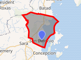
 Map of Iloilo with San Dionisio highlighted | |
| |
.svg.png) San Dionisio Location within the Philippines | |
| Coordinates: 11°16′16″N 123°05′41″E | |
| Country | |
| Region | Western Visayas (Region VI) |
| Province | Iloilo |
| District | 5th district of Iloilo |
| Barangays | 29 (see Barangays) |
| Government | |
| • Type | Sangguniang Bayan |
| • Mayor | Larry C. Villanueva |
| • Vice Mayor | Darwin E. Bajada |
| • Congressman | Raul C. Tupas |
| • Electorate | 24,605 voters (2019) |
| Area | |
| • Total | 127.06 km2 (49.06 sq mi) |
| Elevation | 23.3 m (76.4 ft) |
| Population (2015 census)[3] | |
| • Total | 38,775 |
| • Density | 310/km2 (790/sq mi) |
| • Households | 8,961 |
| Economy | |
| • Income class | 4th municipal income class |
| • Poverty incidence | 28.16% (2015)[4] |
| • Revenue (₱) | 89,934,061.87 (2016) |
| Time zone | UTC+8 (PST) |
| ZIP code | 5015 |
| PSGC | |
| IDD : area code | +63 (0)33 |
| Climate type | tropical climate |
| Native languages | Hiligaynon Capiznon Tagalog |
| Website | www |
San Dionisio is 106 kilometres (66 mi) from Iloilo City and is 91 kilometres (57 mi) from Roxas City. Quiniluban Island, Tago Island and Igbon Island, known for coral reef scuba diving and ecotourism, lie in the east across the Concepcion bay.
History
During the Spanish Colonization of Philippines, a native leader named "Dionisio" had cleared the forest land to create a settlement called "Lakdayan". In 1877 Spanish arrived and renamed "Lakdayan" to "Dionisio" in the honor of humble fisherman founder of the settlement. Spanish converted the natives and appointed St. Vincent Ferrer as Patron Saint of the settlement. Spanish set up the municipality at Concepcion, of which Dioniso was a part of. During Spanish times, the head of the local government of Concepcion was titled "Kapitan" (captain) and the subordinate leaders in San Dionisio were titled "Tenientes" (lieutenant) and hereditary Cabeza de Barangay (head of barangay). Eventually Sara was carved out of Concepcion to establish an eponymous municipality, which also included Dionisio as one of the constituent barangay of Sara. In 1920, San Dionisio municipality was established after carving it out of Sara municipality.
Climate
San Dionisio has intermediate tropical climate, relatively dry from December to April and wet for the rest of the year. Northeast monsoon and trade winds cause the dry and sunny weather. Southeast monsoons and cyclone storms cause the wet and stormy conditions. January is the coldest month during the relatively cool tropical period from December to February. April to June summer season has the warmest temperature. High tropical temperature and the sea on eastern side cause the high relative humidity.
| Climate data for San Dionisio, Iloilo | |||||||||||||
|---|---|---|---|---|---|---|---|---|---|---|---|---|---|
| Month | Jan | Feb | Mar | Apr | May | Jun | Jul | Aug | Sep | Oct | Nov | Dec | Year |
| Average high °C (°F) | 27 (81) |
28 (82) |
29 (84) |
31 (88) |
32 (90) |
31 (88) |
30 (86) |
30 (86) |
29 (84) |
29 (84) |
29 (84) |
27 (81) |
29 (85) |
| Average low °C (°F) | 23 (73) |
23 (73) |
23 (73) |
24 (75) |
25 (77) |
25 (77) |
24 (75) |
24 (75) |
24 (75) |
24 (75) |
24 (75) |
23 (73) |
24 (75) |
| Average precipitation mm (inches) | 61 (2.4) |
39 (1.5) |
46 (1.8) |
48 (1.9) |
90 (3.5) |
144 (5.7) |
152 (6.0) |
145 (5.7) |
163 (6.4) |
160 (6.3) |
120 (4.7) |
90 (3.5) |
1,258 (49.4) |
| Average rainy days | 12.3 | 9.0 | 9.9 | 10.0 | 18.5 | 25.0 | 27.4 | 26.0 | 25.9 | 24.9 | 17.9 | 14.2 | 221 |
| Source: Meteoblue [5] | |||||||||||||
Demographics
| Population census of San Dionisio | ||
|---|---|---|
| Year | Pop. | ±% p.a. |
| 1903 | 4,808 | — |
| 1939 | 9,975 | +2.05% |
| 1948 | 11,008 | +1.10% |
| 1960 | 12,690 | +1.19% |
| 1970 | 15,456 | +1.99% |
| 1975 | 16,914 | +1.82% |
| 1980 | 19,410 | +2.79% |
| 1990 | 23,910 | +2.11% |
| 1995 | 25,263 | +1.04% |
| 2000 | 28,702 | +2.77% |
| 2007 | 32,171 | +1.59% |
| 2010 | 33,650 | +1.65% |
| 2015 | 38,775 | +2.74% |
| Source: Philippine Statistics Authority[3][6][7][8] | ||
In the 2015 census, the population of San Dionisio, Iloilo, was 38,775 people,[3] with a density of 310 inhabitants per square kilometre or 800 inhabitants per square mile.
External links
References
- "Municipality". Quezon City, Philippines: Department of the Interior and Local Government. Retrieved 31 May 2013.
- "Province: Iloilo". PSGC Interactive. Quezon City, Philippines: Philippine Statistics Authority. Retrieved 12 November 2016.
- Census of Population (2015). "Region VI (Western Visayas)". Total Population by Province, City, Municipality and Barangay. PSA. Retrieved 20 June 2016.
- "PSA releases the 2015 Municipal and City Level Poverty Estimates". Quezon City, Philippines. Retrieved 12 October 2019.
- "San Dionisio: Average Temperatures and Rainfall". Meteoblue. Retrieved 3 May 2020.
- Census of Population and Housing (2010). "Region VI (Western Visayas)". Total Population by Province, City, Municipality and Barangay. NSO. Retrieved 29 June 2016.
- Censuses of Population (1903–2007). "Region VI (Western Visayas)". Table 1. Population Enumerated in Various Censuses by Province/Highly Urbanized City: 1903 to 2007. NSO.
- "Province of Iloilo". Municipality Population Data. Local Water Utilities Administration Research Division. Retrieved 17 December 2016.
Places adjacent to San Dionisio, Iloilo | ||||||||||
|---|---|---|---|---|---|---|---|---|---|---|
| ||||||||||
Iloilo City (capital) | |
| Municipalities |
|
| Component city | |
| Highly urbanized city |
|