Katepwa
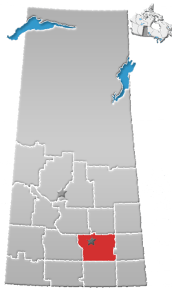
Katepwa (2016 population: 312) is a resort village in the Canadian province of Saskatchewan within Census Division No. 6. It is on the shores of Katepwa Lake in the Rural Municipality of Abernethy No. 186.
Katepwa | |
|---|---|
| Resort Village of the District of Katepwa | |
 Katepwa Beach | |
 Katepwa | |
| Coordinates: 50.7°N 103.634°W[1] | |
| Country | Canada |
| Province | Saskatchewan |
| Census division | 6 |
| Rural municipality | RM of Abernethy No. 186 |
| Incorporated[2] | July 24, 2004 |
| Government | |
| • Mayor | Don Jewitt |
| • Governing body | Resort Village Council |
| • Administrator | Gail E. Sloan |
| Area (2016)[4] | |
| • Land | 5.78 km2 (2.23 sq mi) |
| Population (2016)[4] | |
| • Total | 312 |
| • Density | 54/km2 (140/sq mi) |
| Time zone | CST |
| • Summer (DST) | CST |
| Area code(s) | 306 and 639 |
| Waterway(s) | Katepwa Lake |
History
The Resort Village of the District of Katepwa was incorporated on July 24, 2004.[2] Its incorporation was the result of the amalgamation of three separate resort villages – Katepwa Beach, Katepwa South and Sandy Beach.[5] Katepwa Beach and Katepwa South originally incorporated as a resort villages on August 1, 1957 and January 1, 1990 respectively.[6][7]
- Historical sites
Historical sites in the vicinity of Katepwa include the Motherwell Homestead and the Abernethy Historical Museum.[8]
Beginnings
The Qu'Appelle Valley was formed approximately 14,000 years ago as retreating glaciers and their meltwater sculpted the landscape. The valley was further changed by erosion and sediment. This sediment is also responsible for forming what was once one long lake into the four Fishing Lakes of Pasqua Lake, Echo Lake, Mission Lake, and Katepwa Lake.[9]
Native peoples could have been living in this area as early as eleven thousand years ago, after the glacier retreated. When white settlers reached the area, Assiniboine and Cree were the two most prominent groups living there. Predating the settlers were missions established by Presbyterians, Anglicans and Methodists. In 1864, Fort Qu'Appelle was established as a Hudson Bay Trading Post, and the following year, Bishop Tache, the Bishop of St. Boniface opened a mission at St. Florent, (present day Lebret). Following the first Riel uprising in Manitoba in 1870, Metis were forced to leave the new province and moved into the valley. The first settlers, among them John Louder, began farming in the area soon after. Churches and schools were well established by 1890.[10]
The name likely comes from the Cree word Kahtapwao meaning "What is calling?" The name was given to the last in the chain of four lakes, Katepwa Lake. Legend has it that spirits inhabited the shores of the lake and First Nation people would hear voices on the lake.
Settlement
In 1898, Arthur Osment moved his brick factory from Indian Head to Lebret, but it was not successful, and sold to Clem Peltier who moved it to the end of the lake. The factory was closed by 1908 due to competition.
Soon, activities began happening on the lake, such as picnics, boating, and fishing. A summer resort was soon added to the lake. Skating became a popular winter pastime, as well as ice fishing. A type of net called a jigger which would be placed through a hole in the ice and checked for fish every two days or so. Some commercial fishing took place on Katepwa Lake in the early 1970s.[11]
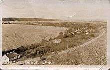
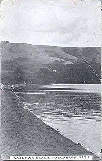
Katepwa Beach Syndicate
By 1914, the Katepwa Beach Syndicate was formed, subdividing the land where the Village of Katepwa now stands. The street names in use as early as 1911 are still in use today, such as Qu’Appelle Avenue and Cypress Street. The syndicate set up laws concerning the sale of property and sanitation in the townsite. Another subdivision, Who Calls Beach, was surveyed in 1911, followed by Lakeview Beach in 1913, Idylwyld in 1919, and Como Park in 1921 (incorporated with Sandy Beach in 1980). Dundurn Park predates the syndicate and the other subdivisions.
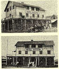
Soon after the syndicate was formed, the summer resort grew to include the hotel, dining room, tea room that also served as a sort of general store, a dance hall, a boat rental, and an 18-hole golf course. The hotel was operated by the Grant family until 1934. In 1940, Jack Obleman and Wally Wirth took over the Katepwa Hotel when the previous owner, Mr. Arlet, died after running the Hotel for a year. Mr. Obleman ran the hotel while Mr. Wirth went overseas in World War II, and Mr. Wirth and his wife, Lillian, ran the Hotel until 1955, at which point they sold it to Allan Robinson from Indian Head. The hotel burned down in May 1977 and was quickly rebuilt, opening July 1 that same year.
In 1912, Adelaide Hemstreet opened the Sunset Inn Tea Room. In 1913 she built a number of simply furnished cabins which she rented to guests. She expanded the land in 1914 and built a kitchen and screened-in veranda. Guests were fed in the tea room, which became exclusive and gave the Inn a very good reputation. Al Chaffee bought the Sunset Inn in 1939 and added a confectionery store and improved the kitchen. He added electric lights to the cabins, the store, the inn, and the dining room, as well as a telephone.
The business was sold in 1946 to W.J. (Bill) Oliver, who expanded the store considerably, increased the number of cabins, modernised the cabins, including electric refrigerators and flush toilets. His wife, Mae, ran the dining room, which offered formal Sunday turkey dinners, and his son, Dwight, helped out as well. Bert Miles bought the store from Bill in 1962, but sold it to Dwight Oliver in 1968. Jay and Bonnie Haaland ran the store from 1970 to 1973, followed by Pete and Frankie Law from 1974 to 1976. Dwight Oliver's children, Bryan and Barbie, ran the business in 1977. The Laws bought the store in 1978 and continued to run the business until 1982, when it was sold to Maureen Barth.
Bill Oliver continued to care for the cabins until the last of them was sold in 1978, leaving only the store. After several more changes in ownership, the store was torn down in April 2010.[12]
Geography
The Resort Village of Katepwa is located approximately 95 km north east of Regina via the Trans-Canada Highway and 120 km south west of Yorkton. The south-facing beach is protected from winds and algae blooms.[13]
Climate
Note: These statistics are for Fort Qu'Appelle in the Qu'Appelle Valley.[14]
- Temperature (Celsius)
| January | February | March | April | May | June | July | August | September | October | November | December | |
|---|---|---|---|---|---|---|---|---|---|---|---|---|
| Average | -16.2 | -12.3 | -5.4 | 4 | 11.4 | 16.1 | 18.4 | 17.5 | 11.4 | 4.6 | -5.4 | -13.3 |
| Average High | -10.8 | -7 | -0.2 | 10.5 | 18.2 | 22.6 | 25 | 24.5 | 17.9 | 10.8 | -0.6 | -8.1 |
| Average Low | -21.5 | -17.5 | -10.6 | -2.4 | 4.5 | 9.7 | 11.7 | 10.5 | 4.8 | -1.7 | -10.1 | -18.5 |
- Precipitation
| January | February | March | April | May | June | July | August | September | October | November | December | |
|---|---|---|---|---|---|---|---|---|---|---|---|---|
| Monthly Rainfall (mm) | 0 | 0 | 6 | 16 | 53 | 79 | 67 | 53 | 40 | 18 | 3 | 1 |
| Monthly Snowfall (cm) | 22 | 18 | 20 | 9 | 3 | 0 | 0 | 0 | 2 | 7 | 16 | 29 |
| Monthly Precipitation (mm) | 20 | 16 | 24 | 25 | 56 | 79 | 67 | 53 | 41 | 24 | 17 | 25 |
Demographics
In the 2016 Census of Population conducted by Statistics Canada, the Resort Village of the District of Katepwa recorded a population of 312 living in 159 of its 808 total private dwellings, a -22.6% change from its 2011 population of 403. With a land area of 5.78 km2 (2.23 sq mi), it had a population density of 54.0/km2 (139.8/sq mi) in 2016.[4]
In the 2011 Census of Population, the Resort Village of the District of Katepwa recorded a population of 403, a 41.4% change from its 2006 population of 285. With a land area of 5.78 km2 (2.23 sq mi), it had a population density of 69.7/km2 (180.6/sq mi) in 2011.[17]
Attractions
Located in the Qu’Appelle Valley, the resort village is home to a hotel and restaurant, cottages and log cabins to rent, and a general store just off the beach, complete with a café, ice cream, and gas and propane. The adjacent beach and provincial park at Katepwa Point feature a playground and a boat launch. The provincial park was formerly Vidal Point Dominion Park from 1921 to 1930.[18]
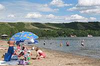
The beach
The beach at Katepwa Point Provincial Park is a perfect swimming spot for cottage-owners and day visitors. Swimming lessons are available for most of the summer, given by certified instructors. A large grassy area just behind the beach boasts mature trees, shading numerous picnic spots and a playground. There one can find restrooms, change rooms, and barbecues. A boat launch can be found east of the beach with a parking lot behind it. There is one dock with two launching pads. Visitors and residents alike participate in many activities on the lake, such as fishing, water-skiing, wakeboarding, tubing, sailing, windsurfing, and many more. Mini-golf is also available, as well as flea markets on Sundays.[19]
Fishing
Fishing is a year-round activity on Katepwa Lake. Perch, walleye, and northern pike are all common fish to be caught, summer and winter. In summertime, fishermen can be seen casting their lines off of the western point, next to the beach. Still others take their boats out for hours on end. In the winter, ice shack villages spring up across the ice, criss-crossed with roads of pick-up truck tire tracks. Record-breaking catches have been recorded on Katepwa Lake for decades.[20]
Golfing
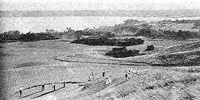
The Katepwa Beach Golf Course has its roots in the Syndicate formed in the early 1900s. Early residents carved the first 18-hole course out of the hills shortly after establishing cottages on the lake. In the eighties, use of the golf course had dropped so low that it was put up for sale, but a group of golfers bought the land, to be reserved for a golf course. In the mid-nineties, a new 9-hole course was built, which has gained international renown. The course is unique in that there is no fee to maintain membership; members need only pay for the rounds of golf they play. A simpler 9-hole, family-friendly course is also located in the area.[21]
Trails
The Katepwa Nature Trail starts in the park and winds through the nearby coulees, with signs along the way explaining flora and fauna that can be found in the area. The Fort Ellis Trail begins at the end of Lake Katepwa and is a day-long driving trip through to Crooked Lake. Bird-watching in Skinners Marsh and a visit to the Fort Ellis Historical Site are possible activities along the way.[22]
Churches

The All Saints’ Anglican Church Katepwe was built in 1886 on the southeastern shore of the lake, in a small settlement then known as Lauder's Town. John Lauder, the owner of the townsite, donated the land. Construction started in July 1886 with the hauling of stones from nearby fields, to be used for the foundation. The main structure is wood and concrete. The church was not fully completed until after its consecration on August 21, 1887. Although the church was not completed until 1887, the members of its congregation held Anglican services in local homes and the schoolhouse as early as 1884, and this is considered the year of origin for All Saints’ Anglican Church Katepwe. The graveyard beside the church is the final resting place of many original settlers. Regular services ceased in 1945 and the church was only used in July and August. By the 60s the building was in poor condition, leaning from the pressure of the chimney. The exterior was repaired, followed by a complete refurbishment of the interior by the end of the 70s. Electricity was installed in 1982. Congregation members throughout the years have made maintenance of the church and churchyard possible by various donations and bequests.
Roman Catholic churches in the area have always centred on Lebret. Catholic interment continues there today.[23]
Government
The Resort Village of the District of Katepwa is governed by an elected municipal council and an appointed administrator that meets on the third Tuesday of every month.[3] The mayor is Don Jewitt while its administrator is Gail E. Sloan.[3] It holds elections once every four years. Anyone who is an eligible voter in his or her municipality can run for a position on council. Eligible voters are those who are over eighteen years of age, reside in Katepwa, and own assessable land in the municipality. Council is responsible for monitoring public funds, appointing the administration, and acting as the internal control for proper use of the public funds. The administration does most of the financial work along with the council within the municipality.[24]
See also
References
- "Download Geographical Names Data: Files to download by province and territory (Saskatchewan, CSV)". Government of Canada. April 8, 2020. Retrieved May 29, 2020.
- "Urban Municipality Incorporations". Saskatchewan Ministry of Government Relations. Archived from the original on October 15, 2014. Retrieved May 26, 2020.
- "Municipality Details: Resort Villlage of Katepwa". Government of Saskatchewan. Retrieved May 28, 2020.
- "Population and dwelling counts, for Canada, provinces and territories, and census subdivisions (municipalities), 2016 and 2011 censuses – 100% data (Saskatchewan)". Statistics Canada. February 8, 2017. Retrieved May 26, 2020.
- "Interim List of Changes to Municipal Boundaries, Status, and Names: From January 2, 2001 to January 1, 2006 (Table 1: Changes to census subdivisions in alphabetical order, by province/territory [Saskatchewan])". Statistics Canada. June 2007. Retrieved June 6, 2020.
- "The Saskatchewan Gazette". Government of Saskatchewan: The Queen's Printer. June 5, 1992. p. 723. Retrieved June 7, 2020.
- "Interim List of Changes to Municipal Boundaries, Status and Names: July 1988 to January 1990 (Table 1: Changes to census subdivisions in alphabetical order, by province/territory [Saskatchewan])". Statistics Canada. January 1990. p. 48. Retrieved June 6, 2020.
- "Activities". Archived from the original on October 10, 2007. Retrieved July 28, 2010.
- "Lake Katepwa Yesterday and Today". Copyright 1984.
- "Lake Katepwa Yesterday and Today". Copyright 1984.
- http://www.wdmprairiegamble.com/story/display_story.php?long_story=yes&mode=&search_keyword=&story_types=1,1,1,1,1,1,1&story_topics=1,1,1,1,1,1,1,1,1,1,1,1&story_time_frames=1,1,1,1,1,1,1,1,1,1,1,1,1,1&story_id=64&PHPSESSID=96208c1f027aef945ddfe7b231e73d55
- http://www.theweathernetwork.com/statistics/CL4013480/cask0104?ref=topnav_weather_statistics
- "Saskatchewan Census Population" (PDF). Saskatchewan Bureau of Statistics. Archived from the original (PDF) on September 24, 2015. Retrieved May 26, 2020.
- "Saskatchewan Census Population". Saskatchewan Bureau of Statistics. Retrieved May 26, 2020.
- "Population and dwelling counts, for Canada, provinces and territories, and census subdivisions (municipalities), 2011 and 2006 censuses (Saskatchewan)". Statistics Canada. June 3, 2019. Retrieved May 26, 2020.
- http://www.saskparks.net/Default.aspx?DN=929e5bec-2c36-42be-b927-379334bf8b2b&subDN=79d55e64-69aa-440b-ae86-35336a783e23
- http://www.tpcs.gov.sk.ca/KatepwaPoint
- http://www.tpcs.gov.sk.ca/KatepwaPoint
- "Archived copy". Archived from the original on July 11, 2011. Retrieved July 28, 2010.CS1 maint: archived copy as title (link)
- "Archived copy". Archived from the original on October 10, 2007. Retrieved July 28, 2010.CS1 maint: archived copy as title (link)
- A Joint Commermoration of The Heritage of All Saints' Anglican Church and of The Career of Archbishop G.F.C. Jackson. Brochure, August 18, 1985.
- "Archived copy". Archived from the original on February 25, 2012. Retrieved July 28, 2010.CS1 maint: archived copy as title (link)
External links
| Wikimedia Commons has media related to Katepwa. |