Pillsbury, North Dakota
Pillsbury is a city in Barnes County, North Dakota, United States. The population was 12 at the 2010 census.[6] Pillsbury was founded in 1911.
Pillsbury, North Dakota | |
|---|---|
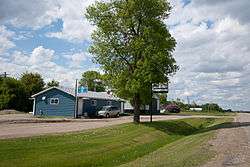 Store in Pillsbury | |
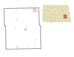 Location of Pillsbury, North Dakota | |
 Pillsbury, North Dakota Location of Pillsbury, North Dakota | |
| Coordinates: 47°12′22″N 97°47′40″W | |
| Country | United States |
| State | North Dakota |
| County | Barnes |
| Government | |
| • Mayor | Darrel Brudevold (as of 2008)[1] |
| Area | |
| • Total | 0.26 sq mi (0.67 km2) |
| • Land | 0.26 sq mi (0.67 km2) |
| • Water | 0 sq mi (0 km2) |
| Elevation | 1,280 ft (390 m) |
| Population | |
| • Total | 12 |
| • Estimate (2018)[4] | 11 |
| • Density | 46/sq mi (18/km2) |
| Time zone | UTC-6 (Central (CST)) |
| • Summer (DST) | UTC-5 (CDT) |
| ZIP code | 58065 |
| Area code(s) | 701 |
| FIPS code | 38-62540 |
| GNIS feature ID | 1030713[5] |
Geography
Pillsbury is located at 47°12′22″N 97°47′40″W (47.206162, -97.794467).[7]
According to the United States Census Bureau, the city has a total area of 0.26 square miles (0.67 km2), all of it land.[2]
Demographics
| Historical population | |||
|---|---|---|---|
| Census | Pop. | %± | |
| 1920 | 142 | — | |
| 1930 | 260 | 83.1% | |
| 1940 | 161 | −38.1% | |
| 1950 | 119 | −26.1% | |
| 1960 | 76 | −36.1% | |
| 1970 | 50 | −34.2% | |
| 1980 | 46 | −8.0% | |
| 1990 | 31 | −32.6% | |
| 2000 | 24 | −22.6% | |
| 2010 | 12 | −50.0% | |
| Est. 2018 | 11 | [4] | −8.3% |
| U.S. Decennial Census[8] 2018 Estimate[9] | |||
2010 census
As of the census[3] of 2010, there were 12 people, 8 households, and 4 families living in the city. The population density was 46.2 inhabitants per square mile (17.8/km2). There were 12 housing units at an average density of 46.2 per square mile (17.8/km2). The racial makeup of the city was 100.0% White.
There were 8 households of which 50.0% were married couples living together and 50.0% were non-families. 50.0% of all households were made up of individuals and 12.5% had someone living alone who was 65 years of age or older. The average household size was 1.50 and the average family size was 2.00.
The median age in the city was 64.5 years. 0.0% of residents were under the age of 18; 0.0% were between the ages of 18 and 24; 8.3% were from 25 to 44; 41.7% were from 45 to 64; and 50% were 65 years of age or older. The gender makeup of the city was 58.3% male and 41.7% female.
2000 census
As of the census of 2000, there were 24 people, 11 households, and six families living in the city. The population density was 96.1 people per square mile (37.1/km²). There were 11 housing units at an average density of 44.0 per square mile (17.0/km²). The racial makeup of the city was 87.50% White and 12.50% Native American.
There were 11 households out of which 27.3% had children under the age of 18 living with them, 63.6% were married couples living together, and 36.4% were non-families. 36.4% of all households were made up of individuals and 18.2% had someone living alone who was 65 years of age or older. The average household size was 2.18 and the average family size was 2.86.
In the city, the population was spread out with 20.8% under the age of 18, 8.3% from 18 to 24, 25.0% from 25 to 44, 37.5% from 45 to 64, and 8.3% who were 65 years of age or older. The median age was 43 years. For every 100 females, there were 166.7 males. For every 100 females age 18 and over, there were 171.4 males.
The median income for a household in the city was $24,583, and the median income for a family was $30,000. Males had a median income of $43,750 versus $12,500 for females. The per capita income for the city was $10,137. There were no families and 11.1% of the population living below the poverty line, including no under eighteens and 100% of those over 64.
2008 city election
Pillsbury made international headlines in 2008 when no residents of the city showed up to vote in the city's primary election on June 10. While names were on the ballot for each available position, nobody was being challenged.[10] According to the Barnes County Auditor, those in office are allowed to appoint people, including themselves, to the open positions until the next election.[11]
References
- MacPherson, James, Voter turnout zero in Pillsbury, Associated Press, 2008-06-16, retrieved 2008-06-16
- "US Gazetteer files 2010". United States Census Bureau. Archived from the original on 2012-07-02. Retrieved 2012-06-14.
- "U.S. Census website". United States Census Bureau. Retrieved 2012-06-14.
- "Population and Housing Unit Estimates". Retrieved June 11, 2019.
- "US Board on Geographic Names". United States Geological Survey. 2007-10-25. Retrieved 2008-01-31.
- "2010 Census Redistricting Data (Public Law 94-171) Summary File". American FactFinder. United States Census Bureau. Retrieved 2 May 2011.
- "US Gazetteer files: 2010, 2000, and 1990". United States Census Bureau. 2011-02-12. Retrieved 2011-04-23.
- United States Census Bureau. "Census of Population and Housing". Retrieved October 31, 2013.
- "Population Estimates". United States Census Bureau. Retrieved June 11, 2019.
- Stell Dir vor, es ist Wahl und keiner geht hin June 18, 2008 tageschau.de (in German) Retrieved on June 19, 2008
- Retrieved on July 10, 2008
Municipalities and communities of Barnes County, North Dakota, United States | ||
|---|---|---|
| Cities | 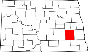 Map of North Dakota highlighting Barnes County | |
| Townships |
| |
| Unincorporated communities | ||
| Footnotes | ‡This populated place also has portions in an adjacent county or counties | |
| Authority control |
|
|---|