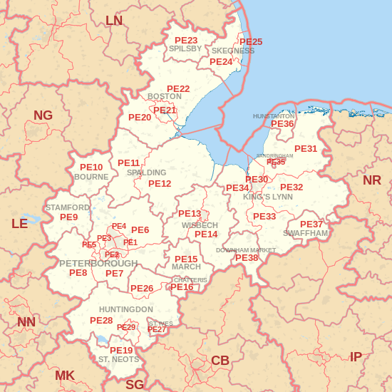
| Postcode district |
Post town |
Coverage |
Local authority area |
| PE1 |
PETERBOROUGH |
Peterborough, Dogsthorpe, Eastfield, Eastgate, Fengate, Newark, Parnwell |
Peterborough |
| PE2 |
PETERBOROUGH |
Alwalton, Fletton, The Ortons, Stanground, Woodston |
Peterborough |
| PE3 |
PETERBOROUGH |
Peterborough, Bretton, Longthorpe, Netherton, Ravensthorpe, Westwood |
Peterborough |
| PE4 |
PETERBOROUGH |
Gunthorpe, Paston, Walton, Werrington |
Peterborough |
| PE5 |
PETERBOROUGH |
Ailsworth, Castor, Sutton |
Peterborough |
| PE6 |
PETERBOROUGH |
Baston, Crowland, The Deepings, Eye, Glinton, Langtoft, Northborough, Upton |
South Kesteven, Peterborough |
| PE7 |
PETERBOROUGH |
Coates, Farcet, Folksworth, Hampton, Stilton, Yaxley, Whittlesey |
Peterborough, Huntingdonshire, Fenland |
| PE8 |
PETERBOROUGH |
Achurch, Apethorpe, Armston, Ashton, Barnwell, Blatherwycke, Cotterstock, Elton, Fotheringhay, Hemington, Kings Cliffe, Lower Benefield, Luddington, Nassington, Oundle, Polebrook, Sibson, Southwick, Stibbington, Tansor, Thornhaugh, Thurning, Upper Benefield, Wadenhoe, Wansford, Warmington, Water Newton, Wigsthorpe, Wittering, Woodnewton, Yarwell |
East Northamptonshire |
| PE9 |
STAMFORD |
Stamford, Ashton, Aunby, Bainton, Barholm, Barnack, Braceborough, Careby, Carlby, Collyweston, Duddington, Essendine, Easton-on-the-Hill, Great Casterton, Greatford, Ketton, Little Casterton, Newstead, Pickworth, Pilsgate, Ryhall, Southorpe, Tallington, Tickencote, Tinwell, Tixover, Uffington, Ufford, Wilsthorpe, Wothorpe |
South Kesteven, Rutland, East Northamptonshire |
| PE10 |
BOURNE |
Bourne, Bulby, Cawthorpe, Dowsby, Dunsby, Dyke, Edenham, Grimsthorpe, Haconby, Hanthorpe, Keisby, Kirkby Underwood, Lound, Manthorpe, Morton, Rippingale, Scottlethorpe, Stainfield, Thurlby, Toft, Twenty, Witham on the Hill |
South Kesteven |
| PE11 |
SPALDING |
Spalding (most of), Deeping St. Nicholas, Donington, Gosberton, Hop Pole, Pinchbeck, Pode Hole, Quadring, Quadring Fen, Surfleet, Tongue End |
South Holland |
| PE12 |
SPALDING |
Spalding (eastern outskirts), Cowbit, Gedney, Holbeach, Fleet, Holbeach, Holbeach Drove, Little Sutton, Long Sutton, Moulton, Sutton Bridge, Weston, Weston Hills, Whaplode |
South Holland |
| PE13 |
WISBECH |
Wisbech (most of), Guyhirn, Murrow, Parson Drove, Tydd St. Giles, Wisbech St. Mary |
Fenland |
| PE14 |
WISBECH |
Wisbech (outskirts), Elm, Emneth, Emneth Hungate, Marshland St. James, Outwell, Terrington St. John, Tipps End, Upwell, Walpole Highway, Walpole St Peter, Walpole St Andrew, Walsoken, Welney, West Walton |
Fenland, King's Lynn and West Norfolk |
| PE15 |
MARCH |
March, Benwick, Doddington, Manea, Wimblington |
Fenland |
| PE16 |
CHATTERIS |
Chatteris, Swingbrow |
Fenland |
| PE19 |
ST. NEOTS |
St Neots, Abbotsley, Buckden, Croxton, Diddington, Duloe, Eaton Ford, Eaton Socon, Eltisley, Eynesbury, Graveley, Great Paxton, Great Staughton, Hail Weston, Honeydon, Little Barford, Little Paxton, Offord Cluny, Southoe, Staploe, Toseland, Yelling |
Huntingdonshire, Bedford |
| PE20 |
BOSTON |
Algarkirk, Amber Hill, Bicker, Brothertoft, Fosdyke, Frampton, Kirton, Sutterton, Swineshead, Wigtoft |
Boston |
| PE21 |
BOSTON |
Boston, Fishtoft, Wyberton |
Boston |
| PE22 |
BOSTON |
Benington, Butterwick, Carrington, Eastville, Freiston, Friskney, Frithville, Langrick, Leverton, Mareham-le-Fen, Moorby, New Bolingbroke, Old Leake, Revesby, Stickney, Wrangle |
Boston |
| PE23 |
SPILSBY |
Spilsby, Asgarby, Aswardby, Bag Enderby, Dalby, East Kirkby, Firsby, Halton Holegate, Harrington, Keal Cotes, Langton, Mavis Enderby, Monksthorpe, Partney, Sausthorpe, Somersby |
East Lindsey |
| PE24 |
SKEGNESS |
Addlethorpe, Anderby, Anderby Creek, Ashington End, Bratoft, Burgh Le Marsh, Chapel St Leonards, Croft, Hogsthorpe, Orby, Wainfleet |
East Lindsey |
| PE25 |
SKEGNESS |
Skegness, Croft, Ingoldmells, Roman Bank |
East Lindsey |
| PE26 |
HUNTINGDON |
Huntingdon, Ramsey, Bury, Ramsey Mereside, Upwood |
Huntingdonshire |
| PE27 |
ST. IVES |
St Ives, Holywell, Needingworth |
Huntingdonshire |
| PE28 |
HUNTINGDON |
Abbots Ripton, Alconbury, Alconbury Weston, Barham, Bluntisham, Brampton, Broughton, Buckworth, Bythorn, Catworth, Colne, Coppingford, Covington, Earith, Easton, Ellington, Fenstanton, Glatton, Grafham, Great Gidding, Great Stukeley, Hamerton, Hartford, Hemingford Abbots, Hemingford Grey, Hilton, Houghton, Keyston, Kimbolton, Kings Ripton, Leighton Bromswold, Little Gidding, Little Stukeley, Lower Dean, Molesworth, Old Hurst, Old Weston, Perry, Pidley, Sawtry, Somersham, Spaldwick, Stow Longa, Tilbrook, Upper Dean, Warboys, Wennington, Winwick, Wistow, Woodhurst, Woodwalton, Woolley, Wyton |
Huntingdonshire, Bedford |
| PE29 |
HUNTINGDON |
Huntingdon, Godmanchester, Hartford, Hinchingbrooke |
Huntingdonshire |
| PE30 |
KING'S LYNN |
King's Lynn, North Wootton, South Wootton |
King's Lynn and West Norfolk |
| PE31 |
KING'S LYNN |
Brancaster, Burnham Thorpe, Heacham, Snettisham, Wolferton, Burnham Market |
King's Lynn and West Norfolk |
| PE32 |
KING'S LYNN |
East Lexham, East Winch, Leziate, Middleton, Mileham, Narborough |
King's Lynn and West Norfolk, Breckland |
| PE33 |
KING'S LYNN |
Barton Bendish, Fincham, Gooderstone |
King's Lynn and West Norfolk, Breckland |
| PE34 |
KING'S LYNN |
Clenchwarton, Islington, Stow Bardolph, Terrington St Clement, Tilney All Saints, Tilney St. Lawrence, Walpole Cross Keys, West Lynn, Wimbotsham |
King's Lynn and West Norfolk |
| PE35 |
SANDRINGHAM |
Sandringham |
King's Lynn and West Norfolk |
| PE36 |
HUNSTANTON |
Hunstanton, Holme, Ringstead, Sedgeford, Thornham |
King's Lynn and West Norfolk |
| PE37 |
SWAFFHAM |
Swaffham, Beachamwell, Cockley Cley, Necton, North Pickenham, South Pickenham |
Breckland |
| PE38 |
DOWNHAM MARKET |
Downham Market, Salters Lode |
King's Lynn and West Norfolk |
| PE99 |
PETERBOROUGH |
|
non-geographic |