WA postcode area
Postcode district boundaries:
| Warrington postcode area | |
|---|---|
 WA | |
| Postcode area | WA |
| Postcode area name | Warrington |
| Post towns | 9 |
| Postcode districts | 18 |
| Postcode sectors | 97 |
| Postcodes (live) | 18,078 |
| Postcodes (total) | 24,558 |
| Statistics as at February 2012[1] | |
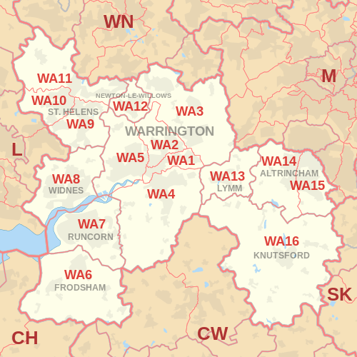
The WA postcode area, also known as the Warrington postcode area,[2] is a group of sixteen postcode districts in England, which are subdivisions of nine post towns. These postcode districts cover north Cheshire (including Warrington, Frodsham, Knutsford, Lymm, Runcorn and Widnes), eastern Merseyside (including St Helens and Newton-le-Willows) and small parts of Greater Manchester (including Altrincham and Golborne).
Coverage
The approximate coverage of the postcode districts:
| Postcode district | Post town | Coverage | Local authority area |
|---|---|---|---|
| WA1 | WARRINGTON | Warrington, Town Centre, Woolston, Paddington, Bruche | Warrington |
| WA2 | WARRINGTON | Warrington, Orford, Longford, Dallam, Padgate, Fearnhead | Warrington |
| WA3 | WARRINGTON | Lowton, Golborne, Birchwood, Rixton with Glazebrook, Culcheth | Wigan, Warrington |
| WA4 | WARRINGTON | Warrington, Latchford, Stockton Heath, Appleton, Grappenhall, Daresbury, Moore, Walton, Preston on the Hill | Warrington, Halton, Cheshire West and Chester |
| WA5 | WARRINGTON | Warrington, Burtonwood, Westbrook, Penketh, Great Sankey, White Cross | Warrington |
| WA6 | FRODSHAM | Frodsham, Helsby | Cheshire West and Chester |
| WA7 | RUNCORN | Runcorn | Halton |
| WA8 | WIDNES | Widnes, Cronton | Halton, Knowsley |
| WA9 | ST. HELENS | Clock Face, Sutton, Thatto Heath | St Helens |
| WA10 | ST. HELENS | Eccleston, St. Helens, West Park | St Helens |
| WA11 | ST. HELENS | Crank, Haydock, Moss Bank, Rainford | St Helens |
| WA12 | NEWTON-LE-WILLOWS | Newton-le-Willows, Earlestown | St Helens |
| WA13 | LYMM | Lymm, Statham, Warburton | Warrington, Trafford |
| WA14 | ALTRINCHAM | Altrincham, Bowdon, Broadheath, Dunham Town, Timperley, Dunham Massey, Little Bollington | Trafford, Cheshire East |
| WA15 | ALTRINCHAM | Altrincham, Ashley, Hale, Hale Barns, Timperley, Ringway | Trafford, Manchester, Cheshire East |
| WA16 | KNUTSFORD | High Legh, Knutsford, Mobberley, Ollerton | Cheshire East |
| WA55 | WARRINGTON | Non-geographic | |
| WA88 | WIDNES | Non-geographic |
The Frodsham post town was introduced in June 1999; the post town for WA6 had previously been Warrington.[3]
Map
See also
References
- ↑ "ONS Postcode Directory Version Notes" (ZIP). National Statistics Postcode Products. Office for National Statistics. February 2012. Table 2. Retrieved 21 April 2012. Coordinates from mean of unit postcode points, "Code-Point Open". OS OpenData. Ordnance Survey. February 2012. Retrieved 21 April 2012.
- ↑ Royal Mail, Address Management Guide, (2004)
- ↑ Royal Mail (ftp site) - Royal Mail major recode historical information - 1990 to 1999
External links
This article is issued from
Wikipedia.
The text is licensed under Creative Commons - Attribution - Sharealike.
Additional terms may apply for the media files.