BA postcode area
Postcode district boundaries:
| Bath postcode area | |
|---|---|
 BA | |
| Postcode area | BA |
| Postcode area name | Bath |
| Post towns | 16 |
| Postcode districts | 19 |
| Postcode sectors | 81 |
| Postcodes (live) | 14,852 |
| Postcodes (total) | 18,964 |
| Statistics as at February 2012[1] | |
The BA postcode area, also known as the Bath postcode area,[2] is a group of nineteen postcode districts in England, which are subdivisions of sixteen post towns. These postcode districts cover south and east Somerset (including Bath, Yeovil, Bruton, Castle Cary, Frome, Glastonbury, Radstock, Shepton Mallet, Street, Templecombe, Wells and Wincanton) and west Wiltshire (including Bradford on Avon, Trowbridge, Warminster and Westbury).
Coverage
The approximate coverage of the postcode districts:
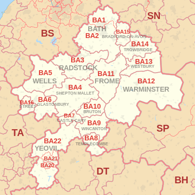
| Postcode district | Post town | Coverage | Local authority area |
|---|---|---|---|
| BA1 | BATH | Bath north of the Avon, Batheaston | Bath and North East Somerset |
| BA2 | BATH | Bath south of the Avon, Farmborough, Timsbury, Peasedown St John, Wellow, Hinton Charterhouse, Norton St Philip, Freshford, Limpley Stoke | Bath and North East Somerset |
| BA3 | RADSTOCK | Radstock, Midsomer Norton, Holcombe, Coleford | Bath and North East Somerset |
| BA4 | SHEPTON MALLET | Shepton Mallet | Mendip |
| BA5 | WELLS | Wells | Mendip |
| BA6 | GLASTONBURY | Glastonbury | Mendip |
| BA7 | CASTLE CARY | Castle Cary | South Somerset |
| BA8 | TEMPLECOMBE | Templecombe | South Somerset |
| BA9 | BRUTON | non-geographic[3][4] | |
| BA9 | WINCANTON | Wincanton | South Somerset |
| BA10 | BRUTON | Bruton | South Somerset |
| BA11 | FROME | Frome | Mendip |
| BA12 | WARMINSTER | Warminster | Wiltshire |
| BA13 | WESTBURY | Westbury | Wiltshire |
| BA14 | TROWBRIDGE | Trowbridge | Wiltshire |
| BA15 | BRADFORD-ON-AVON | Bradford-on-Avon, Winsley | Wiltshire |
| BA16 | STREET | Street | Mendip |
| BA20 | YEOVIL | Yeovil | South Somerset |
| BA21 | YEOVIL | Yeovil, Mudford | South Somerset |
| BA22 | YEOVIL | Yeovil, East & West Coker, Ilchester | South Somerset |
Map
See also
References
- ↑ "ONS Postcode Directory Version Notes" (ZIP). National Statistics Postcode Products. Office for National Statistics. February 2012. Table 2. Retrieved 21 April 2012. Coordinates from mean of unit postcode points, "Code-Point Open". OS OpenData. Ordnance Survey. February 2012. Retrieved 21 April 2012.
- ↑ Royal Mail, Address Management Guide, (2004)
- ↑ "Non Geographic Codes" (PDF). Royal Mail Address Management Unit. July 2012. Archived from the original (PDF) on 16 September 2012. Retrieved 25 October 2012.
- ↑ "New sectors and localities to 19 October 2012" (PDF). Royal Mail Address Management Unit. 19 October 2012. Archived from the original (PDF) on 13 May 2013. Retrieved 25 October 2012.
External links
This article is issued from
Wikipedia.
The text is licensed under Creative Commons - Attribution - Sharealike.
Additional terms may apply for the media files.