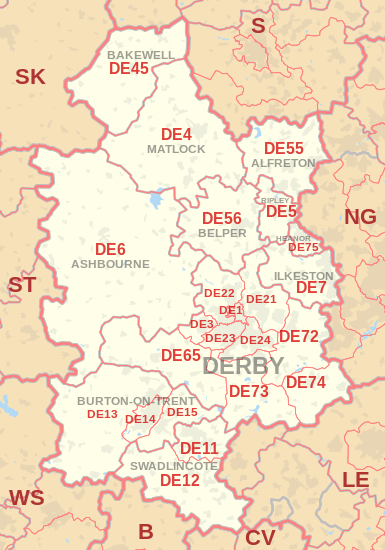
| Postcode district |
Post town |
Coverage |
Local authority area |
| DE1 |
DERBY |
Derby city centre |
Derby |
| DE3 |
DERBY |
Derby (Mickleover) |
Derby, South Derbyshire |
| DE4 |
MATLOCK |
Sector 2:Darley Dale, Beeley, Rowsley, Winster, Darley Bridge, Elton, Bonsall
Sector 3:Matlock, Matlock Bath, Cromford
Sector 4: Middleton-by-Wirksworth, Wirksworth, Bolehill
Sector 5: Crich, Holloway, Lea, Tansley |
Derbyshire Dales, Amber Valley |
| DE5 |
RIPLEY |
Ripley, Codnor, Denby, Waingroves, Butterley, Pentrich |
Amber Valley |
| DE6 |
ASHBOURNE |
Ashbourne, Hulland Ward, Weston Underwood |
Derbyshire Dales, Amber Valley, South Derbyshire, Derby, East Staffordshire |
| DE7 |
ILKESTON |
Horsley Woodhouse, Ilkeston, Morley, West Hallam |
Erewash, Amber Valley, Broxtowe |
| DE11 |
SWADLINCOTE |
Swadlincote, Church Gresley, Woodville, Newhall, Hartshorne, Castle Gresley, Blackfordby, Albert Village |
South Derbyshire, North West Leicestershire |
| DE12 |
SWADLINCOTE |
Appleby Magna, Donisthorpe, Linton, Measham, Overseal, Rosliston, Walton-on-Trent |
North West Leicestershire, South Derbyshire |
| DE13 |
BURTON-ON-TRENT |
Alrewas, Barton-under-Needwood, Rolleston on Dove, Tutbury |
East Staffordshire, Lichfield |
| DE14 |
BURTON-ON-TRENT |
Branston, Burton upon Trent, Newton Solney, Winshill |
East Staffordshire, South Derbyshire |
| DE15 |
BURTON-ON-TRENT |
Bretby, Stapenhill |
East Staffordshire, South Derbyshire |
| DE21 |
DERBY |
Derby (Chaddesden, Oakwood, Spondon); Breadsall, Horsley, Little Eaton |
Derby, Erewash, Amber Valley |
| DE22 |
DERBY |
Derby (Allestree, Darley Abbey, Mackworth (estate)); Kedleston, Mackworth (village), Quarndon |
Derby, Amber Valley |
| DE23 |
DERBY |
Derby (Heatherton Village, Littleover, Normanton, Pear Tree, Sunny Hill) |
Derby, South Derbyshire |
| DE24 |
DERBY |
Derby (Allenton, Alvaston, Boulton, Osmaston, Shelton Lock, Sinfin, Wilmorton); Stenson Fields |
Derby, South Derbyshire |
| DE45 |
BAKEWELL |
Ashford-in-the-Water, Bakewell, Baslow, Chatsworth, Edensor, Hassop, Monyash, Youlgreave |
Derbyshire Dales |
| DE55 |
ALFRETON |
Sector 1: Swanwick
Sectors 2 and 3: Alfreton, South Normanton
Sector 4: Riddings, Greenhill Lane, Leabrooks, Somercotes
Sector 5: Tibshelf, Newton, Blackwell, Hilcote
Sector 6: Wessington, Higham, Stonebroom, Morton, Shirland
Sector 7: Alfreton, South Wingfield |
Amber Valley, Bolsover |
| DE56 |
BELPER |
Ambergate, Belper, Duffield, Heage, Holbrook, Kilburn, Milford |
Amber Valley |
| DE65 |
DERBY |
Burnaston, Egginton, Etwall, Findern, Hatton, Hilton, Milton, Repton, Willington |
South Derbyshire |
| DE72 |
DERBY |
Ambaston, Aston-on-Trent, Borrowash, Breaston, Church Wilne, Draycott, Elvaston, Ockbrook, Risley, Shardlow, Weston-on-Trent |
Erewash, South Derbyshire, North West Leicestershire |
| DE73 |
DERBY |
Derby (Chellaston); Barrow upon Trent, Ingleby, Melbourne, Stanton by Bridge, Swarkestone, Ticknall |
Derby, South Derbyshire |
| DE74 |
DERBY |
Castle Donington, Kegworth, Diseworth, Hemington, Lockington, East Midlands Airport |
North West Leicestershire, Rushcliffe |
| DE75 |
HEANOR |
Heanor, Loscoe, Shipley |
Amber Valley |
| DE99 |
DERBY |
|
non-geographic |