Holbeach Drove
| Holbeach Drove | |
|---|---|
 Holbeach Drove Holbeach Drove shown within Lincolnshire | |
| OS grid reference | TF326123 |
| • London | 80 mi (130 km) S |
| District | |
| Shire county | |
| Region | |
| Country | England |
| Sovereign state | United Kingdom |
| Post town | SPALDING |
| Postcode district | PE11 |
| Dialling code | 01406 |
| Police | Lincolnshire |
| Fire | Lincolnshire |
| Ambulance | East Midlands |
| EU Parliament | East Midlands |
| UK Parliament | |
Holbeach Drove is a village in the South Holland district of Lincolnshire, England. It is situated approximately 5 miles (8 km) east from Crowland, and at the junction of the B1166 and the B1168 roads.
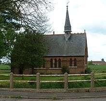
St Polycarp's Church, Holbeach Drove
The village church is dedicated to St Polycarp. There is one local public house, the Golden Ball, and a shop-cum-petrol station.
External links

England Portal | |
| Unitary authorities | |
| Boroughs or districts | |
| Major settlements |
|
| Topics | |
This article is issued from
Wikipedia.
The text is licensed under Creative Commons - Attribution - Sharealike.
Additional terms may apply for the media files.