SP postcode area
Postcode district boundaries:
| Salisbury postcode area | |
|---|---|
 SP | |
| Postcode area | SP |
| Postcode area name | Salisbury |
| Post towns | 6 |
| Postcode districts | 11 |
| Postcode sectors | 47 |
| Postcodes (live) | 8,355 |
| Postcodes (total) | 10,691 |
| Statistics as at February 2012[1] | |
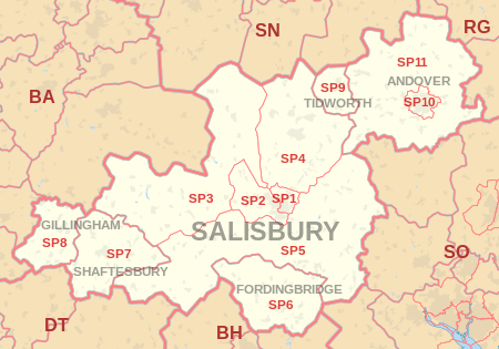
The SP postcode area, also known as the Salisbury postcode area,[2] is a group of eleven postcode districts in England, which are subdivisions of six post towns. These postcode districts cover south Wiltshire and parts of north Dorset and west Hampshire, including Salisbury, Andover, Fordingbridge, Gillingham, Shaftesbury and Tidworth.
The letters in the postcode refer to the Salisbury Plain, a plateau within the postcode area.
Coverage
The approximate coverage of the postcode districts:
Map
See also
References
- ↑ "ONS Postcode Directory Version Notes" (ZIP). National Statistics Postcode Products. Office for National Statistics. February 2012. Table 2. Retrieved 21 April 2012. Coordinates from mean of unit postcode points, "Code-Point Open". OS OpenData. Ordnance Survey. February 2012. Retrieved 21 April 2012.
- ↑ Royal Mail, Address Management Guide, (2004)
External links
This article is issued from
Wikipedia.
The text is licensed under Creative Commons - Attribution - Sharealike.
Additional terms may apply for the media files.