Sedgeford
| Sedgeford | |
|---|---|
 Magazine, the old gunpowder store at Sedgeford | |
 Sedgeford Sedgeford shown within Norfolk | |
| Area | 17.06 km2 (6.59 sq mi) |
| Population | 613 (2011) |
| • Density | 36/km2 (93/sq mi) |
| OS grid reference | TF712366 |
| • London | 170 km (110 mi) |
| Civil parish |
|
| District | |
| Shire county | |
| Region | |
| Country | England |
| Sovereign state | United Kingdom |
| Post town | HUNSTANTON |
| Postcode district | PE36 |
| Police | Norfolk |
| Fire | Norfolk |
| Ambulance | East of England |
| EU Parliament | East of England |
Sedgeford is a civil parish in the English county of Norfolk, about 6 km south of the North Sea and 5 km (3.1 mi) east of the Wash. It is approximately 90 km (56 mi) north east of Cambridge. It covers an area of 17.06 km2 (6.59 sq mi) and had a population of 540 in 224 households as of the 2001 census,[1] the population including Fring and increasing to 613 at the 2011 Census.[2] For the purposes of local government, it falls within the district of King's Lynn and West Norfolk.

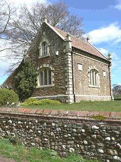
The parish church, Sedgeford St. Mary, is one of 124 round-tower churches in Norfolk.
The village lies in a fertile valley in the belt of chalk covering this area, with the small Docking river running through it. This river and the many springs feeding it have always ensured a good water supply for successive groups of people who have settled near it in the past.
The village is recorded in the Domesday Book in 1086. Part of the church, built of flint and stone, is Anglo-Saxon in origin, and it is known from archæological evidence that people have lived here from much earlier times. There are remains of Roman villas, pottery and a gold torc from the Iron Age and many earlier artefacts, like the Neolithic flint tools which are found in fields and gardens. Also it is crossed by two ancient roads - the prehistoric Icknield Way and the Roman-period the Peddars Way.
This is a predominantly agricultural area, with barley, wheat and sugar beet as the main crops, although tourism has become increasingly important in recent years.
Sedgeford has a village football team, Sedgeford FC.
Peddars Way
Peddars Way, the ancient Roman road, runs through the top end of the village and leads directly onto the Norfolk Coastal path. After Fring, the national trail passes through the hamlet of Littleport, a small row of higgledy-piggledy cottages which now form part of the main village. The route takes walkers past a local landmark Magazine Cottage, built in the 17th century by the Le Strange family during the civil war as a gunpowder magazine. Legend has it that a secret tunnel ran from the old armoury to the church in the heart of the village. Today this small part of Peddars Way has derived its name from this historical building with Magazine Wood and Magazine Farm just a few steps away. All these properties were formerly owned by William Newcombe-Baker, a local land owner whose estate formed much of the land surrounding the village. He was also a founder member of NORMAC, the Norfolk machinery body that did much in the 20th century to bring modern mechanisation to arable farming in East Anglia. Magazine Wood was rebuilt in 2000 and from this high vantage point on Peddars Way you can witness the sun setting over the sea - one of the very few places this is possible on the east coast of Britain.

Peddars Way passes Magazine Farm and then crosses the old railway-line. Sedgeford formerly had its own Sedgeford railway station on the line between Wells and King's Lynn, but this was finally closed in 1963.
Archaeological project
The Sedgeford Historical and Archaeological Research Project (SHARP) was established in 1996 to reconstruct the story of human settlement in the parish. This is an ongoing project; further details can be found on www.sharp.org.uk.
Bibliography
Notes
- ↑ Census population and household counts for unparished urban areas and all parishes Archived 2017-02-11 at the Wayback Machine.. Office for National Statistics & Norfolk County Council (2001). Retrieved 20 June 2009.
- ↑ "Civil Parish population 2011". Retrieved 29 August 2015.
External links
| Wikimedia Commons has media related to Sedgeford. |