BL postcode area
Postcode district boundaries:
| Bolton postcode area | |
|---|---|
 BL | |
| Postcode area | BL |
| Postcode area name | Bolton |
| Post towns | 2 |
| Postcode districts | 12 |
| Postcode sectors | 53 |
| Postcodes (live) | 10,402 |
| Postcodes (total) | 13,522 |
| Statistics as at February 2012[1] | |
The BL postcode area, also known as the Bolton postcode area,[2] is a group of postcode districts around the towns of Bolton and Bury, along with outlying areas of Chorley, Rossendale and Blackburn with Darwen, England.
Coverage
The approximate coverage of the postcode districts:
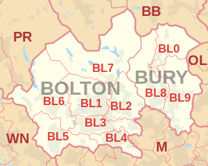
| Postcode district | Post town | Coverage | Local authority area |
|---|---|---|---|
| BL0 | BURY | Bury, Ramsbottom, Edenfield, Shuttleworth | Bury, Rossendale |
| BL1 | BOLTON | Bolton, Smithills, Halliwell, Heaton | Bolton |
| BL2 | BOLTON | Bolton, Ainsworth, Bradley Fold, Bradshaw, Breightmet, Harwood, Tonge Fold, Tonge Moor | Bolton, Bury |
| BL3 | BOLTON | Bolton, Little Lever, Great Lever, Darcy Lever, Deane | Bolton |
| BL4 | BOLTON | Bolton, Farnworth, Kearsley | Bolton |
| BL5 | BOLTON | Bolton, Over Hulton, Westhoughton | Bolton |
| BL6 | BOLTON | Bolton, Blackrod, Horwich, Lostock, Rivington | Bolton, Chorley |
| BL7 | BOLTON | Bolton, Belmont, Bromley Cross, Chapeltown, Edgworth, Egerton, Turton | Blackburn with Darwen, Bolton |
| BL8 | BURY | Bury, Brandlesholme, Greenmount, Affetside, Hawkshaw, Holcombe, Ramsbottom, Tottington, Walshaw | Bury |
| BL9 | BURY | Bury, Heap, Heap Bridge, Nangreaves, Summerseat, Unsworth, Walmersley, Bircle, Jericho | Bury |
Map
See also
References
- ↑ "ONS Postcode Directory Version Notes" (ZIP). National Statistics Postcode Products. Office for National Statistics. February 2012. Table 2. Retrieved 21 April 2012. Coordinates from mean of unit postcode points, "Code-Point Open". OS OpenData. Ordnance Survey. February 2012. Retrieved 21 April 2012.
- ↑ Royal Mail, Address Management Guide, (2004)
External links
This article is issued from
Wikipedia.
The text is licensed under Creative Commons - Attribution - Sharealike.
Additional terms may apply for the media files.