UB postcode area
Postcode district boundaries:
| Southall postcode area | |
|---|---|
 UB | |
| Postcode area | UB |
| Postcode area name | Southall |
| Post towns | 6 |
| Postcode districts | 12 |
| Postcode sectors | 41 |
| Postcodes (live) | 7,145 |
| Postcodes (total) | 11,011 |
| Statistics as at February 2012[1] | |
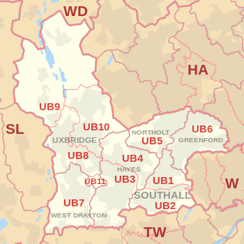
The UB postcode area, also known as the Southall postcode area,[2] is a group of eleven postcode districts in England, which are subdivisions of six post towns. These postcode districts cover parts of west and north-west London, as well as a very small part of Buckinghamshire. UB is an abbreviation of Uxbridge.
The main sorting office is in Greenford.[3] In names of London Boroughs, in quotes for clarity, it takes in most of 'Hillingdon' and roughly a western third of 'Ealing', the southern part of UB2 covers a very small part of 'Hounslow', and a very small part of UB5: 'Harrow'.
The west of UB9 covers nearly all of Denham civil parish (and all of the old village) in the South Bucks district of Buckinghamshire.
The area closely resembles an obsolete county division, Elthorne Hundred.
Coverage
The approximate coverage of the postcode districts:
| Postcode district | Post town | Coverage | Local authority area |
|---|---|---|---|
| UB1 | SOUTHALL | Southall (north) | Ealing |
| UB2 | SOUTHALL | Southall (south), Norwood Green | Ealing, Hounslow |
| UB3 | HAYES & HARLINGTON | non-geographic[4][5] | |
| UB3 | HAYES | Hayes (south), Harlington | Hillingdon |
| UB4 | HAYES | Hayes (north), Yeading | Hillingdon |
| UB5 | GREENFORD | non-geographic[4][6] | |
| UB5 | NORTHOLT | Northolt | Ealing, Harrow, Hillingdon |
| UB6 | GREENFORD | Greenford, Perivale | Ealing |
| UB7 | WEST DRAYTON | West Drayton, Harmondsworth, Sipson, Yiewsley, Longford | Hillingdon |
| UB8 | WEST DRAYTON | non-geographic[4][7] | |
| UB8 | UXBRIDGE | Uxbridge, Cowley, Hillingdon (part) | Hillingdon |
| UB9 | UXBRIDGE | Denham, Harefield | Hillingdon, South Bucks |
| UB10 | UXBRIDGE | Hillingdon, Ickenham | Hillingdon |
| UB11 | UXBRIDGE | Stockley Park | Hillingdon |
| UB18 | GREENFORD | Spring International | non-geographic[4][8] |
Map
See also
- Elthorne Hundred, the obsolete county division which this area closely resembles.
- Postcode Address File
- List of postcode areas in the United Kingdom
References
- ↑ "ONS Postcode Directory Version Notes" (ZIP). National Statistics Postcode Products. Office for National Statistics. February 2012. Table 2. Retrieved 21 April 2012. Coordinates from mean of unit postcode points, "Code-Point Open". OS OpenData. Ordnance Survey. February 2012. Retrieved 21 April 2012.
- ↑ Royal Mail, Address Management Guide, (2004)
- ↑ Green Park Way Sorting Office, Greenford, UB6 0GG listed at e.g. http://www.118118.com/perivale-london/post-offices/1706309-royal-mail.html
- 1 2 3 4 "Non Geographic Codes" (PDF). Royal Mail Address Management Unit. July 2012. Archived from the original (PDF) on 16 September 2012. Retrieved 20 December 2012.
- ↑ "New sectors and localities to 14 December 2012" (PDF). Royal Mail Address Management Unit. 20 December 2012. Archived from the original (PDF) on 2 February 2015. Retrieved 20 December 2012.
- ↑ "New sectors and localities to 16 November 2012" (PDF). Royal Mail Address Management Unit. 19 November 2012. Retrieved 29 November 2012.
- ↑ "New sectors and localities to 19 October 2012" (PDF). Royal Mail Address Management Unit. 19 October 2012. Archived from the original (PDF) on 13 May 2013. Retrieved 25 October 2012.
- ↑ UB18 includes a series of postcodes where, unusually, the last two letters correspond to the ISO country code for various countries in the trading name of the address, such as "Spring France, GREENFORD, UB18 7FR". Royal Mail – Find an address