SS postcode area
Postcode district boundaries:
| Southend-on-Sea postcode area | |
|---|---|
 SS | |
| Postcode area | SS |
| Postcode area name | Southend-on-Sea |
| Post towns | 11 |
| Postcode districts | 19 |
| Postcode sectors | 81 |
| Postcodes (live) | 11,891 |
| Postcodes (total) | 16,540 |
| Statistics as at February 2012[1] | |
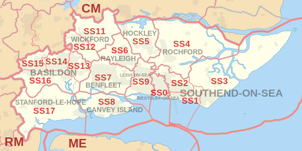
The SS postcode area, also known as the Southend-on-Sea postcode area,[2] is a group of seventeen postcode districts in England, which are subdivisions of eleven post towns. These postcode districts cover south-east Essex, including Southend-on-Sea, Basildon, Benfleet, Canvey Island, Hockley, Leigh-on-Sea, Rayleigh, Rochford, Stanford-le-Hope, Westcliff-on-Sea and Wickford.
Coverage
The approximate coverage of the postcode districts:
| Postcode district | Post town | Coverage | Local authority area |
|---|---|---|---|
| SS0 | WESTCLIFF-ON-SEA | Westcliff-on-Sea, Chalkwell | Southend-on-Sea |
| SS1 | WESTCLIFF-ON-SEA | PO Boxes[3] | non-geographic |
| SS1 | SOUTHEND-ON-SEA | Southend-on-Sea, Thorpe Bay | Southend-on-Sea |
| SS2 | SOUTHEND-ON-SEA | Southend-on-Sea, Prittlewell, Southchurch | Southend-on-Sea |
| SS3 | SOUTHEND-ON-SEA | Shoeburyness, Great Wakering, Little Wakering, Barling | Rochford, Southend-on-Sea |
| SS4 | ROCHFORD | Rochford, Ashingdon, Canewdon, Stambridge, Paglesham | Rochford |
| SS5 | HOCKLEY | Hockley, Hullbridge, Hawkwell | Rochford |
| SS6 | RAYLEIGH | Rayleigh | Rochford |
| SS7 | BENFLEET | Hadleigh, South Benfleet, Thundersley | Castle Point |
| SS8 | CANVEY ISLAND | Canvey Island | Castle Point |
| SS9 | LEIGH-ON-SEA | Eastwood, Leigh-on-Sea | Southend-on-Sea |
| SS11 | WICKFORD | Wickford | Basildon, Chelmsford, Rochford |
| SS12 | WICKFORD | Wickford, North Benfleet | Basildon |
| SS13 | BASILDON | Pitsea | Basildon |
| SS14 | BASILDON | Basildon | Basildon |
| SS15 | BASILDON | Laindon | Basildon |
| SS16 | BASILDON | Langdon Hills | Basildon |
| SS17 | STANFORD-LE-HOPE | Stanford-le-Hope, Corringham, Horndon-on-the-Hill | Thurrock |
| SS22 | SOUTHEND-ON-SEA | International Masters Publishers[3] | non-geographic |
| SS99 | SOUTHEND-ON-SEA | HM Revenue and Customs (VAT),[3] First Data[3] | non-geographic |
Map
See also
References
- ↑ "ONS Postcode Directory Version Notes" (ZIP). National Statistics Postcode Products. Office for National Statistics. February 2012. Table 2. Retrieved 21 April 2012. Coordinates from mean of unit postcode points, "Code-Point Open". OS OpenData. Ordnance Survey. February 2012. Retrieved 21 April 2012.
- ↑ Royal Mail, Address Management Guide, (2004)
- 1 2 3 4 "Non Geographic Codes" (PDF). Royal Mail Address Management Unit. July 2012. Archived from the original (PDF) on 16 September 2012. Retrieved 14 January 2013.
External links
This article is issued from
Wikipedia.
The text is licensed under Creative Commons - Attribution - Sharealike.
Additional terms may apply for the media files.