SN postcode area
Postcode district boundaries:
| Swindon postcode area | |
|---|---|
 SN | |
| Postcode area | SN |
| Postcode area name | Swindon |
| Post towns | 10 |
| Postcode districts | 23 |
| Postcode sectors | 113 |
| Postcodes (live) | 13,977 |
| Postcodes (total) | 20,155 |
| Statistics as at February 2012[1] | |
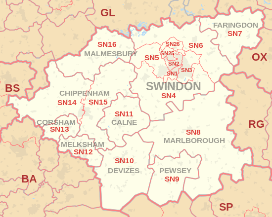
The SN postcode area, also known as the Swindon postcode area,[2] is a group of eighteen postcode districts in England, which are subdivisions of ten post towns. These postcode districts cover north Wiltshire, including Swindon, Chippenham, Calne, Corsham, Devizes, Malmesbury, Marlborough, Melksham and Pewsey, plus a small part of south-west Oxfordshire, including Faringdon, and a very small part of Gloucestershire.
Coverage
The approximate coverage of the postcode districts:
The SN25 and SN26 districts were formed out of the SN2 district in 1999.[6]
Map
See also
References
- ↑ "ONS Postcode Directory Version Notes" (ZIP). National Statistics Postcode Products. Office for National Statistics. February 2012. Table 2. Retrieved 21 April 2012. Coordinates from mean of unit postcode points, "Code-Point Open". OS OpenData. Ordnance Survey. February 2012. Retrieved 21 April 2012.
- ↑ Royal Mail, Address Management Guide, (2004)
- ↑ "SN15 postboxes". edwardbetts.com. Retrieved 11 April 2018.
- ↑ "New sectors and localities to 14 December 2012" (PDF). Royal Mail Address Management Unit. 20 December 2012. Archived from the original (PDF) on 2 February 2015. Retrieved 20 December 2012.
- 1 2 "Non Geographic Codes" (PDF). Royal Mail Address Management Unit. July 2012. Archived from the original (PDF) on September 16, 2012. Retrieved 20 December 2012.
- ↑ "Royal Mail Postcode Update 30". Beacon Dodsworth. Retrieved 22 April 2017.
External links
This article is issued from
Wikipedia.
The text is licensed under Creative Commons - Attribution - Sharealike.
Additional terms may apply for the media files.