LA postcode area
Postcode district boundaries:
| Lancaster postcode area | |
|---|---|
 LA | |
| Postcode area | LA |
| Postcode area name | Lancaster |
| Post towns | 17 |
| Postcode districts | 23 |
| Postcode sectors | 66 |
| Postcodes (live) | 11,816 |
| Postcodes (total) | 14,264 |
| Statistics as at February 2012[1] | |
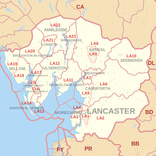
The LA postcode area, also known as the Lancaster postcode area,[2] is a group of postcode districts across north Lancashire, south Cumbria and parts of North Yorkshire. It includes Ambleside, Askam-in-Furness, Barrow-in-Furness, Broughton-in-Furness, Carnforth, Coniston, Dalton-in-Furness, Grange-over-Sands, Kendal, Kirkby-in-Furness, Lancaster, Millom, Milnthorpe, Morecambe, Sedbergh, Ulverston and Windermere in England. Despite being named after Lancaster, Lancashire, the largest settlement within the limits of the LA postcode area is Barrow-in-Furness, Cumbria.
Coverage
The approximate coverage of the postcode districts:
Map
See also
References
- ↑ "ONS Postcode Directory Version Notes" (ZIP). National Statistics Postcode Products. Office for National Statistics. February 2012. Table 2. Retrieved 21 April 2012. Coordinates from mean of unit postcode points, "Code-Point Open". OS OpenData. Ordnance Survey. February 2012. Retrieved 21 April 2012.
- ↑ Royal Mail, Address Management Guide, (2004)
- ↑ "New sectors and localities to 16 November 2012" (PDF). Royal Mail Address Management Unit. 19 November 2012. Retrieved 29 November 2012.
External links
This article is issued from
Wikipedia.
The text is licensed under Creative Commons - Attribution - Sharealike.
Additional terms may apply for the media files.