Borough of Bedford
| Bedford Borough of Bedford | ||
|---|---|---|
| Unitary Authority & Borough | ||
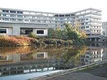 Bedford Borough Hall | ||
| ||
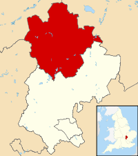 Bedford shown within Bedfordshire | ||
| Coordinates: 52°8′0″N 0°27′0″W / 52.13333°N 0.45000°W | ||
| Country | United Kingdom | |
| Constituent area | England | |
| Region | East of England | |
| Ceremonial county | Bedfordshire | |
| Admin HQ | Bedford | |
| Government | ||
| • Type | unitary authority | |
| • Governing body | Bedford Borough Council | |
| • Executive mayor |
Dave Hodgson Liberal Democrats | |
| • MPs |
Alistair Burt (C) Nadine Dorries (C) Mohammad Yasin (L) | |
| Area | ||
| • Total | 476.4 km2 (183.9 sq mi) | |
| Population mid-2017 est.[1] | ||
| • Total | 169,900 Ranked 112th | |
| • Density | 356/km2 (920/sq mi) | |
| • Ethnicity |
85.5% White 8.1% S.Asian 2.9% Black 1.3% Chinese or other 2.2% Mixed | |
| Time zone | GMT | |
| • Summer (DST) | British Summer Time | |
| ONS code | 00KB | |
| NUTS 3 | UKH22 | |
| Website | www.bedford.gov.uk | |
Bedford is a unitary authority area with borough status in the ceremonial county of Bedfordshire, England. Its council is based at Bedford, the county town of Bedfordshire. The borough contains one large urban area, the 71st largest in the United Kingdom that comprises Bedford and the adjacent town of Kempston, surrounded by a rural area with many villages. 75% of the borough's population live in the Bedford Urban Area and the five large villages which surround it, which makes up slightly less than 6% of the total land area of the Borough.
The borough is also the location of the Wixams new town development, which received its first residents in 2009.
Formation
The District of Bedford was formed on 1 April 1974 as a merger of the existing borough of Bedford, along with Kempston urban district and Bedford Rural District. In 1975 the district was granted a royal charter granting borough status as North Bedfordshire. The borough was renamed as Borough of Bedford in 1992. Over half of the former municipal borough of Bedford is unparished. However, Brickhill is a parish, and Queens Park as well as Cauldwell & Kingsbrook elect their own urban community councils, which have similar functions to parish councils. The rest of the district including Kempston is parished.
The Department for Communities and Local Government have reorganised Bedfordshire's administrative structure as part of the 2009 structural changes to local government in England, meaning that Bedford Borough Council became a unitary authority in April 2009. This means Bedford Borough has assumed responsibility in areas such as education, social services and transport which were previously provided by Bedfordshire County Council.[2][3][4]
Council and cabinet
Unlike most English districts, Bedford's council is led by a directly elected mayor of Bedford, who has been Dave Hodgson since 16 October 2009.[5]
The first elections for the new unitary Bedford Borough Council were held on 4 June 2009 when 36 councillors in addition to the mayor were elected. Since an electoral review which came into effect for the local elections in 2011, Bedford Borough has had 40 councillors in addition to the mayor.
| Year | Conservative | Labour | Liberal Democrat | Independent | Other | Control | |
|---|---|---|---|---|---|---|---|
| 2009[6] | 9 | 7 | 13 | 7 | 0 | No overall control | |
| 2011[7] | 12 | 12 | 12 | 4 | 0 | No overall control | |
Since the 2011 elections, Bedford Borough Council’s executive committee (cabinet) is headed by the mayor and includes 9 members from the Liberal Democrat, Labour, Conservative and Independent groups, only one Independent Member sits in opposition. From 2009 to 2011, Independents were included in the executive committee, while Conservative members sat in opposition on the council.[8]
Wards and civil parishes
The urban part of the borough consisting of most of the Bedford/Kempston Urban Area is divided into 13 wards, some of which are also civil parishes:[9]
| Ward name | Population (2009 estimate)[9] | Percentage from minority groups[9] |
|---|---|---|
| Brickhill | 8,540 | 14% |
| Castle | 7,190 | 32% |
| Cauldwell | 9,170 | 44% |
| De Parys | 6,840 | 18% |
| Goldington | 8,360 | 19% |
| Harpur | 8,370 | 26% |
| Kempston Central and East | 7,500 | 23% |
| Kempston North | 4,050 | 24% |
| Kempston South | 4,370 | 20% |
| Kempston West | 3,770 | 15% |
| Kingsbrook | 9,280 | 25% |
| Newnham | 7,620 | 18% |
| Putnoe | 7,650 | 14% |
| Queens Park | 8,470 | 58% |
| Total population | 101,180 | 25%[10] |

The wards and constituent civil parishes in the rural part of the borough are as follows:[9]
| Ward name | Civil Parishes[9] | Population (2009 estimate)[9] | Percentage from minority groups[9] |
|---|---|---|---|
| Biddenham & Bromham | 7,460 | 9% | |
| Clapham | Clapham | 4,670 | 9% |
| Eastcotts | Eastcotts | 3,330 | 9% |
| Elstow | 4,500 | 15% | |
| Great Barford | 6,870 | 6% | |
| Harrold | 4,240 | 4% | |
| Kempston Rural | 3,600 | 7% | |
| Oakley | 3,790 | 5% | |
| Riseley | 3,440 | 4% | |
| Sharnbrook | 4,170 | 4% | |
| Wilshamstead | Wilshamstead | 2,550 | 4% |
| Wootton | Wootton | 4,480 | 6% |
| Wyboston | 3,780 | 4% | |
| Total population | 56,880 | 7% |
See also
References
- ↑ "Population Estimates for UK, England and Wales, Scotland and Northern Ireland, Mid-2017". Office for National Statistics. 28 June 2018. Retrieved 28 June 2018.
- ↑ Unitary solution confirmed for Bedfordshire – New flagship unitary councils approved for Cheshire – Corporate – Communities and Local Government Archived 22 November 2008 at the Wayback Machine.
- ↑ County council to be abolished in shake-up – Bedford Today
- ↑ Archived 24 February 2009 at Archive.is
- ↑ "Lib Dem win in mayoral election". BBC News. 16 October 2009.
- ↑ "Lib Dems the winners in Borough Hall elections – News". Bedford Today. 5 June 2009. Retrieved 16 August 2013.
- ↑ "Bedford Borough Council elections – the results – Local". Bedford Today. 9 May 2011. Retrieved 16 August 2013.
- ↑ "Tories give new Mayor a taste of his own medicine | Bedfordshire News | Latest Bedford News Headlines | Bedfordshire Sports, Jobs, Weather & Business News". Bedfordshire News. Retrieved 16 August 2013.
- 1 2 3 4 5 6 7 "Ward Profiles". Bedford.gov.uk. 5 May 2011. Archived from the original on 6 May 2014. Retrieved 16 August 2013.
- ↑ http://www.ons.gov.uk/ons/rel/census/census-2001-key-statistics/urban-areas-in-england-and-wales/urban-areas-in-england-and-wales-ks06--ethnic-group.xls
External links
England Portal | |
| Unitary authorities | |
| Major settlements | |
| Topics |
|
Districts of the East of England | ||
|---|---|---|
| Bedfordshire | 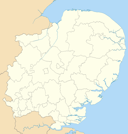 | |
| Cambridgeshire | ||
| Essex | ||
| Hertfordshire | ||
| Norfolk | ||
| Suffolk |
| |