Northamptonshire
Coordinates: 52°17′N 0°50′W / 52.283°N 0.833°W
| Northamptonshire | |||||
|---|---|---|---|---|---|
| County | |||||
| |||||
|
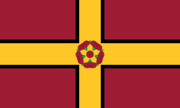
Motto: Rosa concordiae signum[1] The rose, emblem of harmony | |||||
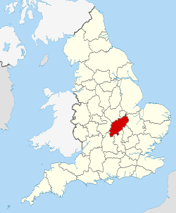 Northamptonshire in England | |||||
| Sovereign state |
| ||||
| Country |
| ||||
| Region | East Midlands | ||||
| Ceremonial county | |||||
| Lord Lieutenant | David Laing[2] | ||||
| High Sheriff | James Michael Ross Saunders Watson of Rockingham Castle [3] (2018/19) | ||||
| Area | 2,364 km2 (913 sq mi) | ||||
| • Ranked | 24th of 48 | ||||
| Population (mid-2017 est.) | 741,200 | ||||
| • Ranked | 33rd of 48 | ||||
| Density | 313/km2 (810/sq mi) | ||||
| Ethnicity |
85.7% White British 4.7% Other White 2.5% South Asian 2.5% Black British 4.6% Other | ||||
| Non-metropolitan county | |||||
| County council | Northamptonshire County Council | ||||
| Executive | Conservative | ||||
| Admin HQ | Northampton | ||||
| Area | 2,364 km2 (913 sq mi) | ||||
| • Ranked | 22nd of 27 | ||||
| Population | 741,200 | ||||
| • Ranked | 15th of 27 | ||||
| Density | 313/km2 (810/sq mi) | ||||
| ISO 3166-2 | GB-NTH | ||||
| ONS code | 34 | ||||
| NUTS | UKF23 | ||||
 Unitary County council area Districts of Northamptonshire | |||||
| Districts | |||||
| Members of Parliament | |||||
| Time zone | Greenwich Mean Time (UTC) | ||||
| • Summer (DST) | British Summer Time (UTC+1) | ||||

Northamptonshire (/nɔːrˈθæmptənʃər,
Covering an area of 2,364 square kilometres (913 sq mi), Northamptonshire is landlocked between eight other counties: Warwickshire to the west, Leicestershire and Rutland to the north, Cambridgeshire to the east, Bedfordshire to the south-east, Buckinghamshire to the south, Oxfordshire to the south-west and Lincolnshire to the north-east – England's shortest administrative county boundary at 19 metres (20 yards).[4] Northamptonshire is the southernmost county in the East Midlands region.
Apart from the county town of Northampton, other major population centres include Kettering, Corby, Wellingborough, Rushden and Daventry. Northamptonshire's county flower is the cowslip.[5]
History
Much of Northamptonshire's countryside appears to have remained somewhat intractable with regards to early human occupation, resulting in an apparently sparse population and relatively few finds from the Palaeolithic, Mesolithic and Neolithic periods.[6] In about 500 BC the Iron Age was introduced into the area by a continental people in the form of the Hallstatt culture,[7] and over the next century a series of hill-forts were constructed at Arbury Camp, Rainsborough camp, Borough Hill, Castle Dykes, Guilsborough, Irthlingborough, and most notably of all, Hunsbury Hill. There are two more possible hill-forts at Arbury Hill (Badby) and Thenford.[7]
In the 1st century BC, most of what later became Northamptonshire became part of the territory of the Catuvellauni, a Belgic tribe, the Northamptonshire area forming their most northerly possession.[7] The Catuvellauni were in turn conquered by the Romans in 43 AD.[8]
The Roman road of Watling Street passed through the county, and an important Roman settlement, Lactodorum, stood on the site of modern-day Towcester. There were other Roman settlements at Northampton, Kettering and along the Nene Valley near Raunds. A large fort was built at Longthorpe.[7]
After the Romans left, the area eventually became part of the Anglo-Saxon kingdom of Mercia, and Northampton functioned as an administrative centre. The Mercians converted to Christianity in 654 AD with the death of the pagan king Penda.[9] From about 889 the area was conquered by the Danes (as at one point almost all of England was, except for Athelney marsh in Somerset) and became part of the Danelaw - with Watling Street serving as the boundary - until being recaptured by the English under the Wessex king Edward the Elder, son of Alfred the Great, in 917. Northamptonshire was conquered again in 940, this time by the Vikings of York, who devastated the area, only for the county to be retaken by the English in 942.[10] Consequently, it is one of the few counties in England to have both Saxon and Danish town-names and settlements.
The county was first recorded in the Anglo-Saxon Chronicle (1011), as Hamtunscire: the scire (shire) of Hamtun (the homestead). The "North" was added to distinguish Northampton from the other important Hamtun further south: Southampton - though the origins of the two names are in fact different.[11]
Rockingham Castle was built for William the Conqueror[12] and was used as a Royal fortress until Elizabethan times. In 1460, during the Wars of the Roses, the Battle of Northampton took place and King Henry VI was captured.[13] The now-ruined Fotheringhay Castle was used to imprison Mary, Queen of Scots, before her execution.[14]

George Washington, the first President of the United States of America, was born into the Washington family who had migrated to America from Northamptonshire in 1656. George Washington's ancestor, Lawrence Washington, was Mayor of Northampton on several occasions and it was he who bought Sulgrave Manor from Henry VIII in 1539. It was George Washington's great-grandfather, John Washington, who emigrated in 1656 from Northants to Virginia. Before Washington's ancestors moved to Sulgrave, they lived in Warton, Lancashire.[15]
During the English Civil War, Northamptonshire strongly supported the Parliamentarian cause, and the Royalist forces suffered a crushing defeat at the Battle of Naseby in 1645 in the north of the county. King Charles I was imprisoned at Holdenby House in 1647.[16]
In 1823 Northamptonshire was said to "[enjoy] a very pure and wholesome air" because of its dryness and distance from the sea. Its livestock were celebrated: "Horned cattle, and other animals, are fed to extraordinary sizes: and many horses of the large black breed are reared."[17]
Nine years later, the county was described as "a county enjoying the reputation of being one of the healthiest and pleasantest parts of England" although the towns were "of small importance" with the exceptions of Peterborough and Northampton. In summer, the county hosted "a great number of wealthy families... country seats and villas are to be seen at every step."[18] Northamptonshire is still referred to as the county of "spires and squires" because of the numbers of stately homes and ancient churches.[19]
In the 18th and 19th centuries, parts of Northamptonshire and the surrounding area became industrialised. The local specialisation was shoemaking and the leather industry and by the end of the 19th century it was almost definitively the boot and shoe making capital of the world. In the north of the county a large ironstone quarrying industry developed from 1850.[20] During the 1930s, the town of Corby was established as a major centre of the steel industry. Much of Northamptonshire nevertheless remains largely rural.
Corby was designated a new town in 1950[21] and Northampton followed in 1968.[22] As of 2005 the government is encouraging development in the South Midlands area, including Northamptonshire.[23]
Peterborough
The Soke of Peterborough was historically associated with and considered part of Northamptonshire and the Church of England Diocese that covers Northamptonshire is centered in Peterborough Cathedral, which now in Cambridgeshire.[24] However, Peterborough had its own courts of quarter sessions and, later, county council, and in 1965 it was merged with the neighbouring small county of Huntingdonshire.[25] Under the Local Government Act 1972 the city of Peterborough became a district of Cambridgeshire.[26]
Geography

Northamptonshire is a landlocked county located in the southern part of the East Midlands region[27] which is sometimes known as the South Midlands. The county contains the watershed between the River Severn and The Wash while several important rivers have their sources in the north-west of the county, including the River Nene, which flows north-eastwards to The Wash, and the "Warwickshire Avon", which flows south-west to the Severn. In 1830 it was boasted that "not a single brook, however insignificant, flows into it from any other district".[28] The highest point in the county is Arbury Hill at 225 metres (738 ft).[29]
There are several towns in the county with Northampton being the largest and most populous. At the time of the 2011 census, a population of 691,952 lived in the county with 212,069 living in Northampton. The table below shows all towns with over 10,000 inhabitants.
| Rank | Town | Population | Borough/District council |
|---|---|---|---|
| 1 | Northampton | 212,100 (2011) | Northampton Borough Council |
| 2 | Kettering | 67,245 (2011) | Kettering Borough Council |
| 3 | Corby | 56,514 (2011) | Corby Borough Council |
| 4 | Wellingborough | 49,088 (2011) | Borough Council of Wellingborough |
| 5 | Rushden | 29,265 (2011) | East Northamptonshire District Council |
| 6 | Daventry | 25,066 (2011) | Daventry District Council |
| 7 | Brackley | 13,018 (2011) | South Northamptonshire District Council |
| 8 | Desborough | 10,697 (2011) | Kettering Borough Council |
As of 2010 there are 16 settlements in Northamptonshire with a town charter:
- Brackley, Burton Latimer, Corby, Daventry, Desborough, Higham Ferrers, Irthlingborough, Kettering, Northampton, Oundle, Raunds, Rothwell, Rushden, Towcester, Thrapston and Wellingborough.
Climate
Like the rest of the British Isles, Northamptonshire has an oceanic climate (Köppen climate classification). The table below shows the average weather for Northamptonshire from the Moulton weather station.
| Climate data for Moulton, Northants | |||||||||||||
|---|---|---|---|---|---|---|---|---|---|---|---|---|---|
| Month | Jan | Feb | Mar | Apr | May | Jun | Jul | Aug | Sep | Oct | Nov | Dec | Year |
| Average high °C (°F) | 7 (45) |
8 (46) |
11 (52) |
13 (55) |
17 (63) |
19 (66) |
22 (72) |
23 (73) |
19 (66) |
14 (57) |
10 (50) |
7 (45) |
14 (58) |
| Average low °C (°F) | 2 (36) |
2 (36) |
4 (39) |
4 (39) |
7 (45) |
10 (50) |
12 (54) |
12 (54) |
10 (50) |
8 (46) |
5 (41) |
3 (37) |
7 (44) |
| Average precipitation cm (inches) | 4.51 (1.776) |
3.39 (1.335) |
2.87 (1.13) |
4.39 (1.728) |
3.49 (1.374) |
4.66 (1.835) |
4.21 (1.657) |
4.69 (1.846) |
5.49 (2.161) |
5.68 (2.236) |
4.8 (1.89) |
4.98 (1.961) |
53.16 (20.929) |
| Source: [30] | |||||||||||||
Governance
Local government
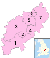
Northamptonshire, like most English counties, is divided into a number of local authorities. The seven borough/district councils cover 15 towns and hundreds of villages. The county has a two-tier structure of local government and an elected county council based in Northampton, and is also divided into seven districts each with their own district or borough councils:[31]
Northampton itself is the most populous urban district in England not to be administered as a unitary authority (even though several smaller districts are unitary). During the 1990s local government reform, Northampton Borough Council petitioned strongly for unitary status, which led to fractured relations with the County Council.
Before 1974, the Soke of Peterborough was considered geographically part of Northamptonshire, although it had had a separate county council since the late 1889 and separate courts of quarter sessions before then. Now part of Cambridgeshire, the city of Peterborough became a unitary authority in 1998, but it continues to form part of that county for ceremonial purposes.[32]
De facto bankruptcy
In early 2018, Northamptonshire County Council was declared technically insolvent and would be able to provide only the bare essential services.[33] According to The Guardian the problems were caused by "a reckless half-decade in which it refused to raise council tax to pay for the soaring costs of social care" and "partly due to past failings, the council is now having to make some drastic decisions to reduce services to a core offer." Some observers, such as Simon Edwards of the County Councils Network, added another perspective on the cause of the financial crisis, the United Kingdom government austerity programme: "It is clear that, partly due to past failings, the council is now having to make some drastic decisions to reduce services to a core offer. However, we can’t ignore that some of the underlying causes of the challenges facing Northamptonshire, such as dramatic reductions to council budgets and severe demand for services, mean county authorities across the country face funding pressures of £3.2bn over the next two years."[34]
Proposed structural changes
In early 2018, following the events above, Government-appointed commissioners took over control of the Council's affairs. Consequently, the Secretary of State for Housing, Communities and Local Government commissioned an independent report which, in March 2018, proposed structural changes to local government in Northamptonshire. These changes would see the existing county council and district councils abolished and two new unitary authorities created in their place. [35] One authority would consist of the existing districts of Daventry, Northampton and South Northamptonshire and the other authority would consist of Corby, East Northamptonshire, Kettering and Wellingborough districts. [36]
National representation
Northamptonshire returns seven members of Parliament, all of whom are currently from the Conservative Party.[37]
From 1993 until 2005, Northamptonshire County Council,[38] for which each of the 73 electoral divisions in the county elect a single councillor, had been held by the Labour Party; it had been under no overall control since 1981. The councils of the rural districts – Daventry, East Northamptonshire, and South Northamptonshire – are strongly Conservative, whereas the political composition of the urban districts is more mixed. At the 2003 local elections, Labour lost control of Kettering, Northampton, and Wellingborough, retaining only Corby. Elections for the entire County Council are held every four years – the last were held on 5 May 2005 when control of the County Council changed from the Labour Party to the Conservatives. The County Council uses a leader and cabinet executive system and abolished its area committees in April 2006.
Economy
Historically, Northamptonshire's main industry was manufacturing of boots and shoes.[39] Many of the manufacturers closed down in the Thatcher era which in turn left many county people unemployed. Although R Griggs and Co Ltd, the manufacturer of Dr. Martens, still has its UK base in Wollaston near Wellingborough,[40] the shoe industry in the county is now nearly gone. Large employers include the breakfast cereal manufacturers Weetabix, in Burton Latimer, the Carlsberg brewery in Northampton, Avon Products, Siemens, Barclaycard, Saxby Bros Ltd and Golden Wonder.[41][42] In the west of the county is the Daventry International Railfreight Terminal;[43] which is a major rail freight terminal located on the West Coast Main Line near Rugby. Wellingborough also has a smaller railfreight depot[44] on Finedon Road, called Nelisons sidings.[45]
This is a chart of trend of the regional gross value added of Northamptonshire at current basic prices in millions of British Pounds Sterling (correct on 21 December 2005):[46]
| Year | Regional Gross Value Added[47] | Agriculture[48] | Industry[49] | Services[50] |
|---|---|---|---|---|
| 1995 | 6,139 | 112 | 2,157 | 3,870 |
| 2000 | 9,743 | 79 | 3,035 | 6,630 |
| 2003 | 10,901 | 90 | 3,260 | 7,551 |
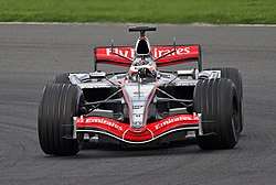
The region of Northamptonshire, Oxfordshire and the South Midlands has been described as "Motorsport Valley... a global hub" for the motor sport industry.[51][52] The Mercedes GP[53] and Force India[54] Formula One teams have their bases at Brackley and Silverstone respectively, while Cosworth[55] and Mercedes-Benz High Performance Engines[56] are also in the county at Northampton and Brixworth.
International motor racing takes place at Silverstone Circuit[57] and Rockingham Motor Speedway;[58] Santa Pod Raceway is just over the border in Bedfordshire but has a Northants postcode.[59] A study commissioned by Northamptonshire Enterprise Ltd (NEL) reported that Northamptonshire's motorsport sites attract more than 2.1 million visitors per year who spend a total of more than £131 million within the county.[60]
Milton Keynes and South Midlands Growth area
Northamptonshire forms part of the Milton Keynes and South Midlands Growth area which also includes Milton Keynes, Aylesbury Vale and Bedfordshire. This area has been identified as an area which is due to have tens of thousands additional homes built between 2010-2020. In North Northamptonshire (Boroughs of Corby, Kettering, Wellingborough and East Northants), over 52,000 homes are planned or newly built and 47,000 new jobs are also planned.[61] In West Northamptonshire (boroughs of Northampton, Daventry and South Northants), over 48,000 homes are planned or newly built and 37,000 new jobs are planned.[62] To oversee the planned developments, two urban regeneration companies have been created: North Northants Development Company (NNDC)[61] and the West Northamptonshire Development Corporation.[62] The NNDC launched a controversial[63] campaign called North Londonshire to attract people from London to the county.[64] There is also a county-wide tourism campaign with the slogan Northamptonshire, Let yourself grow.[65]
Education
Northamptonshire County Council operates a complete comprehensive system with 42 state secondary schools.[66] The county's music and performing arts trust provides peripatetic music teaching to schools. It also supports 15 local Saturday morning music and performing arts centres around the county and provides a range of county-level music groups.
Colleges
There are seven colleges across the county, with the Tresham College of Further and Higher Education having four campuses in three towns: Corby, Kettering and Wellingborough.[67] Tresham, which was taken over by Bedford College in 2017 due to failed Ofsted inspections, provides further education and offers vocational courses and re-sit GCSEs.[68] It also offers Higher Education options in conjunction with several universities.[69] Other colleges in the county are: Fletton House, Knuston Hall, Moulton College, Northampton College, Northampton New College and The East Northamptonshire College.
University
Northamptonshire has one university, the University of Northampton. It has two campuses 2.5 miles (4.0 km) apart and 10,000 students.[70] It offers courses for needs and interests from foundation and undergraduate level to postgraduate, professional and doctoral qualifications. Subjects include traditional arts, humanities and sciences subjects, as well as entrepreneurship, product design and advertising.[71]
Healthcare
Hospitals
Northampton has several National Health Service branches, the main acute NHS hospitals in the county being Northampton , Kettering General Hospital and Danetre Hospital in Daventry. In the south-west of the county, the towns of Brackley, Towcester and surrounding villages are serviced by the Horton General Hospital in Banbury in neighbouring Oxfordshire for acute medical needs. A similar arrangement is in place for the town of Oundle and nearby villages, served by Peterborough City Hospital.
In February 2011 a new satellite out-patient centre opened at Nene Park, Irthlingborough to provide over 40,000 appointments a year, as well as a minor injury unit to serve Eastern Northamptonshire. This was opened to relieve pressure off Kettering General Hospital, and has also replaced the dated Rushden Memorial Clinic which provided at the time about 8,000 appointments a year, when open.[72]
Water contamination
In June 2008, Anglian Water found traces of Cryptosporidium in water supplies of Northamptonshire. The local reservoir at Pitsford was investigated and a European rabbit which had strayed into it was found,[73] causing the problem. About 250,000 residents were affected;[74] by 14 July 2008, 13 cases of cryptosporidiosis attributed to water in Northampton had been reported.[75] Following the end of the investigation, Anglian Water lifted its boil notice for all affected areas on 4 July 2008.[76] Anglian Water revealed that it will pay up to £30 per household as compensation for customers hit by the water crisis.[77]
Transport
The gap in the hills at Watford Gap meant that many south-east to north-west routes passed through Northamptonshire. The Roman Road Watling Street (now part of the A5) passes through here, as did later canals, railways and major roads.
Roads
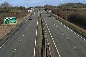
Major national roads including the M1 motorway (London to Leeds) and the A14 (Rugby to Felixstowe), provide Northamptonshire with transport links, both north–south and east–west. The A43 joins the M1 to the M40 motorway, passing through the south of the county to the junction west of Brackley, and the A45 links Northampton with Wellingborough and Peterborough.
The county road network, managed by Northamptonshire County Council includes the A45 west of the M1 motorway, the A43 between Northampton and the county boundary near Stamford, the A361 between Kilsby and Banbury (Oxon) and all B, C and Unclassified Roads. Since 2009 these highways have been managed on behalf of the county council by MGWSP, a joint venture between May Gurney and WSP.
Rivers and canals
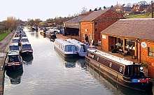
Two major canals – the Oxford and the Grand Union – join in the county at Braunston. Notable features include a flight of 17 locks on the Grand Union at Rothersthorpe, the canal museum at Stoke Bruerne, and a tunnel at Blisworth which, at 2,813 metres (3,076 yd), is the third-longest navigable canal tunnel on the UK canal network.
A branch of the Grand Union Canal connects to the River Nene in Northampton and has been upgraded to a "wide canal" in places and is known as the Nene Navigation. It is famous for its guillotine locks.
Railways
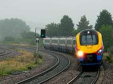
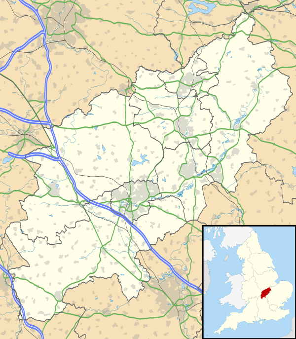
Two trunk railway routes, the Midland Main Line and the West Coast Main Line, cross the county. At its peak, Northamptonshire had 75 railway stations. It now has only six, at Northampton and Long Buckby on the West Coast Main Line, Kettering, Wellingborough and Corby on the Midland Main Line, along with King's Sutton, only a few yards from the boundary with Oxfordshire on the Chiltern Main Line.
Before nationalisation of the railways in 1948 and the creation of British Railways, three of the "Big Four" railway companies operated in Northamptonshire: the London, Midland and Scottish Railway, London and North Eastern Railway and Great Western Railway. Only the Southern Railway was not represented. As of 2018, it is served by Chiltern Railways and East Midlands Trains, Virgin Trains and West Midlands Trains.
- Corby rail history
Corby was described as the largest town in Britain without a railway station.[78] The railway running through the town from Kettering to Oakham in Rutland was previously used only by freight traffic and occasional diverted passenger trains that did not stop at the station. The line through Corby was once part of a main line to Nottingham through Melton Mowbray, but the stretch between Melton and Nottingham was closed in 1968. In the 1980s, an experimental passenger shuttle service ran between Corby and Kettering but was withdrawn a few years later.[79] On 23 February 2009, a new railway station opened, providing direct hourly access to London St Pancras. Following the opening of Corby Station, Rushden then became the largest town in the United Kingdom without a direct railway station.
- Closed lines and stations
Railway services in Northamptonshire were reduced by the Beeching cuts in the 1960s.[80] Closure of the line connecting Northampton to Peterborough by way of Wellingborough, Thrapston, and Oundle left eastern Northamptonshire devoid of railways. Part of this route was reopened in 1977 as the Nene Valley Railway. A section of one of the closed lines, the Northampton to Market Harborough line, is now the Northampton & Lamport heritage railway, while the route as a whole forms a part of the National Cycle Network, as the Brampton Valley Way.
As early as 1897 Northamptonshire would have had its own Channel Tunnel rail link with the creation of the Great Central Railway, which was intended to connect to a tunnel under the English Channel. Although the complete project never came to fruition, the rail link through Northamptonshire was constructed, and had stations at Charwelton, Woodford Halse, Helmdon and Brackley. It became part of the London and North Eastern Railway in 1923 (and of British Railways in 1948) before its closure in 1966.
- Future
In June 2009 the Association of Train Operating Companies (ATOC) recommended opening a new station on the former Irchester railway station site for Rushden, Higham Ferrers and Irchester, called Rushden Parkway.[81] Network Rail is looking at electrifying the Midland Main Line north of Bedford.[82] An open access company has approached Network Rail for services to Oakham in Rutland to London via the county.[82]
The Rushden, Higham and Wellingborough Railway would like to see the railway fully reopen between Wellingborough and Higham Ferrers. As part of the government-proposed High Speed 2 railway line (between London and Birmingham), the high-speed railway will go through the southern part of the county but with no station built.
Buses

Most buses are operated by Stagecoach Midlands. Some town area routes have been named the Corby Star, Connect Kettering, Connect Wellingborough and Daventry Dart; the last three of these routes have route designations that include a letter (such as A, D1, W1, W2).
Airports
Sywell Aerodrome, on the edge of Sywell village, has three grass runways and one concrete all-weather runway. It is, however, only 1000 metres long and therefore cannot be served by passenger jets.[83]
Media
Newspapers
The three main newspapers in the county are the Northampton Herald & Post, the Northamptonshire Evening Telegraph and the Northampton Chronicle & Echo.
Television
- BBC regions
Most of Northamptonshire is served by the BBC's East region which is based in Norwich. The regional news television programme, BBC Look East, provides local news across the East of England, Milton Keynes and most of Northamptonshire. An opt-out in Look East covers the west part of the region only, broadcast from Cambridge. This area also is covered by the BBC's The Politics Show: East and Inside Out: East. A small part of the north of the county is covered by BBC East Midlands's regional news BBC East Midlands Today, while a small part of South Northamptonshire is covered by BBC Oxford's regional news BBC Oxford News which is part of the BBC South Today programme.
- ITV regions
Most of Northamptonshire is covered by ITV's Anglia region (which broadcasts Anglia Today/Tonight); in the south-west of the county, primarily Brackley and the surrounding villages, broadcasts can be received from the Oxford transmitter which broadcasts ITV Meridian's Meridian Today/Tonight.
Radio
BBC Radio Northampton, broadcasts on two FM frequencies: 104.2 MHz for the south and west of the county (including Northampton and surrounding area) and 103.6 MHz for the north of the county (including Kettering, Wellingborough and Corby). BBC Radio Northampton is situated on Abington Street, Northampton. These services are broadcast from the Moulton Park & Geddington transmitters.
There are three commercial radio stations in the county. The former Kettering and Corby Broadcasting Company (KCBC) station is now called Connect Radio (97.2 and 107.4 MHZ FM), following a merger with the Wellingborough-based station of the same name. While both Heart Northants (96.6 MHz FM) and AM station Smooth Northants (1557 kHz) air very little local content as they form part of a national network. National digital radio is also available in Northamptonshire, though coverage is limited.
Corby is served by its own dedicated station, Corby Radio (96.3fm), based in the town and focused on local content.[84]
Sport
Rugby union
Northamptonshire has many rugby union clubs. Its premier team Northampton Saints, competes in the Aviva Premiership and won the European championship in 2000 by defeating Munster for the Heineken Cup, 9-8. Saints are based at the 15,249 capacity [85] Franklin's Gardens ground. In 2014 the club won the Aviva Premiership as well as the Challenge Cup. For the 2014/15 campaign the team finished top of the table for the first time in the premiership, eventually losing 24-29 to Saracens in the playoff semi-final.
Association football
Northamptonshire has twenty four football clubs operating in the top ten levels of the English football league system. The sport in the area is administered by the Northamptonshire County Football Association, which is affiliated with the United Counties League, the Northamptonshire Combination Football League, the Northampton Town Football League, as well as the Peterborough and District Football League in neighbouring Cambridgeshire. Only two clubs in Northamptonshire have competed in The Football League - Northampton Town and the defunct Rushden & Diamonds.
Northampton Town F.C.
The most prominent Association Football club in the county is League Two side Northampton Town, which attracts between 4,000-6,000 fans on an average game day and has been part of the Football League since 1923.[86] Their home ground is Sixfields Stadium which in 1994. The first match there took place on 15 October against Barnet Football Club. The stadium can hold up to 7,500 people, with provisions for the disabled.[87] The club's most successful period occurred between 1962-67 when it progressed from Fourth Division to First Division, before falling back to the bottom of Fourth Division again by 1974. The club has reached the 5th round of the FA Cup on 3 occasions, the last being in 1970. The 4th round was last reached in 2004.[86] Recently, the Cobblers were promoted back to League 1 on 9 April 2016. The week after that, they secured the club's first title for 29 years by winning league 2 after a 0-0 draw at Exeter City.[88] The most goals in a career was performed by the player, Jack English in 1947-59 with 143 goals out of 321 matches.[89]
Semi-professional clubs
Because Northamptonshire is located near the centre of England, many of its clubs end up being swapped around between Northern and Southern-based leagues.
Level 6
- Brackley Town - National League North - average attendance 427
Level 7
- Kettering Town - Southern Football League - Premier Division - average attendance 502
Level 8
- AFC Rushden & Diamonds - Southern Football League - Division One, East - average attendance 466
- Corby Town F.C. - Northern Premier League - Division One, South - average attendance 473
United Counties League
Nineteen teams compete in the United Counties League (UCL), a league operating at levels 9 and 10 of the English League system, and which encompasses all of Northamptonshire and parts of neighbouring counties. Prominent at this level in recent years (2011-2015) has been AFC Rushden & Diamonds, a "Phoenix Club" created and owned by supporters of the now defunct Rushden & Diamonds F.C. which, in its heyday, fielded a fully professional team at the third level of the English League system. About 550 have attended AFC Rushden and Diamond home matches in recent years,[90] dwarfing attendances from other clubs. Another prominent club at this level is Wellingborough Town, who once competed in the Southern Football League[91] and has an average match attendance of 122[90]
Other clubs in the UCL are Bugbrooke St Michaels F.C., Burton Park Wanderers F.C., Cogenhoe United F.C., Desborough Town F.C., Irchester United F.C., Long Buckby A.F.C., Northampton ON Chenecks F.C., Northampton Sileby Rangers F.C., Northampton Spencer F.C., Raunds Town F.C., Rothwell Corinthians F.C., Rothwell Town F.C., Rushden & Higham United F.C., Stewarts & Lloyds Corby A.F.C., Thrapston Town F.C., Wellingborough Whitworth F.C. and Woodford United F.C.
Cricket
Northamptonshire County Cricket Club (also known as The Steelbacks) is in Division Two of the County Championship, and play their home games at the County Cricket Ground, Northampton. They finished as runners-up in the Championship on four occasions in the period before it split into two divisions.
In 2013 the club won the Friends Life t20, beating Surrey in the final. Appearing in their 3rd final in 4 years, the Steelbacks to beat Durham by 4 wickets at Edgbaston in 2016 to lift the Natwest t20 Blast trophy for the second time. It also won the NatWest Trophy on two occasions and the Benson & Hedges Cup once.
Motor sport
Silverstone is a major motor racing circuit, most notably used for the British Grand Prix. There is also a dedicated radio station for the circuit which broadcasts on 87.7 FM or 1602 MW when events are taking place. However, part of the circuit is across the border in Buckinghamshire. Rockingham Speedway Corby is the largest stadium in the United Kingdom with 130,000 seats. It is a US-style elliptical racing circuit (the largest of its kind outside of the United States), and is used extensively for all kinds of motor racing events. The Santa Pod drag racing circuit, venue for the FIA European Drag Racing Championships is just across the border in Bedfordshire but has a NN postcode. Cosworth the high-performance engineering company is based in Northampton.
Two Formula One teams are based in Northamptonshire, with Mercedes at Brackley and Force India in Silverstone. Force India also have a secondary facility in Brackley, while Mercedes build engines for themselves, Force India and Williams at Brixworth.
Swimming and diving
There are seven competitive swimming clubs in the county: Northampton Swimming Club, Wellingborough Amateur Swimming Club, Rushden Swimming Club, Kettering Amateur Swimming Club, Corby Amateur Swimming Club, Daventry Dolphins Swimming Club, and Nene Valley Swimming Club. There is also one diving club: Corby Steel Diving Club. The main pool in the county is Corby East Midlands International Pool, which has an 8-lane 50m swimming pool with a floor that can adjust in depth to provide a 25m pool. The pool is home to the Northamptonshire Amateur Association's County Championships as well as some of the Youth Midland Championships.[92][93]
Northamptonshire is home to 2016 paralympian, Ellie Robinson. She was talent-spotted in July 2012 and developed at Northampton Swimming club, and was selected to compete for Great Britain at the 2016 IPC Swimming European Championships. It was here she won three bronze and one silver medal.[94]
Culture
Jane Austen set her 1814 novel Mansfield Park mostly in Northamptonshire.
Rock and pop bands originating in the area have included Bauhaus, Temples, The Departure, New Cassettes, Raging Speedhorn and Defenestration.
Kinky Boots, the 2005 British-American film and subsequent stage musical adaptation, was based on the true story of a traditional Northamptonshire shoe factory which, to stay afloat, entered the market for fetish footwear.
Richard Coles, an English musician, partnered in the 1980s with Jimmy Somerville to create The Communards band. They made three Top Ten Hits and made the Number 1 record in 1986 with their song 'Don't Leave me this way'. In 2012, The University of Northampton awarded him an honorary doctorate. He is now the vicar of Finedon in Northamptonshire.
Places of interest
| Key | |
| Abbey/Priory/Cathedral | |
| Accessible open space | |
| Amusement/Theme Park | |
| Castle | |
| Country Park | |
| English Heritage | |
| Forestry Commission | |
| Heritage railway | |
| Historic House | |
| Museum (free/not free) | |
| National Trust | |
| Theatre | |
| Zoo | |
- 78 Derngate
.png)
- Althorp

- Barnwell Country Park

- Barnwell Manor
- Billing Aquadrome
- Borough Hill Daventry (Iron Age hill fort)

- Boughton House (home of the Dukes of Buccleuch)
- Blisworth tunnel
- Brackley
- Brampton Valley Way (linear park on a disused railway line)
- Brixworth Country Park
- Burghley House (in the Soke of Peterborough, so formerly in Northants),
- Canons Ashby House

- Castle Ashby (home of the Marquess of Northampton),
- Coton Manor Garden
- Cottesbrooke Hall
- Daventry Country Park
- Deene Park
- Delapré Abbey
- Derngate and Royal Theatre
- Easton Neston
- Fermyn Woods Country Park
- Fotheringhay Castle & Church
- Franklin's Gardens
- Geddington's Eleanor cross
- Holdenby House
- Irchester Country Park
- Jurassic Way (long-distance footpath)
- Kelmarsh Hall
- Kirby Hall

- Knuston Hall
- Lamport Hall
- Lilford Hall
- Lyveden New Bield
- Pitsford Reservoir
- Prebendal Manor House, Nassington
- Naseby Field
- Northampton Cathedral
- Northampton & Lamport Railway

- Northamptonshire Ironstone Railway
- Roadmender - live music venue
- Piddington Roman Villa
- Rockingham Castle
- Rockingham Forest

- Rockingham Motor Speedway
- Rushden Hall
- Rushden, Higham and Wellingborough Railway
- Rushden Station Railway Museum
- Rushton Triangular Lodge
- Salcey Forest
- Silverstone Circuit
- Southwick Hall
- Stanwick Lakes
- Stoke Bruerne Canal Museum
- Sulgrave Manor
- Summer Leys nature reserve
- Syresham
- Sywell Country Park
- The Castle Theatre
- Towcester Museum
- Watford Locks
- Wellingborough Museum

- Whittlewood Forest
- Wicksteed Park

Annual events
- Gretton Barn dance
- British Grand Prix at Silverstone
- Burghley Horse Trials
- Crick Boat Show
- Hollowell Steam Rally
- Northampton Balloon Festival
- Rothwell Fair
- Rushden Cavalcade
- St Crispin Street Fair
- Wellingborough Carnival
- World Conker Championships
- Buckby Feast
- Corby Highland Gathering
See also
- Grade I listed buildings in Northamptonshire
- List of Lord Lieutenants of Northamptonshire
- List of High Sheriffs of Northamptonshire
- Custos Rotulorum of Northamptonshire - List of Keepers of the Rolls
- Northamptonshire (UK Parliament constituency) - Historical list of MPs for the Northamptonshire constituency
- List of places in Northamptonshire
- History of Northamptonshire
- Northamptonshire Police
- Northamptonshire Police and Crime Commissioner
- East Midlands
- South Midlands
- Category:People from Northamptonshire
Notes
- ↑
Or: ROSA CONCORDIAE SIGNUM - compare:
Young, Robert (ed.). "Northamptonshire". Civic Heraldry of England and Wales. Retrieved 2017-04-18.
ROSA CONCORDIAE SIGNUM'
- ↑ "HM Lord-Lieutenant of Northamptonshire". Northamptonshire County Council. Archived from the original on 13 May 2016. Retrieved 19 April 2016.
- ↑ "No. 62229". The London Gazette. 15 March 2018. pp. 4814–4814.
- ↑ "Lincolnshire County Council". Thebythams.org.uk. 24 October 2005. Retrieved 25 September 2010.
- ↑ "Plant and fungi species: Cowslip". Plantlife.org.uk. Retrieved 5 November 2017.
- ↑ Greenall (1979) p.19
- 1 2 3 4 Greenall (1979) p.20
- ↑ BBC - History - Tribes of Britain. Retrieved 16 August 2009. Archived 25 August 2009 at the Wayback Machine.
- ↑ Greenall (1979) p.29
- ↑ Wood, Michael (1986) The Domesday Quest p. 90, BBC Books, 1986 ISBN 0-563-52274-7.
- ↑ Mills, A.D. (1998). A Dictionary of English Place-names. Second Edition. Oxford University Press, Oxford. p256. ISBN 0-19-280074-4
- ↑ "Rockingham Castle - Rockingham Castle, a home of history, Weddings, Corporate events and the Rockingham International Horse Trials". Rockinghamcastle.com. Retrieved 20 January 2018.
- ↑ Stearns, Peter N., Langer. William L. The Encyclopedia of world history: ancient, medieval, and modern. Retrieved 16 August 2009.
- ↑ Mott, Allan. BBC - Cambridgeshire - History: Mary Queen of Scots' last days. Bbc.co.uk, Retrieved 16 August 2009.
- ↑ The Writings of George Washington: Life of Washington. Retrieved 16 August 2009.
- ↑ Edmonds. 1848. Notes on English history for the use of juvenile pupils. Retrieved 16 August 2009.
- ↑ Brookes, R., Whittaker, W.B. The General Gazetteer, or, Compendious geographical dictionary, in miniature. 1823. Retrieved 5 September 2009.
- ↑ Malte-Brun, C. Universal geography: or, A description of all parts of the world. 1832. Retrieved 5 September 2009.
- ↑ Andrews, R., Teller, M. The Rough Guide to Britain 2004. Rough Guides. Retrieved 5 September 2009.
- ↑ GENUKI: Northamptonshire Genealogy: Bartholomew's Gazetteer of the British Isles, 1887. Kellner.eclipse.co.uk, 11 August 2008. Retrieved 5 September 2009.
- ↑ "English Partnerships - Corby". Web.archive.org. 23 June 2004. Archived from the original on 23 June 2004. Retrieved 20 January 2018.
- ↑ "English Partnerships - Northampton". Web.archive.org. 12 December 2004. Archived from the original on 12 December 2004. Retrieved 20 January 2018.
- ↑ "Northamptonshire Chamber :: Milton Keynes & South Midlands Growth Plan". Web.archive.org. 7 December 2009. Archived from the original on 7 December 2009. Retrieved 20 January 2018.
- ↑ "Peterborough Diocesan Registry". Peterboroughdiocesanregistry.co.uk. Retrieved 20 January 2018.
- ↑ The Huntingdon and Peterborough Order 1964 (SI 1964/367), see Local Government Commission for England (1958-1967), Report and Proposals for the East Midlands General Review Area (Report No.3), 31 July 1961 and Report and Proposals for the Lincolnshire and East Anglia General Review Area (Report No.9), 7 May 1965
- ↑ The English Non-metropolitan Districts (Definition) Order 1972 (SI 1972/2039) Part 5: County of Cambridgeshire
- ↑ "Archived copy". Archived from the original on 12 March 2007. Retrieved 6 February 2016.
- ↑ UK Genealogy Archives: Transcript from Pigot & Co's Commercial Directory, 1830. Retrieved 15 August 2009.
- ↑ Northamptonshire Genealogy: Bartholomew's Gazetteer of the British Isles, 1887. Retrieved 15 August 2009.
- ↑ "Average weather for Northamptonshire (Moulton weather station)". Weather.msn.com.
- ↑ Northamptonshire County Council: District and Borough Councils Archived 26 September 2009 at the Wayback Machine.. 2008. Retrieved 22 August 2009.
- ↑ The Cambridgeshire (City of Peterborough) (Structural, Boundary and Electoral Changes) Order 1996 (SI 1996/1878), see Local Government Commission for England (1992), Final Recommendations for the Future Local Government of Cambridgeshire, October 1994 and Final Recommendations on the Future Local Government of Basildon & Thurrock, Blackburn & Blackpool, Broxtowe, Gedling & Rushcliffe, Dartford & Gravesham, Gillingham & Rochester upon Medway, Exeter, Gloucester, Halton & Warrington, Huntingdonshire & Peterborough, Northampton, Norwich, Spelthorne and the Wrekin, December 1995
- ↑ Johnston, Neil (2 August 2018). "'Bankrupt' Northamptonshire county council may cut to legal minimum". The Times. Retrieved 9 September.
Hundreds of jobs are also at risk
Check date values in:|access-date=(help) - ↑ Butler, Patrick (1 August 2018). "Northamptonshire's cash crisis driven by ideological folly, councillors told". The Guardian. Retrieved 9 September. Check date values in:
|access-date=(help) - ↑ https://www.bbc.co.uk/news/uk-england-northamptonshire-40610349
- ↑ http://www.itv.com/news/anglia/2018-03-15/northamptonshire-county-council-should-be-split-up-finds-damning-report/
- ↑ "Regional MPs & Local Authority Links". Northamptonshire Chamber. Retrieved 16 August 2018.
- ↑ "Northamptonshire County Council website". Retrieved 4 June 2009.
- ↑ GENUKI: Northamptonshire Genealogy: Bartholomew's Gazetteer of the British Isles. 1887. Retrieved 22 August 2009.
- ↑ Kellysearch.co.uk: R Griggs & Co. Ltd Archived 11 January 2012 at the Wayback Machine.. Retrieved 22 August 2009.
- ↑ "Northamptonshire Chamber :: Major Northamptonshire employers". Web.archive.org. 26 June 2010. Archived from the original on 26 June 2010. Retrieved 20 January 2018.
- ↑ "Archived copy" (PDF). Archived from the original (PDF) on 15 June 2011. Retrieved 5 September 2009.
- ↑ "Archived copy". Archived from the original on 26 January 2009. Retrieved 10 August 2009.
- ↑ FirstGBRf: FirstGBRf opens unique depot at Wellingborough. 12 June 2007. Retrieved 22 August 2009.
- ↑ GB Railfreight: Locations, Wellingborough Retrieved 11 November 2010
- ↑ Regional Gross Value Added.Office for National Statistics Archived 28 July 2011 at the Wayback Machine.. pp 240–253. 21 December 2005. Retrieved 22 August 2009.
- ↑ Components may not sum to totals due to rounding
- ↑ includes hunting and forestry
- ↑ includes energy and construction
- ↑ includes financial intermediation services indirectly measured
- ↑ Coe, N.M., Kelly, P.F, Wai-Chung Yeung, H. Economic geography: a contemporary introduction. Wiley-Blackwell, 2007. pp 141-143. Retrieved 22 August 2009.
- ↑ Russell Hotten. Motor racing battles to stay out of pits. TimesOnline. 27 March 2009. Retrieved 22 August 2009.
- ↑ Official site of Mercedes GP Formula One Team: Contact us. Mercedes-gp.com, Retrieved 4 March 2010.
- ↑ Force India F1 Team: Contact us Archived 1 September 2009 at the Wayback Machine.. Forceindiaf1.com, Retrieved 22 August 2009.
- ↑ Cosworth: Contact Archived 20 June 2009 at the Wayback Machine.. Cosworth.com, Retrieved 22 August 2009.
- ↑ Mercedes-Benz High Performance Engines Ltd: Contact. Mercedes-benz-hpe.com, Retrieved 22 August 2009.
- ↑ Silverstone Official Website: Contact Numbers Archived 30 April 2009 at the Wayback Machine.. Retrieved 22 August 2009.
- ↑ Getting to Rockingham Archived 3 February 2009 at the Wayback Machine.. Rockingham.co.uk, Retrieved 22 August 2009.
- ↑ Santa Pod Raceway: Contact/find us/postcode. Santapod.co.uk, Retrieved 22 August 2009.
- ↑ Motorsport to grow 30% in next decade. Northants Evening Telegraph. 25 June 2009. Retrieved 22 August 2009.
- 1 2 MSKM: North Northants Archived 23 July 2011 at the Wayback Machine. Mksm.org.uk, Accessed 2 October 2010
- 1 2 MKSM: West Northants Archived 23 July 2011 at the Wayback Machine. Mksm.org.uk, Accessed 2 October 2010
- ↑ Come to North Londonshire Northants Evening Telegraph, Accessed 2 October 2010
- ↑ North Londonshire: home page Accessed 2 October 2010
- ↑ Let yourself grow: home page Letyourselfgrow.com, Accessed 2 October 2010
- ↑ Northamptonshire County Council: Northamptonshire Schools Directory Archived 21 July 2012 at the Wayback Machine.. Retrieved 8 August 2009.
- ↑ Tresham College: Our Campuses Archived 29 October 2009 at the Wayback Machine.. Retrieved 8 August 2009.
- ↑ . Retrieved 15 April 2018.
- ↑ Tresham College: Higher Education Archived 19 May 2009 at the Wayback Machine.. Retrieved 8 August 2009.
- ↑ The University of Northampton: About Us. Retrieved 8 August 2009.
- ↑ The University of Northampton: Course finder. Retrieved 8 August 2009.
- ↑ "New £4.2m Irthlingborough outpatients clinic opens". BBC News. 7 February 2011. Retrieved 7 February 2011.
- ↑ Tite, Nick (14 July 2008). "Rabbit caused water contamination at Pitsford - Northants ET". Northants Evening Telegraph. Retrieved 22 August 2008.
- ↑ "Sickness bug found in tap water". BBC. 25 June 2008. Retrieved 15 July 2008.
- ↑ "BBC News". News at Ten, BBC One. BBC. 14 July 2008.
- ↑ "Anglian Water" Archived 28 September 2011 at the Wayback Machine., Press Release
- ↑ "Water crisis: All clear for tap water - and up to £30 compensation! - Northampton Chronicle and Echo". Chronicle & Echo. 5 July 2008. Retrieved 22 August 2008.
- ↑ Britten, Nick (23 February 2009). "Corby station". London: Telegraph.co.uk. Retrieved 25 September 2010.
- ↑ Network South East routes Archived 7 January 2009 at the Wayback Machine.
- ↑ "SMJR". Smjr.info. 19 September 2010. Archived from the original on 11 December 2008. Retrieved 25 September 2010.
- ↑ "Connecting Communities – Expanding Access to the Rail Network" (PDF). London: Association of Train Operating Companies. June 2009. p. 19. Retrieved 7 September 2018.
- 1 2 Network Rail: East Midlands Draft Route Utilisation Strategy Access date: 4 January 2010
- ↑
- ↑ "The Corby Radio Story". corbyradio.com. Archived from the original on 7 March 2016. Retrieved 5 March 2016.
- ↑ "A New Dawn". Northamptonsaints.co.uk. Retrieved 5 November 2017.
- 1 2 "Northampton Town FC". Retrieved 4 May 2015.
- ↑ "Sixfields Stadium - Northampton Town". Ntfc.co.uk. Archived from the original on 11 March 2017. Retrieved 5 November 2017.
- ↑ "Club history - Northampton Town". Ntfc.co.uk. Retrieved 5 November 2017.
- ↑ "Club records - Northampton Town". Ntfc.co.uk. Retrieved 5 November 2017.
- 1 2 "Home Attendances". Thelinnets.co.uk. Retrieved 4 May 2015.
- ↑ "Wellingborough Town". Fchd.info. Retrieved 4 May 2015.
- ↑ "Northants ASA". northantsasa.org.
- ↑ "Midland Championships". midlandchampionships.org.uk. Archived from the original on 6 June 2014. Retrieved 12 July 2014.
- ↑ "Ellie Robinson". Rio.paralympics.org.uk. Retrieved 5 November 2017.
References
- Greenall, R. L. (1979) A History of Northamptonshire Phillimore & Co. Ltd. ISBN 1-86077-147-5.
External links
| Wikimedia Commons has media related to Northamptonshire. |
- Northamptonshire County Council
- Northamptonshire at Curlie (based on DMOZ)
- 1894/5 description
- Local Theatre in Northamptonshire
- Northamptonshire History Website
- Northamptonshire Tourism Website
- Northamptonshire Guide Website
- Visit Northamptonshire Website
- Northamptonshire Online Forum
- Images of Northamptonshire at the English Heritage Archive
Neighbouring counties | |
|---|---|
Northamptonshire Portal | |
| Boroughs or districts | |
| Major settlements | |
| Rivers | |
| Canals | |
| Topics | |