List of postcode areas in the United Kingdom
The list of postcode areas in the United Kingdom is a tabulation of the postcode areas used by Royal Mail for the purposes of directing mail within the United Kingdom. The postcode area is the largest geographical unit used and forms the initial characters of the alphanumeric UK postcode.[1] There are currently 121 geographic postcode areas in use in the UK and a further 3 often combined with these covering the Crown Dependencies of Guernsey, Jersey and Isle of Man.
Subdivision
Each postcode area is further divided into post towns and postcode districts.[1] There are on average 20 postcode districts to a postcode area.[1] The London post town is instead divided into several postcode areas.[2]
Scope
The single or pair of letters chosen for postcode areas are generally intended as a mnemonic for the places served.[1] Postcode areas, post towns and postcode districts do not follow political boundaries and usually serve much larger areas than the place names with which they are associated. For example, within the PA postcode area the PA1 and PA78 postcode districts are 140 miles apart; and the eight postcode areas of the London post town cover only 40% of Greater London.[2] The remainder of its area is covered by sections of twelve adjoining postcode areas: EN, IG, RM, DA, BR, TN, CR, SM, KT, TW, HA and UB.[2]
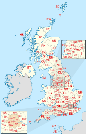
United Kingdom postcode areas
Crown dependencies
The Crown dependencies (which are not part of the United Kingdom) did not introduce postcodes until later, but use a similar coding scheme. They are separate postal authorities.[1]
| Postcode area | Postcode area name |
|---|---|
| GY | Guernsey |
| JE | Jersey |
| IM | Isle of Man |
Defunct postcode areas
London NE and S
Glasgow
Glasgow, like London, was divided into compass districts: C, W, NW, N, E, SE, S, SW. When postcodes were introduced, these were mapped into the new G postcode: C1 became G1, W1 became G11, N1 became G21, E1 became G31, S1 became G41, SW1 became G51, and so on. As NW and SE had never been subdivided they became G20 and G40 respectively.
Norwich and Croydon
Norwich and Croydon were used for a postcode experiment in the late 1960s, which was replaced by the current system. The format was of the form NOR or CRO followed by two numbers and a letter, e.g. NOR 07A.
Non-geographic postcodes
Note that a number of non-geographic postcode sectors are also contained within geographic postcode areas.
GIR
GIR 0AA is a postcode created for Girobank in Bootle. It remained in use by its successors when Girobank was taken over by Alliance & Leicester and subsequently by Santander UK.
BF
The BF postcode area was introduced in 2012 to provide optional postcodes for British Forces Post Office addresses, for consistency with the layout of other UK addresses. It uses the national non-geographic post town "BFPO" and, as of 2012, the postcode district "BF1".
BX
The non-geographic postcode area BX has been introduced for addresses which do not include a locality: this allows large organisations long-term flexibility as to where they receive their mail. This postcode area is used by Lloyds Banking Group (BX1 1LT) and parts of the HM Revenue and Customs like VAT Central Unit (BX5 5AT) and Pay as You Earn (BX9 1AS). Lloyds Bank also use BX4. After splitting from Lloyds, TSB Bank uses BX4 7SB, the latter part of which, when written, looks similar to "TSB".
QC
QC postcodes are used by awarding bodies when receiving examination scripts from centres via Parcelforce. For example, Edexcel use the postcode QC77 7ZZ.
XX
The non-geographic postcode area XX is used by online retailers for returns by Royal Mail.
| Retailer | XX Postcodes |
|---|---|
| Amazon.com | XX10 1DD (Scottish Distribution Centre)[8] XX50 1DD (ditto) XX30 1FF (South West Distribution Centre) |
| ASOS.com | XX10 1AA |
| Boohoo.com | XX10 1BB |
| John Lewis | XX10 1EE |
Overseas territories
Certain British overseas territories have postcodes:
| Postcode | Location |
|---|---|
| AI-2640 | Anguilla[9] |
ASCN 1ZZ STHL 1ZZ TDCU 1ZZ | Saint Helena, Ascension and Tristan da Cunha: Ascension Island Saint Helena Tristan da Cunha[10] |
| BBND 1ZZ | British Indian Ocean Territory |
| BIQQ 1ZZ | British Antarctic Territory |
| FIQQ 1ZZ | Falkland Islands |
| GX11 1AA | Gibraltar |
| PCRN 1ZZ | Pitcairn Islands |
| SIQQ 1ZZ | South Georgia and the South Sandwich Islands |
| TKCA 1ZZ | Turks and Caicos Islands[11] |
| BFPO 57 / BF1 2AT(Akrotiri) BFPO 58 / BF1 2AU (Dhekelia) | Akrotiri and Dhekelia |
| List | Bermuda |
| List | Cayman Islands |
| List | British Virgin Islands |
| List | Montserrat |
These were introduced to prevent mail being sent to the wrong place, e.g., for St Helena to St Helens, Merseyside[12] and Ascension Island to Asunción, Paraguay, and many on-line companies will not accept addresses lacking a postcode. Such mail is treated as international, not inland, so sufficient postage must be used.
See also
References
- 1 2 3 4 5 6 7 8 9 10 11 12 13 14 15 16 17 18 19 Address Management Guide (5th ed.). Royal Mail Group plc. March 2007. Archived from the original on 8 November 2012. Retrieved 22 October 2012.
- 1 2 3 HMSO, The Inner London Letter Post, (1980)
- ↑ Office for National Statistics (1999). The Official Yearbook of the United Kingdom (PDF) (2000 ed.). London: The Stationery Office. "UK Postal Areas", map opposite p. 5. ISBN 0-11-621098-2. Archived (PDF) from the original on 30 October 2012. Retrieved 22 October 2012.
- 1 2 "Postcodes in the UK - Jonathan Rawle's Website". jonathan.rawle.org. Archived from the original on 29 April 2018. Retrieved 29 April 2018.
- ↑ "Quarterly Quality of Service Report to Postcomm – 2009/10 Quarter 1 Report" (PDF). Royal Mail. 2009-08-20. pp. 4&ndash, 8 (table 2). Retrieved 2009-11-06.
- ↑ Manger, Warren (26 August 2014). "40 facts about the postcode to mark 40th anniversary as vital part of daily life". mirror.co.uk. mirror.co.uk. Archived from the original on 16 March 2018. Retrieved 16 March 2018.
- ↑ "History of the UK Postcode - Modern Origin". postcodearea.co.uk. postcodearea.co.uk. Archived from the original on 18 October 2017. Retrieved 16 March 2018.
- ↑ Amazon Help [@AmazonHelp] (24 October 2016). "@MarkWickson This postcode is a non-geographic code used by us for returns carried by Royal Mail to our returns center Dunfermline, SCT. ^SW" (Tweet) – via Twitter.
- ↑ "Anguilla Has A Postal Code, AI-2640", The Anguillian, 12 October 2007
- ↑ First postcode for remote UK isle Archived 2008-12-24 at the Wayback Machine.. BBC News. 7 August 2005.
- ↑ Turks and Caicos Islands. Bureau International UPU.
- ↑ Landmark birthday for postcode
External links
Postcode area boundaries:
- Office for National Statistics - Postal geography
- OpenStreetMap - Postcode map
- Strowger net: postcodes of the UK
- UK Business Lists - Map of UK Postcodes
- Direct Marketing Lists UK postcode map
- Business Lists UK postcode map
- FREE Vector UK Postcode Maps
- PostcodeArea - Demographics, maps, crime rates, house prices and local information for all UK postcodes
- Strange Maps - Frank Jacobs - Diagrammatic Map