L postcode area
Postcode district boundaries:
| Liverpool postcode area | |
|---|---|
 L | |
| Postcode area | L |
| Postcode area name | Liverpool |
| Post towns | 4 |
| Postcode districts | 65 |
| Postcode sectors | 581 |
| Postcodes (live) | 20,322 |
| Postcodes (total) | 42,024 |
| Statistics as at February 2012[1] | |
The L postcode area, also known as the Liverpool postcode area,[2] is a group of postcode districts in Merseyside, Cheshire and Lancashire, specifically around Liverpool in England and including Bootle, Ormskirk and Prescot. In 1999, postcodes for the Wirral Peninsula (L41–49, L60–66) were transferred from L to the CH postcode area.[3]
Coverage
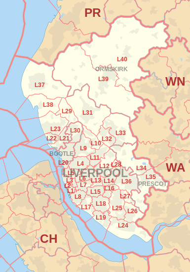
The approximate coverage of the postcode districts:
| Postcode district | Post town | Coverage | Local authority area |
|---|---|---|---|
| L1 | LIVERPOOL | City Centre | Liverpool |
| L2 | LIVERPOOL | City Centre | Liverpool |
| L3 | LIVERPOOL | City Centre, Everton, Vauxhall | Liverpool |
| L4 | LIVERPOOL | Anfield, Kirkdale, Walton | Liverpool |
| L5 | LIVERPOOL | Anfield, Everton, Kirkdale, Vauxhall | Liverpool |
| L6 | LIVERPOOL | Anfield, City Centre, Everton, Fairfield, Kensington, Tuebrook | Liverpool |
| L7 | LIVERPOOL | City Centre, Edge Hill, Fairfield, Kensington | Liverpool |
| L8 | LIVERPOOL | City Centre, Dingle, Toxteth | Liverpool |
| L9 | LIVERPOOL | Aintree, Fazakerley, Orrell Park, Walton | Liverpool, Sefton |
| L10 | LIVERPOOL | Aintree Village, Fazakerley | Sefton, Liverpool, Knowsley |
| L11 | LIVERPOOL | Clubmoor, Croxteth, Gillmoss, Norris Green | Liverpool |
| L12 | LIVERPOOL | Croxteth Park, West Derby | Liverpool |
| L13 | LIVERPOOL | Clubmoor, Old Swan, Stoneycroft, Tuebrook | Liverpool |
| L14 | LIVERPOOL | Broadgreen, Dovecot, Knotty Ash, Page Moss | Liverpool, Knowsley |
| L15 | LIVERPOOL | Wavertree | Liverpool |
| L16 | LIVERPOOL | Broadgreen, Bowring Park, Childwall | Liverpool, Knowsley |
| L17 | LIVERPOOL | Aigburth, St Michael's Hamlet, Sefton Park | Liverpool |
| L18 | LIVERPOOL | Allerton, Mossley Hill | Liverpool |
| L19 | LIVERPOOL | Aigburth, Garston, Grassendale, Mossley Hill | Liverpool |
| L20 | BOOTLE | Bootle, Orrell | Sefton, Liverpool |
| L20 | LIVERPOOL | Kirkdale | Liverpool |
| L21 | LIVERPOOL | Ford, Litherland, Seaforth | Sefton, Liverpool |
| L22 | LIVERPOOL | Waterloo | Sefton |
| L23 | LIVERPOOL | Blundellsands, Brighton-le-Sands, Crosby, Little Crosby, Thornton | Sefton |
| L24 | LIVERPOOL | Hale, Speke | Halton Liverpool |
| L25 | LIVERPOOL | Belle Vale, Gateacre, Hunts Cross, Woolton, Halewood | Liverpool, Knowsley |
| L26 | LIVERPOOL | Halewood | Liverpool, Knowsley |
| L27 | LIVERPOOL | Netherley | Liverpool |
| L28 | LIVERPOOL | Stockbridge Village | Liverpool, Knowsley |
| L29 | LIVERPOOL | Lunt, Sefton Village | Sefton |
| L30 | BOOTLE | Bootle, Netherton | Sefton |
| L31 | LIVERPOOL | Maghull, Lydiate, Melling, Waddicar | Sefton |
| L32 | LIVERPOOL | Kirkby | Knowsley |
| L33 | LIVERPOOL | Kirkby | Knowsley |
| L34 | PRESCOT | Prescot, Knowsley Village | Knowsley |
| L35 | PRESCOT | Prescot, Whiston, Rainhill | Knowsley, St Helens |
| L36 | LIVERPOOL | Huyton, Roby, Tarbock | Knowsley |
| L37 | LIVERPOOL | Formby, Little Altcar, Great Altcar | Sefton |
| L38 | LIVERPOOL | Ince Blundell, Hightown | Sefton |
| L39 | ORMSKIRK | Ormskirk, Aughton | West Lancashire |
| L40 | ORMSKIRK | Burscough, Mawdesley, Scarisbrick, Rufford, Holmeswood | West Lancashire, Chorley |
| L67 | LIVERPOOL | Littlewoods Pools[4] | non-geographic |
| L68 | LIVERPOOL | Vernons Pools[4] | non-geographic |
| L69 | LIVERPOOL | PO boxes in central Liverpool, government departments in Liverpool and Bootle, Liverpool University[4] | non-geographic |
| L70 | LIVERPOOL | seasonal response mail[4] | non-geographic |
| L71 | LIVERPOOL | American Express[4] | non-geographic |
| L72 | LIVERPOOL | Littlewoods[4] | non-geographic |
| L73 | LIVERPOOL | BT Group, large Selectapost users[4] | non-geographic |
| L74 | LIVERPOOL | HM Revenue and Customs (Customs and Excise)[4] | non-geographic |
| L75 | LIVERPOOL | HM Revenue and Customs (Inland Revenue)[4] | non-geographic |
| L80 | BOOTLE | non-geographic[5] |
Map
See also
References
- ↑ "ONS Postcode Directory Version Notes" (ZIP). National Statistics Postcode Products. Office for National Statistics. February 2012. Table 2. Retrieved 21 April 2012. Coordinates from mean of unit postcode points, "Code-Point Open". OS OpenData. Ordnance Survey. February 2012. Retrieved 21 April 2012.
- ↑ Royal Mail, Address Management Guide, (2004)
- ↑ "Why we are changing postcodes - Royal Mail". Wirral Globe. 18 March 1999. Archived from the original on 7 December 2008. Retrieved 7 December 2008.
- 1 2 3 4 5 6 7 8 9 "Non Geographic Codes" (PDF). Royal Mail Address Management Unit. July 2012. Archived from the original (PDF) on 16 September 2012. Retrieved 25 September 2012.
- ↑ "Postcode Update 54" (PDF). Royal Mail Address Management Unit. March 2012. Archived from the original (PDF) on 2012-08-16. Retrieved 25 September 2012.
External links
This article is issued from
Wikipedia.
The text is licensed under Creative Commons - Attribution - Sharealike.
Additional terms may apply for the media files.