Postcode district boundaries:
Template:Attached KML/FK postcode area
KML is from Wikidata
The FK postcode area, also known as the Falkirk postcode area,[2] is a group of postcode districts around Alloa, Alva, Bonnybridge, Callander, Clackmannan, Crianlarich, Denny, Dollar, Doune, Dunblane, Falkirk, Grangemouth, Killin, Larbert, Lochearnhead, Menstrie, Sauchie, Stirling and Tillicoultry in Scotland.
Coverage
The approximate coverage of the postcode districts:
| Postcode district |
Post town |
Coverage |
Local authority area |
| FK1 |
FALKIRK |
Falkirk Avonbridge California Camelon Limerigg Shieldhill, Slamannan Standburn |
Falkirk |
| FK2 |
FALKIRK |
Airth Bainsford Brightons Carron CarronshoreDunmore Laurieston Maddiston Polmont Redding, Skinflats Westquarter |
Falkirk |
| FK3 |
GRANGEMOUTH |
Grangemouth Glensburgh |
Falkirk |
| FK4 |
BONNYBRIDGE |
Bonnybridge Allandale, Banknock Dennyloanhead Greenhill Haggs High Bonnybridge Longcroft |
Falkirk |
| FK5 |
LARBERT |
Larbert Stenhousemuir Torwood |
Falkirk |
| FK6 |
DENNY |
Denny Dunipace Fankerton Head of Muir Stoneywood |
Falkirk |
| FK7 |
STIRLING |
Bannockburn Cambusbarron Cowie Fallin Plean, South Alloa St. Ninians |
Stirling Falkirk |
| FK8 |
STIRLING |
Stirling Aberfoyle Arnprior Buchlyvie Gargunnock Gartmore, Inversnaid Kippen Port of Menteith Ruskie Thornhill |
Stirling |
| FK9 |
STIRLING |
Bridge of Allan Blair Drummond Blairlogie Cambuskenneth Lecropt |
Stirling |
| FK10 |
ALLOA |
Alloa, Cambus, Kincardine, Sauchie, Tullibody |
Clackmannanshire, Fife |
| CLACKMANNAN |
Clackmannan, Kennet |
Clackmannanshire |
| FK11 |
MENSTRIE |
Menstrie |
Clackmannanshire |
| FK12 |
ALVA |
Alva |
Clackmannanshire |
| FK13 |
TILLICOULTRY |
Tillicoultry Coalsnaughton Devonside |
Clackmannanshire |
| FK14 |
DOLLAR |
Dollar Blairingone Burnfoot Glendevon Pool of Muckhart Solsgirth |
Clackmannanshire Perth and Kinross |
| FK15 |
DUNBLANE |
Dunblane Braco Greenloaning Kinbuck |
Stirling Perth and Kinross |
| FK16 |
DOUNE |
Doune Argaty Buchany Deanston |
Stirling Perth and Kinross |
| FK17 |
CALLANDER |
Callander Brig o' Turk Kilmahog |
Stirling |
| FK18 |
CALLANDER |
Ardchullarie More Strathyre |
Stirling |
| FK19 |
LOCHEARNHEAD |
Lochearnhead Ardvorlich Balquhidder Edinample Kingshouse |
Stirling |
| FK20 |
CRIANLARICH |
Crianlarich Ardchyle Auchlyne Luib Tyndrum |
Stirling Argyll and Bute |
| FK21 |
KILLIN |
Killin Ardeonaig Auchmore Clachaig Glenlochay Kinnell |
Stirling |
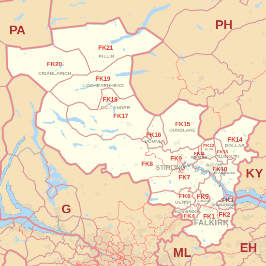
Map
Template:Attached KML/FK postcode area
KML is from Wikidata
FK postcode area map, showing postcode districts in red and post towns in grey text, with links to nearby
EH,
G,
KY,
ML,
PA and
PH postcode areas.
External links
|
|---|
|
| Crown dependencies | |
|---|
| Overseas territories | |
|---|
| Non-geographic | |
|---|
|